You’ll find Civer nestled in Putman Township, Fulton County, Illinois at 679 feet above sea level. This 19th-century prairie settlement emerged during the railroad expansion era, featuring a depot and general store that served local farmers and travelers. Without essential rail connections and overshadowed by nearby Canton’s industrial growth, Civer’s businesses and population gradually disappeared. Today, only historical markers hint at the compelling story of this vanished community‘s rise and fall.
Key Takeaways
- Civer was established as a prairie settlement in Illinois during the 19th century railroad expansion, with a depot and general store.
- Located in Putman Township, Fulton County at 679 feet elevation, surrounded by fertile prairies and small creeks.
- The town declined when businesses moved to nearby Canton, which had better railroad connections and industrial opportunities.
- Lack of direct rail access and major transportation routes severely limited Civer’s economic growth and eventual survival.
- Today, only historical markers remain as evidence of Civer’s existence, marking it as one of Illinois’ ghost towns.
The Rise and Fall of a Prairie Settlement
As railroads expanded across Illinois in the nineteenth century, Civer emerged as a small but significant prairie settlement centered around its depot and general store.
You’ll find that like many pioneer communities, Civer’s existence revolved around the railway, which brought essential supplies and connected residents to larger markets.
The prairie community faced typical pioneer challenges, relying heavily on agriculture and local services for survival.
While you won’t find records of major industries in Civer, the town served as a pivotal hub for nearby farmers and travelers.
Despite its lack of major industry, Civer provided vital services as a central meeting point for local agriculture and passing travelers.
Like many river towns of the era, such as Griggsville Landing, Civer worked to establish itself as a thriving rural community.
Like the early settlement of Salem in 1830, Civer worked to establish itself as a thriving rural community.
However, as rail transportation declined and economic opportunities shifted elsewhere, Civer couldn’t sustain itself.
Today, only a solitary sign marks where this once-hopeful settlement stood, joining countless other ghost towns that dot Illinois’s prairie landscape.
Geographic Location and Natural Features
Nestled in Putman Township of Fulton County, Illinois, Civer sits at an elevation of 679 feet above sea level.
You’ll find this ghost town at 40° 31′ 27″ N, 90° 06′ 27″ W, surrounded by the sweeping prairies that define the heartland. The topographic features around Civer showcase the gentle undulations typical of central Illinois, where small creeks weave through the landscape. Much like the rough terrain that isolated Moonville, the landscape played a role in shaping settlement patterns. Modern GPS technology allows visitors to locate the exact position using UTM coordinate system mapping.
The area’s rich, fertile soil has long supported agricultural land use, transforming the original prairie grasses and deciduous woodlands into productive farmland.
You’re in the midst of a humid continental climate zone here, where dramatic seasonal shifts shape the environment. While the town itself has vanished, you can still access the site via rural county roads, though there’s little remaining infrastructure in this unincorporated settlement that time has nearly forgotten.
Early Pioneers and Settlement Years
The early pioneers of Civer emerged during the broader settlement wave that swept through Fulton County in the 1830s and 1840s. Like their neighboring settlers, they were driven by pioneer motivations of establishing thriving agricultural communities with ambitious plans for growth and commerce.
You’ll find that these early settlers faced common settlement challenges of the era. They’d typically start by laying out village lots, establishing essential infrastructure like general stores and blacksmith shops, and building multipurpose structures that served as both schools and churches. Similar to Tuscumbia’s fate, the town struggled to maintain its population and eventually disappeared, with only a sign marking its former location.
Their vision included public squares and planned railroad connections, though not all transportation dreams materialized. Following the pattern of other Fulton County settlements, they’d prioritize education and religious institutions as cornerstones of community life, reflecting the determination of frontier families to build lasting foundations. The rapid expansion of Illinois from 2,458 settlers in 1800 shaped the growth expectations of these ambitious pioneers.
Life in 19th Century Civer
Life in 19th century Civer revolved around a close-knit farming community where survival demanded both self-sufficiency and cooperation.
You’d find families working their land, hunting wild game, and protecting their livestock from wolves while relying on homespun clothing and preserved meats to sustain them through lean times.
Community gatherings centered around the local schoolhouse, which doubled as a church and meeting place.
Educational challenges were significant – children’s attendance fluctuated with farming seasons, and the basic curriculum focused on reading, writing, and arithmetic.
You’d need to travel by horse and wagon on dirt roads to reach Ellisville for supplies you couldn’t produce yourself.
Despite the isolation created by poor transportation infrastructure, you’d witness how the settlement adapted through shared resources and mutual support among neighbors.
Like many small settlements under 200, Civer was considered a hamlet by Illinois population standards.
Written records of daily life were preserved by the University of Illinois, which collected historical documents from the region.
Economic Struggles Against Canton
As Civer’s residents watched businesses migrate to Canton in the late 1800s, you’d have noticed the town’s increasing isolation from major trade routes.
While Canton’s strategic position along the railroad lines gave its merchants direct access to wider markets, Civer’s lack of rail connections left local farmers and traders at a significant disadvantage.
You could see the economic gap widening as Canton’s railroad depot attracted more industries and workers, leaving Civer’s business district to gradually wither. The establishment of the Parlin & Orendorff Company in 1860 further cemented Canton’s dominance as the region’s industrial powerhouse. Canton’s strong manufacturing base in machinery and food processing continued to drive economic growth for decades to come.
Railroad Access Disadvantages
Located far from major rail hubs, Civer’s limited access via the Toledo, Peoria & Western Railway proved detrimental to its economic survival when competing against Canton’s robust mainline connections.
The rail competition highlighted Civer’s economic isolation, as Canton’s superior infrastructure attracted businesses and farmers seeking efficient transportation options.
You’ll understand Civer’s disadvantages through these stark realities:
- While Canton offered daily passenger and freight service to nationwide markets, Civer’s station provided only sporadic, unreliable connections.
- Higher shipping costs made Civer’s agricultural products less competitive, forcing local farmers to transport goods to Canton.
- Limited rail capacity prevented the development of industrial facilities, warehouses, and storage yards that might’ve sustained the town’s economy.
Business Migration to Canton
While Civer struggled to maintain its modest commercial presence, neighboring Canton’s industrial might proved an irresistible force that steadily drained businesses from the smaller settlement.
You’d have witnessed Canton’s superior infrastructure and growing market steadily pulling commerce away from Civer’s limited business opportunities. The pattern became clear as Canton’s diverse industrial base, anchored by powerhouses like Parlin & Orendorff and multiple cigar manufacturers, created an economic gravity that smaller enterprises couldn’t resist.
When International Harvester acquired local operations in 1919, it further centralized industry in Canton. The economic migration left Civer with dwindling options – its small depot and store proved insufficient to compete with Canton’s modern amenities, established workforce, and robust public services.
Transportation Networks and Missed Opportunities
You’ll find that Civer’s rail presence remained minimal, with the Toledo, Peoria & Western Railway stop never developing beyond a small depot despite early promise.
The settlement’s position just 3 miles from Canton proved particularly damaging, as major transportation routes naturally gravitated toward the larger town’s established commercial networks.
When modern highways later carved through Fulton County, they bypassed Civer entirely, leaving the former rail stop disconnected from the region’s evolving transportation arteries.
Railroad Access Never Materialized
Despite early promises and expectations, Civer’s crucial railroad connection never materialized, sealing the town’s fate in late 19th-century Illinois.
While neighboring Canton flourished with its essential rail access, Civer struggled with mounting transportation challenges that limited its growth potential and economic opportunities.
You’ll find that Civer’s railroad expectations crumbled due to three critical factors:
- The Toledo, Peoria & Western Railway chose a route that bypassed the town
- Early talks of rail construction raised false hopes among residents
- The lack of direct rail access forced businesses to rely on more costly transportation methods
Without the lifeline of rail transportation, you couldn’t establish the industries and commerce needed for sustained growth.
This isolation ultimately pushed residents toward more connected communities, leaving Civer to fade into history.
Regional Roads Bypassed Settlement
The isolation of Civer extended beyond its missing rail connection to encompass the broader regional transportation network.
You’ll find that major roads in Fulton County deliberately avoided the settlement, instead following established market routes that connected larger towns with river landings and railroad stops.
The county’s road infrastructure planning focused on linking economically active communities, leaving Civer cut off from crucial trade routes.
Without adequate road connections, you couldn’t easily reach regional markets or access essential services.
Transportation planning decisions by county and state officials favored routes between Canton, Cuba, and other prosperous towns, effectively strangling Civer’s growth potential.
This lack of accessibility meant local businesses struggled to attract customers, and farmers couldn’t efficiently transport their goods to market, accelerating the settlement’s decline.
Limited Stagecoach Service Impact
While stagecoach lines crisscrossed Illinois during the mid-1800s, Civer’s limited service left it struggling to compete with better-connected settlements.
You’d have witnessed the town’s transport limitations firsthand through:
- Stagecoaches arriving on sparse, unreliable schedules that deterred merchants from establishing permanent businesses
- Travelers bypassing Civer in favor of settlements with regular rail or river connections
- Mail and news arriving days or weeks later than in neighboring towns
The economic isolation took its toll as you’d watch residents gradually move away to places with better opportunities.
Without reliable stagecoach service, Civer couldn’t develop into a viable trading post or health resort like other Illinois towns.
The dwindling population and lack of new settlers sealed the settlement’s fate, transforming it from a hopeful frontier town into a disappearing community.
The Final Years of Civer
As railroad expansion swept through Illinois in the late 1800s, Civer’s unfortunate position between Canton and Cuba proved fatal to its survival.
Despite the community’s resilience, the town’s inability to secure a rail connection sealed its fate. You’d have witnessed families gradually moving away, taking their homes and businesses with them piece by piece.
Local folklore tells of the dismantling process, as residents relocated usable materials to neighboring towns with better prospects.
The schoolhouse and church – once vibrant centers of daily life – fell silent. Agricultural challenges and flooding only hastened Civer’s decline, while surrounding rail towns flourished with new trade opportunities.
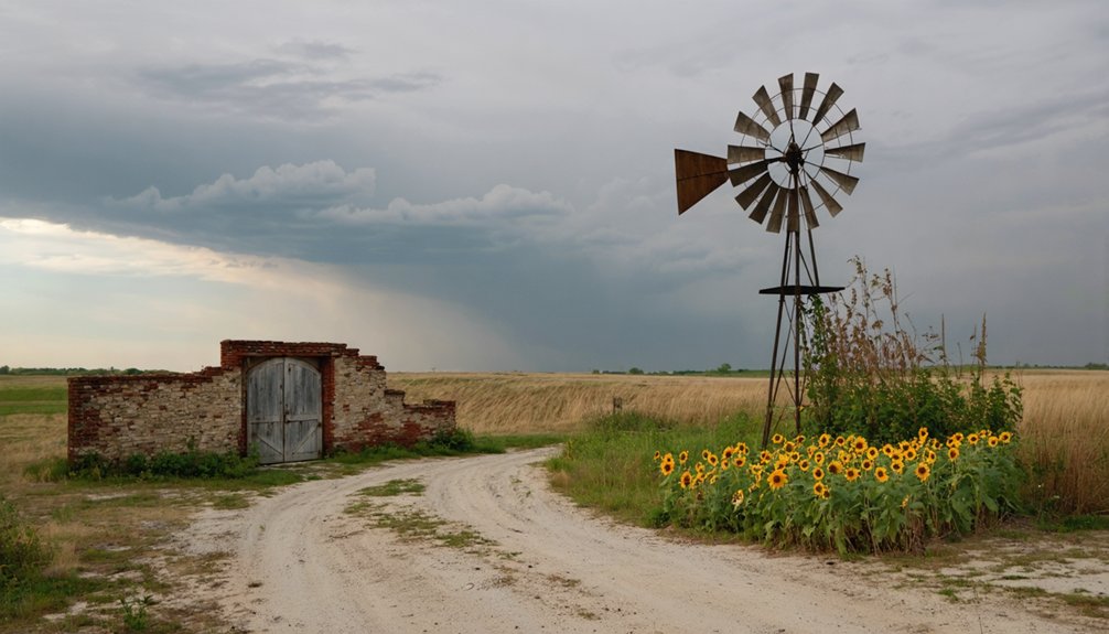
What Remains Today

Situated in Fulton County at an elevation of 679 feet, modern-day Civer exists only through historical markers that dot its former location.
Unlike some Illinois ghost towns that maintain visible structures, you’ll find no physical remnants of this once-vibrant community at coordinates 40°31′27″N 90°06′27″W.
exploring the history of challacombe reveals a story shaped by its once-bustling population and the landscape that surrounded it. As you delve into the past, you uncover tales of early settlers and the factors that led to the town’s decline. The remnants of their lives may be gone, but the echoes of their experiences still linger in the air.
Today, the landscape reveals:
- Natural overgrowth and farmland where buildings once stood
- Simple roadside signs commemorating the town’s existence
- Open countryside that’s reverted to its pre-settlement state
The area’s transformation mirrors other vanished towns in Fulton County, like Tuscumbia, where nature has reclaimed the land.
Like countless ghost towns across Fulton County, Civer’s story echoes in empty fields where communities once flourished.
Without preserved artifacts or foundations, Civer’s historical markers stand as sole witnesses to its past, leaving visitors to imagine the community that once thrived here.
Historical Significance and Legacy
Despite its brief existence, Civer represents a crucial chapter in Fulton County’s 19th-century development, illustrating how transportation networks shaped the fate of early Illinois settlements.
You’ll find that Civer’s story exemplifies how communities without rail access often struggled to compete with better-connected neighbors like Canton and Sepo.
In the broader historical context, Civer’s decline reveals the shifting community dynamics of 19th-century Illinois, as residents abandoned isolated farming settlements for towns offering stronger economic prospects.
While the physical town has vanished, its legacy endures through historical markers and documentation, serving as a compelling case study of rural settlement patterns.
Today, Civer stands as a reflection of how transportation access and economic forces determined which early Illinois communities would thrive or fade into memory.
Frequently Asked Questions
Were There Any Documented Natural Disasters That Affected Civer’s Population?
Like a clear sky without storms, you won’t find any documented natural calamities that impacted Civer’s population. Historical records show the town’s decline came from economic factors, not disasters.
Did Any Notable Crimes or Lawlessness Occur in Civer’s History?
You won’t find documented crime statistics or law enforcement records for this settlement. Historical books about Fulton County don’t mention any notable criminal activity during Civer’s brief existence.
What Native American Tribes Originally Inhabited the Civer Area?
While you’d expect just one tribe’s dominance, you’ll find the Illinois Confederation’s Peoria, Kaskaskia, and Cahokia tribes first inhabited this land, before the Kickapoo claimed their cultural heritage in the 1700s.
Were There Any Local Legends or Folklore Specific to Civer?
You won’t find documented local ghost stories or hauntings specific to Civer. While other Illinois ghost towns have rich folklore, no legends unique to this location appear in historical records or regional collections.
Did Any Famous Personalities Ever Visit or Stay in Civer?
Like a blank page in history’s book, you won’t find any celebrity sightings or historical visits to chronicle. No famous personalities ever graced this small settlement during its brief existence.
References
- http://cantontornado36.blogspot.com/2017/04/ghost-towns-of-fulton-county-illinois.html
- https://drloihjournal.blogspot.com/2022/04/lost-towns-of-illinois-civer-illinois.html
- http://cantontornado36.blogspot.com/2017/05/waterford-tuscumbia-civer-three.html
- https://en.wikipedia.org/wiki/Civer
- https://drloihjournal.blogspot.com/p/lost-towns-of-illinois-series.html
- https://kids.kiddle.co/Civer
- https://www.youtube.com/watch?v=93k0qtvzkn4
- https://freepages.rootsweb.com/~gtusa/history/usa/il.htm
- https://www.freakyfoottours.com/us/illinois/
- http://cantontornado36.blogspot.com/2017/04/fulton-county-ghost-towns-part-2.html