You’ll find Cleburne’s ghostly remains in Riley County, Kansas, where a once-thriving community of 225 residents lived until 1960. Originally named Big Timber in 1866, the settlement flourished alongside railroad tracks near Swede Creek and the Big Blue River. The Tuttle Creek Dam project forced 3,000 residents to relocate, leaving behind crumbling foundations and broken sidewalks in what’s now a deteriorating park. The story of this lost settlement reveals the steep cost of flood control progress.
Key Takeaways
- Cleburne was a thriving Kansas settlement established in 1866 that became a ghost town after the Tuttle Creek Dam project in 1960.
- The town reached its peak with 225 residents in 1910 before declining due to the planned construction of Tuttle Creek Lake.
- All residents were forced to relocate when the U.S. Army Corps of Engineers acquired 61,000 acres for the dam project.
- Today, only deteriorating foundations, broken sidewalks, and an aging park remain at the original townsite.
- The ghost town’s location in Riley County was originally vital for settlers due to its proximity to Swede Creek and Big Blue River.
From Big Timber to Ghost Town: A Historical Journey
When Cleburne first emerged in Riley County, Kansas around 1866, it bore the fitting name of Big Timber due to its location along a river within Swede Township.
Like many frontier settlements of its time, you’d have found this small town growing alongside the railroad tracks that connected it to the wider world. From these timber origins, Cleburne served as a crucial hub for local settlers and travelers alike. The town experienced steady growth and reached a population of 225 residents by 1910.
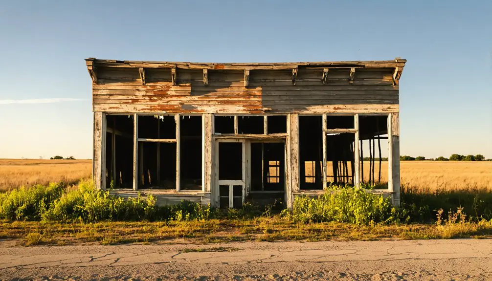
Today, the abandoned townsite has been transformed into a deteriorating park that stands as a testament to its past.
You can trace the community’s decline to the 1950s when the Tuttle Creek Dam project began reshaping the region.
Life Along the River: Settlement and Community
Three distinct waterways – Swede Creek, the Big Blue River, and their confluence – shaped the early settlement of Cleburne, Kansas.
You’ll find the fingerprints of early settlers like L. Pierson, N. Christenson, and the Meyer brothers who recognized the potential of this fertile river valley. The area’s cultural diversity flourished as Swedish immigrants, including Peter Carlson, arrived in 1857, while German settlers established their Evangelical Church in 1877.
Life along these waterways centered around farming, milling, and community building. The fertile alluvial deposits from periodic flooding enriched the valley soil for agriculture.
The town’s existence came to an end when it was razed for Tuttle Creek Dam in 1960, erasing decades of history and community life.
You can trace the town’s growth through its five schoolhouses – three stone and two frame buildings – that served the expanding population. The establishment of a post office in 1878, with Maynus Vilander as postmaster, marked Cleburne’s emergence as a proper settlement, though it had begun as part of the former Kansa Indian reservation.
The Tuttle Creek Dam Project’s Impact
Between 1952 and 1965, you’d have witnessed the U.S. Army Corps of Engineers acquiring over 61,000 acres through purchases and flowage easements, transforming the Blue River Valley’s agricultural heritage into a massive flood control project.
While the dam construction aimed at flood mitigation, protecting cities like Manhattan and Topeka, it came at a steep price for local residents. The project’s total cost reached $80 million dollars, demonstrating the massive scale of this undertaking.
You would’ve heard the rallying cry “Let’s quit this dam foolishness” as families fought to preserve their homes and farmland. Despite fierce opposition and temporary construction delays, the project proceeded.
When the dam closed in 1959, it submerged roughly 12,350 acres of fertile farmland, displacing generations of farmers and forever altering the region’s character.
The flood control project proved its worth during the Great Flood of 1993, preventing significant damage to downstream communities.
Natural Features and Geographic Significance
Situated in Riley County’s northwest region, Cleburne flourished within the distinctive Flint Hills landscape, where limestone formations and rolling prairies created an ideal setting for early settlement.
Similar to communities like Geuda Springs, the area contained natural mineral springs that added to its appeal. The town’s geographic features included rich clay soils and strategic positioning near waterways, making it attractive for farming and commerce. The town was permanently submerged when Tuttle Creek Lake was created by damming the Big Blue River in the 1960s.
The area’s ecological significance stems from its unique Flint Hills ecosystem, supporting diverse wildlife and native grasslands.
- You’ll find limestone-based karst features that hint at the region’s ancient geological history
- The native prairies host a variety of wildlife, from deer to numerous bird species
- Rich soil composition supported successful agricultural ventures
- Tuttle Creek Lake’s construction dramatically altered the original landscape, though it created new recreational opportunities
Legacy of a Lost Kansas Settlement
Once thriving as a small river settlement, Cleburne met its end in 1960 when the Tuttle Creek Dam project forced roughly 3,000 residents to relocate and abandon their homes.
Today, you’ll find only scattered remnants of this lost community – crumbling foundations, broken sidewalks, and an aging park that’s slowly being reclaimed by nature.
While the town’s physical presence has faded, its story of community resilience lives on through local historians and researchers who document its significance.
The displacement of Cleburne, along with eight other towns, represents a pivotal moment in Kansas history when rural communities were sacrificed for flood control infrastructure.
Despite the passage of time, the deteriorating remains at Cleburne Park serve as silent witnesses to this historical memory, reminding visitors of the price paid for progress.
Like Diamond Creek Cemetery, these ruins stand as the final testament to a once-vibrant community’s existence.
Frequently Asked Questions
Were There Any Notable Crimes or Lawlessness in Cleburne’s History?
Despite scrolling through historical Instagram, you won’t find any documented Cleburne lawlessness or crimes. Unlike other Kansas towns with wild west reputations, Cleburne’s story focuses on displacement by Tuttle Creek Reservoir.
The history of Cofachiqui, Kansas reveals a different narrative marked by its cultural significance and the crossroads of early Native American tribes. While Cleburne’s legacy is tied to relocation, Cofachiqui stands as a testament to the rich heritage and stories of its past inhabitants. This contrasts sharply with the less romanticized tales from neighboring towns that have since faded into obscurity.
What Types of Businesses and Stores Operated in Cleburne?
You’d find grocery stores, blacksmith shops, doctor’s offices, drugstores, hotels, post offices, brothels, bars, dance halls, and general stores serving both locals and railroad workers throughout town’s peak years.
How Many People Lived in Cleburne During Its Peak Population?
Like grains of wheat scattered in the Kansas wind, Cleburne’s peak growth remained modest. You won’t find exact demographics, but records suggest the population likely ranged between 100-300 residents at its height.
Did Any Famous Historical Figures Ever Visit or Stay in Cleburne?
You won’t find records of any famous visitors in Cleburne’s history. The town lacked the historical significance to attract notable figures before its destruction for the Tuttle Creek Dam project.
What Happened to the Displaced Residents After the Town’s Destruction?
You’ll find most displaced families sought new beginnings in neighboring towns, while others ventured further. Though town relocation efforts weren’t officially organized, folks made individual choices to rebuild their lives elsewhere.
References
- https://www.youtube.com/watch?v=OyQI18Rfkgk
- https://www.onxmaps.com/offroad/beginner-offroad-trails-near-me/ogden-ks
- https://www.youtube.com/watch?v=OyBXD18P_j4
- https://legendsofkansas.com/riley-county-extinct-towns/
- https://www.rileycountyks.gov/441/History-of-Riley-County
- https://legendsofkansas.com/cleburne-kansas/
- https://www.humanitieskansas.org/get-involved/kansas-stories/places/mining-for-stories-in-a-kansas-ghost-town
- https://www.rileycountyks.gov/335/1921-1930
- https://digital.library.unt.edu/ark:/67531/metadc663810/m2/1/high_res_d/1002603812-Gay.pdf
- https://www.kgs.ku.edu/General/Geology/Riley/geog01.html


