You’ll find the ghost town of Corydon, Pennsylvania submerged beneath the Allegheny Reservoir since 1965 when the Kinzua Dam project flooded the area. Once a thriving lumber community established in 1846, Corydon grew into an economic hub with sawmills, railroads, and hotels serving its growing population. When water levels drop, you can spot remnants of the town’s structures, military bunkers, and the historic Stone Church that still stands as a memorial to this lost community.
Key Takeaways
- Corydon, Pennsylvania became a ghost town in 1965 when the Kinzua Dam construction submerged the entire township beneath the Allegheny Reservoir.
- The original settlement was established in 1846 and thrived as a lumber industry hub until its forced abandonment.
- Military-style bunkers and remnants of the ghost town become visible during low water levels in the Allegheny Reservoir.
- The Stone Church remains as one of the few accessible landmarks, serving as a memorial to the submerged community.
- Nearly 700 Seneca families were displaced from their ancestral lands when Corydon was flooded for Pittsburgh’s flood protection.
The Birth of Corydon Township (1846)
While several townships in Pennsylvania’s northern tier emerged in the early 1800s, Corydon Township wasn’t officially established until March 20, 1846, when Warren County courts ordered its creation from a narrow strip of McKean County territory along the Allegheny River‘s western edge.
You’ll find it interesting that this administrative decision created an unusual situation – two adjacent townships sharing the name Corydon. The original Corydon Township remained in McKean County, where it had existed since 1829, while the new township took shape in Warren County’s northeastern corner. A clear disambiguation page now helps visitors distinguish between these similarly named locations.
The Corydon geography was primarily defined by its position along the Allegheny River, marking a crucial boundary between the counties. This frontier community would remain relatively untouched until transportation improvements arrived in the 1880s. The area held significant archaeological value, containing Sugar Run Mounds that served as ancient Native American burial grounds dating back approximately 1,000 years.
Philip Tome: Pioneer and Native Interpreter
If you’d tracked Philip Tome’s early life, you’d find him born in 1782 near present-day Harrisburg, where he developed hunting skills in Pennsylvania’s wildlife-rich frontier.
His German family’s settlement along the West Branch of the Susquehanna River in 1791 placed him in territory abundant with bears, elk, deer, and wild turkeys. Tome became so skilled that he and his brother captured and sold their last elk for market hunting in 1822.
You’ll note his eventual role as Cornplanter’s trusted interpreter stemmed from these wilderness experiences, leading to fifteen years of facilitating communication between Seneca chiefs and European settlers along the Allegheny River.
In 1827, Tome became the first settler of Corydon Township, establishing himself in the northeastern corner of Warren County despite challenges from local tribes.
Early Life Near Harrisburg
Born near Harrisburg in 1782, Philip Tome emerged as one of Pennsylvania’s most influential frontier figures during the late 18th century.
Born to parents of German descent, he’d develop vital frontier skills that would shape his remarkable future as a hunter, interpreter, and pioneer. His experiences would later be chronicled in Pioneer Life, a rare book with fewer than 500 copies printed.
You’ll find Tome’s early years marked by:
- Extensive hunting and trapping expeditions in the wilderness north of Harrisburg
- Natural aptitude for outdoor survival and frontier navigation
- Deep immersion in Native American communities near the settlement
- Development of significant language skills through Native interactions
- Mastery of wilderness tracking and hunting techniques
These formative experiences near Harrisburg laid the groundwork for Tome’s later roles as a respected interpreter for Seneca chiefs and his eventual settlement in Corydon, where he’d continue to bridge the gap between settlers and Native communities. His detailed records and collections would later become invaluable resources in digital collection management, preserving this crucial period of Pennsylvania’s frontier history.
Cornplanter’s Trusted Voice
Philip Tome’s early experiences near Harrisburg prepared him for his most significant role: serving as Chief Cornplanter’s trusted interpreter for fifteen years.
Through cultural diplomacy, he bridged the complex world between Native Americans and European settlers during a pivotal time in Pennsylvania’s frontier history. Since Cornplanter did not speak English, Tome’s interpretive skills were crucial for communications.
His understanding of Seneca customs and frontier life made him essential during negotiations between the Six Nations Confederacy and U.S. officials. His tales of hunting in the Pennsylvania wilderness became legendary among his contemporaries. As tensions rose between settlers and Native Americans, Tome’s trusted position helped maintain crucial communications and peace efforts in northern Warren County, where he’d later spend his final days in Corydon.
You’ll find Tome’s influence extended beyond mere translation. He combined his hunting traditions with diplomatic skills while interpreting for both Cornplanter and Governor Blacksnake along the Allegheny River.
Railroad Development and Economic Boom
During the mid-19th century, Pennsylvania’s railroad development transformed Corydon from a remote settlement into a bustling economic hub.
You’ll find that railroad innovation drove unprecedented growth as the Pennsylvania Railroad expanded its reach across the state, creating new opportunities for commerce and industry. Under the leadership of J. Edgar Thomson, the railroad’s strategic planning and engineering expertise helped establish crucial transportation corridors throughout Pennsylvania. The railroad’s success led it to become the largest corporation worldwide at its peak of operations.
The economic transformation that swept through Corydon brought:
The sweeping economic transformation reshaped Corydon into a powerhouse of progress, unlocking new possibilities for growth and prosperity.
- Direct access to major markets in Philadelphia, Pittsburgh, and beyond
- New industrial and commercial enterprises sprouting around the depot
- Year-round transportation capabilities for local goods and raw materials
- Increased population as workers flocked to emerging job opportunities
- Rapid development of local services and businesses near the rail line
The railroad’s strategic placement of tracks and facilities through Corydon positioned the town perfectly to capitalize on Pennsylvania’s industrial boom, connecting you to a vast network that stretched across 12,000 miles of American landscape.
Industries That Shaped Corydon
You’ll find Corydon’s industrial heart centered on its lumber mills, which began with a massive 17,000-acre timberland purchase that launched large-scale milling operations.
The arrival of railroad connections in the 1880s transformed Corydon into a bustling manufacturing hub, where sawmills, pulp mills, and specialized wood product factories flourished.
The town’s natural resources, particularly its abundant timber, supported a diverse industrial base that included stave mills, spoke factories, and handle manufacturing facilities, all of which provided essential employment for local residents.
Lumber Mills Drive Growth
Two enterprising Vermont businessmen, Clark and Sanderson, sparked Corydon’s transformation into a lumber town when they purchased 17,000 acres of timberland for $75,000 in the 1830s.
This bold investment launched the lumber industry that would drive McKean County’s economic transformation throughout the 19th century.
You’ll find these key developments shaped Corydon’s rapid growth:
- White pine became the region’s most profitable timber product
- Oswayo Creek served as an essential transportation route for logs
- Large mills processed local timber, employing scores of workers
- The 1881 railroad arrival triggered a significant production boom
- Jamestown Wood Pulp and Paper Mill emerged as the town’s largest industry
The lumber boom attracted immigrants and workers from across states, while cleared bottomlands gradually gave way to farming, creating a diverse economic base.
Railroad Sparks Economic Boom
While lumber mills laid the foundation for Corydon’s early growth, the arrival of the Buffalo, New York & Philadelphia Railroad in 1881 sparked an unprecedented economic transformation.
You’d find Corydon’s isolation ended as the railroad replaced stagecoach transport, connecting the township to lucrative national markets.
The rail’s impact on Corydon history proved revolutionary. You could witness the emergence of diverse industries – from the dominant Jamestown Wood Pulp and Paper Mill to stave mills, spoke factories, and handle manufacturing.
The economic transformation accelerated when the railroad coincided with a local oil boom, turning this once-isolated farming community into a thriving industrial hub.
Natural Resource Manufacturing Hub
Throughout the late 19th century, Corydon emerged as a powerhouse of natural resource manufacturing, anchored by Clark and Sanderson’s massive 17,000-acre timberland investment of $75,000.
The town’s lumber production flourished with the arrival of rail transport in 1881, establishing a robust resource management system that transformed raw timber into valuable products.
You’ll find Corydon’s manufacturing diversity reflected in these key operations:
- Stave-mills crafting essential barrel components
- Spoke factories supplying the wagon industry
- Handle manufacturing for tools and implements
- Shingle mills producing roofing materials
- Pulp operations processing wood fiber
While coal mining existed nearby in places like Instanter and Mt. Alton, it never rivaled the dominance of wood-based industries.
The region’s natural resources also supported oil production and gas operations, though these remained secondary to Corydon’s thriving lumber economy.
The Rise of Local Commerce and Community
After remaining sparsely populated for several decades, Corydon Township’s commercial landscape dramatically transformed with the arrival of the B., N.Y. & P. Railroad in 1882.
You’d have witnessed unprecedented commerce growth as general stores, hotels, and groceries emerged to serve the expanding population.
The town’s industrial base diversified rapidly, with stave mills, spoke factories, and handle factories establishing operations.
These businesses capitalized on local timber resources while creating jobs and fostering community resilience.
You would’ve found the township’s social fabric strengthening around these commercial hubs, where residents gathered not just for transactions but for community connection.
Local commerce created a self-sustaining environment where you could find everything from essential services to manufacturing employment, marking Corydon’s evolution from scattered homesteads to a vibrant economic center.
The Kinzua Dam Project’s Impact
As construction of the Kinzua Dam began in the early 1960s, you’d have witnessed one of the most controversial and transformative projects in northwestern Pennsylvania’s history.
The $125 million federal project permanently altered Corydon’s landscape and surrounding communities, leading to widespread cultural displacement.
The dam’s impact on the region was profound:
- Submerged over 9,000 acres of Seneca Nation territory, including the historic Cornplanter Tract
- Created a 27-mile-long reservoir that became Pennsylvania’s second deepest lake
- Forced relocation of nearly 700 Seneca families from their ancestral lands
- Transformed previously inhabited areas into a massive flood control system
- Divided communities with new roadways and infrastructure
The project, completed in 1965, prioritized Pittsburgh’s flood protection over indigenous sovereignty, earning the reservoir the name “Lake of Perfidy” among the Seneca people.
Life Beneath the Allegheny Reservoir
Today, if you look down into the depths of the Allegheny Reservoir, you’ll find the hidden remnants of Corydon’s foundations, including the old railroad tracks that once connected the bustling lumber town to the outside world.
The submerged pioneer settlement, established by early settlers like Phillip Tome in 1827, now rests beneath 24 miles of reservoir waters.
You’re floating above what was once a thriving community of 748 residents, complete with a Methodist church, lumber mill, and various local businesses that defined small-town Pennsylvania life until 1965.
Hidden Underwater Foundations Remain
When the Allegheny Reservoir filled in 1965 following Kinzua Dam‘s completion, it permanently submerged the original village of Corydon at the confluence of Willow Creek and the Allegheny River.
Today, underwater archaeology reveals a preserved time capsule of this once-thriving community’s foundations beneath the reservoir’s surface.
You’ll find these remnants of historical preservation protected from surface weathering, though they face different challenges in their aquatic environment:
- Building foundations remain largely intact under the water
- Sonar mapping shows detailed underwater topography of the old town
- Submerged structures create habitat for freshwater mussels
- Regular bathymetric surveys monitor foundation conditions
- Sediment and water dynamics continue shaping these historic remains
These underwater foundations serve as silent witnesses to Corydon’s forced relocation and adaptation to change.
Railroad Tracks Below Water
Deep beneath the Allegheny Reservoir’s waters lie the remnants of a once-bustling railroad network that served timber camps and mill towns throughout the valley.
You’ll find submerged tracks that once connected thriving communities like Guffey and Morrison to the Pennsylvania Railroad’s western terminus, following the natural contours of Kinzua Creek.
These historical remnants tell the story of an era when steam locomotives hauled timber from remote camps, maneuvering grades with innovative engineering solutions.
The tracks remain preserved underwater since the 1960 flooding, marking where villages like Kushequa and Westline once stood.
While reservoir water levels fluctuate and affect shoreline stability, the submerged railroad infrastructure stays largely undisturbed, a silent reflection of the region’s timber-rich past.
Pioneer Settlement Now Submerged
Beneath the tranquil waters of the Allegheny Reservoir lies Corydon, a pioneer settlement that vanished in 1965 during the construction of the Kinzua Dam.
You’ll find a rich pioneer heritage now preserved only in memory, as the township’s buildings, homes, and landmarks rest silently underwater.
Before its submersion, Corydon faced typical frontier challenges:
- Devastating fire of 1902 that destroyed part of the business district
- Ice jam damage to homes in 1918
- Early conflicts near the Seneca Indian Reservation
- Boundary disputes affecting jurisdiction
- Natural disasters and industrial accidents testing community resilience
This submerged history tells a compelling story of rural Pennsylvania life, where determined settlers built their community despite adversity.
While you can’t visit the physical town today, its legacy endures through preserved artifacts and local accounts.
Preserving Corydon’s Historical Legacy
Although Corydon Township no longer exists physically due to the Kinzua Dam‘s construction, its historical legacy lives on through multiple preservation efforts.
You’ll find dedicated cultural preservation initiatives at the Warren County Historical Society, where they’ve digitized township records, settler documents, and Philip Tome’s influential writings. Local historians focus on artifact documentation of remaining structures around the Allegany Reservoir, while protecting archeological sites from natural degradation.
You can explore this heritage through educational programs, museum exhibits, and guided tours that bring Corydon’s pioneer story to life.
The township’s memory endures through oral histories from residents’ descendants, community gatherings, and partnerships with Native American groups – honoring the area’s rich cultural connections through historical interpreters like Philip Tome.
Comparing Corydon and Centralia
While both Pennsylvania ghost towns share mining-industry roots, Corydon and Centralia tell dramatically different stories of decline.
You’ll find Corydon’s decline followed a familiar pattern of economic downturn and resource depletion, while Centralia’s fate was sealed by an environmental catastrophe that continues today.
- Centralia’s underground fire has burned since 1962, forcing 1,200 residents to evacuate
- Corydon decline happened gradually due to mining industry collapse
- Centralia fire creates ongoing hazards like toxic gases and sinkholes
- Corydon’s abandonment stemmed from economic factors, not environmental disaster
- Centralia draws tourists and inspired pop culture, including “Silent Hill,” while Corydon remains a quieter historical site
The contrast between these towns highlights how different forces can transform thriving communities into ghost towns, with Centralia’s dramatic story overshadowing Corydon’s more typical tale.
Visiting Pennsylvania’s Submerged Ghost Town
Today’s visitors to Corydon, Pennsylvania won’t find a typical ghost town to explore – instead, they’ll discover a unique underwater settlement beneath the Allegheny Reservoir.
While the original town lies submerged since 1965, you can still connect with Corydon memories by visiting several accessible landmarks in the surrounding area.
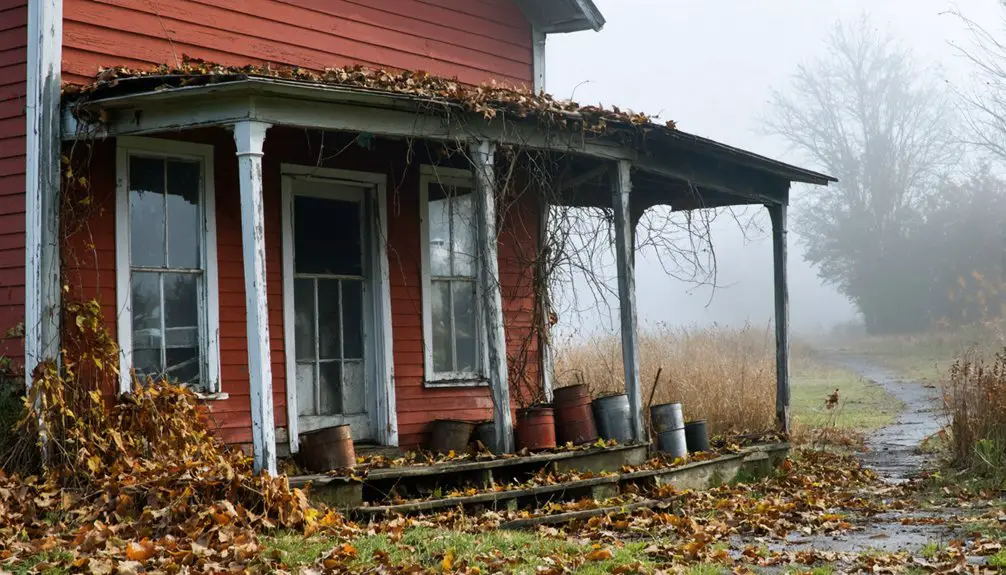
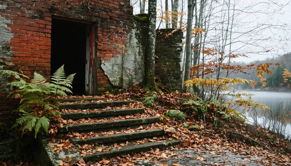
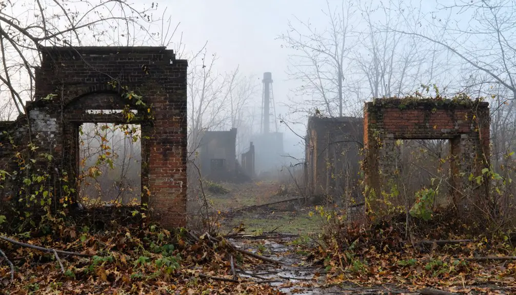
The Stone Church stands as a tribute to the community’s past, hosting occasional events and offering rare glimpses inside. You’ll find several preserved cemeteries nearby, and when reservoir levels drop, you might spot submerged artifacts like building foundations emerging from the waters.
For the best experience, check water levels before visiting, as seasonal changes affect which remnants you’ll be able to see. Military-style bunkers and other ghost town structures in the vicinity provide additional opportunities for historical exploration.
Frequently Asked Questions
What Happened to the Residents of Corydon After the Dam Construction?
Home is where the heart is, but you’d find Corydon’s residents scattered after the dam’s impact, with some moving nearby in Warren County while others relocated elsewhere, losing their community, jobs, and heritage.
Were Any Buildings or Structures Relocated Before the Flooding?
You won’t find records of building preservation or structure relocation before the flooding, despite any historical significance. While some communities saved buildings during dam projects, there’s no evidence Corydon’s structures were moved.
Can Artifacts From Corydon Still Be Found During Low Water Levels?
Along exposed muddy shorelines, you’ll discover remnants of the past as water levels drop. Artifact discovery reveals historically significant items like tools, ceramics, and industrial remains during reservoir drawdowns.
How Much Compensation Did Residents Receive for Their Relocated Properties?
You won’t find specific compensation details or property appraisals for this location, though similar Pennsylvania ghost town relocations typically paid fair market value plus moving expenses under eminent domain laws.
Did Any Original Corydon Families Remain in the Surrounding Warren County Area?
While some Corydon descendants stayed in Warren County after the 1965 relocation, you’ll find that detailed records don’t clearly document which original families maintained continuous residence in the surrounding region.
References
- https://pabucketlist.com/the-rise-and-fall-of-centralia-pas-toxic-ghost-town/
- https://www.youtube.com/watch?v=8QDb8y9Nszs
- https://www.youtube.com/watch?v=J93tAO-98Mo
- https://www.warrenhistory.org/People & Places Trunk/6Corydon Twp.html
- https://uncoveringpa.com/ghost-towns-in-pa
- https://www.timesobserver.com/history/2023/06/sugar-run-mounds-tell-little-understood-part-of-county-history/
- https://en.wikipedia.org/wiki/Corydon_Township
- https://www.warren.pagenweb.org/townships/Corydon.html
- https://kids.kiddle.co/Corydon_Township
- https://www.mountainhomemag.com/2014/04/17/186960/the-great-hunter


