You’ll find Currant, Nevada at the junction of U.S. Route 6 and State Route 379, where a farming settlement established in 1868 grew into a bustling community of fifty residents by 1883. After gold’s discovery in 1914 and magnesite mining from 1939 to 1942, the town gradually declined. Today, this semi-ghost town maintains a population of about sixty-five, supported by small oil wells. The remaining structures and mining artifacts tell a deeper story of Nevada’s boom-and-bust frontier.
Key Takeaways
- Currant evolved from an 1868 farming settlement into a semi-ghost town with approximately 65 residents maintaining minimal services.
- Located at the junction of US 6 and State Route 379, Currant experienced mining booms with gold and magnesite discoveries.
- The town’s decline followed the end of magnesite mining in 1942, leading to business closures and infrastructure deterioration.
- Small oil wells currently support the remaining population, while most historic businesses and the schoolhouse have been lost.
- Visitors can explore mining artifacts and experience authentic ghost town atmosphere while enjoying dark skies for stargazing.
From Pioneer Settlement to Semi-Ghost Town
While many Nevada boomtowns emerged from mining discoveries, Currant’s origins in 1868 began as a modest farming settlement that served as a crucial supply point for Railroad Valley ranches.
You’ll find pioneer challenges were met with community resilience as about ten families established the initial homesteads, growing to fifty residents by 1883.
The settlement’s strategic location at the junction of US 6 and State Route 379 made it a crucial stagecoach stop serving routes to Tybo, Eureka, Hamilton, and White River. Most residents now support themselves by working at small oil wells to the south.
Though gold was discovered in 1914 and magnesite mining briefly flourished from 1939 to 1942, Currant never experienced the explosive growth of typical mining towns.
Instead, you’ll trace its gradual shift to a semi-ghost town, marked by closing businesses, a destroyed schoolhouse, and a dwindling population that stabilized around sixty-five residents.
Life Along America’s Loneliest Road
Although U.S. Highway 50 spans 287 miles of Nevada’s most isolated landscapes, you’ll find unexpected adventures along America’s Loneliest Road.
You’ll encounter Cave Lake State Park at 7,300 feet elevation, offering serene camping and picnicking opportunities. You’re following the historic Pony Express trail, where well-preserved relay stations like Sand Springs showcase the route’s historical significance. When you tackle the 600-foot Sand Mountain dunes or explore wind-beaten ghost towns, you’ll experience the same rugged terrain that challenged 19th-century pioneers.
Since 1986, you can earn your “Silver State Survivor” status by collecting passport stamps in towns like Ely, Eureka, and Austin. Recent data shows that increased tourist traffic has changed U.S. Route 50’s status as the nation’s most desolate highway.
Earn your Nevada bragging rights by stamping your way across historic mining towns along the Loneliest Road.
While traffic remains sparse compared to other highways, you’ll discover authentic western saloons, mining ruins, and state parks. The route’s official “Loneliest Road” designation perfectly captures the solitary beauty of this desolate corridor through Nevada’s untamed frontier.
Mining Dreams and Rural Reality
Since its humble beginnings as a homestead settlement in 1868, Currant emerged as a strategic crossroads serving Nevada’s frontier ambitions.
You’ll find a mining history that mirrors the boom-and-bust cycles common to rural Nevada, with gold discovered in 1914 at the Shepherd Ranch and the short-lived Sunrise mine opening in 1916.
The rural economy diversified beyond mining dreams when Tom Windous discovered magnesite and the team of Steve Pappas and George Bogdanovich found high-grade gold in 1939. Like many Nevada mining operations, these developments followed the state’s pattern of precious metals domination in the industry.
These operations lasted until 1942, but Currant’s true staying power came from its role as a provisioning hub. Located at 6,437 feet elevation, the town shared similar high-altitude challenges with other mining settlements in the region.
While mining ventures faded, the town maintained its identity through small stores, a saloon, and traveler services along Highway 6, though even these eventually succumbed to the reality of declining population.
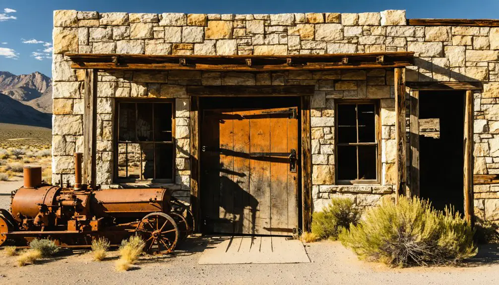
Surviving Structures and Lost Services
Today’s visitors to Currant will find a telling mix of standing structures and absent services that paint a picture of its former importance. The surviving buildings include the mine boss’s house and several worker cabins, while stone structures like the old jail have weathered time’s passage. Much like the remarkable Jailhouse Casino and Motel in Ely, Currant’s structures tell compelling stories of the region’s past.
Similar to catastrophic fires that devastated Goldfield in 1923, Currant’s structures faced their own destructive forces over time. You’ll notice many lost infrastructure elements, as fires and floods have claimed most commercial buildings and services that once defined this bustling town.
- The water tower stands as a silent sentinel, marking where essential infrastructure once served the community
- Original dirt paths remain traceable, though paved streets have vanished
- The cemetery preserves stories of settlers through ethnic plots and veteran graves
- Stone structures prove more resilient than wooden ones, which largely succumbed to fire and neglect
Visiting the Modern Ghost Town
While many ghost towns prove difficult to reach, Currant’s location along U.S. Route 6 makes it readily accessible by conventional vehicle.
Currant delivers an accessible slice of Nevada history, right off U.S. Route 6, welcoming explorers without demanding a rugged vehicle.
You’ll find a raw, authentic ghost town experience with foundational remnants and scattered mining artifacts preserved by the arid climate. The area’s proximity to Highway 50, known as the Loneliest Road in America, connects visitors to Nevada’s rich mining history. Similar to Gold Point’s allure, the site allows for dark sky viewing, offering excellent photographic opportunities, combining historical ruins with sweeping desert vistas.
exploring candelaria’s historical significance provides a deeper understanding of the region’s mining legacy and the lives of those who once thrived in this desolate landscape. The remnants tell stories of ambition and hardship, shedding light on the challenges faced by early settlers. As you wander through the ruins, you’ll feel a connection to the past that enriches the overall experience of this unique destination.
For the best visitor experience, bring water and sun protection, and wear sturdy shoes for exploring the informal trails around building ruins and mine tailings.
You’ll want to research the site’s historical significance beforehand, as interpretive materials are limited.
Consider including nearby ghost towns like Hamilton and Treasure City in your journey to understand the broader context of Nevada’s mining heritage. The area’s dark skies make nighttime stargazing particularly rewarding.
Frequently Asked Questions
What Happened to the Families Who First Settled in Currant?
You’ll find most settler experiences ended with families relocating after mining declined in 1942, though some family legacies continued through descendants who stayed, maintaining a small population of 60-65 residents.
Are There Any Documented Paranormal Activities or Ghost Stories From Currant?
You won’t find documented ghost sightings or haunted locations in Currant. While the town’s colorful history includes gangsters and nuclear testing evacuations, there aren’t any verified paranormal activities or established ghost stories.
What Is the Closest Major City to Currant, Nevada?
Like a desert oasis rising from Nevada’s lonely highways, Ely is your closest major city, sitting about 80 miles east-northeast. While Las Vegas lies hundreds of miles south, Ely’s your best bet for supplies.
Do Any Descendants of Original Settlers Still Live in Currant?
You won’t find documented descendant stories or family legacies of original settlers living in Currant today. Historical records suggest most families moved away when mining declined, leaving the town largely abandoned.
What Wildlife Can Typically Be Seen Around the Currant Area?
You’ll spot diverse local fauna including desert bighorn sheep, mountain lions, coyotes, and pronghorn antelope. Wildlife sightings often include raptors, sage grouse, lizards, and various snake species.
References
- https://www.ghosttowns.com/states/nv/currant.htm
- http://www.nv-landmarks.com/towns-c/currant.htm
- https://www.nvexpeditions.com/nye/currant.php
- https://nvtami.com/2024/07/23/ely-explorations/
- https://www.youtube.com/watch?v=iXS3-RPMcZU
- https://travelnevada.com/nevada-magazine/ghost-town-primer/
- https://en.wikipedia.org/wiki/List_of_ghost_towns_in_Nevada
- https://www.truckeehistory.org/uploads/5/1/9/2/51923135/library_index12.21.17web.pdf
- https://bigthink.com/strange-maps/americas-loneliest-roads/
- https://austinnevada.com/loneliest-road


