Cuyamaca City sprang to life after Fred Coleman’s 1870 gold discovery in San Diego County’s mountains. You’ll find its rise centered around the lucrative Stonewall Mine, which produced over $2 million in gold before closing in 1906. The thriving community of 500 residents included miners’ bunkhouses, family cabins, and a general store. Today, you can explore archaeological remnants and foundation stones along marked trails in Cuyamaca Rancho State Park, where California’s mining heritage quietly awaits.
Key Takeaways
- Cuyamaca City emerged after Fred Coleman’s 1870 gold discovery, quickly growing with 40 mining claims staked within a month.
- The Stonewall Mine became San Diego County’s largest gold producer, supporting a community of 500 residents from 1870-1899.
- Daily life featured bunkhouses, family cabins, a general store serving as a social hub, and community education services.
- The town’s economic collapse began with the Stonewall Mine’s 1906 closure, exposing vulnerabilities of single-industry dependence.
- Archaeological remains include stone foundations from mining operations, with nearby hiking trails now connecting historic ruins to Cuyamaca Rancho State Park.
Gold Discovery and the Birth of a Boomtown
While traversing a creek in the Cuyamaca Mountains in early 1870, rancher Fred Coleman’s keen eye caught the unmistakable glimmer of yellow particles that would forever change the region’s destiny. His discovery ignited a frenzied gold rush, with 40 mining claims staked within a month.
A golden glimmer in Cuyamaca’s waters sparked a rush that transformed California’s backcountry overnight.
You’d have witnessed an extraordinary transformation as prospectors flooded the area, employing placer mining techniques in the mountain streams.
The landscape quickly sprouted tent settlements, with Emily City emerging near Coleman’s find and Cuyamaca City blossoming alongside Lake Cuyamaca—a reservoir built specifically for mining operations.
The Stonewall Mine discovery south of Julian proved particularly lucrative, drawing 500 people to Cuyamaca Valley within hours. The mine would go on to produce over two million dollars in gold during its operational lifetime from 1870 to 1899. This southern California gold country became part of the broader quest for fortune that defined mid-nineteenth-century American freedom and opportunity. Julian City quickly grew into a substantial settlement with nearly 2,000 residents within two years of the initial gold discovery.
The Rise and Dominance of Stonewall Mine
Despite its modest beginnings in a chance encounter between William Skidmore and a stray mule, the Stonewall Mine would emerge as the crown jewel of San Diego County’s gold country.
Under Robert W. Waterman’s leadership, the mine reached its zenith, employing advanced mining techniques that allowed workers to extract high-grade ore from depths reaching 800 feet.
His son Waldo’s engineering expertise revolutionized operations, maximizing yields through innovative methods including cyanide processing of tailings.
The economic impact was transformative—producing over $2 million in gold between 1870-1892 and supporting a thriving community of 500 residents. This impressive output established Stonewall as the largest gold mine in San Diego County history.
You can imagine wagons loaded with precious bullion making their way down the Alpine road to San Diego, returning with vital supplies that kept this isolated but vibrant mountain boomtown flourishing at the height of California’s golden era.
Among the skilled workers at this impressive operation was Winfield Scott Clark, who in 1889 secured employment as an engineer at the mine after receiving a letter of introduction to Governor Waterman.
Daily Life in a Mountain Mining Community
As the morning fog lifted over the rugged Cuyamaca Mountains, life in this isolated gold mining community revealed itself as remarkably structured and socially stratified.
You’d witness clear social dynamics between single miners in bunkhouses and families occupying individual cabins, with the superintendent’s house standing as a symbol of authority.
- The general store served as both commercial hub and social gathering spot, where miners exchanged news and supplies.
- Community resilience shone through civic engagement, with miners uniting against land disputes through formal resolutions.
- Children attended the local school while adults accessed the library, reflecting the town’s commitment to education.
- Daily life transformed after 1906, as the community pivoted from mining to tourism, converting the boarding house into a hotel.
The community regularly organized meetings to raise funds for contesting the Cuyamaca Grant as part of their ongoing struggle to protect miners’ rights against land claimants.
The town’s surrounding landscape was radically altered in 2003 when the Cedar Fire swept through the region, becoming the largest wildfire in California’s recorded history at that time.
Key Figures Who Shaped Cuyamaca’s Destiny
Behind every ghost town’s weathered facades lies the imprint of individuals whose decisions charted its course from prosperity to abandonment.
Augustín Olvera’s 1845 land grant established the foundation, though he never set foot on the property. His agent, Cesario Walker, shaped early development by establishing Green Valley’s sawmill, leaving a tangible Olvera legacy through Walker’s management of the vast rancho.
Fred Coleman’s 1869 gold discovery transformed the region, triggering the rush that built Cuyamaca City. As miners flooded in, legal battles erupted between grant claimants and prospectors, with Native Kumeyaay placenames ultimately deciding boundary disputes in the miners’ favor. The distinct name of Cuyamaca Valley played a crucial role in differentiating the land from Cullamác during these territorial disputes. The name originates from the Kumeyaay phrase “Ah-Ha Kwe-Ah Mac,” meaning the place where it rains.
Decades later, Ralph Dyar’s purchase and subsequent sale to California in 1933 preserved this complex history within Cuyamaca Rancho State Park, ensuring these influential figures’ contributions wouldn’t fade like the town itself.
The Economic Decline and Abandonment
Cuyamaca City’s economic collapse began with the silent machinery of the Stonewall Mine in 1906, when gold extraction operations ceased following Robert W. Waterman’s death. The town’s economic vulnerabilities were exposed as its single-industry foundation crumbled.
While it briefly shifted to a mountain resort economy, this couldn’t sustain the once-thriving population. The dramatic rise in foreclosure rates mirrors the housing market challenges seen across California’s struggling communities.
- You can still trace the town’s desperate attempts at community resilience in the foundations of resort structures that once hosted seasonal tourists.
- Walking through the area, you’ll notice the ghostly absence of infrastructure investment that might’ve saved the community.
- The 2003 Cedar Fire delivered the final blow, destroying 95% of the land and 2,300 homes.
Today, nature reclaims what was once a bustling mountain settlement, a reflection of the fragility of resource-dependent economies. Cuyamaca City exemplifies how communities that fail to adapt to changing economic conditions can become modern-day ghost towns, just like Desert Center.
What Remains: Archaeological Discoveries
At Stonewall Mine, you’ll find visible structural remains including reprocessed tailings, a dam, and various mining operation artifacts that tell the story of the abandoned community.
The 2003 Cedar Fire revealed previously hidden archaeological treasures, including the unique Stacked Stone Site with its six “rooms” enhanced by cobble walls and artifacts preserved in pristine condition.
While the mine itself dominates the historical narrative, researchers have documented the rich Kumeyaay heritage throughout the Cuyamaca Mountains, evidenced by bedrock mortars up to 1,000 years old and the distinctive Cuyamaca Complex cultural pattern.
Mine Structural Foundations
The stone foundations that once supported a bustling mining operation now lie scattered across the archaeological site CA-SDI-18502, telling silent stories of Cuyamaca City’s industrial past.
You’ll find evidence of foundational techniques using locally quarried stone blocks, shaped on-site by miners’ hands. These structural adaptations reflect the geological challenges they faced while extracting gold from quartz veins within the Southern California Batholith.
- Stone foundation blocks from the 1880s quarries still mark the locations of bunkhouses and the Waterman family home
- Six mine levels extended 3,600 feet with structural supports deepening to 600 feet by 1890
- Company town layout included approximately 20 miners’ cottages, a school, and multiple barns
- Timbering was extensively used for shaft support, with innovative ore chutes designed for material flow
Artifacts After Fires
When wildfire swept through Cuyamaca Rancho State Park in 2003, it revealed archaeological treasures that had remained hidden beneath forest duff for centuries.
You’ll find the most remarkable discoveries at Stacked Stone Site, where pristine artifact scatters emerged surrounding six unique rock outcrop “rooms.” These specialized storage areas contained broken ceramic vessels, groundstone, and flaked stone tools in their original placement.
Fire impact creates a bittersweet scenario for artifact preservation. While exposing previously unknown features, fires accelerate the decay of perishable items and increase vulnerability to erosion and looting.
At one site, looters dug 21 large holes, destroying vital context. Radiocarbon dating from the Dripping Springs Site confirmed most artifacts date after AD 1100, affirming late prehistoric Kumeyaay occupation throughout the area.
Kumeyaay Heritage Findings
Beyond the ashen remnants of the 2003 wildfires lies a treasure trove of Kumeyaay heritage that spans millennia, firmly rooted within California’s archaeological record.
You’ll find evidence of sophisticated cultural practices through the Cuyamaca complex sites, where ancestral Kumeyaay traditions remain etched in stone.
- Distinctive oval basin metates and bedrock mortars reveal advanced food processing techniques used by generations of Kumeyaay women.
- Separate cemetery areas with cremation urns and ritual offerings showcase complex spiritual beliefs.
- Specialized grinding stones with unique wear patterns demonstrate technological signatures exclusive to this region.
- Ceramic vessels with repair marks indicate valued possessions and potential trade connections extending to Arizona’s Hohokam cultures.
These findings cement the archaeological significance of the area, preserving indigenous knowledge systems that thrived long before European contact.
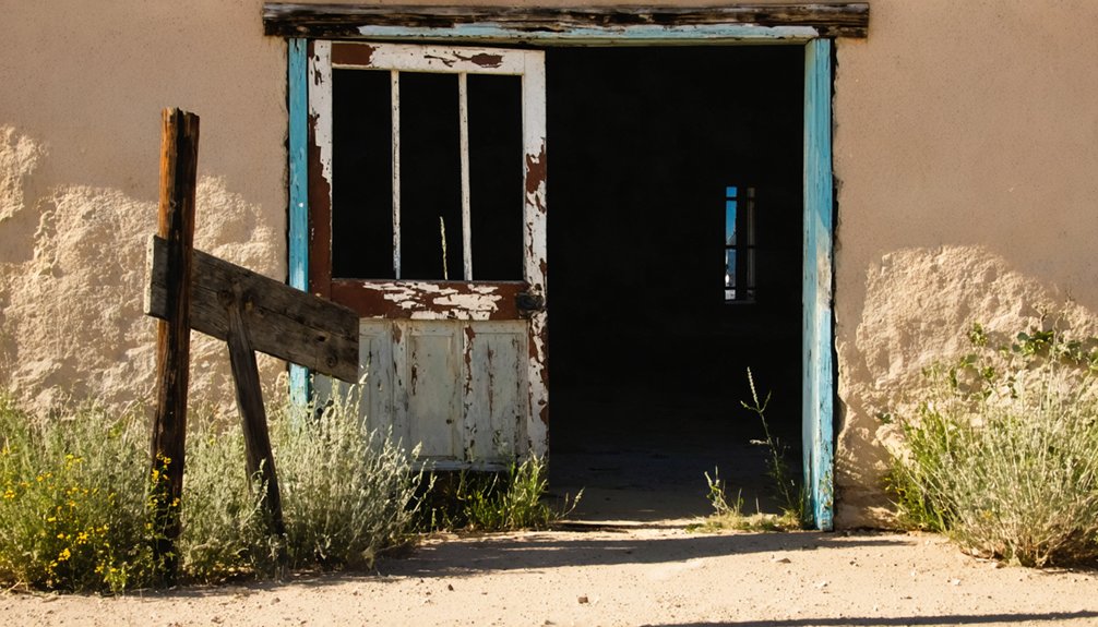
Visiting the Ghost Town Today
As you wander among the crumbling concrete foundations that once supported Cuyamaca City‘s bustling mining operations, you’ll find well-marked hiking trails that connect these historic ruins to the broader Cuyamaca Rancho State Park network.
The remnants of the Stonewall Mine, including equipment footings and the reservoir’s concrete base damaged in the 2003 Cedar Fire, offer compelling photography opportunities against the backdrop of Southern California’s mountain landscape.
You’ll appreciate how the park’s interpretive signage guides you through this California Historical Landmark, revealing the layout of what was once a thriving gold rush community of nearly 500 residents.
Accessible Historic Ruins
Nestled within the pine-oak woodlands of Cuyamaca Rancho State Park, the Stonewall Mine site stands as a tribute to California’s golden past, offering visitors a tangible connection to the region’s mining heritage.
Despite preservation challenges from the devastating 2003 Cedar Fire, you’ll find remarkable ruins that have survived nature’s wrath and time’s passage.
- Foundation remnants of miners’ homes and equipment scattered among the natural landscape
- Mining shafts and artifact scatters that tell stories of 19th-century gold seekers
- The nearby Dyar House ruins, slowly being restored through dedicated volunteer efforts
- Interpretive signage that reveals both mining history and Kumeyaay displacement
Basic visitor amenities include parking, restrooms, and picnic tables, allowing you to explore comfortably while immersing yourself in the authentic remnants of frontier ambition.
Hiking Trail Network
Exploring Cuyamaca’s ghost town today means traversing an extensive network of trails that reveal both history and natural beauty at every turn.
The park offers over 100 miles of well-maintained paths, with the 5.6-mile Cuyamaca Peak Trail providing panoramic vistas through recovering fire-scarred landscapes.
For trail navigation, start at Paso Picacho Campground, where maps and current conditions are available.
The Lookout Fire Road leads to the peak with a moderate 1,700-foot elevation gain, while adventurous hikers might prefer the challenging 7.76-mile Azalea Glen loop.
Wildlife observation opportunities abound, particularly at dawn and dusk.
Watch for acorn woodpeckers, red-tailed hawks, and wild turkeys amid diverse ecosystems ranging from chaparral to coniferous forest.
Remember to carry water, dress in layers, and check pet policies before your journey.
Photography Hot Spots
Photographers flock to Cuyamaca’s ghost town for its remarkable blend of historical remnants and natural beauty, creating a visual storyteller’s paradise.
You’ll find Stonewall Mine‘s 221 preserved cultural features offering authentic compositions of 19th-century mining life. The dramatic post-fire recovery landscapes showcase nature’s resilience through stark contrasts—ideal for experimenting with various photographic techniques.
- Capture Cuyamaca Peak’s sweeping vistas at sunrise, framing shots from Pacific Ocean to Salton Sea
- Document historic Coulter and Cedar Cabins through rustic architectural landscape compositions
- Explore fire recovery zones where charred trees stand against vibrant new growth
- Visit Stonewall Mine’s archaeological remains for compelling historical documentary photography
For ideal lighting, photograph the historical structures during golden hour when shadows accentuate the weathered textures of this once-thriving community’s remains.
Frequently Asked Questions
Were Any Notable Crimes or Murders Reported in Cuyamaca City?
Despite Cuyamaca City’s murder mysteries and crime history research, you’ll find no documented major crimes occurred within city limits. Nearby stagecoach robberies and mining camp violence happened, but the city itself remained relatively untouched.
Did Indigenous Kumeyaay People Work in the Mines?
You’ll find no concrete evidence that Kumeyaay people worked directly in Stonewall Mine. Their contributions likely involved support roles around mining culture, though historical records remain frustratingly silent on this aspect of their history.
What Natural Disasters Affected the Town During Its Existence?
Mountain winds whisper secrets of survival. You’d find no evidence of earthquake impacts or fire destruction in Cuyamaca City’s history. Research shows natural disasters weren’t documented factors in the town’s eventual decline.
Did Any Famous Visitors or Celebrities Ever Visit Cuyamaca City?
You won’t find records of famous visitors or celebrity sightings in Cuyamaca City. Historical research shows the remote mining town attracted miners and settlers rather than prominent figures during its brief existence.
Were There Any Competing Towns Nearby During the Gold Rush?
Like competing gold coins on a map, you’d find several rival settlements nearby—Julian, Branson City, and Stancliff’s development all vied with Cuyamaca City during the intense mining rivalries of the 1870s.
References
- https://www.parks.ca.gov/pages/21299/files/historic background study.pdf
- https://www.sandiegofamily.com/index.php?option=com_content&view=article&id=74:treasure-hunting-in-san-diego&catid=114:family-travel&Itemid=163
- https://sandiegohistory.org/journal/1971/january/cuyamaca/
- https://www.parks.ca.gov/?page_id=25011
- https://www.parks.ca.gov/pages/22491/files/CA_State_Parks_Archaeological_Report_Vol34_Cuyamaca (reduced).pdf
- https://www.latimes.com/archives/la-xpm-1990-11-29-nc-7428-story.html
- https://en.wikipedia.org/wiki/Cuyamaca
- https://en.wikipedia.org/wiki/List_of_ghost_towns_in_California
- https://en.wikipedia.org/wiki/Cuyamaca_Mountains
- http://lastadventurer.com/last-adventurers-fieldnotes/stonewallmine


