
You’ll find Dugway Mine, a remote Utah ghost town, located 57 miles west of Eureka in Tooele County’s Dugway Mountains. Silver-bearing lead-zinc deposits discovered in 1869 sparked the creation of Bullionville settlement and sustained mining operations until 1969. Today, you can explore extensive tailings piles, rusted machinery fragments, and dangerous unmarked mine shafts scattered across this high desert landscape. The site’s isolation and harsh climate have preserved remarkable physical evidence of Utah’s mining heritage that reveals the complete story of this forgotten community.
Key Takeaways
- Located 57 miles west of Eureka in Tooele County, accessible via challenging remote terrain along Pony Express Road.
- Silver-bearing deposits discovered in 1869 led to Bullionville settlement establishment and over 50 years of intermittent mining operations.
- Four Metals Mine was the district’s most significant producer, with peak production occurring during 1934 and 1937-1951.
- Extensive ruins remain including tailings piles, rusted machinery, dangerous unmarked mine shafts with 85-440 foot vertical drops.
- Mining operations ended by 1969 due to rising costs, commodity price declines, and military restrictions affecting access.
Location and Access Requirements
Reaching Dugway Mine Ghost Town requires traversing 57 miles west of Eureka through Utah’s remote Dugway Mountains Mining District in south-central Tooele County.
You’ll navigate challenging terrain along the Deep Creek–Tintic mineral belt within the Basin and Range Province’s distinctive geological features.
Take I-80 west to exit 99 at Tooele, then drive south 40.5 miles on Highway 36. Turn west onto Pony Express Road for 50.1 miles—this remote stretch demands careful preparation.
Essential navigation tips include using GPS coordinates N 39° 51′ 23.7924″, W 113° 27′ 21.9384″ and carrying Fish Springs 1:100,000 or Dugway Pass 1:24,000 topographic maps. Online mapping tools allow you to input these latitude and longitude coordinates directly to center your digital maps before departure.
GPS coordinates N 39° 51′ 23.7924″, W 113° 27′ 21.9384″ and detailed topographic maps are essential for navigating this remote terrain.
Expect dirt roads without signage and plan for a 2-hour, 45-minute drive from Salt Lake City through rugged backcountry.
Climate and Best Visiting Times
Once you’ve successfully navigated the challenging route to Dugway Mine Ghost Town, understanding the area’s high desert climate becomes essential for planning your exploration.
the history of upper kanab ghost town adds an intriguing layer to your visit, as it reveals the stories of those who once called this remote area home. Exploring remnants of old structures and artifacts can enhance your understanding of the challenges faced by early settlers. Be sure to take your camera, as the ghost town’s eerie beauty against the backdrop of the landscape offers stunning photo opportunities.
This remote location experiences moderate high desert climate patterns with annual temperatures averaging 51.3°F, ranging from 16°F to 94°F.
Summer brings intense heat with July highs reaching 96°F, though low humidity at 59% makes daytime conditions manageable.
Winter proves harsh with January lows dropping to 14°F and light snowfall averaging 17 inches annually.
Seasonal temperatures vary dramatically with 40°F daily swings common. The area’s prevailing winds shift predictably from northwest during afternoons to southeast during nights and mornings.
You’ll find late spring through fall ideal for visiting. May offers comfortable 75°F highs, while September averages 82°F.
Annual precipitation remains minimal at 6-8 inches, mostly occurring during spring months. The region receives approximately 8.62 inches of rainfall annually based on climate data.
Historical Development and Early Settlement
When you explore Dugway’s origins, you’ll find that prospectors first discovered silver-bearing lead-zinc deposits in 1869, just one year before the more widely documented 1870 silver strike that sparked serious development.
The initial mineralization discoveries led directly to the establishment of early prospecting camps in the northern Dugway Range, where accessible outcrops and seasonal water sources supported small-scale operations. By 1872, the mining district was formally organized as the Dugway Mountains Mining District, providing administrative structure for the growing number of claims and operations in the area.
The location’s strategic position in the Great Salt Lake Desert made it particularly valuable for both mining operations and transportation, as the area offered significant advantages for moving ore and supplies across the challenging desert terrain.
Silver Discovery in 1870
The year 1870 marked a pivotal moment for the remote Dugway Range when prospectors made the first documented silver discovery in the area’s sandstone formations.
Unlike traditional silver veins found in quartz, you’d encounter horn silver and other silver chlorides concentrated in weathered sandstone outcrops. This discovery differed markedly from conventional mineral extraction methods since the ore occurred in patchy lenses rather than continuous veins.
The find immediately sparked intense interest across the region, prompting rapid claim staking throughout the Dugway Range. Early prospectors faced widespread disbelief from established mining communities who considered silver in sandstone geologically impossible.
You’ll find this discovery aligned with Utah’s broader 1870s silver boom, which included similar sandstone-hosted deposits like Silver Reef. The mineralization contained silver with subordinate lead, creating multiple small occurrences that attracted prospectors seeking their fortunes in Utah’s expanding mining frontier. Following the initial discovery, miners established Bullionville settlement to support the growing operations and house the influx of workers drawn to the promising silver deposits.
Bullionville Camp Establishment
Following the initial silver discoveries, John H. Ely and W.H. Raymond quickly recognized the opportunity in Meadow Valley’s mining potential. In February 1870, they relocated their five-stamp mill from Hiko to establish what would become Bullionville.
You’ll find this strategic move positioned the camp perfectly near Pioche’s mining activities, creating an essential processing center for regional ore.
The Raymond & Ely partnership drove rapid infrastructure development, focusing on milling operations that would anchor the Bullionville economy. Their site selection prioritized proximity to ore sources and accessibility for efficient transport. The settlement’s access to water sources proved crucial for establishing the multiple mills that would define Bullionville’s industrial character.
Camp logistics flourished as peddlers from Utah counties supplied hay, grain, flour, and lumber to meet growing demand. This positioning made Bullionville an indispensable supply hub, connecting Nevada’s mining camps with Utah’s agricultural resources and establishing its role in the broader mining district. During the Great Depression era, the camp would later serve as home to CCC men who contributed to regional conservation efforts.
Mining Operations and Key Properties
Discovery of mineral deposits in the Dugway and Thomas Ranges during the late 19th century launched intermittent mining activities that would span more than half a century.
You’ll find the Four Metals Mine stands as the district’s most significant producer, with documented ore shipments and substantial underground workings including headframes captured in historical field reports. The Rainbow Mine ranks as another principal operation, repeatedly mentioned in regional mineralization studies.
The area’s mineral diversity included gold, silver, copper, lead, and zinc deposits within quartz-calcite vein systems. The completion of the transcontinental railroad in 1869 transformed mining operations from small-scale ventures to commercial enterprises throughout Utah’s mining districts.
Rich veins of gold, silver, copper, lead, and zinc formed within distinctive quartz-calcite geological systems throughout the mining district.
Peak production occurred during 1934 and 1937-1951, when extraction techniques focused on underground mining methods.
Multiple smaller prospects and claims dotted the landscape, though none matched the sustained output of major Utah mining districts.
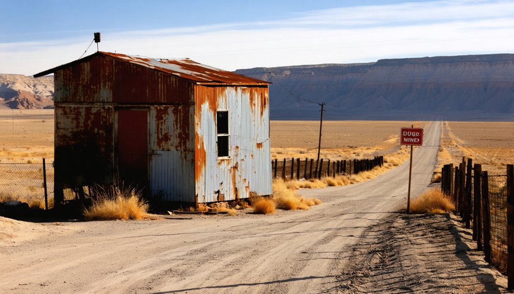
Current Remains and Physical Evidence
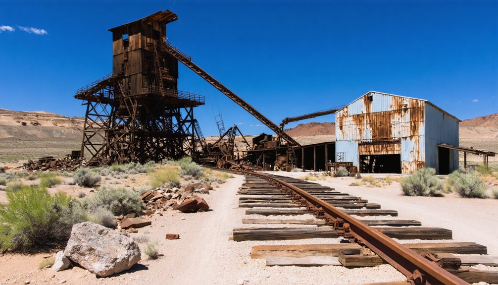
You’ll find extensive tailings piles and disturbed spoil heaps scattered around the former working areas, marking where miners once disposed of ore waste.
Rusted machinery fragments including gears, pulleys, and bearing housings lie among the surface debris, alongside corroded tanks and metal vats that processed ore on-site.
Exercise extreme caution when exploring, as dangerous mine shafts remain unmarked and unprotected throughout the area.
Visible Tailings and Debris
Scattered across Dugway’s landscape, thousands of tons of displaced overburden form conspicuous light-colored mounds that mark the ghost town’s commercial mining operations.
These tailings piles reveal the scale of excavation—BLM documents show single pits displaced approximately 3,800 tons over their operational life. You’ll find loose sediment stockpiles composed of lake-deposited materials and rhyolitic clay typical of Dugway’s geode beds.
The visible debris tells the story of commercial extraction:
- Geode fragments and host-rock rubble scattered across spoil pile surfaces, evidence of screening operations
- Hummocky, backfilled terrain where tailings were pushed to pit edges as safety berms
- Linear spoil lines extending along excavation benches and access roads
Surface disturbance concentrates around two main pits, where you can still identify intact geodes among the scattered mining refuse.
Scattered Mining Equipment
Rusted machinery and abandoned equipment mark Dugway’s mining sites like mechanical fossils embedded in the desert landscape.
You’ll discover old pickup trucks and flatbed chassis stripped of engines and wheels, alongside tracked earthmoving equipment fragments scattered throughout the area. Corroded fuel tanks and drums puncture the silence, bearing witness to decades of exposure.
Crushing equipment remnants, including jaw crusher frames and stone hoppers, stand as evidence to the site’s processing operations. Historical artifacts like stamp mill components and ore-sorting table remains dot the terrain.
Hand tools—sledgehammers, picks, and shovels—lean against surviving timbers, while drill bits and electrical components from early generators complete this mechanical graveyard of mining ambition.
Dangerous Mine Shafts
Beyond the scattered equipment lies Dugway’s most lethal legacy—a network of unprotected mine shafts that plunge hundreds of feet into darkness.
These vertical drops reach depths of 85 to 440 feet, creating deadly fall hazards for anyone exploring the area. You’ll find most openings lack basic shaft safety features like handrails or secured grates.
The immediate dangers you’ll encounter include:
- Deteriorated covers – Rusted rebar and rotting wooden planks that collapse under weight
- Hidden depths – Shallow-appearing openings that extend into complex underground voids
- Toxic atmospheres – Oxygen-deficient “black damp” and poisonous gases in enclosed shafts
What makes these shafts particularly treacherous is their deceptive nature.
Surface collapses often mask the true depth beneath loose material, turning seemingly minor hazards into fatal traps.
Decline and Military Restrictions
The economic impact proved devastating.
Road closures increased travel distances, while periodic testing shutdowns made reliable access impossible. Rising operational costs, combined with marginal ore grades and commodity price declines, made continued mining uneconomical by the postwar decades.
Labor shortages accelerated as workers left remote camps. By 1969, the district’s modest lead-zinc production had dwindled to intermittent operations, effectively ending Dugway’s mining era.
Frequently Asked Questions
Are There Any Safety Precautions Needed When Exploring the Old Mine Shafts?
You’re entering nature’s death trap when exploring mine shaft safety becomes critical. Exploration hazards include structural collapse, toxic gases, and disorientation. You’ll need proper gear, backup plans, and never venture alone into these deteriorating underground labyrinths.
What Permits or Permissions Are Required to Visit the Ghost Town?
You don’t need permits to visit since it’s on BLM public land with free access. Follow standard visitor guidelines for rockhounding—stay under daily collection limits and avoid using power equipment during exploration.
Can Visitors Collect Mineral Specimens or Artifacts From the Site?
Like treasure hunters facing locked vaults, you can’t collect artifacts from this military-controlled site. However, you’re free to pursue mineral collecting at nearby BLM geode beds for artifact preservation purposes.
Are There Any Guided Tours or Maps Available for the Area?
You won’t find official guided tours for this remote location, but there’s basic signage at Dugway Geode Beds parking area. The historical significance attracts independent rockhound guides who occasionally offer informal assistance to visitors.
What Should Visitors Bring for Supplies and Emergency Preparedness?
You’ll need first aid supplies, extra water, essential gear like spare tires and tools, plus emergency communications equipment. Remote desert locations require self-reliance – bring navigation tools, food, and vehicle repair supplies for safety.
References
- https://www.ghosttowns.com/states/ut/dugwaymine.html
- https://www.jstor.org/stable/j.ctt4cgn2r.8?Search=yes&resultItemClick=true&searchText=au:&searchText=”F.”&searchUri=/open/search/?theme=open&page=32&so=new&Query=au%3A%22F.%22&si=1
- https://marigoldmoose.com/tag/ghost-towns/
- https://www.youtube.com/watch?v=8wXxTiOkqKU
- https://expeditionutah.com/ghosttowns/
- https://www.youtube.com/watch?v=FRzL1EseXQ8
- https://freepages.history.rootsweb.com/~gtusa/usa/ut.htm
- https://www.blm.gov/visit/dugway-geode-beds
- https://www.findlatitudeandlongitude.com/l/Utah+Mine
- https://www.mindat.org/loc-37463.html


