You’ll find that El Dorado began as Mud Springs, a natural watering hole discovered by emigrants in the late 1840s that became California’s richest placer mining center. The area’s population exploded from 14,000 to over 250,000 during the Gold Rush, creating multicultural boomtowns before devastating floods in 1859 and 1862 obliterated settlements like Eldoradoville. Economic boom-and-bust cycles, the Great Depression, and highway development led to final abandonment when the post office closed in 1955, though preservation efforts since the 1960s have maintained historical remnants.
Key Takeaways
- El Dorado originated from Mud Springs, a natural watering hole for emigrants that became a Gold Rush mining camp in the 1840s-1850s.
- Both towns experienced massive population booms during California’s Gold Rush, with El Dorado County housing one-fifth of California’s white population by 1850.
- Devastating floods in 1859 and 1862 destroyed towns like Eldoradoville, leading to permanent abandonment with no reconstruction attempts.
- Economic decline followed boom-and-bust mining cycles, with the final post office closure occurring in 1955 after postwar automobile travel changes.
- Preservation efforts since the 1960s have stabilized historic remnants through California Historical Landmark designation, though private ownership complicates protection.
Gold Rush Origins and Early Settlement at Mud Springs
When emigrants and freight teams first encountered the natural spring along the Sacramento-Hangtown route in the late 1840s, they found a convenient watering hole that livestock quickly trampled into a muddy morass, earning the site its original name of Mud Springs.
You’ll discover this natural water source became essential for overland travelers heading between Sacramento and Placerville during California’s Gold Rush.
The springs’ strategic location made it an inevitable camping and resupply point for miners seeking fortune in nearby placer diggings. By 1851, the growing community’s importance was officially recognized when a post office was established, marking the formal development of the settlement. The area would later transform into El Dorado, becoming the center of rich placer diggings that attracted prospectors from across the region.
Population Boom and Economic Foundation in the 1850s
You’ll find that El Dorado County’s population explosion during the 1850s made it home to over one-fifth of California’s white population by 1850, representing one of the state’s highest concentrations of Gold Rush migrants.
The tens of thousands who arrived during 1849-1850 created an economic foundation built entirely around placer mining operations, with Shingle Springs and surrounding settlements developing support industries from blacksmith shops to boarding houses that served the overwhelmingly male mining workforce.
Census records from this decade reveal how quickly these mining camps transformed from temporary tent settlements into established towns with permanent commercial districts, even as the county’s proportional share of California’s population began declining due to statewide dispersal of migrants. These settlements flourished in the county’s characteristic rolling hills, which became dotted with mining claims and supporting infrastructure. This rapid settlement contributed directly to California achieving statehood in 1850, marking the region’s swift transition from frontier territory to an integral part of the expanding United States.
Gold Rush Settlement Surge
As gold discoveries transformed California’s demographic landscape, the non-Indigenous population exploded from roughly 14,000 in 1848 to over 250,000 by 1852, fundamentally reshaping settlements like El Dorado and Shingle Springs.
You’ll find that approximately 300,000 people arrived during this era, creating multicultural boomtowns that’d eventually contribute to ghost town culture.
San Francisco’s growth from 1,000 to 36,000 residents served as the primary gateway, while El Dorado County’s Sierra Nevada foothills witnessed dozens of new mining camps emerge practically overnight. The region’s rapid transformation was driven by gold output that peaked at $60 million annually by 1855, creating unprecedented economic opportunities. San Francisco became such a dominant commercial center that only London had more newspapers at the height of the gold rush.
These weren’t family settlements—they were populated by single, working-age men pursuing prospecting opportunities and developing mining innovations that’d define the region’s character.
- Chinese immigrants comprised tens of thousands of arrivals by 1852
- Indigenous population declined sharply from ~110,000 due to displacement
- Tent camps frequently evolved into permanent towns with sustainable services
- Californios were rapidly marginalized by Anglo settler expansion
- Ghost-town trajectories began when surface gold depleted mid-1850s
Mining Camp Economic Engine
While surface panning initially dominated the gold extraction process in El Dorado and Shingle Springs, the economic foundation of these mining camps rapidly evolved into sophisticated operations that’d sustain populations well beyond the initial prospecting phase.
You’d witness individual miners gradually replaced by joint-stock companies investing in hydraulic mining technology and stamp mills for quartz vein extraction.
The economic engine expanded beyond gold extraction to include sawmills producing 16,000 shingles daily, freight operations, and water delivery systems. Travelers found essential stopping points along the Carson Emigrant Trail, where establishments like Shingle Spring House and Missouri House provided crucial services to emigrants making their westward journey.
General stores extended credit tied to miners’ yields, while blacksmiths, wheelwrights, and millwrights formed secondary industries. The region’s proximity to Sutter’s Mill reinforced its position as a central hub in California’s gold rush economy.
Capital flowed into transportation infrastructure and ancillary businesses like hotels and saloons, creating a diversified economic base that supported continuous workforce operations throughout the 1850s mining boom.
Census Records Population Data
Two major census counts captured the extraordinary demographic transformation of El Dorado County during the height of California’s gold rush.
You’ll find that California’s population exploded from 92,597 in the 1850 federal census to 260,949 in the 1852 state census, reflecting the massive influx of fortune seekers. This demographic change represents one of America’s most dramatic population booms, with 300,000 people arriving between 1848 and 1854.
The rapid growth and constant miner mobility seriously questioned census accuracy during this turbulent period. El Dorado County’s formation on February 18, 1850, coincided perfectly with this unprecedented migration. These historical population records now serve as invaluable genealogical research tools for descendants tracing their family histories. Modern researchers can access these records through online platforms like Ancestry.com and other digital genealogical databases.
- 1850 federal census began June 1st, completed within five months
- State census mandated by 1849 California constitution for population tracking
- El Dorado County shows 44 records in 1850, expanding to 57 by 1860
- Census questions covered occupation, real estate value, and racial classifications
- Missing counties in 1852 included Colusa, Sutter, and Marin
Eldoradoville’s Rise and Catastrophic Destruction
You’ll find Eldoradoville’s story represents one of California’s most dramatic boom-to-bust mining tales, where hydraulic gold extraction transformed a simple prospector camp into a thriving shantytown along the East Fork of San Gabriel River during the 1850s-1860s.
The settlement’s precarious riverbank location, while providing access to rich gold deposits, exposed residents to catastrophic flood risks that would repeatedly devastate mining operations.
Two major flood events—first in November 1859, then the catastrophic January 1862 cloudburst—ultimately erased this once-prosperous mining district from existence, leaving only scattered foundations as evidence of its former glory.
Boom Town Origins
Before the devastating flood that would erase Eldoradoville from the map, the settlement’s origins traced back to modest beginnings along the East Fork of the San Gabriel River, where early prospectors scraped together mere cents per pan until 1859’s transformative discovery. That breakthrough elevated daily yields to six or seven dollars per miner, triggering the gold rush that birthed Eldoradoville.
You’ll find the boom town’s foundation built on technological advancement and entrepreneurial spirit. Advanced mining technology including sluices, long toms, and hydraulic operations replaced primitive panning methods, generating thousands monthly.
- Water wheels and elaborate dam systems powered sophisticated extraction operations
- Teams of 10-20 miners worked organized claims under experienced leadership
- $80,000 worth of gold shipped to Philadelphia during peak production
- Six saloons provided gambling and entertainment for dense prospector population
- 27 mining regulations governed the Eldoradoville Mining District boundaries
Devastating Flood Events
While Eldoradoville’s miners celebrated unprecedented prosperity in 1859, nature was already preparing the catastrophic forces that would twice reshape their destiny along the East Fork of the San Gabriel River.
The November 1859 flood demolished mining works with tremendous force, sweeping away dams, waterwheels, and sluices throughout San Gabriel Canyon.
Yet you’d witness remarkable flood recovery as miners rebuilt within a month, establishing Eldoradoville as the “Downieville of the South” by March 1860.
However, the environmental impact intensified when torrential rains struck January 17-18, 1862, part of California’s largest recorded flood.
A wall of churning gray water obliterated Eldoradoville completely, forcing residents up hillsides as debris—shacks, whiskey barrels, roulette wheels—swept downstream, ending the East Fork’s boom forever.
Final Town Abandonment
After the devastating 1859 flood, Eldoradoville’s miners demonstrated extraordinary resilience by rebuilding their settlement within a month, transforming it into what contemporaries called the “Downieville of the South.”
The mining district’s formal establishment on March 10, 1860, marked the beginning of an unprecedented boom period when hydraulic gold extraction operations flourished throughout San Gabriel Canyon’s East Fork.
However, the January 17-18, 1862 torrential cloudburst sealed this ghost town’s fate with absolute finality concept. You’ll find no survivors attempted reconstruction after that catastrophic wall of churning gray water obliterated everything.
- Complete erasure – shacks, whiskey barrels, roulette wheels swept to San Gabriel floodplain
- One miner, mule, gold sacks, and safe vanished forever
- No photographs or sketches survived the destruction
- Only stone foundations remain after 4-5 hour hike
- Bridge to Nowhere stands 250 feet above former settlement site
Ethnic Diversity and Mining Camp Communities
As thousands of fortune-seekers descended upon El Dorado and Shingle Springs during the 1849–1851 Gold Rush, the mining camps evolved into remarkably diverse communities that reflected the global nature of California’s mineral boom.
You’ll find evidence of distinct ethnic cohesion patterns throughout these settlements, where Chinese, Mexican, Chilean, and European immigrants clustered in separate neighborhoods along gulches and creeks.
While Anglo-American miners dominated initial claims and capitalized operations, labor dynamics shifted as deposits were exhausted. Chinese miners reworked abandoned tailings, Latin Americans operated small-scale placers, and skilled Europeans managed stamp mills.
Despite legal discrimination and higher mining fees targeting foreign workers, these communities developed parallel institutions—ethnic stores, boarding houses, and mutual aid societies that sustained diverse populations long after the initial rush subsided.
Recurrent Floods and Fire Disasters
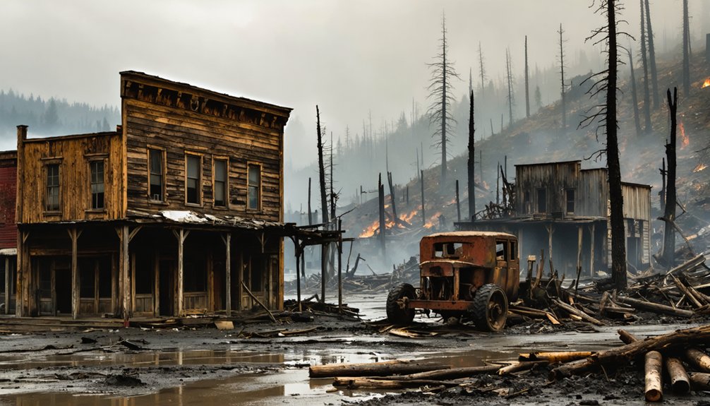
You’ll discover that El Dorado and Shingle Springs faced devastating natural disasters that repeatedly destroyed infrastructure and displaced residents throughout their mining era.
Historical records document catastrophic floods during winter storms that washed away buildings, mining equipment, and entire sections of these communities, while summer fire disasters consumed wooden structures and forced complete evacuations.
These recurrent disasters created cycles of destruction and reconstruction that ultimately contributed to the towns’ abandonment as residents grew weary of constantly rebuilding their lives and businesses.
Catastrophic Flood Damage
While El Dorado County‘s mountainous terrain and creek systems create scenic landscapes, they’ve also subjected the region to devastating flood cycles that have claimed lives and destroyed millions of dollars in property over more than a century.
Historical records reveal catastrophic patterns dating back to 1867’s flash flooding in nearby regions. The 1963 floods alone killed 10 people and caused $18.5 million in damage across Sierra Nevada basins.
Sacramento region’s repeated flooding in 1986, 1995, 1997, 2006, and 2017 demonstrates ongoing regional vulnerability. You’ll find flood prevention efforts increasingly challenged by climate shifts that concentrate precipitation into shorter, more intense periods, overwhelming natural drainage systems and existing infrastructure.
- 12,009 El Dorado County properties face flood risk over the next 30 years
- Reduced Sierra Nevada snowpack eliminates natural water storage capacity
- Atmospheric rivers combined with rapid snowmelt create perfect storm conditions
- Natural slopes and creek proximity amplify runoff during storm events
- Disaster recovery becomes increasingly complex as flood frequency intensifies
Major Fire Destruction
Beyond the devastating floods that have plagued El Dorado County, fire disasters have repeatedly reshaped the region’s communities through both industrial accidents and massive wildfires.
You’ll find records of the 1923 California Door Company fire in Diamond Springs, which spread from industrial structures into the surrounding community, destroying homes and businesses. Early lumber operations created concentrated ignition sources that threatened settlements like Caldor.
More recently, you’ve witnessed the catastrophic Caldor Fire of 2021, which burned 221,775 acres and forced 50,000 evacuations while destroying nearly 800 structures.
These disasters transformed local fire safety protocols and urban planning approaches. Industrial fires historically catalyzed regulatory changes, establishing formal fire districts and building codes that now protect communities throughout the Sierra Nevada foothills.
Town Rebuilding Efforts
When examining the cyclical nature of disaster recovery in El Dorado County, you’ll discover that rebuilding efforts have evolved from reactive emergency measures to thorough resilience planning.
Sacramento Area Flood Control Agency’s designation of the region as having America’s greatest metropolitan flood risk catalyzed extensive flood management strategies. Following the devastating 2006 storms, residents developed heightened vigilance and personal preparedness protocols.
- Businesses now proactively deploy sandbags before predicted storms rather than waiting for emergency warnings.
- County officials implemented Climate Vulnerability Assessment programs addressing temperature and precipitation changes.
- Communities established monitoring systems for king tides, reservoir releases, and watershed runoff patterns.
- Emergency response protocols evolved from basic sandbagging to sophisticated early warning networks.
- Local governments prioritized community resilience through infrastructure improvements and public education initiatives.
Violence and Lawlessness in the Mining Fields

As formal legal institutions struggled to establish themselves in the remote mining camps of El Dorado County, miners took justice into their own hands through vigilante committees that dispensed swift and often brutal punishments.
You’d witness summary trials followed by immediate hangings for alleged theft or murder, with newspapers documenting multiple mob executions throughout the 1850s.
Ethnic violence targeted Chinese and Indigenous peoples through organized massacres and systematic dispossession.
Mining conflicts erupted over claim disputes, as “claim jumping” provoked armed confrontations and retaliatory killings.
Saloon owners and mining gangs provided informal enforcement when official law enforcement remained absent.
These cycles of violence created an atmosphere where you’d find communities operating outside legal frameworks, delegating authority to ad hoc groups with little oversight.
Boom-and-Bust Economic Patterns
The lawlessness that plagued El Dorado County’s mining camps reflected deeper economic instabilities that would define the region’s character for decades.
You’ll discover how El Dorado and Shingle Springs exemplified California’s brutal economic cycles, where fortunes vanished as quickly as they appeared.
When surface gold disappeared by the mid-1850s, these once-thriving communities couldn’t adapt to capital-intensive deep mining operations controlled by distant corporations.
The shift from individual prospecting to mechanized extraction concentrated wealth among fewer players, leaving most residents behind.
As mining became industrialized, wealth flowed upward to corporate owners while ordinary prospectors found themselves economically displaced.
Community resilience proved fragile when economic foundations crumbled, transforming bustling settlements into abandoned shells within years.
- Placer gold yields plummeted from tens of millions annually to marginal returns
- Capital requirements for hydraulic mining excluded independent prospectors completely
- Corporate consolidation centralized profits away from local communities
- Environmental regulations banned profitable hydraulic methods, devastating town economies
- Transport improvements initially boosted growth but couldn’t sustain resource-depleted areas
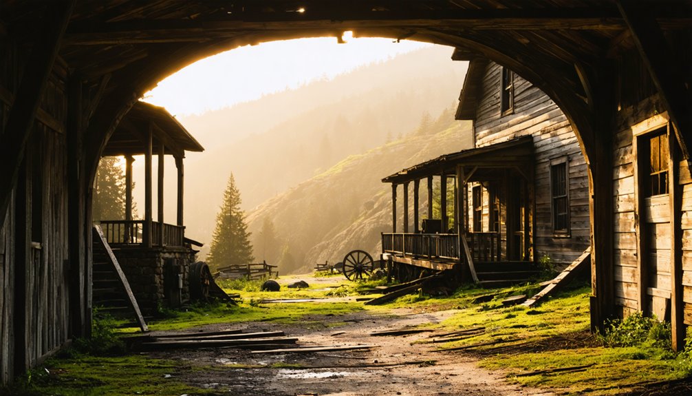
Physical Remnants and Archaeological Evidence
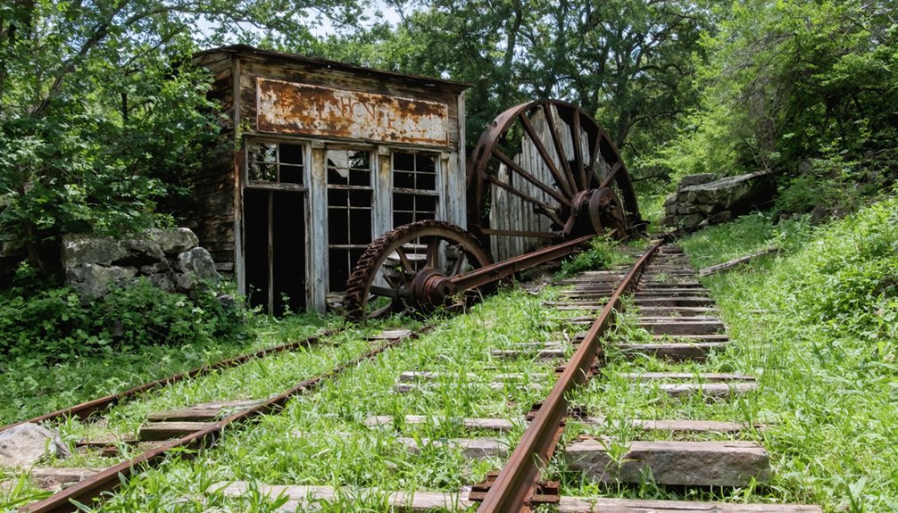
Scattered foundations and weathered stone walls mark where El Dorado and Shingle Springs once bustled with Gold Rush commerce, their physical remnants serving as tangible links to California’s most dramatic economic transformation.
You’ll find Wells Fargo building shells constructed from native stone with characteristic arched openings, alongside miner cabin ruins dotting the landscape.
Archaeological findings reveal concentrated artifact horizons beneath surface vegetation, where shovel tests uncover 19th-century occupation layers filled with ceramic sherds, glass fragments, and mining tools.
Historical artifacts recovered from placer gulches include sluice riffles and rocker parts, while domestic middens yield datable material culture.
You can trace original wagon ruts from Sacramento-Placerville routes, and hydraulic mining scars permanently altered stream channels, creating persistent geomorphic features that document intensive resource extraction across El Dorado County’s historic mining zones.
Depression Era Revival and Final Abandonment
When the Great Depression struck California’s foothills in 1929, El Dorado and Shingle Springs had already declined from their Gold Rush zenith to scattered ranching operations and waystation commerce along the Sacramento-Placerville route.
Depression impacts initially worsened conditions as agricultural prices plummeted and transport diminished. However, revival efforts through New Deal programs brought unexpected rejuvenation during the 1930s.
Federal initiatives targeted rural infrastructure improvements:
- Civilian Conservation Corps projects upgraded local roads and facilities
- Works Progress Administration funded community buildings and utilities
- Agricultural subsidies supported struggling ranching operations
- Relief workers created temporary population influx
- Wartime proximity to Sacramento boosted supply chain logistics
World War II delayed final abandonment through increased ranching output and defense industry connections.
Yet postwar automobile travel and highway expansion ultimately sealed the towns’ fate, culminating in official post office closure in 1955.
Preservation Efforts and Modern Site Access
Although decades of neglect threatened to erase El Dorado and Shingle Springs entirely, preservation efforts since the 1960s have stabilized key remnants and established frameworks for ongoing stewardship.
You’ll find California Historical Landmark designation provides interpretive signage, though regulatory protection remains limited. The El Dorado County Historical Society actively collects artifacts and photographs essential for preservation planning. Local groups pursue legal advocacy and participate in county review processes affecting historic resources.
Physical preservation techniques include structural stabilization of surviving stonework and foundations, plus artifact relocation to controlled museum environments.
Community engagement drives volunteer-led restoration projects and annual fundraising events supporting cemetery restoration. However, private landownership covering most historic townsites restricts public protection options, shifting preservation responsibility to individual owners and dedicated historical societies working within available resources.
Frequently Asked Questions
What Happened to Shingle Springs During the Gold Rush Era?
You’d think freedom-seekers would’ve learned, but gold discoveries transformed Shingle Springs into a bustling mining hub by 1850. Mining impact brought $200-per-day claims, infrastructure development, then inevitable decline when deposits vanished.
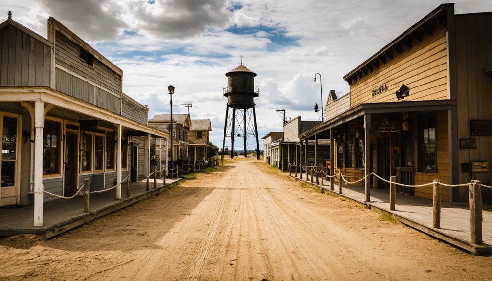
Are There Any Guided Tours Available for El Dorado Ghost Towns?
You’ll find guided tour options through El Dorado County Museum offering free Wednesday-Sunday tours, plus Fountain & Tallman Museum’s Main Street walks. Local tour guides provide historic exploration with period costumes and archival storytelling.
Can Visitors Legally Metal Detect or Collect Artifacts at These Sites?
Like traversing a legal minefield, you can’t metal detect without permits due to strict metal detecting regulations protecting archaeological resources. Artifact preservation concerns mean violations carry serious penalties under state and federal laws.
What’s the Best Time of Year to Visit These Ghost Town Locations?
You’ll find autumn offers ideal conditions with cooler temperatures, stunning foliage, and enhanced atmospheric exploration. Weather considerations include avoiding winter’s wet conditions and summer’s heat, while seasonal attractions like harvest events complement ghost town visits perfectly.
How Do El Dorado’s Ghost Towns Compare to Other California Mining Settlements?
You’ll find El Dorado’s ghost towns demonstrate greater historical significance than most California mining settlements, featuring exceptional mining heritage preservation, higher mine density, and longer-lasting communities due to diversified commerce beyond single-pit operations.
Exploring abandoned mining towns in California reveals the stories of those who lived and worked there, offering a glimpse into a bygone era. Many of these towns contain remnants of old buildings, artifacts, and the remnants of bustling life that once thrived in the gold rush. Visitors to these sites often find not just a sense of history, but also stunning landscapes that tell the tales of perseverance and decline.
References
- https://www.legendsofamerica.com/ca-volcanoville/
- https://www.youtube.com/watch?v=Egy9mMTVKmo
- https://eldoradolibrary.org/museum-county-history/
- https://www.pbssocal.org/shows/departures/eldoradoville-the-forgotten-boom-town-of-the-san-gabriels
- https://visit-eldorado.com/historic-towns/
- https://nvtami.com/el-dorado-county-california-ghost-towns/
- https://www.stylemg.com/2017/04/25/140586/in-history-el-dorado-county-ghost-town-clarksville
- http://goldrushchronicles.com/eldorado.htm
- https://www.youtube.com/watch?v=YAnKn3xhTVY
- https://www.hmdb.org/m.asp?m=11571


