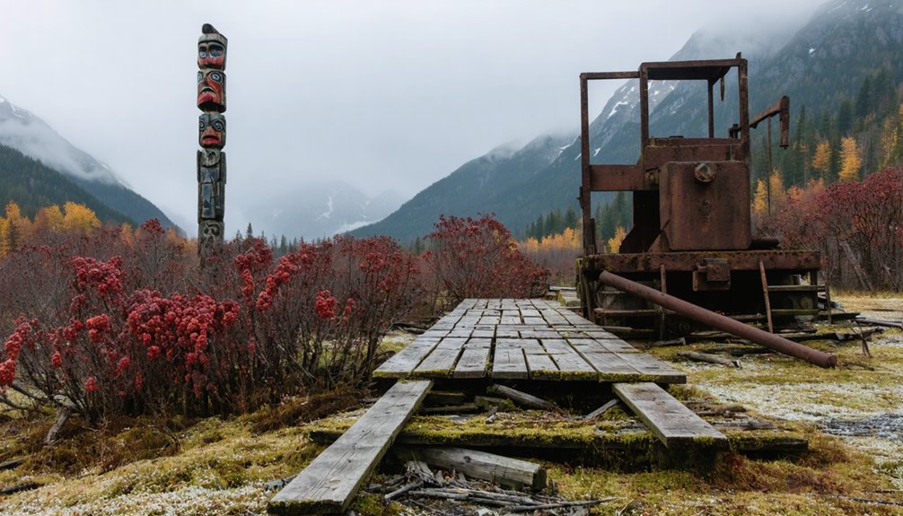
You’ll discover Alaska’s most famous ghost towns include Kennicott, where copper miners extracted $200 million worth of ore from 1911-1938 before abandoning the entire operation. Portage became a haunting ruin after the 1964 magnitude 9.2 earthquake dropped the town below sea level, creating a ghost forest. Ukivok on King Island showcases thousand-year-old Inupiat stilt houses clinging to dramatic cliffs, while Treadwell’s gold mining ruins and Dyea’s Klondike gateway remnants complete Alaska’s abandoned settlement legacy that continues below.
Key Takeaways
- Kennicott was the world’s copper mining capital from 1911-1938, generating nearly $200 million before abandonment.
- Portage became a ghost town after the 1964 magnitude 9.2 earthquake dropped it below tide level.
- Ukivok on King Island features ancient Inupiat stilt houses on 45-degree cliffs, abandoned in the 1960s.
- Treadwell was a major gold mining operation that ended dramatically in 1917 due to catastrophic cave-ins.
- Dyea served as a Klondike Gold Rush gateway town with 3,500 residents before railroad completion caused decline.
Kennicott: The Copper Mining Capital of the World
When prospectors Clarence Warner and Jack Smith spotted green malachite outcropping on Bonanza Peak along Kennecott Glacier in summer 1900, they’d discovered what would become the richest copper concentration ever found.
Their ore samples revealed 70% pure chalcocite, launching Kennecott history as Alaska’s most lucrative mining operation.
Stephen Birch bought out the original prospectors for $275,000, then secured backing from the powerful Guggenheim and Morgan families.
Stephen Birch transformed a $275,000 prospector buyout into millions through strategic partnerships with America’s most powerful financial dynasties.
They invested $25 million building a complete infrastructure including mines, mills, and a 196-mile railroad.
Mining techniques were remarkably simple—workers shoveled high-grade ore directly into shipping sacks without processing. The operation also produced significant amounts of silver content, averaging 14 ounces per ton alongside the copper extraction.
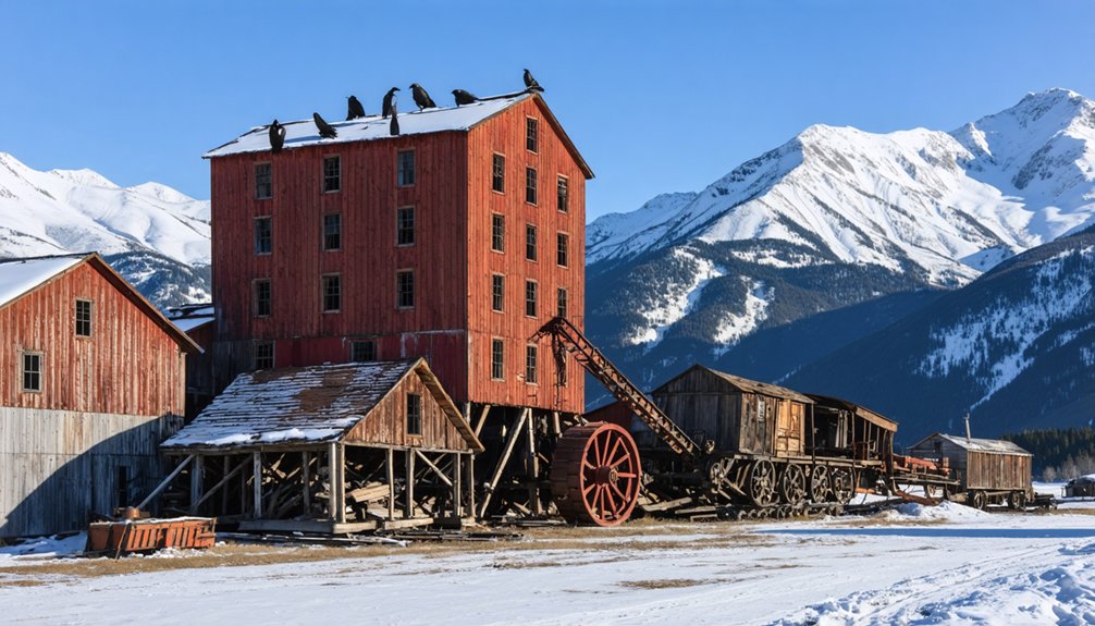
From 1911-1938, you’d have witnessed peak production yielding nearly $200 million worth of copper, making this remote wilderness Alaska’s temporary copper capital. The Kennecott Historic Mill, where all the extracted copper was processed before transport, still stands today with much of its original machinery intact.
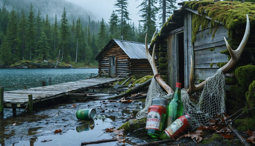
Portage: A Town Destroyed by Nature’s Fury
You’ll find Portage’s story differs from other Alaskan ghost towns because nature, not economics, sealed its fate.
On Good Friday, March 27, 1964, at 5:36 p.m., a magnitude 9.2 earthquake—the largest in U.S. history—struck for nearly five minutes and dropped the ground 6-12 feet below high tide level. Saltwater from Cook Inlet flooded the town after the earthquake, forcing all residents to evacuate.
The disaster claimed 139 fatalities from both the earthquake and the tsunamis it generated across the region.
What remains today serves as a haunting monument to the earthquake’s devastating power, with skeletal ruins and a ghost forest marking where this transportation hub once thrived.
1964 Earthquake Devastation
On Good Friday, March 27, 1964, at 5:36 p.m. local time, the second-largest earthquake in recorded history struck Alaska with a devastating magnitude of 9.2.
For nearly five minutes, you’d have witnessed the earth literally tearing apart beneath Portage. Ground blocks moved like massive elevators, rising and plunging unpredictably. Cracks opened and closed, spouting muddy water fifty feet high. The town sank six to ten feet below Cook Inlet’s high tide level while nearby areas rose thirty feet.
Buildings collapsed from relentless shaking as saltwater flooded everything. The earthquake aftermath created a ghost forest when salt killed every tree. The liquefaction of soft soils beneath the town caused this dramatic sinking, illustrating the particular vulnerability of areas built on unstable ground.
Despite Alaska’s natural resilience, Portage couldn’t survive this catastrophe. You’ll find no rebuilding efforts occurred—residents evacuated permanently, abandoning their community to nature’s overwhelming power. Today, the area is located 47 miles south of Anchorage near Turnagain Arm on the Seward Highway.
Ruins as Monuments
Today’s skeletal remains of Portage stand as haunting monuments to nature’s destructive power along the Seward Highway, forty-seven miles south of Anchorage.
You’ll discover townsite remnants scattered throughout the marsh, where structural foundations of home sites persist despite decades of saltwater exposure. The ghostly landscapes showcase ashen tree trunks rising from mud, creating an eerie forest of dead timber killed by Cook Inlet’s saltwater intrusion.
As you drive past this former transportation hub, you’re witnessing history frozen in time. Cabin ruins marked as original settlement structures destroyed in 1964 attract visitors exploring Alaska’s untamed past.
These relics serve as powerful reminders of how quickly nature can reclaim human civilization, transforming a once-bustling mining community into a skeletal monument along Turnagain Arm’s stunning coastline.
Ukivok (King Island): Ancient Inupiat Village on Dramatic Cliffs
You’ll discover one of Alaska’s most extraordinary ghost towns on a tiny rocky island 40 miles from the Seward Peninsula, where Inupiat people called the Aseuluk built an entire village on stilts along 45-degree cliffs.
The dramatic architecture emerged in the mid-19th century when residents anchored wooden frames with braided walrus hide to create houses that could withstand the steep terrain and harsh Bering Sea conditions. The ingenious connected huts allowed residents to move from one building to another without facing the brutal exterior elements.
These remarkable structures housed up to 200 people who maintained their traditional subsistence lifestyle of hunting walrus and seals until the village’s abandonment in the late 1960s. The Bureau of Indian Affairs’ decision to close the school in the mid-20th century forced families to relocate to the mainland for their children’s education, ultimately leading to the complete abandonment of this unique cliff-side community.
Cliffside Stilt House Architecture
While most Alaskan settlements chose protected valleys or flat coastal areas, the Inupiat people of Ukivok built their village on King Island‘s treacherous 45-degree slopes, creating one of Alaska’s most remarkable architectural adaptations.
You’ll find these ingenious stilt house structures anchored directly into the cliff face using braided walrus hide and wooden supports, defying both gravity and brutal Bering Sea storms.
This cliff architecture evolved from necessity rather than choice. With no flat ground available on the mile-wide island, builders elevated their homes on stilts, creating structures that appeared to hang precariously over 700-foot cliffs.
They’d anchor wooden frames to the slope, then cover them with walrus-skin walls insulated with moss and grass, positioning themselves strategically near shore for hunting access. The villagers also constructed winter houses from stone to provide more durable shelter during the harsh winter months. The King Islanders had inhabited this dramatic location for 1,000 to 2,000 years, developing these unique building techniques through generations of environmental adaptation.
Traditional Inupiat Life Remnants
These remarkable clifftop dwellings housed the Aseuluk people for over a millennium, leaving behind tangible traces of one of Alaska’s most extraordinary subsistence cultures.
You’ll discover remnants of homes that evolved from prehistoric rock and sod structures to late 1800s walrus-skin walls stretched over wooden frames, insulated with moss and grass. The abandoned village preserves evidence of Inupiat traditions centered on hunting walrus, seals, and beluga whales from treacherous Bering Sea waters.
Scattered artifacts reveal their coastal subsistence lifestyle: fishing equipment, whaling tools, and seasonal camps. When you explore the 45-degree slope today, you’ll find the ghostly remains of houses, the 1929 schoolhouse, and church that once served 200 residents before the government’s forced relocation in the 1950s.
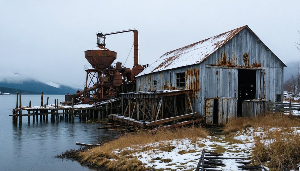
Treadwell Ruins: Gold Mining Legacy Near Juneau
For four decades, the Treadwell mining complex dominated Douglas Island across from Juneau, establishing itself as one of the world’s largest gold mining operations.
Beginning in 1882 when John Treadwell purchased the Paris lode claim, this industrial powerhouse extracted $66 million in gold over 35 years. The complex’s four mines employed nearly a thousand workers at peak production, processing roughly 10 million tons of ore using advanced mining technology of the era.
From 1882 to 1917, this massive operation extracted $66 million in gold while employing nearly a thousand workers at its peak.
Treadwell history ended dramatically on April 21, 1917, when catastrophic cave-ins flooded three mines with seawater during high tide.
Today, you’ll find concrete foundations, tramway remnants, and the famous “Glory Hole” scattered through Douglas Island’s forests, accessible via interpretive trails that preserve this remarkable industrial legacy.
Dyea: Gateway to the Klondike Gold Rush
Long before gold fever gripped the world, Dyea existed as a seasonal fishing camp where Chilkat Tlingit from Klukwan controlled the essential Chilkoot Pass trade route to interior First Nations.
They’d burned Fort Selkirk in 1852, preventing Hudson’s Bay from establishing direct interior trade.
You’ll find Dyea history dramatically changed when fall 1897 newspaper headlines announced Klondike strike wealth.
Boatloads of freedom-seeking prospectors flooded Dyea, creating a boomtown of 3,500 residents spanning five blocks wide and eight blocks long.
Gold Rush impacts included thriving Tlingit packing businesses, where natives charged fees transporting gear over Chilkoot Pass.
However, the deadly April 3, 1898 Palm Sunday Avalanche and White Pass railroad completion sealed Dyea’s fate, leaving only ruins within today’s national park.
Portlock (Port Chatham): Alaska’s Most Mysterious Abandoned Settlement
While Dyea’s abandonment followed predictable economic forces, Portlock presents Alaska’s most enigmatic ghost town story.
You’ll find this remote Kenai Peninsula settlement’s Indigenous history traces back centuries to the Alutiiq/Sugpiaq people who seasonally occupied Port Chatham.
European contact began in the late 1700s, leading to Russian sealing operations and eventual American commercial fishing.
Exploring Alaska’s Abandoned Places: What Visitors Should Know
Before you venture into Alaska’s abandoned settlements, understanding access requirements and safety considerations will determine your experience at these remote historical sites.
Each location presents unique challenges that’ll test your preparation and wilderness skills.
Kennicott requires traversing sixty miles of gravel road plus footbridge access, while Treadwell offers easier day-trips from Juneau.
The Chilkoot Trail demands permits and backcountry expertise for overnight exploration.
You’ll encounter unstable abandoned infrastructure at most sites—from Kennicott’s fourteen-story mill to Treadwell’s deteriorating foundations.
Weather constraints affect seasonal accessibility, particularly during Alaska’s harsh winters.
Follow designated trails and park guidance to safely experience these sites’ historical significance.
Whether you’re photographing iconic structures or hiking interpretive routes, proper planning guarantees you’ll explore Alaska’s ghost towns responsibly while preserving their archaeological integrity.
Frequently Asked Questions
Are There Any Other Notable Ghost Towns in Alaska Besides These Six?
You’ll find additional ghost towns with historical significance including Kennicott’s copper-mining ruins, Dyea’s Klondike-era remains, Treadwell’s flooded gold operations, Unga’s Russian settlements, and Portage’s earthquake-devastated structures throughout Alaska’s remote regions.
The abandoned mines of Kennecott Alaska stand as a testament to the region’s rich mining history and the boom-and-bust cycles that defined it. Visitors can explore the remnants of the majestic structures that once housed miners and their families, now overtaken by nature. This haunting yet captivating landscape draws adventurers and history buffs alike, eager to uncover the stories buried within the mountains.
What Safety Precautions Should Visitors Take When Exploring These Abandoned Sites?
Don’t venture unprepared into Alaska’s frozen time capsules. You’ll need essential safety gear including sturdy boots, respirators, and first aid supplies. Maintain constant wildlife awareness—bears and other dangerous animals frequently inhabit these remote, crumbling settlements.
Can You Legally Remove Artifacts or Souvenirs From These Ghost Towns?
No, you can’t legally remove artifacts from Alaska’s ghost towns. Federal ARPA laws and state statutes impose serious legal consequences including felony charges. Artifact preservation requires you leave everything untouched and report findings to authorities.
Which Ghost Towns Are Accessible Year-Round Versus Only During Summer Months?
You’ll find year round access at Kennicott and McCarthy with their dozen winter residents, while summer restrictions limit Portage, Dyea, Treadwell, and Sulzer due to harsh weather conditions blocking roads.
Do Any of These Locations Offer Overnight Camping or Accommodation Options?
You’ll find accommodation options at Kennicott’s historic lodge, Skagway’s seasonal hotels, and Hyder’s cabins. Backcountry camping requires camping permits for Chilkoot Trail, while dispersed camping’s allowed on Forest Service lands.
References
- https://www.atlasobscura.com/things-to-do/alaska/ghost-towns
- https://getlostinamerica.com/alaska-ghost-towns/
- https://www.youtube.com/watch?v=TC_KPrhDByY
- https://thealaskafrontier.com/ghost-towns-in-alaska/
- https://www.thealaskalife.com/blogs/news/alaska-ghost-towns-youve-probably-never-heard-of
- https://www.gi.alaska.edu/alaska-science-forum/ghost-towns-scattered-across-alaska-map
- https://alaskaitinerary.com/haunted-places-in-alaska/
- https://www.miningnewsnorth.com/story/2022/01/07/northern-mining-history/alaskan-copper-mine-once-giant-of-america/7136.html
- https://exploremccarthyalaska.com/kennecott-alaska-historic-mill-town/
- https://www.alaska.org/detail/kennicott-mine-ghost-town-walking-tour