You’ll find Kansas’s most famous ghost towns like Rome in Ellis County, which vanished within months after Fort Hays relocated in 1867, and Brooklyn in Douglas County, destroyed by Quantrill’s raiders in 1863. Rooks County’s railroad speculation created boom-and-bust cycles, while Rush County’s agricultural shifts abandoned entire farming communities by the 1920s. These prairie settlements succumbed to railroad bypasses, grasshopper plagues, and economic downturns that reshaped Kansas’s landscape through dramatic population declines and community relocations.
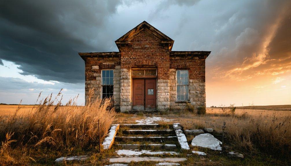
Exploring abandoned towns in Kansas unveils the stories of resilience and hardship that defined these communities. Each site tells a tale of dreams once realized, now fading into the landscape, with remnants of homes and businesses still standing as silent witnesses. Adventurers can trek through the ruins, uncovering artifacts and histories that paint a vivid picture of life in a bygone era.
Key Takeaways
- Rome in Ellis County vanished within months after Fort Hays relocated due to flooding in the late 1860s.
- Brooklyn in Douglas County was destroyed by Quantrill’s raiders during their 1863 retreat from Lawrence.
- Cresson in Rooks County relocated twice due to railroad speculation, eventually becoming Palco in 1888.
- Pioneer, Nekoma, and Pleasant Dale in Rush County declined after railroad bypasses eliminated transportation access.
- Stull in Douglas County gained fame through folklore and ghostly reputation rather than historical abandonment.
Ellis County’s Abandoned Settlements
While Ellis County established itself on February 26, 1867, its earliest settlements couldn’t withstand the harsh realities of frontier life.
You’ll find Rome, platted by the Lull brothers in May 1867, vanished within months after Fort Hays relocated following devastating June floods. The settlement dynamics shifted rapidly as military protection moved, leaving communities vulnerable.
Chetolah represents unique cultural influences, occupied sequentially by Pawnee Indians and diverse settler groups across three distinct phases.
You can trace similar patterns in Yocemento, an unincorporated Big Creek Township community that couldn’t sustain development. Bantam lasted slightly longer from 1906-1910 before its post office transferred to Hyacinth.
Big Creek Station, established in 1867 along historic trails, succumbed to changing transportation patterns and declining Indian raids after 1869. The arrival of the Kansas Pacific Railroad attracted settlers to more strategically positioned locations, leaving many early settlements abandoned. The grasshopper scourge of 1874 forced even more established communities to empty as residents fled the devastating insect plague that destroyed crops throughout the region.
Douglas County’s Lost Communities
Although Douglas County avoided the complete abandonment patterns seen elsewhere, its lost communities reveal Kansas’s most turbulent chapters during Bleeding Kansas and beyond.
Douglas County’s vanished towns stand as silent witnesses to Kansas’s bloodiest era of territorial warfare and political upheaval.
You’ll discover Hickory Point history through the settlement that sparked territorial violence when Charles Dow’s murder by Franklin Coleman triggered the Wakarusa War and Pottawatomie Massacre. The town renamed itself Stony Point to escape notoriety.
Franklin’s legacy remains as a proslavery stronghold that fueled territorial conflicts before vanishing entirely.
Brooklyn survived until Quantrill’s raiders destroyed it during their 1863 retreat from Lawrence.
Bloomington thrived as an abolitionist community with underground railroad connections until Clinton Lake’s construction displaced residents. The New England Emigrant Aid Company facilitated systematic settlement of Free State communities like these before their eventual abandonment.
Even Stull gained ghostly reputation through supernatural legends rather than historical abandonment, demonstrating how folklore shapes perception.
Globe once served as a trading post and stage stop along the Santa Fe Trail before eventually disappearing from the landscape.
Rooks County’s Forgotten Towns
You’ll find Rooks County’s abandoned settlements tell the story of railroad speculation and shifting transportation routes that shaped Kansas’s settlement patterns in the late 1800s.
Cresson exemplifies this phenomenon when residents relocated their entire community based on rumors that the Union Pacific would bypass their original site, abandoning the old town for “New Cresson” along the anticipated rail line. The original settlement was founded by Pennsylvania settlers in 1877, complete with essential buildings and a post office established in February 1879.
These forgotten communities, including Adamson, Alcona, Amboy, and Chandler, represent the county’s peak population of 9,966 in 1920 before decades of decline reduced it to an estimated 4,778 residents by 2023. Many of these settlements experienced rapid decline during economic downturns that left former boom towns virtually uninhabitable.
Abandoned Railroad Communities
Rooks County’s railroad boom of the 1880s triggered a series of dramatic town relocations as communities desperately chased the promise of rail connections.
You’ll find that railroad relocations became a defining characteristic of this era, as entire towns literally moved buildings, businesses, and families to secure their economic survival.
The Cresson relocation saga exemplifies this community resilience. When rumors spread about a Union Pacific bypass in 1885, residents relocated to “New Cresson,” only to move again in 1888 when tracks passed the original site.
The new settlement became Palco, named after railroad officials Palmer and Cole. The town established its first post office and school in 1879, serving a population that reached 279 by 1910. Similarly, Motor’s residents relocated three-fourths of a mile west to create Codell when the railroad refused their depot location.
You can’t overstate how railroads shaped these communities’ destinies.
Historic Settlement Patterns
When the Kansas Legislature defined Rooks County’s boundaries in 1867, they established 23 townships that would witness one of the state’s most complex settlement patterns.
You’ll find that early community evolution followed distinct waves: cattle dealers first established Stockton in 1872, creating the county seat that grew to 700 residents by 1883.
Religious groups shaped eastern settlements as Quakers founded Mt. Ayr and Laton between 1877-1880, while the Nicodemus Negro settlement emerged nearby in 1877.
Railroad rumors triggered dramatic relocations—Cresson residents abandoned their town for “New Cresson” fearing Union Pacific would bypass them. The region’s abundant magnesian limestone provided crucial building materials for constructing permanent structures in these emerging communities.
This constant movement created today’s ghost town landscape: fifteen forgotten communities including Adamson, Motor, and Sugarloaf, reflecting Kansas settlers’ relentless pursuit of opportunity and prosperity.
Rush County’s Historic Remnants
You’ll find Rush County’s ghost towns tell the story of Kansas’s railroad boom and agricultural settlement patterns from the 1870s through 1890s.
The county’s abandoned communities like Pioneer, Nekoma, and Pleasant Dale represent three distinct phases of decline: railroad bypasses that left once-promising settlements without transportation access, agricultural shifts that made farming communities unsustainable, and the gradual abandonment of ethnic enclaves like the Volga German settlements. Among these settlements was Schoental, which began declining in 1886 as farmers moved from the village to individual homesteads.
Today, you can still locate remnants of these communities through surviving structures like Olney’s St. Mary’s Help of Christians Church and Nekoma’s lone grain elevator, which serve as physical markers of Rush County’s lost agricultural heritage. The county was officially established in 1874, marking the formal organization of these early settlement areas.
Abandoned Railroad Settlement Towns
Across Rush County’s windswept plains, railroad companies carved out numerous settlements during the late 1800s, leaving behind a scattered collection of ghost towns that tell the story of western Kansas development.
You’ll find Timken history rooted in Henry Timken’s speculative land purchases after the Atchison, Topeka & Santa Fe Railroad built their depot in 1887. The community peaked at 170 residents by 1940 before passenger services ended in the 1960s.
McCracken legacy traces back to Missouri Pacific Railroad’s westward expansion during the gold rush era. You can trace its brief prosperity through the post office opening in 1887, complete with banks, stores, and the McCracken Enterprise newspaper.
When railroads abandoned these stops in the 1970s, these once-thriving settlements became silent monuments to America’s railroad expansion dreams.
Agricultural Community Decline
Beyond the railroad’s influence, Rush County’s agricultural communities faced their own cycle of boom and decline that reshaped the western Kansas landscape.
You’ll find McCracken’s population plummeted to just 250 residents by 1910, while La Crosse experienced temporary growth reaching 505 by 1920 during the gas boom before inevitable decline.
The declining agriculture patterns devastated local economies as farmland values crashed from $601 per acre in 1982 to $413 by 1987.
Rural exodus accelerated when wheat yields hit devastating lows of 11.1 bushels per acre in 1940, forcing farmers into debt spirals.
Today’s Rush County spans 718 square miles with only 2,800 residents, creating a density below four people per square mile—testament to agricultural community abandonment.
Preserved Historical Structures
While economic forces decimated Rush County’s population, determined preservation efforts have saved remarkable architectural remnants that document the area’s diverse settlement patterns.
You’ll discover Liebenthal Structures showcase Volga German craftsmanship, where settlers quarried limestone to recreate Russian village aesthetics after establishing their community February 21, 1876. The church, rebuilt and dedicated November 8, 1921 following devastating 1917 fire damage, anchors this historic settlement.
St. Joseph Church complex demonstrates Catholic German-Russian architectural traditions, featuring Joseph Herrman’s 1886 house and distinctive grotto stonework.
You can explore the Post Rock Museum‘s native stone displays and Timken’s relocated depot with its characteristic six-over-six windows. These preserved structures represent freedoms sought by immigrant communities who transformed Kansas prairie into thriving settlements before economic decline scattered their descendants.
Semi-Ghost Towns Still Clinging to Life
Some Kansas communities have found ways to halt their slide into oblivion, earning the designation of semi-ghost towns as they maintain skeleton populations and basic services.
Against all odds, these resilient Kansas towns cling to life with skeleton crews and unwavering determination to survive.
You’ll find Cedar Point in Chase County exemplifies community resilience, operating its post office since 1862 while preserving its historic flour mill as a landmark.
Hunter’s 51 residents demonstrate determination, sustaining their post office since 1895 despite minimal infrastructure.
Huron’s accessible Highway 73 location helped 74 people survive after postal operations ended in 1992.
Neosho Falls maintains 137 residents through continuous postal service since 1857.
These communities showcase how tourism impact and strategic positioning can preserve remnants of frontier heritage, allowing you to witness authentic Kansas history through their persistent survival against demographic decline.
Sumner County’s Railroad Relics

Across Sumner County’s windswept plains, abandoned railroad corridors tell the story of Kansas’s transportation boom that transformed scattered settlements into thriving agricultural hubs before leaving them stranded by changing economic tides.
You’ll find Perth’s remnants along the Atchison, Topeka and Santa Fe line, where railroad expansion peaked in 1910 with 240 residents. The town boasted banks, mills, and grain elevators before decline set in.
Nearby Corbin operated from 1881 to 1974, while Hunnewell emerged after H.H. Hunnewell’s railroad reached there in 1880. Rome and South Haven connected via the Leavenworth, Lawrence & Galveston branch, but their stockyards emptied by 1891.
These railroad relics represent ghost town preservation challenges, where crumbling foundations mark once-bustling shipping points for livestock and grain.
Sedgwick County’s Vanished Villages
When Sedgwick County organized in the 1870s, competing settlements emerged across its prairie landscape, each hoping to capture the county seat and secure their economic future.
You’ll find Old Park City‘s story particularly compelling—founded in the 1870s, it lost vital county-seat battles and watched Wichita’s growth eclipse its prospects. The original settlement, located five miles west of present-day Valley Center, eventually vanished entirely.
Clonmel represents another vanished settlement, operating from 1871 until 1938 in Illinois Township. You can trace its decline through agricultural consolidation and transportation shifts.
Agricultural consolidation and changing transportation patterns gradually erased Clonmel from the Kansas prairie between 1871 and 1938.
Railroad stations like Birch (1879-1894) and Blendon (1875-1884) disappeared when rail routing changed.
Throughout northern and southern Sedgwick County, these vanished settlements typically leave behind cemeteries, foundation ruins, and occasional farmhouses—silent witnesses to prairie dreams unfulfilled.
Post Office Closures and Community Decline

Throughout Kansas’s history, post office closures have served as reliable indicators of community decline and eventual abandonment. When federal postal services withdrew, you’d witness the systematic erosion of community resilience as residents lost their primary connection to the outside world.
Post office impacts created cascading effects throughout these settlements. Empire City’s closure in 1913 followed mining’s decline, while Treece’s 2004 closure preceded complete evacuation by 2012.
Irving’s post office shut July 31, 1960, coinciding with the town’s ghosting after dam construction news.
- Economic triggers: Mining decline in Treece and Empire City directly caused postal service withdrawal
- Rapid abandonment: Cofachique vanished overnight when its post office relocated in 1859
- Structural remnants: Kanona’s ruins remain on private property after 1955 closure
You’ll find these closures marked the final chapter for most Kansas ghost towns.
Preserving Kansas Ghost Town Heritage
While many Kansas ghost towns have succumbed to complete abandonment, dedicated preservation efforts now protect their historical significance for future generations.
You’ll find passionate volunteers restoring Quindaro Townsite buildings, linking Underground Railroad history to Kansas-Nebraska Act routes. Heritage preservation receives substantial support through grants like the National Trust’s $50,000 funding for Nicodemus in 2018, despite the National Park Service’s $12 billion maintenance backlog.
Community engagement drives success stories across Kansas. Nicodemus earned National Historic Site designation in 1996, while descendants actively share homesteader narratives through museums and documentaries.
Community engagement transforms forgotten places into living history, where descendants preserve homesteader stories through passionate storytelling and cultural institutions.
You can witness strategic adaptive reuse, from Sumner County’s mill-to-restaurant conversion to Elk Falls’ seasonal businesses operating alongside preserved 1893 structures. These collaborative efforts guarantee physical remnants survive, keeping community memory alive.
Frequently Asked Questions
What Legal Issues Exist When Visiting or Exploring Abandoned Ghost Towns?
You’ll face trespassing laws when conducting urban exploration of ghost towns, even if they appear abandoned. Private ownership often remains despite appearances, making unauthorized entry illegal without verified abandonment status or proper legal possession.
Are There Any Documented Paranormal Activities in Kansas Ghost Towns?
Like scattered puzzle pieces across prairie landscapes, you’ll find ghost encounters documented at Stull Cemetery’s portal legends and Lorenz Schlicter’s child spirits. Spectral sightings include battle sounds at Pawnee Rock dating from 1800s trail conflicts.
Which Ghost Towns Offer the Best Photography Opportunities for Visitors?
You’ll find exceptional ghost town landscapes at Quindara Ruins’ dramatic bluffs and Bloomington Beach’s submerged remnants. Lecompton’s preserved Civil War architecture and Atchison’s Victorian haunted houses offer outstanding abandoned architecture photography opportunities year-round.
What Safety Precautions Should Be Taken When Exploring These Abandoned Sites?
You’ll need proper safety gear including sturdy boots, first aid supplies, and flashlights. Maintain wildlife awareness for snakes, spiders, and bats. Travel in groups, scout beforehand for structural hazards, and always inform others of your exploration plans.
How Do Property Ownership Laws Affect Access to Ghost Town Locations?
You’ll face trespassing charges if you enter abandoned ghost towns without permission, since property rights remain intact regardless of vacancy. Land use restrictions and ownership laws don’t disappear when towns become deserted.
References
- https://en.wikipedia.org/wiki/List_of_ghost_towns_in_Kansas
- https://legendsofkansas.com/kansas-ghost-town-list/
- https://www.travelks.com/blog/stories/post/13-most-haunted-places-in-kansas-you-must-visit-this-fall/
- https://www.youtube.com/watch?v=dF7vGl5xasI
- https://www.youtube.com/watch?v=VPZtNoncnig
- https://globaldebauchery.com/weird-towns-in-kansas/
- https://fhsuguides.fhsu.edu/kansasheritage/elliscounty
- https://www.ellisco.net/144/Ellis-County-History
- http://www.kancoll.org/books/cutler/ellis/ellis-co-p2.html
- https://digging-history.com/2015/04/01/ghost-town-wednesday-rome-kansas/


