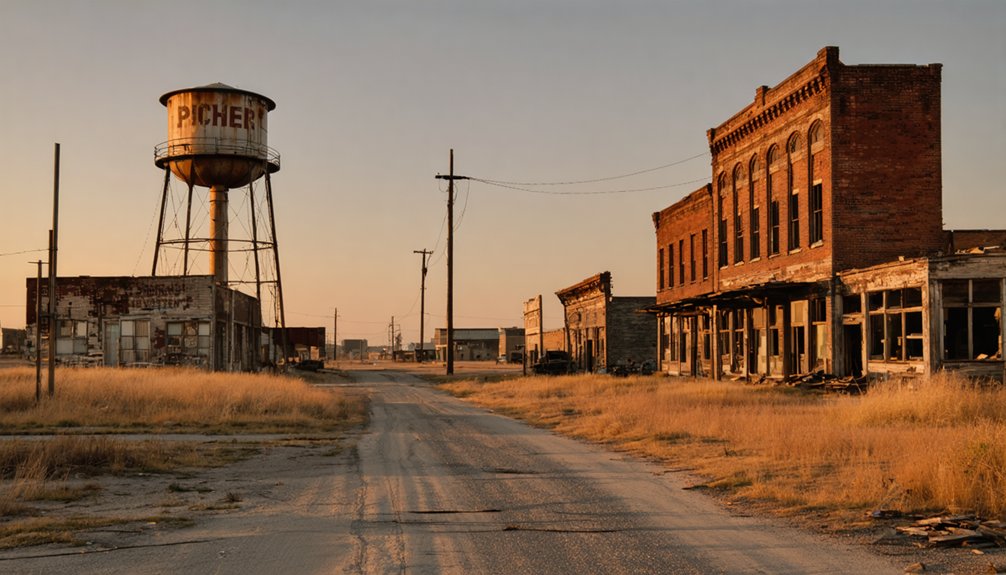
You’ll find Oklahoma’s most famous ghost towns scattered across landscapes where mining booms, railroad abandonment, and environmental disasters left behind haunting remnants of once-thriving communities. Picher, which peaked at 14,252 residents in 1926, became a toxic wasteland from lead-zinc mining before its 2009 dissolution. Ingalls gained notoriety from the 1893 Doolin-Dalton Gang shootout, while towns like Slick and Texola declined from 5,000 and 581 residents respectively to near-abandonment. These preserved settlements offer compelling insights into Oklahoma’s turbulent settlement patterns and economic transformations.
Key Takeaways
- Picher was Oklahoma’s largest ghost town, peaking at 14,252 residents in 1926 before environmental contamination led to dissolution in 2009.
- Ingalls gained fame for the 1893 Doolin-Dalton Gang shootout, now commemorated with annual reenactments and historical tourism attractions.
- Slick reached 5,000 residents during the 1920 oil boom but declined to under 500 after rail abandonment and resource depletion.
- Texola experienced dramatic population loss from 581 in 1930 to just 40 today due to Great Depression and Dust Bowl impacts.
- Boggy Depot preserves remnants of essential frontier services including schoolhouse, church, and Masonic Lodge foundations among overgrown ruins.
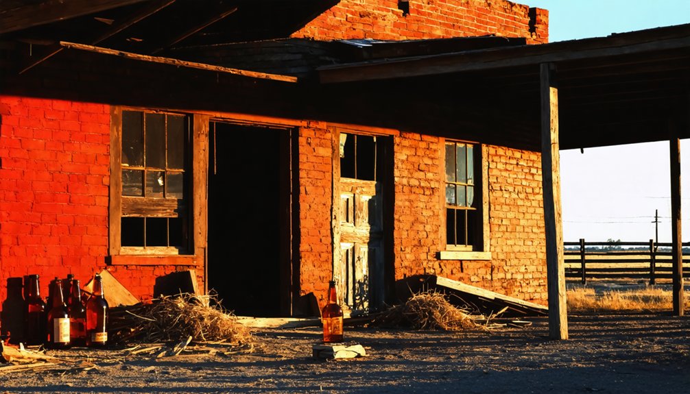
Picher: The Toxic Mining Disaster That Erased a Town
Though Picher once thrived as a bustling mining town in northeastern Oklahoma, it’s now a stark reminder of environmental catastrophe‘s devastating power.
Picher’s history began in the 1900s when it became part of the Tri-State Lead-Zinc Mining District, producing massive quantities of valuable ore through 248 mills. The town was named after O.S. Picher, owner of the Picher Lead Company who played a key role in its early development. However, the environmental impact proved catastrophic.
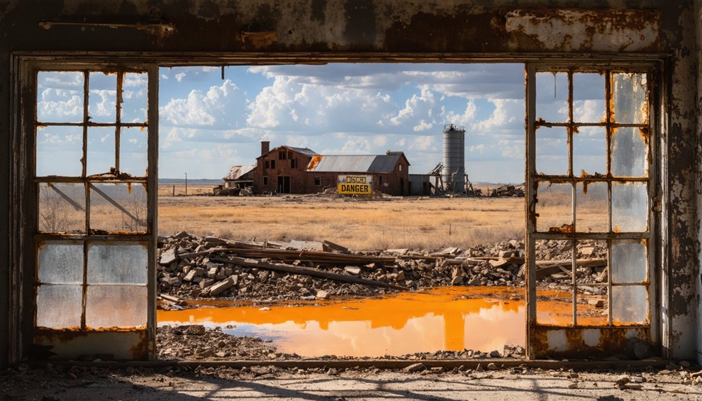
When mining ceased in 1967, over 14,000 abandoned mineshafts and 178 million tons of toxic chat piles remained scattered across the landscape. The region’s mining legacy led to the creation of two Superfund sites spanning both Oklahoma and Kansas. Acidic mine water contaminated with heavy metals poisoned Tar Creek, while 34% of children suffered lead poisoning by 1994.
After an EF4 tornado struck in 2008, the few remaining holdouts finally accepted federal buyouts, and Picher officially dissolved in 2009.
Acme: Rise and Fall of a Gypsum Mining Company Town
While Picher’s story demonstrates how extractive industries can poison entire communities, Oklahoma’s ghost towns also include places where mining operations simply ran their course and departed.
You’ll find Acme in southeastern Grady County, where the Acme Cement and Plaster Company established a complete company town in 1911. They built a large mill and power plant to process local gypsum rock into plaster for house construction, creating a bustling community that operated its own post office from 1913 to 1931.
The gypsum industry supported families through mining, farming, and ranching, with rail access enabling efficient shipments. During excavations, workers uncovered prehistoric mastodon remains in the open-pit gypsum mines, revealing the area’s ancient history. The town featured company houses that provided housing for workers and their families. However, community resilience couldn’t overcome economic vulnerability when operations ceased, leaving only mill and power plant ruins in this now-abandoned ghost town.
Ingalls: Where the Dalton Gang Met Their Match
You’ll find Ingalls in northeastern Payne County, where one of the Old West’s most dramatic gunfights unfolded on September 1, 1893.
The Doolin-Dalton Gang had turned this small community into their sanctuary until a posse of federal marshals arrived to end their reign of terror in a blazing shootout that left multiple casualties on both sides. The gang members were playing poker at the Ransom Saloon when the marshals launched their surprise attack. The gunfight proved even more intense and deadly than the famous Gunfight at the O.K. Corral.
Today, this infamous battle site stands as a haunting reminder of Oklahoma Territory’s lawless frontier days.
The Infamous 1893 Shootout
When the sun rose over Ingalls on September 1, 1893, neither the Doolin-Dalton Gang nor the fourteen U.S. Deputy Marshals knew they’d create one of the deadliest confrontations in Western history.
You’ll find this 1893 shootout exceeded even the O.K. Corral’s fury. The battle erupted when lawmen targeted the gang during their morning drinking session.
The gunfight’s devastating toll included:
- Three deputy marshals killed: Thomas Hueston, Lafayette Shadley, and Richard Speed
- Two innocent bystanders murdered in the crossfire
- Multiple wounded outlaws who escaped except “Arkansas Tom” Jones
- Total casualties reaching nine men dead or wounded
The Ingalls aftermath marked Oklahoma Territory‘s climactic moment in establishing law over lawlessness, though surviving gang members continued their criminal activities. The gang was eventually eliminated by the persistent efforts of three elite lawmen known as the Three Guardsmen: Deputy Marshals Heck Thomas, Bill Tilghman, and Chris Madsen. The notorious outlaws had previously sought refuge in this remote location, where residents tolerated their presence out of fear or admiration.
Outlaw Gang’s Final Stand
The devastating 1893 shootout represented more than just another violent confrontation—it marked the beginning of the end for the Doolin-Dalton Gang‘s reign of terror across Oklahoma Territory.
You’ll discover that while the outlaws escaped Ingalls that September day, they’d lost their secure sanctuary forever. The Ingalls Gunfight shattered their operational base, forcing them into constant movement across Kansas, Missouri, and Arkansas.
Without their trusted hideout at Ransom Saloon, the gang couldn’t maintain the local support network that had sustained their criminal enterprise. Bill Doolin and his surviving members found themselves increasingly isolated, hunted relentlessly by federal marshals.
Their days of free-spending comfort in northeastern Payne County were finished, replaced by desperate flight that would ultimately seal their fate. The confrontation’s deadly toll included three deputies who lost their lives in the exchange, sending a clear message that law enforcement would pay any price to bring these outlaws to justice.
The relentless pursuit was orchestrated by U.S. Marshal Evett Nix, who had appointed one hundred marshals specifically to hunt down the Doolin-Dalton Gang.
Ghost Town Legacy Today
Although more than a century has passed since the infamous gunfight, Ingalls stands today as one of Oklahoma’s most historically significant ghost towns. Its empty streets and crumbling foundations serve as silent witnesses to the deadliest confrontation in U.S. Marshals history.
You’ll find this northeastern Payne County site carefully maintained through ghost town preservation efforts by local historical societies. The remaining structures, including Ransom Saloon remnants, tell stories of September 1, 1893’s violent showdown.
Today’s historical tourism draws visitors seeking authentic Wild West experiences:
- Memorial plaques honor the nine casualties, including three fallen marshals
- Annual reenactments commemorate the battle anniversary
- Ghost town trails connect Ingalls to Oklahoma’s outlaw heritage
- Educational markers detail the Doolin-Dalton gang’s final chapter
Beer City: Outlaws and Liquor in No Man’s Land
You’d find saloons like the Yellowsnake Hotel operated by madam Pussy Cat Nell, who catered to cowboys during cattle-shipping seasons.
Wild frontier establishments like Pussy Cat Nell’s Yellowsnake Hotel thrived by serving thirsty cowboys during busy cattle-shipping seasons.
Self-appointed Marshal Lewis “Brushy” Bush enforced his own brand of order until Nell shot him in July 1888 over a tax dispute.
Vigilante justice ruled through hanging claim jumpers and burning saloons.
The 1890 Enabling Act finally attached this territory to Oklahoma, ending Beer City’s reign of unchecked vice.
Boggy Depot: From Choctaw Trading Hub to Empty Fields
By the Civil War’s eve, you’d have encountered:
- Complete business district with apothecary, blacksmith, bakery, and hotel
- Strategic location facilitating commerce in eastern Chickasaw district
- Schoolhouse and church with upper-floor Masonic Lodge
- Stage line connections linking territorial settlements
Today, you’ll discover only tree-choked foundations and abandoned wells marking this Oklahoma State Park ghost town.
Texola: Fire, Depression, and Highway Bypass Spelled Doom

You’ll find that Texola’s transformation from a thriving Route 66 town of 581 residents in 1930 to today’s near-ghost town of just 40 people resulted from a devastating combination of disasters.
The Great Depression and Dust Bowl of the 1930s triggered the initial population exodus, while destructive fires eliminated key commercial structures during the town’s most vulnerable period.
When interstate highways later bypassed Route 66 entirely, they severed Texola’s economic lifeline and accelerated its final abandonment.
Triple Disaster Strikes Town
While Texola thrived through the 1920s with its bustling business district and peak population of 581 in 1930, the town couldn’t withstand the devastating combination of economic collapse, environmental disaster, and infrastructure changes that struck in rapid succession.
The Great Depression demolished Texola’s agricultural economy, forcing closure of cotton gins and the gristmill that anchored local commerce. Simultaneously, the Dust Bowl devastated farmland, driving residents westward as “Okies” seeking survival in California.
Without effective disaster recovery strategies or community resilience initiatives, Texola’s population plummeted from 581 to just 45 by 1990.
Key factors in Texola’s decline include:
- Economic collapse eliminated agricultural foundation
- Environmental catastrophe destroyed farming viability
- Mass migration depleted workforce and customer base
- Infrastructure abandonment accelerated business closures
Route 66 Bypass Impact
Just as Texola began recovering from the Depression and Dust Bowl devastation, Route 66‘s arrival in 1926 offered new hope for economic revival.
You’ll find that the highway brought growing traveler traffic through town along 5th Street, supporting local businesses for decades. The road was rededicated as Will Rogers Highway in 1952, cementing its importance.
However, bypass consequences proved devastating when I-40 diverted main traffic in the early 1970s. The final blow came in 1975 when the last Route 66 section from Sayre to Erick was bypassed.
You’d now need to veer off the interstate to reach Texola, drastically reducing visitor access. Despite lingering Route 66 nostalgia and historic attractions like Magnolia Service Station, the town’s population dwindled from 581 residents to just 40 today.
Exploring Oklahoma’s Ghost Town Trail Routes
How can adventurers best navigate Oklahoma’s scattered ghost towns across the state’s diverse terrain?
One intriguing opportunity for exploration is to explore the abandoned town of Picher, where remnants of its mining history tell a story of both prosperity and decline. Adventurers will encounter landscape features shaped by years of human activity, as well as the haunting echoes of its past inhabitants. With each visit, the ghostly remnants invite reflection on the impact of industry and the passage of time, making it a compelling destination for those seeking a deeper understanding of Oklahoma’s history.
You’ll discover multiple specialized trail systems designed for accessing these historical landmarks. The Green Country Oklahoma Adventure Tour offers 500 miles through eastern landscapes, featuring ghost town Yonkers as discovery point DP12.
Meanwhile, the Oklahoma Adventure Trail circles the entire state with 70% dirt roads connecting various historical sites.
For thorough exploration, consider these ghost town routes:
- GPS waypoints from “Ghost Towns of Oklahoma” load directly into navigation devices for precise location finding
- Interactive Google Maps and Google Earth views enable advance trip planning across multiple counties
- Historical J.W. Morris map collections detail 1858-1935 settlement locations with numbered reference systems
- Specialized routes like Coyote Trail to Silver City span 85 miles with elevation gains exceeding 3,600 feet
You’ll find technical ratings averaging 1-2 across varied terrain.
Mining Booms That Created and Destroyed Communities
You’ll find that Oklahoma’s mining booms created some of the state’s most dramatic rise-and-fall stories, where entire communities flourished and then vanished within decades.
These extractive industries left behind two distinct types of ghost towns: those abandoned due to toxic contamination that made them uninhabitable, and others that simply died when their natural resources ran dry.
Understanding these patterns reveals how approximately 2,000 Oklahoma communities fell victim to the boom-and-bust cycles that defined the state’s early industrial development.
Toxic Legacy Towns
While most Oklahoma ghost towns faded due to economic shifts or resource depletion, some communities met a more sinister fate through environmental devastation that rendered them uninhabitable.
Picher exemplifies how toxic contamination can destroy thriving communities. Founded in 1913 after discovering lead and zinc on Harry Crawfish’s claim, this Ottawa County town peaked at 14,252 residents in 1926. The Tri-State district produced essential ammunition metals for both World Wars, but decades of mining left devastating consequences.
You’ll find Picher’s environmental health crisis stemmed from multiple hazards:
- Chat piles reaching 200 feet tall scattered toxic dust containing lead and iron remnants
- Underground mine shafts collapsed, creating dangerous sinkholes throughout the business district
- Groundwater contamination from 248 mills poisoned local water supplies
- EPA designated the area a Superfund site in 1983
Government officials relocated remaining residents in 2006, officially dissolving Picher in 2009.
Resource Depletion Abandonment
Beyond environmental contamination, Oklahoma’s ghost towns more commonly emerged from the classic boom-and-bust cycle that defined the state’s extractive industries.
You’ll find communities like Picher, where lead-zinc mining created nearly 10,000 residents by the 1910s before resource depletion left 14,000 abandoned shafts.
McCurtain’s coal operations thrived until a devastating 1912 mine explosion killed 73 miners, bankrupting the company.
America Town’s timber boom supported 200 residents until forests disappeared, forcing a desperate shift to cotton ginning.
These communities lacked sustainable resource management strategies, and their community resilience crumbled when single industries failed.
Without economic diversification, entire populations abandoned their homes once the extractable wealth vanished.
Railroad Towns Left Behind by Changing Transportation
As Oklahoma’s railroad network expanded in the late 1800s, entire communities rose and fell based on where companies chose to lay their tracks.
You’ll find that railroad impact determined which settlements thrived while others became ghost town origins. When the Missouri, Kansas and Texas Railroad bypassed established centers like Boggy Depot and Perryville in 1872, these once-prosperous towns began their inevitable decline.
The pattern repeated across the state as transportation shifted from rivers to rails:
- Eschiti lost prominence when tracks were laid two miles away, allowing Kell City and Grandfield to overtake it.
- Henryetta’s original site faced financial collapse after being bypassed, leading to disincorporation.
- Parkersburg lost 700 residents when railroads intersected three miles east in Clinton.
- Slick peaked at 5,000 residents in 1920 before rail abandonment reduced it to under 500.
Preserving the Stories of Oklahoma’s Vanished Settlements
Community Involvement drives much of this preservation work.
Volunteers repair graffiti-damaged structures like Sacred Heart Bakery’s walls while contributing to Facebook groups that identify new ghost town locations.
The Oklahoma Route 66 Museum’s “Ghost Towns: Phantoms of 66” exhibit showcased these preservation efforts, emphasizing how abandoned cemeteries and faded foundations reveal settlers’ stories, ensuring “our future began with our past.”
Frequently Asked Questions
Are There Any Ghost Towns in Oklahoma That Are Completely Safe to Visit?
Yes, you’ll find completely safe ghost town visits at Kenton, Texola, Gotebo, Nowata, Lenapah, Reed, and Maud. These locations require basic exploring precautions but lack toxic hazards, ensuring ghost town safety for curious travelers.
What’s the Best Time of Year to Explore Oklahoma’s Abandoned Towns?
Want perfect exploration conditions? You’ll find the best weather during fall months (September-November) with comfortable 40-65°F temperatures, dry roads, and seasonal events like Poteau Balloon Fest enhancing your ghost town adventures.
Do You Need Special Permission to Visit These Ghost Town Locations?
You don’t need visitation permits for most Oklahoma ghost towns, but you must respect private property boundaries. Ghost town regulations vary by location – always contact property owners before entering to avoid trespassing charges.
Are There Guided Tours Available for Oklahoma’s Most Famous Ghost Towns?
You’ll hit paydirt with several guided exploration options. Shamrock Oklahoma Ghost Towns Tour offers app-based guidance through multiple sites, while Red River tours provide documented historical significance through self-guided road trips covering abandoned settlements.
What Should Visitors Bring When Exploring These Remote Abandoned Settlements?
You’ll need hiking essentials like sturdy boots, water, navigation tools, and safety gear for unstable terrain. Bring camera equipment to document structures, plus protective clothing against toxic dust from abandoned mining operations.
References
- http://sites.rootsweb.com/~oktttp/ghost_towns/ghost_towns.htm
- https://www.youtube.com/watch?v=5d-wHDTIbb0
- https://pocketsights.com/tours/tour/Shamrock-Oklahoma-Ghost-Towns-Creek-Lincoln-Payne-and-Pawnee-Counties-2749
- https://www.okhistory.org/publications/enc/entry?entry=GH002
- https://abandonedok.com/class/disappearing-town/
- https://adamthompsonphoto.com/the-sad-tale-of-picher-oklahoma/
- https://www.tandfonline.com/doi/full/10.1080/17445647.2022.2057877
- https://todd-stewart.format.com/3796785-picher-oklahoma
- https://en.wikipedia.org/wiki/Picher
- https://www.youtube.com/watch?v=pPB4Bal_mm8


