You’ll find Vermont’s most famous ghost towns include Glastenbury, where mysterious disappearances in the 1940s created the legendary Bennington Triangle, and Plymouth’s gold rush site that once housed over 100 miners before economic collapse. Ricker Basin’s 4,000-acre settlement housed 50 families until harsh mountain conditions forced abandonment, while Greenbank’s Hollow thrived as a textile center until an 1885 fire destroyed everything. These haunting remnants offer compelling glimpses into the state’s forgotten communities and their enigmatic histories.
Key Takeaways
- Glastenbury peaked at 250 residents in 1880 before mysterious disappearances and economic collapse created Vermont’s most notorious ghost town.
- Plymouth Five Corners boomed during the 1855 gold rush with hotels and saloons before becoming commercially unviable by 1900.
- Ricker Basin housed 50 families across 4,000 acres until harsh mountain conditions forced abandonment, leaving stone walls and cellars.
- Greenbank’s Hollow operated the Northeast’s largest textile center until a devastating 1885 fire destroyed the five-story mill complex.
- Somerset’s 300 residents depended on logging until deforestation caused collapse; the dam construction later submerged remaining settlement remnants.
Glastenbury: The Mysterious Vanishing Town of Bennington Triangle
Although Glastenbury reached its peak population of nearly 250 residents in 1880, this Vermont settlement’s prosperity proved fleeting, ultimately earning it a place among the state’s most mysterious ghost towns.
You’ll discover that logging dominated its early economy, supported by infrastructure including a sawmill, blacksmith shop, and boarding house. However, economic collapse followed resource depletion, and an 1898 flood destroyed essential transportation links after failed tourism revival attempts. Nature has reclaimed the abandoned settlement, with forests growing over former homes and businesses to create an increasingly eerie atmosphere.
What sets Glastenbury apart are the Glastenbury legends surrounding its abandonment. The Abenaki avoided this mountain due to supernatural beliefs about man-eating stones. The town’s decline accelerated after two murders occurred in the 1890s, further darkening its reputation.
You’ll find documented supernatural sightings including the mysterious disappearances of five people between 1945-1950 within the so-called Bennington Triangle, creating an enduring reputation that extends far beyond typical ghost town folklore.
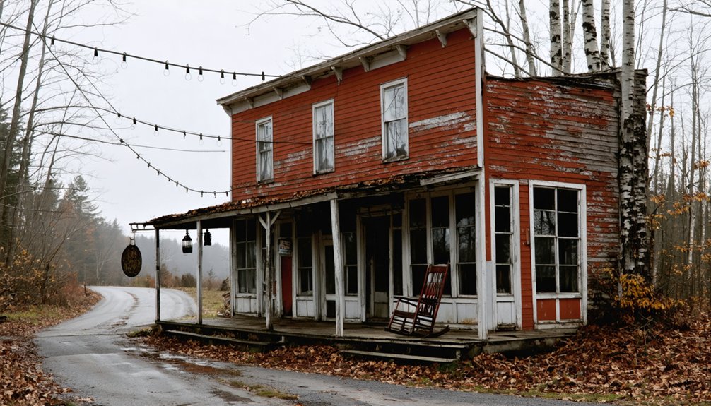
Plymouth Gold Rush Site: Vermont’s Forgotten Mining Boom
While Glastenbury’s mysteries center on unexplained disappearances, Plymouth’s ghost town status stems from a very different phenomenon—Vermont’s brief but intense gold rush that transformed quiet farming communities into bustling mining camps.
You’ll discover that William Hankerson’s 1855 gold discovery in Broad Brook sparked Vermont’s gold mining fever. Within months, over 100 miners abandoned farming to work claims across 40-50 sites, extracting remarkably pure 23.5-karat gold.
Plymouth Five Corners flourished with hotels, saloons, and dance halls serving prospectors who earned $7-25 daily.
The boom’s historical significance lies in its transformation of rural Vermont into mining territory. However, by 1900, the Vermont State Geologist confirmed gold wasn’t commercially viable. Mining operations utilized lode mining techniques to extract gold from hard rock formations rather than traditional stream panning methods.
Today, you’ll find only cellar holes, mine shafts, and rusted rails marking this forgotten chapter. Buffalo Brook remains a popular destination for recreational prospecting, where visitors can still try their luck panning for gold.
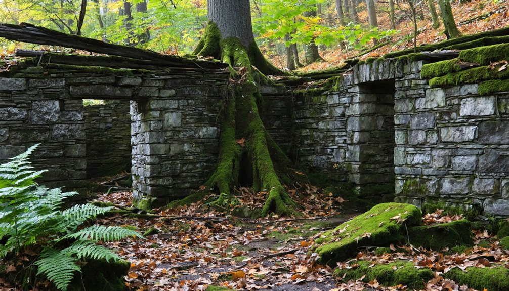
Ricker Basin: A Hidden Settlement in Little River State Park
You’ll find the remnants of Ricker Basin scattered across the southeastern slopes of Ricker Mountain, where nature has steadily reclaimed what was once a thriving 4,000-acre settlement housing 50 families.
The forest now conceals stone walls, cellar holes, and farm machinery from this early 1800s community that succumbed to harsh mountain conditions and rocky terrain unsuitable for sustainable agriculture. The timber industry that once sustained the area operated three sawmills before economic hardships forced families to abandon their mountain homes.
You can explore these historical remnants through the Dalley Loop Trail or Hedgehog Hill Loop Trail, which guide you past three cemeteries, farmhouse foundations, and informative markers that reveal how wilderness has transformed this abandoned district. Remember to check for ticks after your hike, as these trails wind through areas where the parasites are commonly found.
Nature Reclaimed Settlement
Nature’s reclamation process reveals itself through:
- Stone walls threading through dense forest – once marking cleared pastures now buried beneath towering trees
- Cellar holes filled with fallen leaves – foundations of Gideon Ricker’s farmhouse and barns gradually disappearing
- Farm machinery rusting among saplings – equipment swallowed by advancing woodland growth. The primary industry that once sustained this community was sawmill operations, which processed timber from the surrounding forests.
- Cemetery headstones emerging from undergrowth – markers of the Ricker family slowly being engulfed by vegetation. Visitors can follow The History Hike trail map available at the park entrance to explore these haunting remnants of the abandoned 1816 settlement.
Hiking Trail Access
Adventurers seeking Ricker Basin’s abandoned settlement will find their destination within Little River State Park in Waterbury, Vermont, where the Dalley Loop Trail provides direct access to this forgotten community.
You’ll encounter excellent trail accessibility starting from the park entrance, though you should tackle the counterclockwise direction for the most manageable approach to the steep initial climb. The 1.5-mile round trip delivers you to Gideon Ricker’s farmhouse and cemetery within half a mile of challenging ascent.
Along your journey, you’ll discover scenic views of the Waterbury Reservoir alongside stone foundations and overgrown paths. This settlement was abandoned following the 1927 flood that led to the creation of the Waterbury Dam. The original 250-acre farm once featured impressive structures including a cow barn that stretched 120 feet in length. The park also features universally accessible trails, ensuring multiple routes accommodate different hiking abilities while exploring these historical remnants scattered across 4,000 acres.
Greenbank’s Hollow: From Mill Town to Historic Bridge
You’ll find Greenbank’s Hollow represents one of Vermont’s most complete mill town transformations, evolving from Benjamin Greenbank’s 1849 woolen operation into the Northeast’s largest textile center before succumbing to industrial decline.
The December 1885 fire that destroyed the five-story mill marked the definitive end of this bustling South Danville community’s thirty-six-year industrial prominence.
Today, you can examine how this forgotten village’s historic bridge stands as the primary surviving evidence to Vermont’s nineteenth-century textile manufacturing heritage.
Mill Town Origins
When Benjamin Greenbank arrived in Danville, Vermont, in 1849, he acquired an existing woolen mill that would transform into one of the region’s most significant industrial operations.
He purchased H. Bolton’s mill, originally built in 1795, strategically positioning himself along Merritt’s River where water power had already sustained over 30 businesses.
Greenbank’s vision for large-scale wool processing represented Vermont’s emerging industrial heritage. The location’s proven track record included lumber and flour mills, demonstrating the site’s reliability for sustained operations.
You’ll find the mill’s development followed these key phases:
- Strategic acquisition of established infrastructure from Bolton
- Expansion planning leveraging existing water power systems
- Regional partnerships securing wool supplies from local sheep farmers
- Community integration within Danville’s growing industrial landscape
Industrial Decline Process
Greenbank’s industrial empire collapsed catastrophically on December 14, 1885, when fire consumed the five-story woolen mill that had anchored the community for decades. The blaze destroyed the village store, residences, and severely damaged the gristmill, eliminating the water-powered industrial complex that had sustained thirty businesses.
You’d witness immediate devastation as jobs vanished overnight, leaving workers and residents without livelihoods. The community’s resilience showed through rebuilding attempts, but declining sheep populations made large-scale woolen production unviable.
Merritt’s River could no longer effectively support the industrial legacy that had defined Greenbank’s identity. Residents departed seeking employment elsewhere, though finding work proved challenging.
Empty buildings gradually rotted away, leaving only cellar holes and foundations. The bustling mill town transformed into ruins, marking the end of Vermont’s once-thriving industrial village.
Bridge Heritage Preservation
How does a community preserve its industrial legacy when the mills have vanished but the infrastructure remains?
You’ll find Greenbank’s Hollow answering this question through focused bridge restoration efforts that maintain connections to Vermont’s textile era. After the devastating 1885 fire destroyed the Northeast’s largest textile mill, the community shifted preservation priorities from industrial buildings to transportation infrastructure.
The bridge restoration initiative preserves Greenbank’s Hollow through:
- Maintaining historic transportation routes that once served the five-story woolen factory
- Documenting engineering techniques from Vermont’s 1800s mill village period
- Creating accessible heritage sites within the scenic hills of Danville
- Preserving structural elements that demonstrate water-powered industry connections
This approach recognizes the bridge’s historical significance as tangible evidence of Northern Vermont’s mill villages, ensuring you can experience authentic remnants of Benjamin Greenbank’s industrial legacy.
Somerset: Windham County’s Faded Community
Although Somerset existed for less than two centuries, its story encapsulates Vermont’s broader pattern of ambitious settlement followed by economic collapse and abandonment.
You’ll find Somerset history began when Benning Wentworth chartered this six-mile-square territory in 1761, despite challenging topography that should’ve warned against development. Daniel Rice’s 1776 settlement launched a community that peaked at over 300 residents by 1850.
The Somerset economy depended entirely on logging and charcoal production, fueled by 1850s railroad construction to local mills.
However, this timber-based prosperity contained its own destruction. Extensive deforestation exhausted the area’s primary resource, making the land vulnerable to washouts and economic collapse.
When crews built Somerset Dam between 1911-1914, the resulting reservoir permanently submerged what remained of this failed experiment in unsustainable resource extraction.
Lewiston: Windsor County’s Completely Vanished Settlement
While Somerset’s remains lie submerged beneath reservoir waters, Lewiston represents Vermont’s most completely vanished settlement—a community so thoroughly erased that only scattered cellar holes mark where a thriving railroad town once stood.
You’ll find Lewiston’s legacy most compelling when considering its rapid rise and fall. Founded in 1765, it became a significant coal-trading hub serving Dartmouth College and surrounding regions through its strategic rail connections to Vermont and New Hampshire.
Four factors destroyed this vanished economy:
- Oil discovery reduced coal demand dramatically
- 1898 flood devastated the trolley tourism route
- Windsor Dam construction eliminated valuable farmland
- Depleted lumber resources ended agricultural transport profits
The Dark History Behind Glastenbury’s Mass Disappearances
Unlike Lewiston’s economically driven abandonment, Glastenbury’s transformation into a ghost town carries far more sinister undertones.
Between 1945-1950, five people vanished mysteriously within the Bennington Triangle—a 100-square-mile area encompassing Glastenbury Mountain. You’ll find victims ranging from 74-year-old hunting guide Middie Rivers to 8-year-old Paul Jepson, each disappearing under baffling circumstances despite extensive searches involving hundreds of volunteers, police, and military personnel.
Five mysterious disappearances plagued the Bennington Triangle between 1945-1950, baffling searchers and leaving no trace of the vanished souls.
Glastenbury legends trace back to indigenous warnings about a “human-eating rock” on the mountain. Colonists historically shunned the area, and both Glastenbury and Somerset became unincorporated ghost towns by 1937.
Disappearance theories include animal attacks, human violence, and paranormal activity, though investigators found no proven connections among cases despite disturbing patterns in this formerly thriving logging community.
Mining Equipment and Infrastructure at Plymouth’s Ghost Town
You’ll find the remnants of Plymouth’s sophisticated mining infrastructure scattered throughout what’s now Camp Plymouth State Park, where the Fox Mine’s quartz mill once crushed ore chunks extracted from underground shafts.
The operation relied on brook-powered machinery, with Oscar Fitzland Washburn operating an ore crusher that harnessed water flow through strategic damming of the local waterway.
Today’s twisted iron railroad ties and collapsed horizontal mine shafts mark where horse-drawn carts once ferried gold-bearing quartz from subterranean workings to the crushing equipment above.
Gold Mill Operations
Deep in the forests southeast of Plymouth, Vermont, the remnants of an ambitious 1880s gold mining operation reveal the complex infrastructure that once supported the Rooks Mining Company‘s extraction efforts.
You’ll discover sophisticated gold extraction processes that transformed raw quartz into precious metal through innovative industrial methods. The mining community developed extensive processing capabilities:
- Ore crushing system – Engine-powered rollers crushed roasted ore into workable fragments
- Chemical extraction – Quicksilver and sulfuric acid separated gold from quartz veins
- Transportation network – Horse-drawn carts transported processed materials on railroad tracks
- Processing facilities – Quartz mill at Plymouth Five Corners handled large-scale operations
Henry Fox’s superintendent oversight guided these operations from 1882, with first gold production achieved in 1883.
Today’s visible assayer office foundation marks where quality control determined extraction success.
Crushing Equipment Technology
When dynamite blasts carved through Plymouth’s mountainside, they created the need for sophisticated crushing equipment that would define the mining operation’s industrial capacity.
You’ll find remnants of this crushing technology scattered across Plymouth Five Corners, where water-powered ore crushers processed quartz from vertical shafts. Oscar Fitzland Washburn’s dammed brook system powered the primary crushing mill, while a locally-patented ore stamping machine handled the heavy processing work.
The mining machinery infrastructure extended beyond simple crushers. Hydrocone crushers, belt-operated systems, and ball mills formed an integrated processing network.
At Ruth Vermont Mine, abandoned crushers still sit alongside stored dynamite cases. Foundation remnants reveal the massive scale these operations required, with twisted metal and substantial stone foundations marking where industrial-grade equipment once transformed raw quartz into processed ore.
Brook Mining Infrastructure
Where Buffalo Brook winds through Plymouth’s mountainous terrain, an intricate network of mining infrastructure reveals the ambitious scale of Vermont’s 19th-century gold rush operations.
You’ll discover sophisticated brook mining systems that transformed this wilderness into Vermont’s most productive gold district.
The infrastructure remnants tell a detailed story of industrial ambition:
- Dam and Sluice Networks – Miners leased 10-40 rod sections of Buffalo Brook, constructing wooden sluice boxes with bottom cleats to capture settling gold from channeled river gravel.
- Transportation Systems – Horse-drawn iron carts moved ore through horizontal tunnels on rail tracks, with twisted iron railroad ties still visible near collapsed shafts.
- Processing Facilities – Quartz crushing mills operated alongside assayer offices, sawmills, and gristmills to support extraction operations.
- Support Infrastructure – Stone foundations mark worker housing, hotels, schools, and general stores that sustained thriving mining communities through the 1880s.
Nature’s Reclamation of Vermont’s Abandoned Communities

Throughout Vermont’s mountainous terrain, dense forests have systematically reclaimed abandoned settlements, transforming once-thriving communities into verdant archaeological sites.
You’ll discover nature’s resurgence most prominently at Woodford Settlement, where forest regrowth engulfs early 1800s homes and stone walls that once bordered sheep farms. The wilderness now dominates former picnic areas, creating hiking trails through overgrown landscapes.
In Greenbank’s Hollow, Caledonia County’s abandoned mill town lies buried beneath Green Mountain forests, with crumbling foundations disappearing under vegetation.
Similarly, Glastenbury’s ghost town vanishes within Bennington County’s dense tree cover. These historical remnants follow typical New England abandonment patterns, where wooden structures decay rapidly unlike sun-bleached Western ghost towns.
Stone walls, cellar holes, and graveyards persist as primary visible markers of Vermont’s forgotten communities.
Exploring Vermont’s Ghost Towns: What Remains Today
How do these abandoned settlements appear to modern explorers traversing Vermont’s backcountry? These ghost town legends offer tangible connections to Vermont’s vanished communities through careful historical preservation efforts.
These forgotten settlements emerge from Vermont’s wilderness as haunting reminders of communities that time and nature have slowly reclaimed.
What You’ll Discover:
- Greenbanks Hollow – You’ll find restored covered bridges and stone foundations within this historic park, revealing mill village industrial heritage against Green Mountains scenery.
- Ricker Basin – Stone cellar holes and hillside cemeteries await hikers along Little River State Park trails, showcasing flood-devastated farmsteads from the early 1900s.
- Plymouth 5 Corners – Stone-lined cellar holes and faint footpaths mark Salt Ash’s 1787 founding, preserving quiet rural remnants.
- Medburyville – Aluminum markers commemorate the submerged community beneath Harriman Reservoir, where low water occasionally exposes architectural fragments.
Frequently Asked Questions
Are There Any Other Ghost Towns in Vermont Besides These Six?
You’ll discover more ghost towns beyond these six, including Copperfield, Plymouth 5 Corners, and Fort de Pieux, each carrying unique historical significance from mining booms, industrial decline, and abandoned settlements throughout Vermont’s wilderness.
What Safety Precautions Should Visitors Take When Exploring These Abandoned Sites?
You’ll need proper exploration gear while respecting visitor etiquette—sturdy boots contrast crumbling foundations, flashlights reveal hidden dangers, and permission protects against trespassing charges in these legally complex, structurally compromised sites.
Do Any of These Ghost Towns Have Reported Paranormal Activity?
You’ll find minimal documented paranormal investigations among these towns. Glastenbury’s mysterious disappearances fuel speculation, but no confirmed ghost sightings exist. Somerset, Greenbank’s Hollow, and Lewiston lack verified supernatural reports despite their atmospheric ruins.
Can You Legally Camp Overnight at These Vermont Ghost Town Locations?
You can’t legally camp at most Vermont ghost towns since they’re on private land, but like prospectors finding alternative claims, you’ll need overnight permits for nearby state forests under standard camping regulations.
Exploring the best preserved ghost towns in Vermont can be a fascinating journey through the state’s rich history. Many of these towns offer a glimpse into the past, showcasing old buildings and abandoned streets that tell stories of days gone by. Engaging with the remnants of these communities can enhance your appreciation for Vermont’s unique heritage and natural beauty.
Which Ghost Town Is Easiest to Reach for Families With Children?
Ricker-Basin offers the best family friendly accessibility since it’s located within Little River State Park with established trails. You’ll find kid friendly activities exploring the rebuilt covered bridge, brook, and foundations safely.
References
- http://freepages.rootsweb.com/~gtusa/history/usa/vt.htm
- https://kids.kiddle.co/List_of_ghost_towns_in_Vermont
- https://vermontvacation.com/haunted-vt/
- https://www.youtube.com/watch?v=ScW-H7A8yL8
- https://myfamilytravels.com/supposedly-boring-vermont-towns-hiding-some-truly-strange-landmarks
- https://www.vermonter.com/ricker-basin-vermont-ghost-town/
- http://www.onlyinyourstate.com/experiences/vermont/ghost-town-vt
- https://www.onlyinyourstate.com/experiences/vermont/ghost-town-vt
- https://happyvermont.com/2014/10/23/glastenbury-ghost-town/
- https://en.wikipedia.org/wiki/Bennington_Triangle


