You’ll discover Wyoming’s most famous ghost towns shaped by railroad expansion, gold rushes, and mining booms. Benton (1868) was the state’s first boomtown with 3,000 railroad workers before rapid abandonment. South Pass City preserves over 40 original structures from its 1867 gold discovery, while Carbon’s coal mining legacy ended tragically in 1902. Atlantic City originated from an 1868 gold strike, and Jeffrey City’s uranium boom collapsed after 1982, losing 95% of its population. These abandoned settlements reveal compelling stories of Wyoming’s frontier past.
Key Takeaways
- Benton was Wyoming’s first boomtown in 1868, housing 3,000 railroad workers before rapid abandonment when construction moved on.
- South Pass City emerged from 1867 gold discovery, featuring over 40 preserved original structures and 30,000 artifacts for modern visitors.
- Carbon served as Wyoming’s first coal camp supporting Union Pacific Railroad until mine depletion forced abandonment in 1902.
- Atlantic City originated from 1868 gold discovery, surviving multiple boom-bust cycles and maintaining 40-57 current residents today.
- Medicine Bow transformed from frontier outpost to essential railroad freight center, now preserving history through its depot museum.
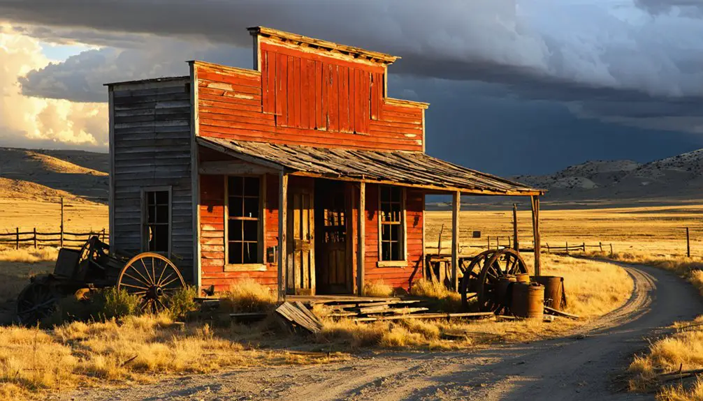
Benton: Wyoming’s First Ghost Town
When the Union Pacific Railroad’s tracks reached milepost 672.1 in Carbon County during the summer of 1868, Benton emerged almost overnight as Wyoming’s first boomtown—and ultimately its first ghost town.
You’d have witnessed Benton’s rise as 3,000 railroad workers flooded this end-of-track settlement, creating a chaotic frontier town with 25 saloons, five dance halls, and a thriving red light district.
Violence ruled the dusty streets where over 100 men died during that wild summer. Whiskey cost less than water, and lawlessness exceeded even Cheyenne’s reputation.
Benton’s fall came just as swiftly—by September 1868, the railroad had moved on, abandoning the town completely. The town served as the railroad terminus for emigrants traveling west, including Mormon families journeying to Utah who would continue their trek on foot or by wagon train.
Within three months, Wyoming’s wildest outpost vanished, leaving only alkali dust and memories. Today, only concrete foundations near Rawlins mark where this infamous settlement once stood.
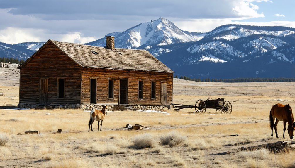
South Pass City: Golden Dreams and Preserved History
After Mormon prospectors struck gold in the Wind River Mountains during summer 1867, South Pass City emerged as Wyoming’s most substantial mining settlement and the heart of the Sweetwater Mining District.
You’ll discover this wasn’t just another mining camp—by 1868, it boasted 1,000 residents, 250 buildings, and a bustling half-mile main street with hotels, newspapers, and saloons.
The Carissa Mine‘s rich vein drove the initial boom, but high extraction costs triggered decline by 1869. When transcontinental railroad routes bypassed the area, gold mining operations couldn’t access necessary equipment.
The last families departed by 1949.
Today’s historical preservation efforts showcase Wyoming’s commitment to freedom and heritage. Since 1966, the state has maintained over 40 original structures and 30,000 artifacts, making it an exceptional example of Western preservation. The town gained additional significance when William Bright introduced Wyoming’s pioneering women’s suffrage legislation here. Visitors can explore the site from late May to mid-October, with guided tours of the historic Carissa Mine available on select days.
Carbon: From Coal Mining to Railroad Abandonment
While South Pass City chased golden fortunes in the mountains, Wyoming’s first coal camp emerged in 1868 to fuel the Union Pacific Railroad’s ambitious transcontinental route.
You’ll find Carbon’s story shaped by dangerous underground work and the relentless pursuit of coal to power steam locomotives across the frontier. The town’s name reflected its primary purpose – extracting carbon-rich coal deposits that had formed over millions of years beneath the Wyoming landscape.
Carbon’s Harsh Realities:
- Mining Disasters claimed 41 miners’ lives, averaging more than one death per year from cave-ins, explosions, and fires.
- Mob justice struck in 1881 when angry miners lynched Dutch Charley Burris for murdering a UP agent and deputy.
- Devastating fires destroyed 20+ downtown buildings in 1890 due to inadequate water supplies.
- Swift abandonment followed mine depletion in 1902, leaving only Carbon’s Legacy of crumbling foundations and a historic cemetery.
Today, Carbon Cemetery stands as the most intact feature of this vanished community, serving as Wyoming’s earliest formal burial ground and preserving the memory of the state’s pioneering coal mining heritage.
Rudefeha/Dillon: Mining Remnants and Open Shafts
You’ll find Rudefeha and its sister town Dillon among Wyoming’s most hazardous ghost towns, where open mine shafts from the early 1900s copper boom remain unfilled and dangerous.
The Ferris-Haggarty Mine‘s remnants include visible structures like the Wolverine mine adit and ore-stamp mill ruins near the old schoolhouse site, fourteen miles from Encampment in the Grand Encampment Mining District. These settlements emerged during the mining boom but became ghost towns after the mining company was indicted for fraudulent stock sales. The mine was connected to processing facilities by a sixteen-mile aerial tram that was the longest in the world when completed in 1902.
Exercise extreme caution when exploring these abandoned settlements, as the mining company never sealed the shafts after operations ceased in 1908.
Abandoned Mining Town Structures
High in the Sierra Madre range at 9,764 feet elevation, the remnants of Rudefeha and Dillon tell the story of Wyoming’s copper boom through scattered mining structures and sealed shafts.
You’ll find traces of a once-thriving operation that housed hundreds of workers in elaborate facilities. The Rudefeha architecture reflects Wyoming’s ambitious mining heritage from the early 1900s.
Dillon formed when alcohol was banned in Rudefeha and was named after Malachi W. Dillon, a miner involved in various ventures.
What remains today includes:
- Sealed mine entrance – Original shaft flooded and secured without proper drainage
- Collapsed building foundations – Two-story boarding house ruins that once accommodated 100 diners
- Tramway terminal remnants – Evidence of the sixteen-mile aerial system to Encampment
- Single abandoned cabin – Occasionally occupied by sheepherders since the 1930s
The extreme elevation on the Continental Divide created severe access challenges, particularly during winter months when State Highway 70 remains closed and early residents required skis or snowshoes for travel.
Stream pollution from mine seepage continues affecting the area’s waterways.
Safety Hazards and Access
Exploring these historic mining remnants requires extreme caution due to numerous life-threatening hazards scattered throughout the Rudefeha and Dillon sites.
You’ll encounter unfilled mineshafts hundreds of feet deep, camouflaged by vegetation and rotting timbers. These open pits cause 20-30 annual U.S. deaths, making safety precautions essential before venturing into this remote Sierra Madre location at 9,764 feet elevation.
Exploration risks include structural instability from decaying ore-stamp mills, toxic contamination from mercury and arsenic used in 1900s processing, and dangerous wildlife like rattlesnakes and mountain lions.
Unstable explosives remain from the 1908 closure, while radon gas accumulates in poorly ventilated tunnels. Access requires traveling Highway 230 south from Saratoga to Encampment, then Highway 70 west, but you’re entering terrain where blizzards once dropped 50 feet of snow.
Fort Steele: Military Outpost Turned Ghost Settlement
You’ll discover Fort Steele’s unique transformation from an essential military installation protecting Union Pacific Railroad workers to one of Wyoming’s most historically significant ghost settlements.
Established in 1868 on the North Platte River’s west bank, this fortress served as a critical defense point against Indian attacks and later housed troops who managed regional law enforcement until its abandonment in 1886.
Today, you can explore the scattered ruins and foundations that remain after decades of fires, vandalism, and natural decay transformed this once-bustling military outpost into a haunting reminder of frontier defense operations.
Military Origins and History
When the Union Pacific Railroad pushed westward across Wyoming Territory in 1868, military protection became essential for workers facing frequent Indian attacks. Fort Fred Steele‘s establishment on June 20, 1868, marked the beginning of significant military importance in Carbon County. Colonel Richard Dodge selected this strategic location on the North Platte River‘s west bank, creating a critical defense post.
You’ll find Fort Steele’s military origins fascinating through these key developments:
- Initial Setup – 300 troops and civilians built permanent structures from an original tent city.
- Strategic Position – Protected the important railroad bridge spanning the North Platte River.
- Supply Hub – Served as regional depot distributing military supplies via rail transport.
- Troop Interactions – Handled labor disputes, law enforcement, and conflicts including the 1879 White River War.
Modern Ruins and Remains
Although Fort Fred Steele‘s military chapter ended in 1886, the site’s story continued through multiple transformations that left distinct archaeological layers across the landscape.
You’ll find cemetery remains scattered across the grounds, where 80 individuals once rested before most bodies were relocated to Fort McPherson, Nebraska.
Today’s surviving structures tell tales of both military and civilian eras. The 1891 powder magazine stands fully intact, while remnants of warehouses and officer’s quarters dot the terrain.
After military abandonment, the Carbon Timber Company transformed the area into a logging hub, floating 1.5 million timbers downriver in 1909.
Later sheep operations added their own buildings—a house, lean-to, and shed that still stand today.
Jireh: Coal Town With Standing Structures
Nestled between Manville and Keeline along Highway 20, Jireh emerged in 1908 as an ambitious Christian college town founded by Reverend George Dalzell on 320 acres of Wyoming prairie.
You’ll discover a community that thrived around Jireh College and experimental dry farming until economic reality struck in the early 1920s.
Today’s remnants tell the story of pioneer determination:
- Prairie View Building – College structure marking educational aspirations
- Business District Ruins – Foundation remains from two banks and general stores
- Jireh Historical Site – Preserved college-related buildings showcasing 1908-1920 peak era
- Historical Markers – Highway 20 interpretive signs detailing the college town’s legacy
The town’s decline began when one bank relocated to Keeline in 1917, signaling dry farming’s inevitable failure across Wyoming’s unforgiving landscape.
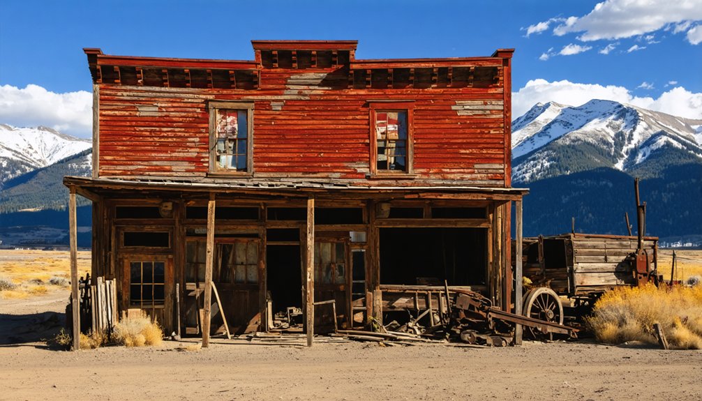
Atlantic City: South Pass Mining Legacy
While Jireh represented Wyoming’s agricultural ambitions, the state’s most significant gold rush unfolded 200 miles southwest in the Wind River Range.
You’ll find Atlantic City’s origins trace to April 15, 1868, when Charles Collins, H.A. Thompson, and Col. Charles W. Tozer made their gold discovery along Atlantic ledge on Rock Creek.
Within a decade, you’re looking at Wyoming’s largest boom, reaching 2,000 residents who built opera houses, breweries, and hotels despite 100-mile isolation from railroads.
The town endured five boom-bust cycles as mining techniques evolved from placer operations to hydraulic methods and dredging.
Today, you’ll encounter 40-57 hardy residents maintaining this Continental Divide community’s legacy.
Kirwin: Remote Mountain Mining Camp
You’ll find Kirwin perched at 9,200 feet in the Absaroka Mountains, where William Kirwin and Harry Adams discovered gold and silver veins in 1885 that sparked Wyoming’s highest-altitude mining boom.
The remote camp grew to house 200 residents and became the state’s most modern mining town, complete with electricity, telephones, and regular stagecoach service to Meeteetse.
Today, you can explore remarkably preserved mining structures that survived the 1907 avalanche disaster, including cabins, mining equipment, and building foundations that tell the story of this ill-fated mountain community.
High Altitude Gold Rush
At an elevation of 9,500 feet in the Absaroka Mountains, Kirwin represents one of Wyoming’s most remote and challenging mining history ventures. This high altitude gold camp emerged when prospectors first arrived in 1870, though the 1868 Shoshone Treaty initially protected the area.
By 1886, Adams and Kirwin successfully staked claims, leading to the Wood River Mining District’s formation in 1891.
The high altitude location created unique challenges:
- Extreme isolation – 40 miles from Meeteetse with stagecoach service every other day
- Harsh weather conditions – Devastating February 1907 avalanche killed three miners
- Difficult ore transport – Mules hauled materials through treacherous mountain terrain
- High operational costs – $1-4 million investments proved uneconomical due to low ore volume
Preserved Mining Structures
Despite decades of abandonment following the catastrophic 1907 avalanche, Kirwin’s mining structures remain remarkably intact at their 9,500-foot elevation in the Absaroka Mountains.
You’ll discover architectural remnants that showcase the town’s peak prosperity, including the three-story Tumlum mine headframe and steam hoist machinery still standing where miners left them.
The historical significance becomes evident as you explore buildings marked by original construction details—heavy electrical appliances, furnace equipment from the assay office, and timber frameworks that once housed 200 residents.
Carl Dunrud’s 1931 purchase preserved these structures from scavenging, maintaining Kirwin’s authenticity.
You’re witnessing Wyoming’s remote mining heritage frozen in time, offering unfiltered glimpses into early 1900s mountain extraction operations.
Jeffrey City: Uranium Boom and Bust

The windswept landscape of central Wyoming conceals one of America’s most dramatic boom-and-bust stories in Jeffrey City, where uranium mining transformed a quiet ranching community into a thriving company town before abandoning it to near-ghost status within decades.
You’ll discover a place where uranium history shaped destinies and modern ghost town resurgence remains elusive.
Jeffrey City’s Rise and Fall:
- Cold War Prosperity – Western Nuclear’s uranium mill processed 8 million tons of ore from 1957-1981, employing over 1,000 workers in a town exceeding 4,000 residents.
- Company Town Luxury – You’d find Olympic-sized pools, separate high schools, and three distinct bars serving different worker classes.
- Sudden Collapse – Market crashes eliminated 95% of the population within three years after 1982 mine closure.
- Environmental Legacy – 321 abandoned uranium mines dot Wyoming, creating ongoing cleanup challenges.
Medicine Bow: Railroad Town Decline
While Jeffrey City’s uranium boom lasted mere decades, Medicine Bow’s story spans over a century of railroad history followed by gradual decline into near-ghost status.
You’ll discover this town began as a general store and saloon in July 1868, strategically positioned before the Union Pacific Railroad‘s arrival. The railroad transformed Medicine Bow into an essential freight center, constructing a five-stable roundhouse and service facilities.
Medicine Bow emerged from humble frontier beginnings in 1868, evolving into a crucial railroad hub through strategic timing and Union Pacific investment.
Peak prosperity came with the 1911 Virginian Hotel and the 1913 Lincoln Highway routing through town.
However, town transformation accelerated when railroad operations declined. Union Pacific closed the depot in 1981 after 68 years of service, eliminating the economic foundation.
Today, you’ll find the historic depot houses a museum, while recent wind farms provide new economic hope for this railroad ghost town.
Frequently Asked Questions
Are There Any Ghost Towns in Wyoming That Are Completely Off-Limits to Visitors?
You won’t find completely off-limits famous ghost towns in Wyoming. Some have restricted access due to private property ownership, but their historical significance guarantees most remain explorable on public lands like forests.
What Safety Equipment Should I Bring When Exploring Wyoming’s Abandoned Mining Sites?
Better safe than sorry—you’ll need hard hats, sturdy boots, gas detectors, and harnesses as essential safety gear. These exploration tips stem from documented mining accidents throughout Wyoming’s 1860s-1950s boom periods when proper equipment prevented fatalities.
Which Ghost Towns Have the Best Preserved Original Buildings and Artifacts?
South Pass City offers you the best historic preservation with 23 original buildings and 30,000 authentic artifacts. You’ll find significant architectural significance in structures like E.A. Slack Cabin and three preserved saloons from the 1860s era.
Are There Guided Tours Available for Wyoming’s Most Dangerous Ghost Town Locations?
While Wyoming’s more “adventurous” ghost town locations like Rudefeha feature hazardous mineshafts, you won’t find guided tours available for these dangerous locations. Tour companies responsibly focus on safer, accessible sites like Kirwin and Superior instead.
What Is the Best Time of Year to Visit Wyoming Ghost Towns?
You’ll find the best seasons for Wyoming ghost towns span late spring through early fall when weather conditions allow safe access. Halloween season’s ideal for Sweetwater County sites, while winter snow blocks elevated locations.
References
- https://www.wyomingcarboncounty.com/blog/123-5-ghost-towns-to-explore
- https://www.onlyinyourstate.com/experiences/wyoming/creepy-ghost-towns-in-wy
- https://www.youtube.com/watch?v=GEoxbcwf8Ks
- https://sites.rootsweb.com/~wytttp/ghosttowns.htm
- http://userpages.aug.com/bdobson/ghost4.html
- https://en.wikipedia.org/wiki/List_of_ghost_towns_in_Wyoming
- https://ithorsted.com/history/denmark-to-utah/august-25-1868/
- https://kingfm.com/the-legend-of-benton-wyomings-wildest-town/
- https://www.gatheringgardiners.com/2010/11/benton-wyoming.html
- http://userpages.aug.com/bdobson/photos9.html