You’ll discover Flanigan as a fascinating railroad ghost town established in 1909 by Western Pacific Railroad in Nevada’s Honey Lake Valley. Located just 5 miles east of the California border, it emerged as a promising junction when Southern Pacific added its Fernley & Lassen branch in 1912. Despite ambitious plans for a 30-block townsite, water scarcity and failed development dreams led to its abandonment by the 1970s. The site’s rugged desert landscape holds untold stories of railroad rivalries and western speculation.
Key Takeaways
- Flanigan was established in 1909 as a railroad junction town, named after Patrick L. Flanigan who provided land rights.
- The town failed primarily due to water scarcity, with residents forced to rely on railroad-shipped water supplies.
- At its peak, Flanigan had 200 residents, a 40-room hotel, general store, and post office serving railroad workers.
- The town’s decline began in the 1960s with the post office closure and decreased railroad activity.
- By the 1970s, Flanigan was completely abandoned after fires, school closure, and dismantling of the rail line.
The Birth of a Railroad Station
When the Western Pacific Railroad began constructing its Feather River Route between Oakland and Salt Lake City in 1909, they established Flanigan Station, naming it after Patrick L. Flanigan, a local businessman who provided the essential right of way for the tracks.
The station’s significance grew dramatically in 1912-1913 when Southern Pacific built their Fernley & Lassen branch, creating an important rail intersection. Similar to other entries in the surname disambiguation page, Flanigan’s name became permanently linked to this location.
While early development saw only sporadic activity between 1910-1911 and 1919-1920, the official townsite deed filed on July 16, 1913, marked a turning point. Real estate promoters attracted numerous buyers with plans for a transportation hub featuring over 900 lots.
You’ll find that this intersection of major rail lines prompted substantial infrastructure development, including a signal maintainer house, two bunk houses, and a 24-foot-high signal tower to manage the increasing cross-line traffic.
Location and Natural Setting
You’ll find Flanigan’s remains in Nevada’s Honey Lake Valley, positioned at 4,006 feet elevation and roughly 5 miles east of the California border.
The ghost town sits at coordinates 40.17162° N, -119.89407° W, within Washoe County’s high desert terrain characterized by the Great Basin‘s distinctive basin-and-range topography. This remote area consists of 5.00 acres of undeveloped land.
The surrounding landscape features typical desert vegetation, while nearby landmarks include Pyramid Lake to the east and the Fort Sage Off-Highway Vehicle Area about 13 miles away. The area’s geography features several historical localities including Double Check, situated 5 miles to the northeast.
Geographic Position Details
The ghost town of Flanigan sits at coordinates 40.17° N, -119.89° W in northern Nevada’s Honey Lake Valley, perched at an elevation of 4,006 feet above sea level. This geographic significance places you just 5 miles from the California border, where altitude effects contribute to the region’s semi-arid climate and distinctive sagebrush landscape. Today, the area encompasses 5.00 acres of historically significant land. Satellite imagery reveals the precise layout of this remote ghost town.
Exploring ghost towns in Nevada offers a unique glimpse into the past, where abandoned structures and relics of history tell tales of bygone eras. Each visit to these sites can evoke a sense of adventure and curiosity, inviting you to uncover the mysteries behind their decline. As you wander through the remnants, the haunting beauty of the landscape serves as a poignant reminder of the lives once lived there.
- You’ll find yourself in Washoe County, nestled within the broader Sierra Nevada region.
- The townsite’s position near Pyramid Lake provides a striking natural landmark to the east.
- You’re about 6 miles east of Calneva, California, a small community on the state line.
- The area’s moderate elevation creates unique weather patterns typical of Great Basin geography.
- The location offers unobstructed views of wide-open skies and valley vistas characteristic of the region.
Desert Environment Features
Situated within a harsh desert environment, Flanigan’s natural setting exemplifies the challenging conditions of Nevada’s high desert ecosystem.
You’ll find alkali flats dominating the landscape, where high salt content severely limits vegetation diversity. The area receives only five inches of rainfall annually, while temperatures swing dramatically from scorching 130°F summers to freezing winters. Water conservation practices remain vital for the region’s sustainability.
Native desert adaptations are evident in the scattered sagebrush and other xerophytic plants you’ll encounter, which have evolved specialized features like waxy coatings to survive extreme conditions. The harsh climate is intensified by the rain shadow effect created by surrounding mountain ranges.
The region’s water sources are primarily underground, with the Flanigan Playa – a dry lakebed – serving as the nearest significant geological feature.
The fragile ecosystem’s recovery from disturbance can take centuries, making preservation of this unique desert environment essential.
Railroad Junction Development
You’ll find Flanigan’s origins tied directly to Western Pacific Railroad‘s 1909 establishment of a station in eastern Honey Lake Valley, named after rancher and former Nevada State Senator Patrick L. Flanigan.
The junction’s significance grew in 1912-1913 when Southern Pacific Railroad constructed its Fernley & Lassen branch line, crossing Western Pacific’s tracks and creating a connection point between two major rail routes.
Despite early optimism and land speculation promoting Flanigan as a future transportation hub, the town never achieved its anticipated prominence as a major rail center. On July 22, 1913, Charles Ross and Warnken officially recorded the Flanigan Townsite, marking a pivotal moment in the settlement’s development. By 1914, the growing settlement featured a post office and hotel, serving the small but hopeful community.
Strategic Rail Line Location
When Western Pacific Railroad established Flanigan in 1909, they strategically positioned the station along their Feather River Route connecting Oakland to Salt Lake City.
The railroad significance grew when Southern Pacific’s Fernley & Lassen branch crossed the tracks in 1912-1913, creating an essential junction legacy in eastern Honey Lake Valley.
- You’ll find Flanigan’s location was carefully chosen as a prospective rail center for the region.
- The junction became critical for shipping livestock and wool from Patrick L. Flanigan’s vast ranchlands.
- Railroad employees made up most of the town’s population, peaking in the 1920s.
- The crossing enhanced transport options between Reno and Honey Lake Valley.
- Plans for a third rail line, the Surprise Valley Railway, were considered but never materialized.
Junction Construction Timeline
The construction of Flanigan’s railroad junction unfolded across a four-year period from 1909 to 1913, transforming the site from a simple Western Pacific station into a strategic two-railroad crossing.
You’ll find the junction timeline began when Western Pacific established its initial station in January 1910, though it mysteriously disappeared by 1911.
The real turning point came in 1912 when railroad competition intensified – Southern Pacific launched construction of its Fernley & Lassen line, erecting buildings later that year.
By 1913, the junction was complete with Southern Pacific’s new station, creating a crucial crossing point between the two major railways.
The timing proved perfect for promoters Ross & Warnken, who officially recorded the townsite in July 1913, hoping to capitalize on the junction’s potential.
Failed Transportation Hub Vision
Despite the promising start of the railroad junction‘s construction, Flanigan’s grand vision as a major transportation hub never materialized. The intersection of two major rail lines sparked ambitious transportation dreams, but economic limitations and environmental challenges proved insurmountable.
You’ll find that despite speculation of explosive growth, the town never exceeded fifty permanent residents.
- Water scarcity forced dependence on rail-shipped water supplies
- The promised Surprise Valley Railway connection never materialized
- Failed natural resource ventures prevented economic diversification
- Southern Pacific’s 1959 station closure diminished the junction’s importance
- Limited agricultural potential restricted sustainable development
Land Speculation and Early Growth
In 1913, Oakland-based land speculators Charles A. Ross and George L. Warnken purchased land west of Flanigan’s railroad crossing, plotting an ambitious 30-block townsite with over 900 lots.
You’ll find they targeted California investors through aggressive marketing campaigns, selling lots to buyers who’d never seen the property. Their plans included a school, library, and two-block commercial district.
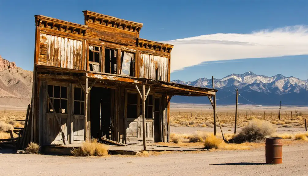
Paul Butler, their hired promoter, fueled investor hype by building a 40-room hotel and hosting potential buyers.
The speculation reached fever pitch when local media suggested Flanigan might rival Reno.
However, they’d hidden a significant flaw – their claims of potable water wells were false. The water’s high salinity forced dependence on railroad water supplies, ultimately undermining the town’s growth potential despite selling over 200 lots.
Daily Life in Flanigan’s Peak Years
While land speculators painted grand visions of Flanigan’s future, daily reality proved far more modest during the town’s peak years from the 1910s to 1920s.
You’d find a tight-knit community of around 200 residents, mostly railroad workers and their families, who relied heavily on the town’s few key establishments for daily routines and community gatherings.
- The 40-room Hotel Flanigan served as temporary housing for railroad workers and travelers.
- You’d need to collect your shipped-in water supply since local wells were too saline for use.
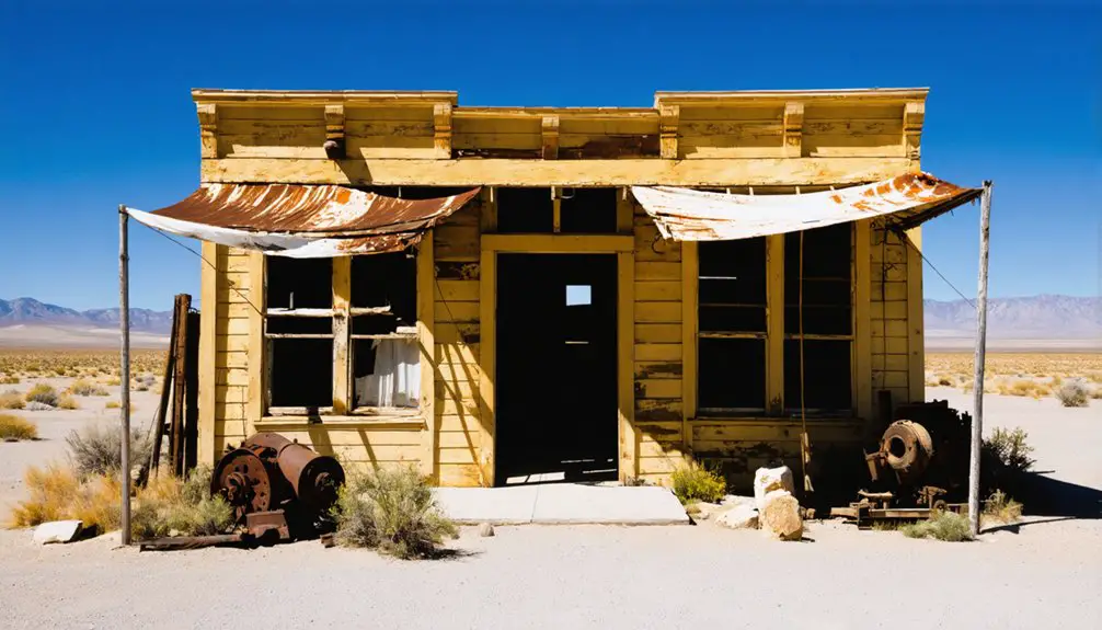
- The general store and post office formed the heart of social interactions and essential supplies.
- Daily life revolved around railroad schedules, with workers coming and going.
- Community gatherings centered at these few established locations, as planned amenities like schools never materialized.
Water Challenges and Failed Promises
Although Flanigan’s promoters advertised the town as a promising hub with abundant water resources, the harsh reality of its water challenges quickly emerged. Early drilling attempts revealed highly saline, undrinkable water, forcing residents to rely on railroad deliveries for their daily needs.
Despite grand promises of plentiful water, Flanigan’s wells produced only undrinkable brine, leaving residents dependent on railroad water shipments.
You’ll find that this water scarcity severely limited the town’s growth, keeping the population under fifty despite plans for over 900 lots.
The failed infrastructure promises hit particularly hard when agricultural development proved impossible without reliable irrigation. While other Nevada settlements benefited from federal water projects and regional pipelines, Flanigan remained isolated.
The town’s developers, Charles A. Ross and George L. Warnken, had sold a dream that couldn’t overcome the fundamental lack of potable water, ultimately contributing to Flanigan’s descent into ghost town status.
The Town’s Gradual Abandonment
The gradual abandonment of Flanigan began with its diminishing importance as a railroad hub.
You’ll find that population decline accelerated in the 1960s when railroad companies removed their crews and facilities. The town’s abandonment reasons multiplied as vital services disappeared one by one.
- The post office closed in 1961, marking the beginning of municipal decline
- Crews and railroad facilities were removed throughout the 1960s
- The last operating one-room school in Washoe County shut down in 1969
- A devastating fire in 1969 destroyed the town’s final store and residence
- By the 1970s, the significant Fernley & Lassen rail line was completely dismantled
Even attempts to revive Flanigan as a novelty ghost town failed when the Interstate Land Sales Full Disclosure Act made development financially impossible.
What Remains Today
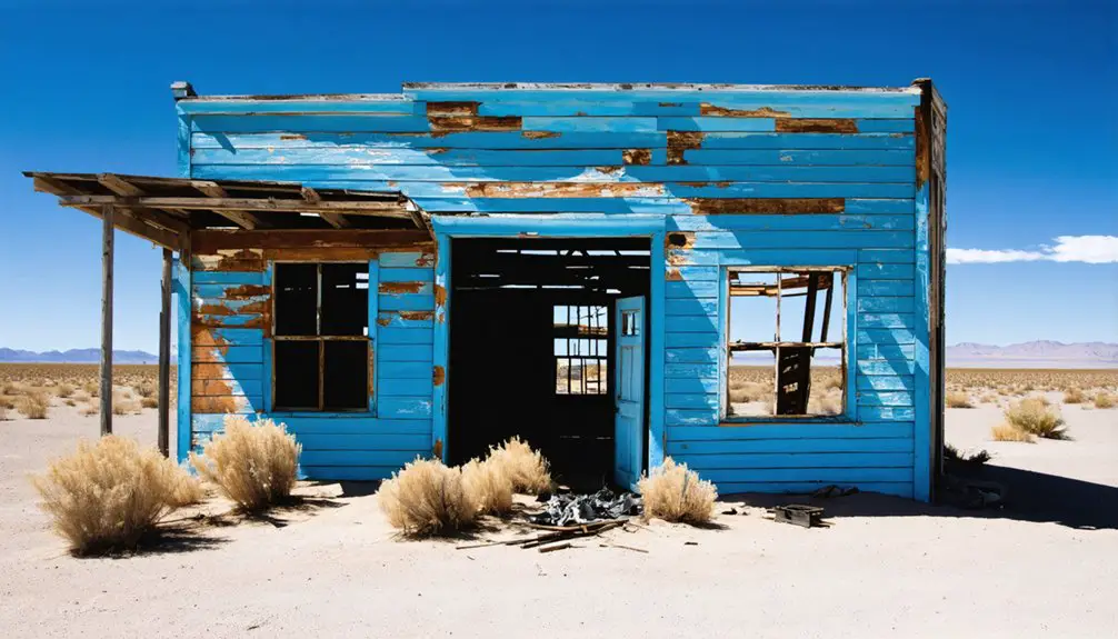
Standing at Flanigan’s former location today, you’ll find little more than scattered concrete foundations and desert vegetation where this once-bustling railroad town stood.
Time and desert winds have reduced this once-thriving railroad community to mere concrete slabs and scattered brush.
A remnants assessment reveals how nature has reclaimed the site, with sagebrush and native grasses covering most traces of human habitation. The surrounding high desert landscape, including the nearby Flanigan Playa, has steadily eroded the community’s legacy.
The town’s final chapter closed dramatically when a 1985 wildfire destroyed the last remaining structures.
You can still trace the original town layout through visible concrete foundations, though the general store and post office – destroyed by fire in 1969 – exist only in memory. The Bonham School building, once a vibrant community center, was relocated before the town’s complete abandonment.
Frequently Asked Questions
Are There Any Documented Accidents or Deaths That Occurred in Flanigan?
You won’t find documented deaths or accidental incidents in Flanigan’s records, except for the 1969 store fire that burned down while unoccupied, forcing the last resident to leave town.
What Wildlife Species Were Commonly Found in the Flanigan Area?
Ever wonder what roams the high desert? You’ll find incredible wildlife diversity here – from coyotes, mountain lions, and mule deer to golden eagles and burrowing owls, all thriving in their preserved habitat.
Did Any Notable Criminals or Outlaws Pass Through Flanigan?
You won’t find any documented outlaw sightings or criminal activities in Flanigan’s history. The small railroad town’s population consisted mainly of workers and families, with no notable outlaws passing through.
What Was the Average Property Value of Lots During Flanigan’s Peak?
You won’t find exact historical valuation records for Flanigan’s peak property market. While lots sold actively in 1913-1914, and later went for $200-300 in the 1970s, peak-era prices remain unknown.
Were There Any Native American Settlements Near Flanigan Before Its Establishment?
You’ll find the Washoe and Northern Paiute peoples seasonally inhabited this culturally significant region, using it for hunting and gathering. While no permanent Native American settlements existed specifically at Flanigan, they frequented the area.
References
- https://en.wikipedia.org/wiki/Flanigan
- https://tipurdy.org/flanigan-the-grandiose-ghost-of-honey-lake-valley/
- http://backyardtraveler.blogspot.com/2023/11/washoe-county-ghost-town-of-flanigan.html
- https://www.nvexpeditions.com/washoe/flanigan.php
- https://en.wikipedia.org/wiki/List_of_ghost_towns_in_Nevada
- https://nvtami.com/2024/01/23/northern-washoe-county-ghost-towns-2/
- https://mapcarta.com/23753516
- https://www.nystatemls.com/property/11219974/?listshare=7AD7UIJY7YGKROVOU5CFMZCOJGBB77QADHJULFFNT6L3KTY
- https://en.wikipedia.org/wiki/Panamint_City
- https://www.gotraveltop.com/maps/nevada-satellites.php?map=Flanigan


