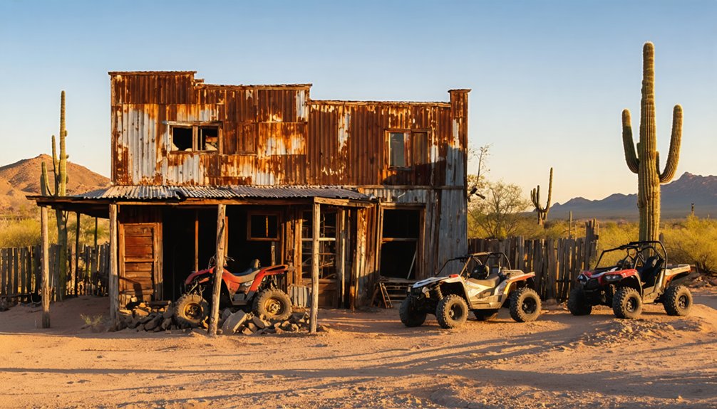
You’ll find excellent ATV access to Arizona’s ghost towns through established trail networks like the 34-mile Ghost Town Trail connecting Tombstone to Gleeson, Courtland, and Pearce via historic stagecoach routes. The 675-mile Arizona Peace Trail links Swansea’s copper mining ruins, while Signal Ghost Town Trail offers 18.7 miles of county-maintained desert routes. Crown King’s challenging 25-mile approach demands experienced drivers and proper vehicle preparation. These well-graded dirt roads follow original mining paths, providing authentic exploration opportunities that reveal Arizona’s extensive backcountry mining heritage.
Key Takeaways
- The 34-mile Ghost Town Trail connects Tombstone to three abandoned mining communities via well-graded dirt roads suitable for ATVs.
- Swansea Ghost Town offers copper mining ruins accessible via the Arizona Peace Trail, located 30 miles east of Parker.
- Signal Ghost Town Trail provides an 18.7-mile point-to-point route along maintained county roads in southern Mohave County.
- Crown King and surrounding ghost towns like Bumble Bee and Cleator are accessible via historic 25-mile routes requiring experienced drivers.
- The 675-mile Arizona Peace Trail connects multiple ghost towns across western Arizona with graded roads and technical ATV sections.
Ghost Town Trail: Journey From Tombstone to Historic Mining Communities
The 34-mile Ghost Town Trail connects Tombstone to three abandoned mining communities through well-graded dirt roads that’ll challenge your ATV skills while delivering authentic Arizona history.
Experience 34 miles of rugged desert trails linking Tombstone’s legendary past to three forgotten mining ghost towns.
You’ll navigate from State Route 80 east of Tombstone onto Camino San Rafael, then follow Gleeson Road for 14 miles to the main Ghost Town Trail route. This historic path traces the original 1870s-1880s stagecoach road between Fort Bowie and Fort Huachuca, taking you through Dragoon Mountains scrub terrain.
Your ATV Adventures will encounter uneven surfaces, old mining roads, and remnants from boom-era operations.
The well-maintained dirt road accommodates ATVs effectively while preserving access to authentic Ghost Towns like Gleeson, Courtland, and Pearce. In Gleeson, you can explore the historic jail built in 1910, now restored and open to the public. The town’s mining heritage includes the Copper Belle Mine, which was opened by John Gleeson and led to an influx of miners during the early 1900s boom period.
Expect mining gates blocking active areas and concrete foundations marking former settlements throughout this freedom-focused backcountry experience.
Swansea Ghost Town: Copper Mining Ruins Along the Arizona Peace Trail
While traversing the Arizona Peace Trail’s rugged terrain, you’ll discover Swansea Ghost Town‘s extensive copper mining ruins scattered across 30 miles of challenging backcountry east of Parker.
This Bureau of Land Management site requires ATV navigation through remote desert terrain to access well-preserved industrial remnants from Arizona’s copper boom era.
Swansea history spans 1909-1937, when the Clara Consolidated Mining Company operated a 700-ton smelter producing 50 tons of copper matte daily.
You’ll encounter smelter foundations, railroad grades, and sealed mine shafts reflecting advanced mining techniques of the early 1900s. The town was named after George Mitchell’s hometown in Wales when the silver lead ore deposit was first developed.
The BLM has installed interpretive plaques and secured dangerous excavations for rider safety. The town reached its peak population of 750 residents during the height of copper mining operations.
Navigate carefully around restored ruins and respect the two historic cemeteries marking this significant copper mining heritage site.
Signal Ghost Town Trail: Narrow Path Adventures to Desert Remnants
Moving southeast from the Arizona Peace Trail’s copper mining heritage, you’ll encounter Signal Ghost Town Trail‘s 18.7-mile point-to-point route along Signal Road in southern Mohave County.
This maintained county road provides year-round access to remote Sonoran and Mojave Desert junction near Artillery Mountains. Your ATV exploration leads to Old Signal Ghost Town remnants, where silver mining operations flourished during post-California Gold Rush era.
The Signal Trail requires standard safety protocols: carry abundant water, monitor weather conditions, and travel with companions. Inform others of your itinerary before departing.
GPS navigation assists with route planning through this seldom-visited terrain. You’ll discover abandoned mine structures, foundations, and artifacts from the historic Signal Mine. The trail crosses the Big Sandy River at two water crossings, which may become impassable during rainy conditions when water depth exceeds safe levels.
Multiple mapping services provide detailed satellite imagery and routing features to help visualize the terrain before your arrival. The narrow path adventure combines off-road freedom with preserved 19th-century mining history in Arizona’s remote backcountry.
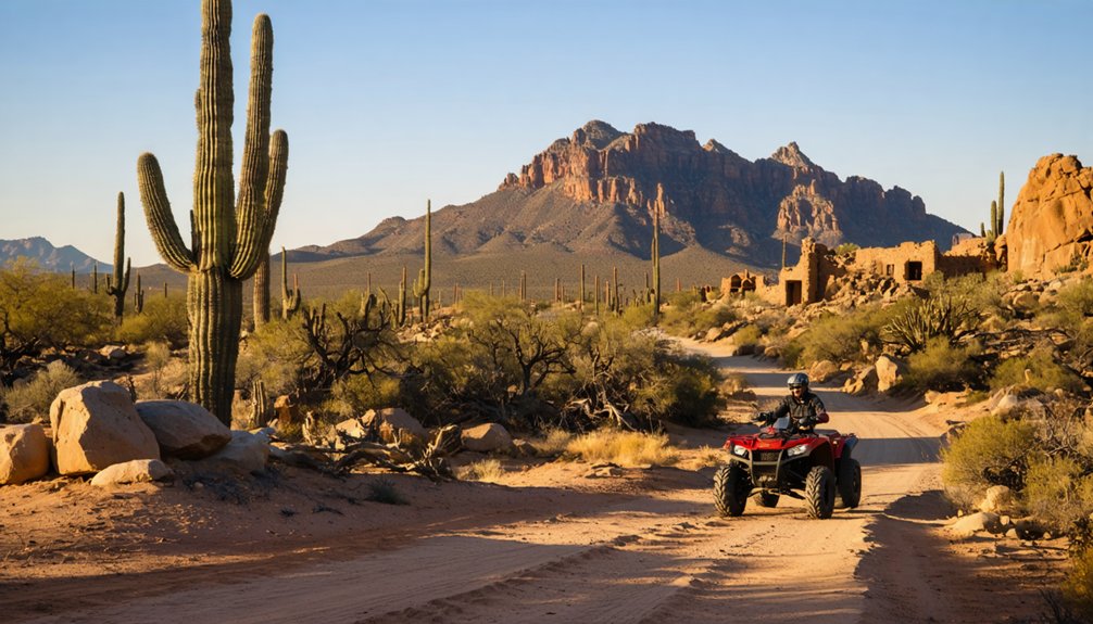
Tonopah Ghost Town Tour: Racing Stagecoach Routes to Gold Mine Sites
Following Highway 95 north from Signal’s remote mining remnants, you’ll access Tonopah’s historic gold and silver district where Jim Butler’s 1900 discovery transformed a remote desert spring into Nevada’s richest mining camp.
Your ATV route follows original stagecoach paths to three primary mining sites: Mizpah Mine northwest from the visitor center, Silver Top Mine south with its preserved hoist house, and Desert Queen Mine uphill from Tonopah Mining Park.
Navigate carefully around the 1922 Glory Hole collapse near Mizpah workings.
Tonopah history includes $150 million in precious metal extraction through 1948.
Exercise extreme caution near Old Tonopah Cemetery and abandoned mine shafts where visitors report ghostly encounters. The historic Mizpah Hotel stands as a testament to the town’s boom era and continues to draw paranormal enthusiasts to this day. Visitors exploring the cemetery should be aware that graves of Bina Verrault and George “Devil” Davis are located within the burial grounds.
Maintain safe distances from unstable structures and vertical drops throughout the district.
Box Canyon and Crown King: Hassayampa Region Mining History
You’ll navigate challenging terrain when accessing Crown King’s historic mining district, where the Crowned King Mine operated from the 1890s with a 10-stamp mill processing 30 tons of ore daily.
The route follows sections of the old Bradshaw Mountain Railway grade, featuring steep switchbacks and elevation changes from 4,400 to 5,835 feet that require proper ATV preparation and experienced riding skills. The railroad’s nine switchbacks helped trains navigate the dramatic elevation changes before operations ceased in 1926.
Operations faced significant challenges including a devastating February 1890 storm that caused major damage and financial losses to the mining infrastructure. Maintain reduced speeds through Box Canyon approaches, as loose rock conditions and narrow passages demand constant attention to vehicle positioning and trail awareness.
Historic Mining Operations
While traversing the rugged ATV trails of Arizona’s Hassayampa region, you’ll encounter remnants of mining operations that shaped this desert landscape for over a century.
Box Canyon Mine, discovered in 1954 at 2,402 feet elevation, sits inactive near Wickenburg in Yavapai County. The Mistake Mine operated both surface and underground manganese extraction until closure.
Martinez Mining operations dominated the late 1880s silver boom, with Martinez Mine running from 1880 to 1971 in steep, remote canyon terrain.
You’ll find this site preserved in original condition, accessible via Cottonwood and Box Canyon routes.
The Meyers Mine, part of the Box Canyon group, produced from 1926 to 1954 under multiple operators including the Meyers brothers, J.J. Jackson, and C.W. Gardner.
Crown King Access
Beyond the scattered mining ruins lies the Crown King trail system, Arizona’s most challenging and popular 4×4 route that demands experienced drivers and proper vehicle preparation.
This 25-mile historic route traverses the Bradshaw Mountains, connecting Lake Pleasant to Crown King’s old mining town through steep, rocky terrain lacking bypasses.
You’ll need street-legal vehicles on Cow Creek Road sections, while non-street-legal ATVs can operate within Prescott National Forest boundaries.
The trail’s historical significance stems from its mining heritage, passing ghost towns Bumble Bee and Cleator.
These scenic routes offer wildlife viewing opportunities but require extreme caution due to rough, ever-changing conditions.
ATV regulations mandate 50-inch width limits, with spotter assistance recommended for boulder-strewn creek crossings.
Lake Pleasant Area: Hieroglyphic Mountain Backcountry Exploration
Straddling Maricopa and Yavapai counties, the Hieroglyphic Mountains offer technical backcountry access through the Boulders OHV Staging Area, positioned 45 miles north of downtown Phoenix.
The 14.7-mile Hieroglyphic Mountain Loop challenges your 50-inch ATV with steep rollercoaster terrain and one ledge climb that’ll test stock vehicles. You’ll navigate blind hilltops requiring heightened awareness and technical precision. Desert vegetation causes pinstriping, so protective gear’s essential for ATV navigation through this rugged landscape.
Peak 3465 rewards your effort with panoramic views spanning Lake Pleasant, Hells Canyon, and Bradshaw Mountains. Most obstacles offer bypasses, maintaining accessibility while preserving adventure.
Spring, fall, and winter provide ideal riding conditions. The Hieroglyphic Mountains connect to Pioneer Pass and Alpine Memorial Overlook, expanding your backcountry exploration options beyond traditional ghost town routes.
Sycamore Creek Trails: Sandy Pathways to Sugarloaf Mountain Views
You’ll navigate 11.7 miles of sandy wash canyons and steep hill climbs through the Sycamore Creek trail network, where constantly changing ruts and washouts demand high-clearance 4×4 or modified ATV capabilities.
The northern loop presents extreme technical challenges with 3.5-foot vertical ledges and washed-out sections that require skilled driving and appropriate vehicle modifications.
Beyond waypoint 4, you’ll access scenic viewpoints toward Sugarloaf Mountain while managing puddles during wet seasons that can render sections impassable.
Twenty miles of sandy creek bed routes wind through Sycamore Creek’s trail system, demanding specific navigation techniques for safe ATV passage.
You’ll encounter dynamic conditions where occasional water flows transform the terrain, requiring constant assessment of sandy navigation challenges during your creek adventure.
The dry creek bed offers ideal riding conditions, but you must master these essential techniques:
- Momentum control – Maintain steady throttle through deep sand sections to prevent getting stuck
- Line selection – Choose the firmest packed sand along wash edges rather than loose center channels
- Weight distribution – Shift your body weight rearward when climbing sandy inclines to maintain traction
Sandy pathways in these low-lying washes connect you to technical trail sections beyond the main creek, extending your backcountry exploration through upper Sonoran Desert terrain toward distant mountain views.
Sugarloaf Mountain Viewpoints
Beyond the sandy creek bed navigation, Sugarloaf Mountain’s 3,879-foot summit provides commanding viewpoints accessible through Tonto National Forest’s ATV-friendly trail network.
You’ll encounter moderate terrain with 1,000 feet of elevation gain over SAC 1-classified paths suitable for all skill levels. The sandy pathways connecting to Sugarloaf vistas offer two-hour excursions through non-technical terrain near Spur Cross boundary.
Your ATV excursions benefit from the mountain’s 499-foot prominence, delivering panoramic overlooks from overhanging cliffs.
Starting elevation reaches 6,480 feet on the east side, where trails wind around the peak through wilderness settings. You’ll navigate easily-followed routes that maintain beginner-friendly standards while accessing ghost town regions.
The moderate demands accommodate any fitness level during these recreational pursuits.
Arizona Peace Trail: 750-Mile Desert Adventure Through Ghost Towns
Spanning 675 miles across western Arizona’s most remote terrain, the Arizona Peace Trail (AZPT) connects multiple historic ghost towns through a challenging network of graded roads, technical rock crawling sections, and steep hill climbs designed specifically for OHV vehicles.
You’ll navigate 32-34 segments linking Chloride’s mining heritage with Gold Eye Mine and Museum while traversing elevations from 170 feet at Colorado River to 7,070 feet in snow-prone Hualapai Mountains.
Essential trail considerations include:
- Seasonal timing: October-May ideal; avoid 110°F+ summer temperatures
- Navigation resources: AZPT Atlas provides segment maps, difficulty ratings, GPX files
- Wildlife encounters: Desert Wildlife requires respectful distance in Sonoran ecosystem
The Peace Trail demands technical riding skills while offering unparalleled access to Arizona’s forgotten mining communities and archaeological sites.
Cleator and Prescott National Forest: Hidden Mining Camp Discoveries

Nestled within Prescott National Forest‘s rugged Bradshaw Mountains, Cleator represents one of Arizona’s most accessible ghost town destinations via FSR 259, requiring only moderate ATV navigation skills through eight miles of maintained dirt roads from Bumblebee.
You’ll traverse Murphy’s Impossible Railroad route through Cedar Canyon, following the historic supply line that connected Prescott to Crown King mines until 1933.
Cleator history dates to 1864’s Turkey Creek mining district, serving the Desoto, Silver Pheasant, and Swastika operations.
Historic mining operations including the Desoto, Silver Pheasant, and Swastika mines shaped Cleator’s identity since 1864’s Turkey Creek district establishment.
Today’s mining heritage remains visible through WPA-era stone schoolhouse, operational Cleator Bar, and restored cabin structures.
Eleven residents maintain this near-ghost town at 4,000-foot elevation, offering authentic Old West atmosphere without urban interference.
Fresh water drilling guarantees reliable resupply stops.
Bouse Ghost Riders Territory: Remote Southwest Landscape Exploration
While Cleator offers mountain terrain exploration, southwestern Arizona’s Bouse Ghost Riders territory provides extensive desert riding across the Arizona Peace Trail‘s 210-mile corridor connecting Bullhead City to Yuma.
You’ll traverse remote landscapes incorporating old mining roads and dirt tracks managed through multi-agency coordination across federal, state, and private lands.
Your Bouse adventures access extensive trail systems spanning multiple counties:
- Swansea Historic Ghost Town – BLM-managed site with post-and-cable boundaries near Parker 400 spectator areas
- Quartzsite staging area – 26 pull-thru spots with restrooms, security lighting, and camp host services
- Laguna Ridge section – 14.2-mile challenging ridge line with steep climbs through desert hills
You’ll need permits for Barry Goldwater Air Force Range crossings.
The club emphasizes safety education, conservation practices, and land protection while promoting winter visitor recreation opportunities.
Frequently Asked Questions
What ATV Safety Gear and Equipment Should I Bring for Ghost Town Exploration?
You’ll need life-saving essential gear: DOT helmet, eye protection, gloves, boots, long sleeves. Pack first-aid, extra water, emergency supplies. Follow ATV maintenance tips—check brakes, lights, spark arrestor before hitting remote ghost-town trails.
Do I Need Permits or Special Licenses to Ride ATVS in Arizona?
You’ll need an Arizona OHV decal ($25 annually) and complete mandatory safety training starting 2025. ATV regulations require valid driver’s licenses on public roads, with riding age restrictions prohibiting under-16 operators on highways.
What’s the Best Time of Year to Visit Arizona Ghost Towns by ATV?
Fall through spring offer ideal riding conditions for ghost town exploration. You’ll avoid dangerous summer heat and monsoon flash floods while enjoying cooler temperatures and enhanced visibility on technical desert trails.
Are There Guided ATV Tours Available for Arizona Ghost Town Exploration?
You’ll find several guided tour options exploring Arizona’s “dearly departed” settlements, including Tip Top, Jerome, Wickenburg, and Tonopah adventures. These professional operators provide safety equipment, desert-rated UTVs, and thorough ghost town history while accessing remote backcountry trails.
Another fascinating destination to consider is the history of Helvetia, Arizona, where you can uncover the stories of early settlers and mining endeavors. Visiting these historic sites not only offers a glimpse into the past but also showcases the stunning landscapes that framed their lives. As you explore, be prepared to experience the authentic remnants of the Wild West, nestled amidst breathtaking desert scenery.
What Should I Do if My ATV Breaks Down in Remote Areas?
Signal your location using emergency communication devices, then assess mechanical issues systematically. Prioritize breakdown prevention through pre-ride inspections and carrying essential repair tools for remote trail scenarios where self-reliance determines your safe return.
References
- https://thearizonabucketlist.com/ghost-town-trail-atv/
- https://www.youtube.com/watch?v=Xv9v-xRS_3I
- https://azstateparks.com/central-az-ohv-trailheads
- https://www.tripadvisor.com/Attraction_Review-g31301-d7645184-Reviews-Swansea_Ghost_Town-Parker_Arizona.html
- https://www.visitarizona.com/like-a-local/tour-the-terrain-off-roading-in-arizona
- https://www.onxmaps.com/offroad/trails/us/arizona/signal-ghost-town-trail
- https://app.advcollective.com/local-experts/ghosttown-tour
- https://apachetrailtours.com
- https://www.riderplanet-usa.com/atv/trails/info/arizona_10328/ride_de48.htm
- https://www.arizonahighways.com/ghost-town-trail


