You’ll find New Hampshire’s most enchanting ghost towns deep in the White Mountains, where ATV trails lead to Livermore’s abandoned sawmill foundations and forgotten schoolhouse ruins. Ride through Pisgah State Park‘s network of historic mill sites, or explore Jericho Mountain State Park’s 70+ miles of trails accessing remote settlements unreachable by car. The Passaconaway Historic District offers easier access along the Kancamagus Highway, while Gorham connects you to over 1,000 miles of backcountry exploration opportunities through these haunting remnants of 19th-century communities.
Key Takeaways
- Livermore ghost town in White Mountain National Forest features sawmill and school foundations from a 1900-era logging community.
- Jericho Mountain State Park offers 70+ miles of ATV trails accessing remote ghost town sites unreachable by car.
- Pisgah State Park contains abandoned homesteads and mill ruins from 19th-century settlements accessible via ATV trails.
- Gorham serves as an ATV hub connecting to 1,000+ miles of trails through the Ride the Wilds system.
- Lower Stillwater Chair Factory and Ashuelot Village ruins are accessible through designated backcountry ATV trail networks.
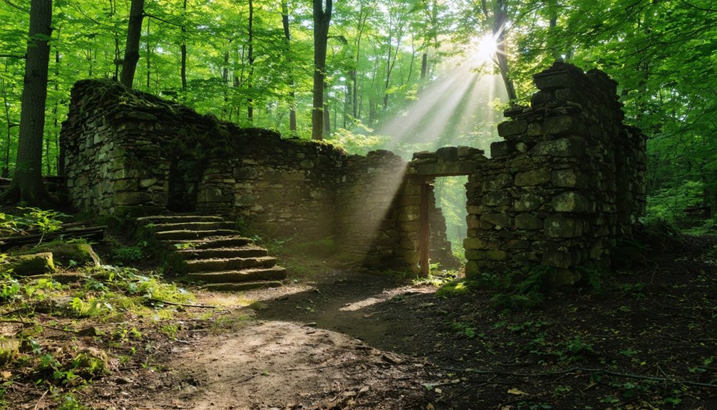
Livermore: A White Mountains Settlement Lost to Time
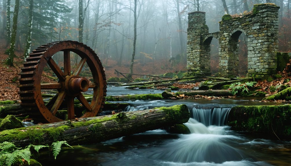
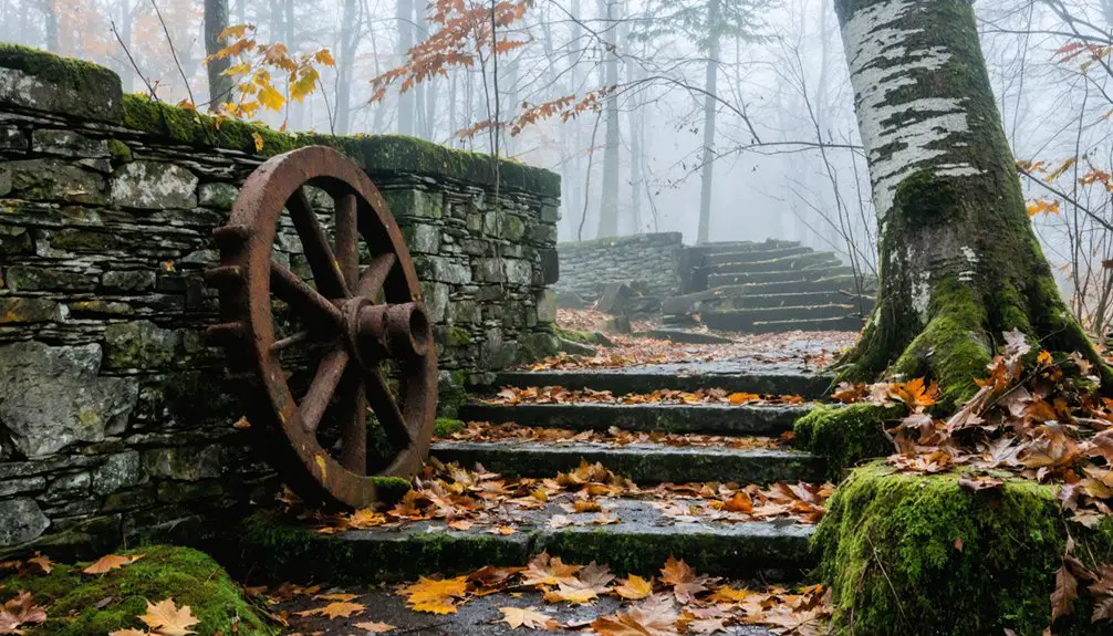
Deep in the White Mountain National Forest, the ghost town of Livermore beckons ATV enthusiasts with its haunting collection of stone foundations and scattered ruins.
You’ll access this forgotten settlement via Sawyer River Road, where your machine can navigate the terrain that once bustled with 150-200 residents during its 1900 peak.
Livermore history reveals a logging empire established in 1876 by Boston’s Saunders family.
You’ll discover remnants of their sawmill, school foundations, and the brick chimney from their power plant.
Multiple fires and floods eventually claimed this White Mountains community by 1951. A devastating flood in the 1920s destroyed the mill and triggered the town’s final decline.
Your ghost town exploration uncovers scattered debris—glass, metal pipes, and horseshoes—telling stories of itinerant lumberjacks who called this sawdust-covered settlement home.
Railroad bridge stanchions still span the Sawyer River, marking where prosperity once flowed. The town was named after Samuel Livermore, a New Hampshire senator related to the founding Saunders family.
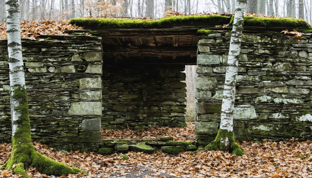
Pisgah State Park’s Abandoned Homesteads and Mill Sites
You’ll find some of New Hampshire’s most haunting remnants at Pisgah State Park, where abandoned homesteads and mill sites tell stories of a once-thriving 19th-century community.
The William Davis Homestead ruins offer a perfect starting point for your exploration, with crumbling cellar holes and weathered stone foundations marking where families carved out lives from the wilderness. Old growth pine and hardwood trees that once dominated this landscape were cleared by early settlers to make way for farmland and development.
Historic mill site trails wind through the park’s southeastern quarter, leading you past overgrown roads lined with rock walls where eight sawmills and four box shops once buzzed with activity. The New England Box Company that formed here in 1889 became the largest wooden box manufacturer in North America before cardboard packaging led to its eventual decline.
William Davis Homestead Ruins
Hidden among Pisgah State Park’s dense forest canopy, the William Davis Homestead Ruins stand as weathered monuments to New Hampshire’s logging heritage and the state’s controversial wilderness transformation of the 1960s.
You’ll discover crumbling stone foundations and scattered remnants where William Davis once carved out his existence during the area’s logging heyday.
The homestead history reveals a darker chapter when state officials forced property sales and systematically burned family camps to create their vision of untouched wilderness.
You can explore these haunting ruins via ATV trails that wind through abandoned mill sites, where old-growth timber still towers overhead thanks to sustainable logging practices.
Each stone tells the story of displaced families who refused to surrender their land without a fight against eminent domain.
Similar to Depression-era patterns across Appalachia, economic hardship drove many former residents back to these remote family farms when industrial opportunities disappeared, only to find themselves later displaced by federal and state land acquisition programs.
Historic Mill Site Trails
Beyond the Davis homestead, Pisgah State Park’s ATV trails lead you through an entire network of abandoned mill sites that once powered New Hampshire’s booming lumber industry.
You’ll discover KingWatermill history dating back to 1910, when operations ceased after decades of timber processing. These accessible trails reveal the sawmills significance of an era when eight mills operated simultaneously in 1885, alongside four box shops converting raw logs into finished products.
As you navigate these former major roads, now reduced to off-road trails, massive stone dams emerge from the wilderness. Stone foundations mark where industrial machinery once thundered.
You’ll find century-old remnants scattered throughout the forest—sturdy stonewalls, deep wells, and persistent apple trees that continue thriving near these forgotten sites, creating monuments to New Hampshire’s industrial past. Most of these homesteads originally spanned about 250 acres, following the settlement patterns established by early pioneers who cleared this wilderness. The wide ATV trails provide excellent access for exploring these historical areas, accommodating multiple riders while maintaining safe distances between vehicles.
Passaconaway Historic District Along the Kancamagus Highway
You’ll find the remnants of Passaconaway town along the scenic Kancamagus Highway, where the 1832 Russell-Colbath House stands as the last witness to a vanished community.
The historic homestead features period furnishings and artifacts from recent archaeological digs, while walking paths lead you through the peaceful cemetery grounds dotted with weathered headstones. A historic interpreter provides visitors with insights into 19th-century life at this abandoned settlement. This abandoned settlement sits within the White Mountain National Forest, where the original highway was constructed to provide public access to these remote watershed areas.
Though you can’t access this ghost town site directly by ATV since it’s located on the designated scenic byway, the large parking area near mile marker 22.1 provides easy access to explore the Rail N River Trail and surrounding homestead ruins on foot.
Russell-Colbath House Features
The Russell-Colbath House stands as the Swift River valley‘s sole surviving 19th-century homestead, offering ATV riders a compelling glimpse into New Hampshire’s vanished farming communities along the Kancamagus Highway.
This wood-frame structure showcases authentic Russell Colbath architecture from the 1830s with its symmetrical five-bay facade and center chimney design.
You’ll discover fascinating stories inside, including Ruth Priscilla Russell‘s lifetime residence and her husband Thomas Colbath’s mysterious 1891 disappearance.
Historic preservation efforts by the Forest Service maintain period furnishings and household artifacts. The site also features a post and beam barn constructed in 2003 that serves as a venue for interpretive programs.
Key features you can explore:
- Original clapboard exterior with sidelight windows and pilasters
- Interior center-chimney layout with parlor spaces and kitchen area
- Small heritage garden demonstrating early settler vegetables
Open Memorial Day through Columbus Day, costumed interpreters provide guided tours revealing secrets of this remarkable frontier homestead.
Trail Access Details
Located 12.7 miles west of Conway Village along the scenic Kancamagus Highway, Passaconaway Historic District offers ATV enthusiasts a gateway to exploring New Hampshire’s rich Native American heritage within the White Mountain National Forest.
You’ll find multiple historic trails branching from this former settlement, including the 3.1-mile Champney Falls Trail and the interpretive Boulder Loop Trail with fifteen educational stops.
However, ATV regulations restrict motorized access to the paved Kancamagus Highway itself, as forest trails remain designated for hiking only.
The 34.5-mile scenic byway climbs nearly 3,000 feet through Kancamagus Pass, providing stunning overlooks and trailhead access.
You’ll need parking passes at designated lots, and standard vehicles handle the paved route easily while exploring this ghost town’s remnants.
Historic Cemetery Grounds
Beyond the scenic overlooks and trailhead access points, Passaconaway’s most haunting remnant awaits discovery at the Russell-Colbath Cemetery, where approximately 70 weathered tombstones mark the final resting place of this forgotten settlement’s residents.
You’ll find this preserved burial ground on the north side of Kancamagus Highway, strategically positioned near the Russell-Colbath Historic site. The cemetery preservation efforts by Albany have maintained this sacred space where more bodies rest beneath unmarked soil than stones reveal above ground.
Key features you’ll encounter:
- Historic timber frame barn and visitor center with excellent local history displays
- Original Russell-Colbath House showcasing settlement life
- Historical markers explaining Passaconaway’s former community
This small cemetery’s historical significance connects you directly to New Hampshire’s abandoned settlement heritage, offering tangible proof of lives once lived in these now-silent mountains.
Gorham’s Transformation From Quiet Town to ATV Hub
Once a peaceful destination for hikers exploring the Appalachian Trail and Presidential Range, Gorham sat quietly in the Androscoggin Valley as a gateway to non-motorized adventures like hiking Pinkham Notch and touring the historic 1907 railroad depot that housed the town’s museum.
Gorham’s evolution began in 2012 when Presidential OHRV Club connected trails from Jericho Mountain State Park through downtown.
You’ll find this transformation accelerated dramatically by 2013, as Routes 2 and 16 opened to ATVs, including seasonal Main Street access.
Berlin’s complementary street openings in 2014 solidified the region’s connectivity to 1,000 miles of Ride the Wilds trails.
ATV tourism now defines this former quiet town, though it’s sparked culture clashes and legal challenges from residents opposing the motorized invasion.
Ghost Town Trails Through Jericho Mountain State Park
You’ll find Jericho Mountain State Park‘s 70+ miles of trails open doorways to New Hampshire’s forgotten settlements scattered throughout the rugged backcountry.
Your ATV becomes the key to reaching remote ghost town sites that cars can’t access, threading through dense forests and up mountain slopes where old logging camps and mining operations once thrived.
These motorized routes let you cover serious ground while hunting for remnants of abandoned communities that time has nearly erased from the Great North Woods.
Backcountry Exploration Routes
Seven thousand four hundred acres of rugged terrain await riders seeking ghost town remnants through Jericho Mountain State Park’s extensive backcountry network.
You’ll navigate over 80 miles of OHRV trails that connect to the massive Ride the Wilds system, opening access to forgotten settlements scattered throughout Coos County’s wilderness.
Your backcountry navigation skills will be tested as you explore ghost town legends hidden beyond the park’s main attractions:
- Multi-day expeditions spanning 150+ miles reach remote settlement sites
- Technical terrain including the challenging Run to the Hills Trail demands winch-equipped vehicles
- Interconnected trail system links ghost town locations across northeastern wilderness
The park’s year-round access and ride-in campground let you establish base camps for extended ghost town hunting expeditions into New Hampshire’s forgotten past.
Exploring the historic ghost towns in New Hampshire offers a glimpse into the lives of those who once called these places home. From crumbling homesteads to abandoned mills, each site tells a story waiting to be uncovered. As you wander through the remnants of the past, you may encounter fascinating artifacts that provide insight into the region’s rich history.
Motorized Historical Access
Three distinct trail networks within Jericho Mountain State Park create your gateway to exploring northern New Hampshire’s forgotten settlements and industrial remnants.
You’ll access over 70 miles of mixed terrain trails that connect to Ride the Wilds‘ expansive 1,000+ mile system, opening routes through ghost town-like forested zones where abandoned industrial sites dot the landscape.
Your motorized exploration begins at the Visitor Center on Jericho Lake Road, where check-in opens gates to specialized trails.
The rugged Great North Woods terrain leads you past historical North Country remnants and old industrial sites now reclaimed by forest.
This network supports historical preservation while providing freedom to traverse regions where past settlements once thrived, creating authentic connections to Coos County’s forgotten heritage through responsible ATV access.
Davis Farm Ruins in Winchester’s Backcountry
Deep within Winchester’s rugged backcountry, the Davis Farm Ruins stand as haunting reminders of New Hampshire’s earliest colonial settlements, where your ATV can navigate forest trails to reach foundations that’ve weathered over three centuries of New England storms.
The Davis family established this outpost in 1655, creating colonial structures that witnessed Queen Anne’s War battles and frontier hardships.
You’ll discover remnants of garrison cellars, stone foundations, and a rubble wharf along Oyster River’s banks.
Key features you’ll encounter include:
- Garrison cellar remains – Traceable foundations from Captain James Davis’s fortified homestead
- Bickford-Chesley farmhouse ruins – Later colonial structures surrounding the original settlement
- Historic graveyard – Preserved burial ground marking generations of frontier families
Your exploration reveals layers of ownership from Davis heirs through Bickford and Chesley families, each adding structures to this remote wilderness stronghold.
Crawford Notch Historic Sites and Burial Grounds
When you navigate your ATV through Crawford Notch’s winding trails, you’re following routes that Timothy Nash first blazed in 1771 while tracking a moose over Cherry Mountain, discovering the legendary mountain passage that Native Americans had whispered about for generations.
Your machine rumbles past the Willey House Historic Site, where the tragic 1826 landslide claimed an entire family, creating New Hampshire’s most haunting ghost story.
The Crawford family’s original settlement markers dot the landscape near Fabyan Station’s remnants.
You’ll find forgotten burial grounds hidden among towering pines, where early settlers rest beneath weathered stones.
The abandoned railroad infrastructure creates an eerie backdrop as you explore 5,800 acres of Crawford Notch State Park’s forgotten corners and crumbling foundations.
Ashuelot River Watershed’s Forgotten Communities
Following the Ashuelot River‘s 64-mile journey through southwestern New Hampshire’s rugged terrain, your ATV will uncover a network of forgotten communities that once thrived along this essential waterway’s 425-square-mile watershed.
These forgotten settlements tell stories of industrial ambition, from hydro-powered mill towns to abandoned homesteads near Otter Brook Reservoir.
Your off-road exploration reveals remnants of a bygone era:
- Lower Stillwater Chair Factory Ruins – Industrial foundations where craftsmen once shaped New England furniture
- Ashuelot Village – Ghost town remnants accessible via backcountry trails
- Abandoned Homesteads – Stone foundations scattered throughout the headwaters conservation areas
Historical preservation efforts protect these sites while maintaining ATV access through designated routes.
Navigate carefully around the Thompson and Cresson covered bridges, respecting these cultural landmarks that connect you to New Hampshire’s industrial heritage spanning twenty-seven communities.
Presidential Range Access Routes to Abandoned Settlements
Beneath the towering peaks of New Hampshire’s Presidential Range, the Presidential Recreational Rail Trail offers your ATV exclusive winter access to forgotten settlements that once dotted this rugged mountain corridor.
When continuous snow blankets the 18-mile stretch from Cherry Pond to Gorham, you’ll discover remnants of logging camps and railroad communities that supported the Boston & Maine Railway through these mountains.
Your machine will carry you past abandoned homesteads near Jefferson, where families once carved out lives along the Israel and Moose Rivers.
Your ATV will transport you through Jefferson’s forgotten homesteads where determined families once built lives beside mountain rivers.
The trail’s gentle grades and spacious paths make exploration effortless as you hunt for foundation stones and cellar holes hidden beneath Presidential Range shadows.
These abandoned settlements tell stories of railway workers and loggers who braved harsh winters in pursuit of mountain timber and railroad prosperity.
Great North Woods Hidden Historic Locations
Deep within the Great North Woods, your ATV will gain access to Pittsburg’s most secluded historic locations through over 120 miles of interconnected trails that wind past forgotten logging camps and abandoned settlements.
These hidden trails follow Perry Stream and Indian Stream, where ghostly encounters with New Hampshire’s frontier past await your discovery.
Your exploration reveals:
- Remote logging sites accessible only by designated wooded paths that penetrate deep forest zones
- Abandoned settlement remnants scattered throughout the 120-mile network beyond main road access
- Historic streamside locations where early settlers once established communities along Perry and Indian Streams
The Great North Woods Riders ATV Club’s extensive trail system connects you to Ride the Wilds’ 1,000+ mile network, enabling multi-day expeditions into Coos County’s most isolated historic territories.
Frequently Asked Questions
What ATV Equipment and Safety Gear Is Required for Ghost Town Exploration?
You’ll need rear-facing mirrors, headlights, brakes stopping within forty feet, and registration for ghost town adventures. Proper ATV maintenance guarantees your machine won’t betray you when safety regulations matter most in remote territory.
Are There Camping Facilities Near These Abandoned Settlement Sites?
You’ll find excellent camping options at Pisgah State Park’s 13,300 acres and Great North Woods Trails south of Route 26. These nearby attractions offer ATV access, fishing ponds, and trail connections to historic settlement areas.
What Are the Best Months for ATV Ghost Town Tours?
You’ll find ideal conditions for ghost town adventures during late September through early October when autumn explorations offer spectacular foliage and stable trails, plus spring adventures provide milder weather and fewer crowds.
Do I Need Special Permits Beyond Standard ATV Registration?
Beyond standard registration, you won’t need special permissions for most ghost town adventures. However, ATV regulations require highway crossing permits and local town permits for certain routes, so check your specific trail beforehand.
Which Ghost Town Sites Offer Guided Tours or Interpretive Programs?
None of these ghost town sites offer guided tours or interpretive programs. You’ll explore independently using trail maps and self-guided discovery. The Russell-Colbath House provides interpretive displays, but you’ll tour solo through these haunted remnants.
References
- https://www.youtube.com/watch?v=xICXTlwh5Oo
- https://www.youtube.com/watch?v=xlJYGWUN0s0
- https://www.visitwhitemountains.com/blog/post/spooky-stories-ghost-towns-and-historic-haunted-spots/
- https://www.nhstateparks.org/find-parks-trails/pisgah-state-park
- https://www.visit-newhampshire.com/greatnorthwoods/atv-riding/
- https://wokq.com/ghost-town-of-livermore-new-hampshires-smallest-town/
- https://www.nhmagazine.com/livermore-is-a-strange-name-for-a-ghost-town/
- http://people.matinic.us/garrett/teaching/geog-45/fa-17/atlas/places/livermore
- https://www.youtube.com/watch?v=mFBYIdURBvQ
- https://outdoorodyssey.net/2022/11/03/the-haunted-ghost-town-of-livermore-nh/