You’ll find numerous ghost towns along Highway 281‘s 715-mile Texas route, including extinct settlements like Dobyville and Elizabethtown near the northern stretches, which thrived from 1850 until abandonment by 1880. Railroad realignments, oil boom cycles, and natural disasters created these phantom communities, leaving behind crumbling foundations, weathered cemetery markers, and documented paranormal activity along the Blanco-Johnson City corridor and Devil’s Backbone ridge. These abandoned settlements reveal deeper stories of Texas’s forgotten history.
Key Takeaways
- Dobyville and Elizabethtown (Bugtown) were thriving settlements from 1850-1880 that became phantom towns along Highway 281’s northern stretches.
- Railroad realignments in the late 19th century stranded communities, severing access to grain elevators and causing economic isolation.
- Oil boom towns like Oil City, Dial, and Nadine flourished in the 1920s but declined after field depletion.
- Natural disasters, including hurricanes and floods, forced entire populations to abandon settlements like Indianola after repeated devastation.
- Physical evidence remains visible today through crumbling foundations, collapsed outbuildings, weathered mileposts, and cemetery artifacts marking former communities.
The Phantom Hitchhiker of the Blanco-Johnson City Corridor
When Albert “Al” Lackey murdered several relatives near the Pedernales River in August 1885, he set in motion a chain of events that would forever mark the stretch of highway between Blanco and Johnson City.
After his capture, a dozen locals extracted Lackey from jail and hanged him from a tree 200 yards west of present-day US 281. His neck wound caused profuse bleeding onto his shirt. Lackey’s body was discovered unclaimed the following morning and eventually buried in a pauper’s grave beneath what is now Highway 281.
A vigilante mob dragged Lackey from his cell and lynched him, his blood staining the shirt he still wears today.
Today, drivers report ghostly encounters with a tall, gray-bearded hitchhiker wearing a red bandana and bloodstained shirt.
Local legends warn against stopping for pedestrians along this route, especially after dark. You’ll experience sudden temperature drops, radio failures, and glimpses of the figure in your rearview mirror.
If you spot him, call 911 but don’t stop alone. The highway has recorded multiple wrecks specifically linked to hitchhiker sightings, with at least four to five fatal accidents attributed to these supernatural encounters.
Devil’s Backbone: Texas Hill Country’s Most Haunted Ridge
The limestone ridge known as Devil’s Backbone stretches between Blanco and Wimberley like a jagged spine, its ancient geological formation creating the perfect storm for paranormal activity.
You’ll find this elevated corridor emerged from an earthquake over 30 million years ago, producing dramatic cliffs and echoing hollows that amplify mysterious sounds across the landscape.
Mid-19th-century settler conflicts with Native Americans left bloodstains on these winding roads. Military patrols, Texas Rangers, and civilian posses fought recurring battles here into the 1870s.
Civil War troops marched these ridges, spawning ghostly legends of phantom Confederate cavalry. The sounds of phantom hooves echo through the night, attributed to these lost soldiers who never found their way home.
The haunted tavern anchoring this supernatural highway began as an 1890s blacksmith shop before becoming a licensed establishment in 1932. This historic structure sits atop an ancient Indian campground, adding layers of spiritual significance to an already mystical location.
Travelers report encountering a woman carrying a baby, eternally searching for her husband along these cursed roads.
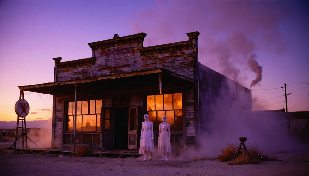
Extinct Settlements and Company Towns Along the Northern Route
Beyond the haunted ridges and spectral encounters, Highway 281’s northern stretches harbor a different kind of mystery—entire communities that vanished without fanfare.
You’ll find phantom settlements like Dobyville hidden along the route, overlooked by speeding drivers unaware they’re passing buried inhabitants.
In Denton County, Elizabethtown—dubbed Bugtown—flourished from 1850 until abandonment by 1880, leaving only a cemetery two miles from Texas Motor Speedway. Like the shadow figures reported at Cooper Creek Cemetery in Denton, these abandoned places carry an otherworldly presence that lingers long after their residents departed.
Tarrant County’s Minters Chapel represents another extinct settlement with no recorded founding date.
These highway hauntings differ from spectral hitchhikers; they’re entire communities erased from memory. The area’s history of violent conflicts between Native Americans and settlers may explain why some locations feel particularly unsettled, even decades after abandonment.
As you travel north from Archer City to Windthorst, you’re traversing through layers of forgotten history where cemeteries mark the final remnants of lost towns.
Ghost Town Types and Causes of Abandonment
You’ll encounter three primary abandonment patterns when examining ghost towns along Highway 281’s corridor.
You may also find fascinating remnants of towns that thrived during the gold rush era. Exploring ghost towns along i10 can reveal stories of hardship and resilience, showcasing the unique history of each location. With each stop, you’ll uncover artifacts and structures that paint a vivid picture of life long past.
Railroad realignments eliminated water stops and repair stations, stranding communities that depended on rail traffic for survival. Highway 281’s ghost towns represent multiple type classifications including mining, agriculture, and transportation-related settlements.
Oil boom cycles created temporary settlements that flourished during strikes but collapsed when wells ran dry or markets shifted, while occasional natural disasters forced entire populations to abandon their homes permanently. These abandoned settlements often feature scattered rubble and nature-reclaimed land where businesses and homes once thrived.
Railroad Realignment Casualties
When railroad companies made routing decisions in the late 19th and early 20th centuries, their choices to place mainlines along new corridors frequently sealed the fate of existing settlements.
You’ll find that railroad impact on communities wasn’t just about convenience—it determined survival. Companies often founded entirely new towns at chosen stations, deliberately diverting commerce and settlers away from established communities, causing systematic town decline.
The cascading effects devastated bypassed settlements through:
- Track abandonment that severed grain elevator access and competitive shipping capabilities
- Loss of county-seat functions when courthouses relocated to rail-served towns
- Economic isolation from removal of passing sidings, water towers, and station facilities
- Infrastructure deterioration including bridges, crossings, and right-of-way maintenance abandonment
These railroad realignment casualties represent communities that couldn’t adapt to corporate routing decisions prioritizing efficiency over existing settlements. Many antebellum towns west of the Mississippi River could not survive this railroad boom period, as the economic advantages shifted entirely to the new railroad-founded communities. Towns that developed around intersecting railroads around 1901 often experienced initial growth before facing eventual population decline when broader economic shifts occurred.
Oil Boom Busts
While railroad realignments gradually strangled communities over decades, oil booms created an entirely different pattern of rise and catastrophic collapse along Highway 281’s corridor.
You’ll witness dramatic oil town transformations that reshaped entire landscapes overnight. Ranger’s population exploded from hundreds to 30,000 after October 1917’s strike, while Breckenridge followed suit in 1918, swelling from 1,500 to 30,000 residents. Over 800 wells pumped frantically by 1920, creating forests of derricks across both towns.
The Panhandle boom spawned camps like Oil City, Dial, and Nadine throughout the 1920s, complete with post offices and schools.
Yet these communities couldn’t survive field depletion and highway improvements. Today, you’ll find abandoned derricks scattered across the landscape, marking where thousands once chased black gold fortunes.
Natural Disaster Abandonment
Though economic forces gradually drained many settlements, nature’s wrath struck with devastating finality that left entire communities uninhabitable within hours.
You’ll discover that environmental pressures along Highway 281 created ghost towns through sudden, catastrophic events rather than gradual decline.
Indianola exemplifies nature’s power to erase human settlement. Two hurricanes—1875 and 1886—obliterated this coastal town. Survivors made the rational choice to abandon rather than rebuild on vulnerable, low-lying ground.
Insurance companies refused coverage, recognizing the futility of defying nature’s patterns.
- Flood cycles devastated rural Texas communities when infrastructure failed
- Desert climate extremes drove residents from mercury mining towns
- Hurricane devastation left zero permanent residents in coastal areas
- Distance from resources prevented recovery after natural disasters
Environmental forces ultimately proved stronger than human determination.
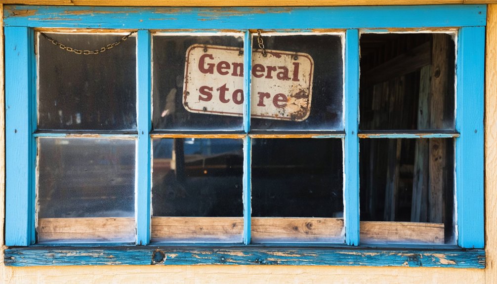
Physical Evidence and Cemetery Remains
The landscape along Highway 281 preserves tangible remnants of communities that once thrived but have since faded into obscurity.
You’ll discover crumbling foundations of service stations and diners that document mid-20th century roadside commerce between Johnson City and Blanco. Collapsed timber outbuildings mark abandoned farmsteads within 500 yards of shifted highway alignments, while weathered mileposts and original macadam fragments remain embedded in shoulders where bypasses left older routes intact.
Cemetery artifacts provide essential evidence for understanding abandonment patterns. Roofless commercial shells and boarded residences display historic architectural elements that help date community decline to the late 19th and early 20th centuries.
Former schoolhouse and church frames still stand near burial grounds, creating contextual links between surviving structures and cemetery remains that chronicle these vanished settlements.
Documented Sightings and Paranormal Phenomena
You’ll encounter numerous documented supernatural encounters along Highway 281’s most notorious stretches, where eyewitness accounts span decades of paranormal activity.
The Al Lackey hitchhiker apparition represents one of the highway’s most persistent legends, appearing between Johnson City and Blanco as a blood-stained figure carrying a foot-long knife.
These sightings connect directly to the Devil’s Backbone region, where multiple types of supernatural phenomena have been recorded by travelers, investigators, and local residents since the area’s earliest settlement periods.
Al Lackey Hitchhiker Legend
Since the 1970s, motorists traveling Highway 281 between Johnson City and Blanco have reported encounters with a towering figure who matches the same description: an exceptionally tall man with a full gray beard, red bandana around his neck, and a large bloodied knife in his hand.
These legendary sightings consistently occur during twilight hours when visibility diminishes.
Documented hitchhiker tales follow predictable patterns:
- Physical manifestation – Witnesses describe the apparition standing roadside with thumb extended, soliciting rides from passing vehicles.
- Threatening dialogue – Reports include chilling statements like “Six are still living whom I intended to kill.”
- Witness reactions – Drivers typically flee immediately upon recognizing the figure’s grotesque appearance and weaponry.
- Geographic consistency – All encounters concentrate along the Johnson City-Blanco corridor of Highway 281.
These accounts span multiple decades, transmitted primarily through oral tradition rather than official documentation.
Devil’s Backbone Apparitions
Along the serpentine stretch of road known as Devil’s Backbone, witnesses have documented a diverse array of supernatural encounters spanning multiple decades.
You’ll find Confederate soldiers thundering across ridges, their hoofbeats shaking cabin walls as twenty ghostly riders gallop through Texas Hill Country. Native American spirits, including a spectral figure named Drago, blend with the rugged landscape while herding phantom cattle along the Backbone.
The Devil’s Backbone hauntings include a woman in white searching for her lost child, crying out as she carries an infant near the tavern built on ancient Indian campgrounds.
On Purgatory Road, you might encounter ghostly apparitions materializing on car hoods, invisible hands pressing against windows, or unexplained fog rolling in.
Ghost hunters record EVP evidence while witnessing shadow people among these documented paranormal phenomena.
Research Methods and Safety Considerations for Ghost Town Exploration
Before venturing into any ghost town along Highway 281, you must establish legal access rights and assess potential hazards that could threaten your safety or result in legal complications.
Effective research strategies and safety protocols will protect you from trespassing charges, environmental dangers, and life-threatening situations in these remote locations.
Proper preparation and thorough research are your first line of defense against legal issues and potentially deadly hazards in abandoned settlements.
Your exploration planning should follow these essential steps:
- Verify land ownership through county parcel maps and obtain written permission from private landowners.
- Assess structural hazards including unstable buildings, open mine shafts, and contaminated air quality.
- Prepare emergency equipment such as respirators, first-aid supplies, and satellite communication devices.
- File detailed trip plans with emergency contacts and expected return times.
Never explore alone—use the buddy system and maintain communication redundancy for safe ghost town documentation.
Frequently Asked Questions
Are There Any Ghost Towns Completely Underwater Due to Reservoir Construction?
Yes, you’ll find several submerged towns from reservoir history including Fairdale under Toledo Bend, Proctor beneath Fontana Lake, and St. Thomas submerged by Lake Mead until drought exposed it.
What’s the Best Time of Year to Visit Ghost Towns Safely?
You’ll find late spring through early fall offers ideal seasonal weather for safe exploration. Summer’s mild temperatures keep roads accessible while avoiding winter’s snow-blocked passes and unpredictable desert conditions that threaten remote ghost town visits.
Do Any Ghost Towns Still Have Active Businesses or Residents?
Like phoenix rising from ashes, you’ll discover active businesses thriving in several ghost towns—restored museums, antique shops, and cafés operate alongside fascinating resident stories of families maintaining these historic communities against all odds.
Which Ghost Towns Require Special Permits or Guided Tours to Access?
Most ghost towns along 281 have varying access requirements depending on private ownership or federal management. You’ll need landowner permission or Special Recreation Permits for guided exploration of protected sites.
Are Metal Detectors Allowed at Ghost Town Sites Along Highway 281?
Metal detecting’s banned at 90% of ghost town sites due to metal detecting regulations and historical preservation laws. You’ll need landowner permission on private property and permits for public lands before detecting along Highway 281’s abandoned settlements.
References
- https://101highlandlakes.com/johnson-city-ghost-story-al-lackey/
- https://texashighways.com/travel/the-most-haunted-roads-in-texas/
- https://texashillcountry.com/devils-backbone-haunted-texas/
- https://texashillcountry.com/johnson-city-lackey-the-ghost-on-highway-281/
- https://www.legendsofamerica.com/tx-hutchinsonghosttowns/
- https://en.wikipedia.org/wiki/List_of_ghost_towns_in_Texas
- https://www.texasescapes.com/CFEckhardt/Ghost-on-Highway-281-Lackeys-ghost.htm
- https://www.youtube.com/watch?v=_ndTmBBAC1I
- https://texashappens.com/the-phantom-hitchhiker-of-highway-281-in-texas/
- https://www.youtube.com/watch?v=hl2iRZWdMko


