
You’ll find remarkable ghost towns scattered along Interstate 80, from California’s preserved Bodie—which housed 10,000 residents during the 1870s gold rush—to Nevada’s abandoned mining camps like Rhyolite and Tuscarora that once exceeded 20,000 people before ore depletion caused complete abandonment. Many northeastern Nevada sites sit just miles off I-80, accessible via county roads, while some locations like Midas still maintain current residents alongside historic structures. Planning your exploration reveals fascinating stories of boom-bust cycles and forgotten highway alignments.
Key Takeaways
- Most northeastern Nevada mining camps along I-80 are accessible within short drives, like Beowawe just five miles south via NV-306.
- Historic mining towns experienced dramatic boom-bust cycles, with populations reaching thousands before complete abandonment due to ore depletion.
- Remnants include decommissioned US Highway 80 segments with visible historic pavement, bridges, and early construction techniques throughout the Southwest.
- Economic displacement occurred when interstate construction bypassed original communities, leaving many towns as ghost town remnants after I-80’s 1970 completion.
- Navigation requires GPS coordinates, offline maps, and high-clearance vehicles due to unreliable cell coverage and unpaved access roads.
Sierra Nevada Canyon Settlements Lost to Progress
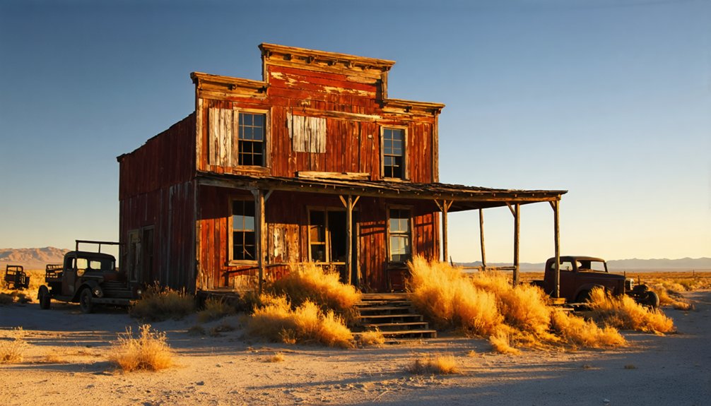
When gold and silver fever gripped the Sierra Nevada in the 1870s, Bodie emerged as the archetype of boom-and-bust mining settlements that would define the region’s volatile economic landscape.
You’ll find its population peaked near 10,000 during the gold-silver rush, generating tens of millions in economic output before inevitable decline struck.
Ore depletion, fires, and brutal winters decimated these high-elevation camps.
Bennettville’s silver dreams died at 10,000 feet elevation, while Lincoln Mine workers faced 25-foot snowdrifts and fatal exposure.
Dog Town pioneered eastern Sierra placer mining in 1857 before rapid abandonment.
Mount Ophir operated California’s first authorized mint in the early 1850s, transforming gold dust into official currency before joining the ranks of forgotten settlements.
Today’s preserved ruins represent essential cultural heritage, though mining legacies face ongoing weathering and vandalism threats. Bodie itself maintains an arrested decay state as both a National Historic Site and State Historic Park since 1962.
These ghost towns embody the Sierra’s untamed spirit.
Boca Brewery and the Truckee River Ruins
Railroad workers established Construction Camp 17 in 1866-1867 at the mouth of the Little Truckee River during the Transcontinental Railroad’s ambitious push through the Sierra Nevada.
You’ll find this spot renamed Boca in 1868, meaning “mouth” in Spanish. The Boca Brewery rose in 1876, producing California’s first lager using natural ice harvests. At its peak, the brewery churned out 30,000 barrels annually and won awards at the 1883 Paris World’s Fair.
The town flourished with Victorian hotels, stores, and saloons until the brewery burned in 1893. Modern refrigeration killed the ice trade, and by 1939, Boca’s remnants disappeared under dam construction. Engineers built an earth fill dam at this location, permanently altering the landscape. The ice industry continued operating until modern refrigeration finally forced its closure in 1927.
Boca thrived with Victorian elegance until fire and technology sealed its fate, leaving only memories beneath modern waters.
Today, you can explore broken foundations along the Truckee River where Interstate 80 crosses this once-thriving settlement.
Northeastern Nevada Mining Camps
You’ll encounter dramatic boom-bust cycles as you explore northeastern Nevada’s mining camps along I-80, where populations swung from thousands in the 1870s to complete abandonment within decades.
These camps offer varying roadside accessibility from the interstate, with some like Eureka remaining accessible towns while others require detours into remote canyons and mountain slopes.
The preservation status differs markedly across sites—from Cortez’s active modern operations as part of the world’s largest gold complex to Oriental’s scattered stone ruins where the last resident died in 1908. Some camps like Tunnel Camp north of Lovelock showcase the era’s ambitious but failed tunneling projects that attempted to drain water from old mining districts before being abandoned due to costly engineering miscalculations. The harsh realities of water shortage and extreme remoteness ultimately sealed the fate of many promising mining districts, forcing even profitable operations to cease when basic necessities became impossible to maintain.
Boom-Bust Population Cycles
Along the desolate stretches of northeastern Nevada, mining camps experienced dramatic population swells that could transform empty valleys into bustling towns of thousands within months, only to collapse just as rapidly when ore played out or commodity prices crashed.
You’ll find that these population dynamics followed predictable patterns during mining booms. Rhyolite grew to 10,000 residents in just two years, while Goldfield exceeded 20,000 between 1906-1910. Tuscarora reached over 3,000 residents during its peak years in the 1870s and 1880s.
These communities attracted transient male laborers, speculators, and immigrant groups like Chinese placer miners who comprised significant minorities.
When high-grade ore depleted or federal monetary policy shifted, populations collapsed to dozens or disappeared entirely within a decade, leaving behind the ghost towns you encounter today. The broader economic downturn contributed to Nevada’s overall population decline from 62,000 in 1880 to 47,000 by 1890.
Roadside Accessibility From Interstate
Today’s travelers can reach most northeastern Nevada mining camps within short driving distances from Interstate 80, making these ghost towns remarkably accessible compared to their remote origins.
Many camps sit within 10 miles of I-80, with some like Beowawe just five miles south via NV-306.
While well-known sites feature reliable roadside signage and paved access for standard vehicles, lesser-visited camps present navigation challenges through gravel county roads requiring high-clearance vehicles. Some locations like Midas maintain current residents alongside their historic mining structures.
These northeastern Nevada sites represent various stages of abandonment, from complete desolation to locations with a few remaining buildings still standing.
Planning considerations for ghost town exploration:
- Download offline maps – Mobile service gaps are common in remote areas off I-80
- Check seasonal conditions – Spring runoff and winter weather can make unpaved roads impassable
- Cross-reference recent trip reports – Online resources sometimes contain outdated access information
- Verify land ownership – Some sites remain on private property or restricted federal ranges
Preservation Status Varies
While Nevada’s Abandoned Mine Lands Program has secured 81.9% of documented hazardous sites statewide since 1987, northeastern Nevada’s mining camps present a mixed preservation landscape.
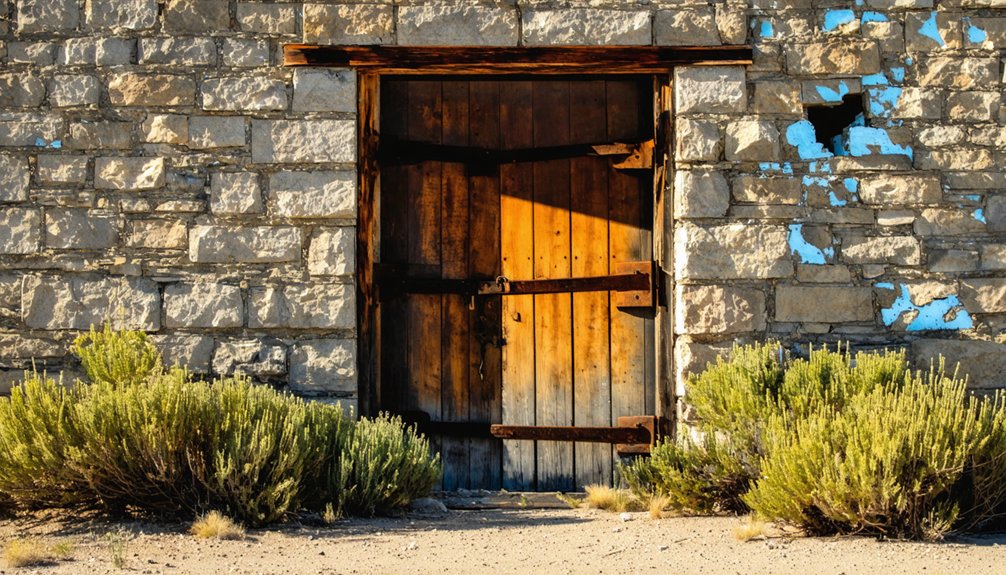
You’ll find stark contrasts between protected sites like Berlin-Ichthyosaur State Park, where authentic camp buildings and stamp mills remain frozen in time with tools positioned as workers left them, and completely abandoned locations like Aurora, where only rubble and foundations survive nature’s reclamation.
The preservation challenges you’ll encounter reflect competing priorities. Carson City achieved 96.5% site securing, while northeastern counties struggle with widespread hidden hazards near recreational areas.
Nevada’s State Historic Preservation Office emphasizes protecting mining sites’ cultural significance for future generations, yet groundwater threats and development pressures continue endangering springs and tribal areas holding millennia-old importance.
Galena and Battle Mountain Area Ghost Sites
Deep in Galena Canyon, where silver veins first sparked Nevada’s mining fever in 1863, the remnants of Galena tell a story of boom, bust, and resilience that spans more than a century.
You’ll discover scattered stone foundations and cemetery markers at 6,158 feet elevation, remnants of a town that once boasted a dozen saloons during its 1870s peak.
What You’ll Find at These Ghost Sites:
- Stone building ruins and masonry foundations surviving multiple fires
- Mid-20th-century mining equipment creating striking historical contrasts
- Cemetery markers documenting the town’s intermittent postal service periods
- Anachronistic machinery from sporadic mining operations into the 1960s
Battle Mountain history connects these sites through railroad development, while Galena mining operations declined after 1875, leaving this high-desert canyon frozen in time.
Abandoned Highway 80 Alignments and Forgotten Routes
You’ll find extensive decommissioned segments of the original US Highway 80 scattered across the American Southwest, where progressive AASHTO eliminations between 1977-1991 left behind a patchwork of abandoned alignments and redesignated routes.
These forgotten stretches include everything from the historic 1915 wooden plank road across California’s Algodones Dunes to bypassed sections in Arizona, New Mexico, and Texas that now exist as deteriorating pavement, closed bridges, and ghost-route artifacts.
The interstate system’s construction didn’t just create new roads—it systematically dismantled one of America’s first transcontinental highways, leaving behind documented remnants that tell the story of how entire communities lost their economic lifelines when traffic moved to faster, straighter routes.
Decommissioned Route Segments
As Interstate 80 carved its path across the American landscape throughout the 1960s and 1970s, it left behind a network of abandoned highway segments that tell the story of America’s most ambitious infrastructure transformation.
These decommissioned highways created forgotten landscapes where you’ll discover the remnants of America’s original cross-country route.
When state DOTs petitioned AASHTO to eliminate redundant routes, they systematically erased U.S. Highway 80 from Arizona (1977) through the Southwest during the late 1980s and 1990s.
You can still explore these ghostly corridors today:
- Desert segments in California and Arizona where old pavement crumbles beside I-8 and I-10
- Isolated ramps and stubbed connectors near major interchanges
- Abandoned bridges and culverts bypassed rather than demolished
- Former mainline stretches converted to county roads or private driveways
Historic Pavement Remnants
Beyond these decommissioned segments lie the physical remnants of the original roadway itself—fragments of concrete, brick, and even timber planks that tell the story of early highway construction techniques.
You’ll discover surviving plank-road sections from early 20th-century timber surfacing in Sand Hills stretches, where cut timber beds remain visible in dune-adjacent alignments.
Historic alignment traces reveal distinct construction methods—joint spacing, transverse grooving, and brick bonds dating to pre-1940 engineering standards.
Between Florence and Oracle Junction, rock-and-gravel patches mark changing surfacing where full paving lagged until the 1930s.
Stone Avenue’s Gothic-style underpass and Mule Pass Tunnel approaches preserve original pavement changes, while concrete mileposts and service station foundations demonstrate pavement preservation efforts documenting America’s automotive heritage.
Bypassed Town Impacts
When Interstate highways replaced the original US Highway 80 corridor during the 1960s and 1970s, entire communities that had thrived on cross-country traffic found themselves stranded along forgotten asphalt.
You’ll find stark evidence of economic displacement across multiple states where bustling highway towns transformed into crumbling foundations overnight.
The impacts created lasting urban decay patterns:
- Arizona towns lost their “Mother of Arizona Highways” lifeline when I-10 and I-8 bypassed southeastern communities by 1977.
- California’s Imperial Valley saw Holtville, Seeley, and Plaster City never recover after I-8’s completion in the 1960s.
- Wyoming locations along Lincoln Highway alignments reduced to ghost town remnants after I-80’s 1970 completion.
- Nevada’s Reno-Sparks corridor watched motels deteriorate into trailer parks following 1974 decommissioning.
Transportation Shifts That Created Modern Ghost Towns
While Interstate 80’s construction brought faster travel across the continent, it simultaneously sentenced dozens of highway communities to economic extinction.
You’ll find that transportation evolution fundamentally altered America’s travel patterns. Railroad consolidation first eliminated small-town depots and freight stops, cutting communities off from affordable long-distance connections.
Then interstate bypasses redirected traffic from older federal highways, causing immediate revenue drops for motels, cafes, and service stations that depended on through-travelers.
Vehicle technology accelerated this economic transformation. Improved fuel efficiency and reliability reduced stop frequency, while corporate travel centers concentrated business at high-volume interstate interchanges.
You can still observe abandoned bridges, garages, and railroad infrastructure documenting this rapid shift from local highway commerce to freeway-centered travel patterns.
Resource Exhaustion and Economic Collapse Along the Corridor

Although transportation changes devastated many I-80 communities, resource exhaustion delivered the most catastrophic blows to corridor settlements. You’ll find the bleakest ghost towns where natural resources simply ran out, leaving nothing for future generations.
- Mining Collapse (1920s-1950s) – Coal depletion dropped Thurmond, WV’s population from 7,000 to under 10, while Nevada’s gold mines caused 90% population loss.
- Agricultural Exhaustion (1930s-1980s) – Ogallala Aquifer depletion and Dust Bowl effects eliminated 75% of dryland farms along the corridor.
- Industrial Resource Decline (1940s-1970s) – Timber, phosphate, and salt extraction sites exhausted accessible deposits.
- Economic Boom-Bust Cycles – Casper’s oil crash triggered 40% business closures after 1970s field exhaustion.
Without proper resource management, these communities lacked economic resilience when their foundations disappeared.
Accessing Ghost Sites From Interstate 80
You’ll need proper preparation and route planning before venturing off I-80 to explore these abandoned settlements.
Most ghost town access requires traversing unpaved roads, understanding property boundaries, and carrying emergency supplies for remote areas.
Safe exploration depends on checking road conditions, informing others of your travel plans, and respecting both private property rights and public land regulations.
Planning Safe Ghost Visits
Before exploring any ghost town along Interstate 80, you’ll need to plan your route carefully since most sites require departing the main highway and traversing secondary roads of varying conditions.
Ghost town etiquette demands respect for private property and historical structures, while exploration preparedness guarantees your safety in remote locations.
Essential Planning Steps:
- Check access hours – Sites like Piedmont Kilns operate sunrise to sunset daily on Forest Service land.
- Verify road conditions – Unionville requires 35 miles on Lovelock-Unionville Road through canyon terrain.
- Respect boundaries – Point of Rocks features fenced gravesites requiring careful navigation.
- Assess structural stability – Avoid unstable ruins like those in abandoned areas, where Border Patrol monitors dangerous tunnels.
Carry emergency supplies and inform others of your planned route before departing Interstate 80.
Successful ghost town exploration requires understanding how to navigate from Interstate 80 to remote historical sites scattered across the western landscape.
You’ll find exits spaced every 20-40 miles, connecting to state highways that lead to secondary roads before dirt tracks begin. Create waypoints using GPS coordinates and offline maps since cellular coverage becomes unreliable in remote areas.
Check topographic maps for seasonal closures and private property boundaries. Effective navigation methods include logging return points and alternate routes.
Your driving precautions should emphasize high-clearance vehicles for unpaved approaches, carrying tire repair kits, and refueling at the nearest town before venturing onto dirt roads.
Verify recent conditions through local trip reports, especially after precipitation when rocky two-tracks become challenging for standard vehicles.
Legal Access Considerations
While ghost towns beckon from the roadside, legal access determines whether your exploration remains lawful or crosses into trespassing territory.
Understanding ghost town regulations prevents costly citations and protects your freedom to explore responsibly.
Federal lands surrounding I-80 ghost towns require permits for certain activities, while private property demands explicit landowner permission.
Railroad rights-of-way appear accessible but remain illegal and dangerous to enter. Access permissions vary greatly between jurisdictions, making preparation essential.
Legal Entry Routes:
- Designated pullouts – Use official interpretive parking areas and historic markers for lawful stopping
- Public roads – County roads and mapped secondary highways provide verified access when they’re public rights-of-way
- Federal trailheads – BLM and Forest Service access roads lead to settlements on public lands
- Negotiated permission – Contact landowners through county recorder offices for private townsite access
Safety Considerations and Legal Access Issues
Although exploring ghost towns along I-80 offers fascinating glimpses into America’s past, you’ll face significant safety hazards and legal restrictions that require careful planning.
In contrast, historic ghost towns along I90 present a unique opportunity for those willing to venture off the beaten path. With proper preparation, you can unearth the stories and remnants of once-thriving communities that tell tales of resilience and change. These sites not only offer a deep dive into history but also invite exploration amidst the stunning landscapes of America.
Unstable buildings pose collapse risks, while overgrown vegetation conceals dangerous holes and debris. You’ll encounter contaminated soil from industrial remnants, snakes hiding in brushy terrain, and old equipment containing sharp edges or toxic residues.
Before venturing out, secure legal permissions for private land access and respect fenced off-limits zones. Many sites have historical designation protections, and removing souvenirs violates preservation laws.
Essential safety protocols include carrying water, first-aid supplies, and flashlights while maintaining charged communication devices. Always inform others of your plans since emergency services remain limited in remote areas.
Check weather forecasts to avoid flooding conditions that spread pollutants.
Research Resources for Ghost Town Exploration
Before you venture out to explore ghost towns along I-80, extensive research through historical documents and digital resources will maximize your discoveries and guarantee you don’t miss significant sites.
Essential research tools include:
- Online mapping resources – TravelNevada.com and Roadtripryan.com provide detailed ghost town locations, while specialized guides cover regional areas from Nevada’s Unionville to New Mexico’s abandoned settlements.
- Video exploration channels – YouTube documentaries showcase forgotten Highway 80 sections and Sidetrack Adventures covers historic 1916 alignments for thorough route planning.
- Historical timeline verification – Cross-reference mining claims (Galena’s 1863 start), railroad completion dates (1902 Arrow Route), and historical transportation development periods.
- Ghost town preservation databases – Document accessibility details, current conditions, and legal entry points before departing.
These resources guarantee you’ll locate authentic sites while respecting preservation efforts.
Frequently Asked Questions
What Ghost Towns Exist Along I-80 in Utah and Wyoming?
You’ll find forgotten landmarks scattered like breadcrumbs along I-80’s route. Wyoming offers Bear River City, Piedmont, Point of Rocks, Carter, and Eadsville, while Utah features Thistle, Latuda, Iosepa, and Sego—all bearing historical significance.
Are There Camping Facilities Near Ghost Town Sites Along I-80?
You’ll find commercial campgrounds within 5-30 miles of most I-80 ghost towns, plus free BLM dispersed camping on western public lands. Check camping regulations and research best campsites beforehand since availability varies greatly.
Which Ghost Towns Have the Best Preserved Original Buildings Still Standing?
You’ll find Rhyolite’s stone bank and concrete structures showcase best preservation techniques. Atlantic City preserves forty original buildings with documented architectural features. Belmont’s courthouse and wooden houses demonstrate superior stabilization methods maintaining authentic 1800s construction details.
What Artifacts Can Legally Be Collected From Ghost Town Sites?
Steering artifact preservation is like walking a tightrope—you can legally collect items only from private property with written permission, while legal restrictions completely prohibit collecting from federal and state ghost town lands.
Do Any Ghost Towns Along I-80 Offer Guided Tours or Events?
You’ll find guided explorations at Nelson Ghost Town’s Techatticup Mine and Empire Mine State Historic Park. Both offer structured tours showcasing historical events from Nevada’s gold rush and California’s mining heritage along your I-80 journey.
References
- https://www.truckeehistory.org/ghosts-of-the-truckee-river-canyon.html
- https://www.roadtripryan.com/go/t/nevada/northern-nevada/galena-ghost-town
- https://hiddensandiego.com/things-to-do/places/abandoned-highway-80
- https://www.youtube.com/watch?v=jYfjFCHG02Y
- https://www.geotab.com/ghost-towns/
- https://www.newmexico.org/places-to-visit/ghost-towns/
- https://freepages.history.rootsweb.com/~gtusa/ontheroad/us80a.htm
- https://travelnevada.com/ghost-town/
- https://savingplaces.org/stories/explore-wild-west-mining-history-in-nevada-ghost-towns
- https://travelthruhistory.com/gold-rush-ghost-towns-and-ruins-in-californias-high-sierra/


