You’ll encounter remarkable ghost towns scattered along the Continental Divide Trail, from Atlantic City’s 37 remaining residents in Wyoming to Virginia City’s preserved 1860s boardwalks in Montana. Colorado’s high-altitude remnants include Independence at 10,900 feet and Carson at nearly 12,000 feet, both accessible only with proper 4WD vehicles and safety gear. These mining camps offer stunning wilderness views but require careful planning due to extreme elevation and weather conditions that can change rapidly without warning.
Key Takeaways
- Atlantic City, Wyoming sits in a gulch below the Continental Divide with 37 residents and offers mine tours and hiker amenities.
- Virginia City features preserved 1860s buildings and weathered boardwalks with stunning views of the Tobacco Root Mountains.
- Independence stands at 10,900 feet near Independence Pass, established after 1879 gold discovery and once housed 1,500 residents.
- Carson sits at nearly 12,000 feet on the Continental Divide, accessible only by high-clearance 4WD vehicles during summer months.
- Battle ghost town near South Pass sits at 10,000 feet elevation with mining remnants dating back to the 1890s.
Atlantic City: Where Gold Rush Dreams Meet Modern Trail Adventures
When you crest the windswept ridge near South Pass, you’ll spot the weathered buildings of Atlantic City nestled in a Wyoming gulch below the Continental Divide. This 1867 gold rush settlement once thrived with saloons, dance halls, and blacksmith shops before mines closed and residents scattered.
Today’s “Population: About 57” sign overstates the 37 souls who’ve chosen this remote outpost for privacy and personal liberty.
You’ll find unexpected trail magic here: residents serve 4 a.m. breakfasts, offer mine tours showcasing underground tunnels and mining artifacts, and provide family meals.
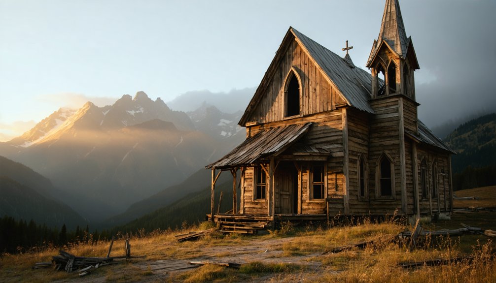
The one-room Episcopal church features Wi-Fi and key access for weary hikers.
Don’t overlook the fly-fishing opportunities or cooler resupply options before tackling your next Continental Divide Trail segment. This historic mining town sits along the path once followed by the Lewis and Clark expedition, connecting modern hikers to America’s westward expansion heritage. Be prepared for lightning and hail storms that can develop suddenly in this region, as shelter options remain limited across Wyoming’s expansive terrain.
Virginia City: Calamity Jane’s Montana Stomping Grounds
You’ll find Virginia City’s weathered boardwalks and preserved 1860s buildings create an authentic backdrop as you explore where young Martha Jane Canary once walked these muddy streets.
The town’s elevated position offers stunning views of the surrounding Tobacco Root Mountains, making it a scenic rest stop along your Continental Divide journey.
Plan your visit during daylight hours since the historic wooden walkways can become slippery and uneven in low-light conditions. When the Canary family arrived in spring 1866, Virginia City boasted a bustling 8,000 people before its dramatic decline in the following decade. Martha Jane was just fourteen years old when her family made this journey west, marking the beginning of her transformation into the legendary Calamity Jane.
Historic Boardwalks and Buildings
While modern hikers traverse the Continental Divide Trail through Montana’s rugged backcountry, a detour to Virginia City reveals remarkably preserved remnants of the 1860s gold rush that shaped this region’s history.
You’ll walk restored wooden boardwalks along Custer Avenue that once kept miners above muddy streets. The architectural significance becomes clear as you examine false-front storefronts and Italianate façades built from local timber and cast-iron elements.
Boardwalk preservation efforts maintain period-appropriate materials while meeting modern safety standards.
You’ll discover the stone Madison County Courthouse anchoring the town center, alongside historic hotels, saloons, and assay offices that served thousands during peak boom years. Virginia City served as the territorial capital despite its population declining to just 867 residents by 1870. These structures form an authentic streetscape where you can experience the urban footprint of Montana’s mining frontier. The Montana Trail connected this isolated mining region to crucial supply centers, bringing the goods and materials that sustained these bustling gold camps.
Tobacco Root Mountain Views
The dramatic silhouette of the Tobacco Root Mountains rises northwest of Virginia City, creating a stunning backdrop that reminds you why this remote corner of southwest Montana captivated fortune seekers like Calamity Jane in the 1860s.
Known locally as “the Roots,” this range stretches 26 miles between the Jefferson and Madison Rivers, offering Continental Divide Trail hikers spectacular alpine vistas from accessible viewpoints southeast of Whitehall. The mountains’ core consists of a massive Tobacco Root Batholith formed during the Late Cretaceous period, creating the dramatic igneous rock formations visible today.
The range’s mysterious name likely comes from early trappers and prospectors who discovered a tobacco substitute root in these mountains during the 1860s gold rush era. When you’re exploring this mountain ecosystem, consider these essentials:
- Elevation awareness – 43 peaks exceed 10,000 feet with Hollowtop Mountain reaching 10,604 feet
- Snow conditions – Tarns remain frozen into summer; trails accessible late September
- Wildlife encounters – Mountain goats, elk, black bears, and reported grizzlies inhabit these slopes
- Weather windows – Best hiking occurs July through September for ideal Tobacco Root views
Independence: Colorado’s High-Altitude Mining Legacy
Hikers traversing the Continental Divide Trail near Independence Pass encounter remnants of Colorado’s most ambitious high-altitude mining experiment, where prospectors established a bustling town at 10,900 feet elevation after discovering gold on July 4, 1879.
You’ll witness how extreme altitude challenged traditional mining techniques, forcing operators to adapt equipment and methods for harsh mountain conditions. The town peaked at 1,500 residents during 1881-82, supporting over 40 businesses along Main Street before shallow veins exhausted within a year.
Today’s ghost town preservation efforts maintain cabin foundations and mining structures, though you should exercise caution exploring unstable remnants. Located 16 miles east of Aspen on Highway 82, the site serves as a convenient stop for travelers exploring the region. The site carries the weight of tragedy, including a devastating dynamite explosion in 1904 that killed thirteen miners and contributed to the town’s violent labor unrest.
Preserved foundations and mining structures remain accessible to visitors, but unstable ruins require careful navigation and safety awareness.
The site’s isolation demonstrates why few high-altitude settlements survived Colorado’s boom-bust cycles. Independence’s brief but intense legacy offers trail travelers insight into prospectors’ determination to pursue wealth despite seemingly impossible environmental obstacles.
Carson: Colorado’s Sky-High Mining Camp at 12,000 Feet
You’ll need a high-clearance 4WD vehicle to reach Carson, one of Colorado’s most remote mining camps perched at nearly 12,000 feet directly on the Continental Divide.
The challenging Alpine Loop route from Lake City tests both vehicle and driver, but rewards you with remarkably preserved structures sheltered under metal roofs in the lower camp.
Plan your visit for summer through early fall only, as harsh winter conditions make this sky-high ghost town completely inaccessible.
Accessing Carson’s Remote Location
How does one reach Carson, perched precariously at nearly 12,000 feet along Colorado’s Continental Divide? Remote access demands serious preparation and rugged terrain navigation skills.
You’ll tackle Wager Gulch Road, a challenging spur off the Alpine Loop Backcountry Byway requiring high-clearance, four-wheel-drive vehicles.
Essential considerations for your Carson expedition:
- Seasonal timing – Plan visits between late spring and early fall when snowpack permits passage
- Vehicle requirements – Bring capable 4WD for rocky, rutted approaches with steep exposed sections
- Navigation tools – Pack detailed topographic maps and GPS with preloaded waypoints for unreliable cell areas
- Emergency preparedness – Carry satellite communicator or personal locator beacon for remote location safety
Respect private property boundaries while exploring this sky-high mining relic.
Historic Structures Still Standing
Two distinct mining camps emerge from Carson’s alpine landscape, each telling its own story of high-altitude perseverance.
You’ll discover the newer Carson camp, remarkably well-preserved with several empty buildings still standing in the surrounding hills. These ghostly remnants offer tangible connections to the boom years when 400-500 miners worked this mountaintop.
Old Carson sits farther up the road near the Continental Divide, where mining relics scatter across the harsh terrain.
While Carson’s now private property—viewable only from a distance—you can still appreciate the structural survivors of extreme weather and abandonment.
Both sites provide stunning vistas of the Weminuche Wilderness and Rio Grande Pyramid, rewarding your trek with spectacular alpine scenery alongside authentic mining history.
Alpine Loop Adventure Routes
While Carson’s mining remnants showcase Colorado’s high-altitude history, the 65-mile Alpine Loop connects this sky-high camp to an epic backcountry adventure through the San Juan Mountains.
You’ll tackle two major passes exceeding 12,000 feet while experiencing legitimate 4WD Adventures through terrain that’ll test your vehicle’s limits.
Essential Alpine Loop Details:
- Engineer Pass (12,800 feet) – Navigate technical switchbacks with your high-clearance 4WD
- Cinnamon Pass (12,620 feet) – Access Scenic Overlooks of Handies Peak at 14,048 feet
- Weather windows – Avoid July-August monsoons that create dangerous conditions
- Mine hazards – Stay clear of unstable shafts and collapsing structures
This historic mule-train route demands 4-6 hours, connecting Silverton, Lake City, and Ouray through Colorado’s most challenging high-country terrain.
Battle: Wyoming’s Remote Divide Settlement
Near South Pass in southwestern Wyoming, you’ll encounter the remnants of Battle, a ghost town perched dramatically on the Continental Divide itself at nearly 10,000 feet elevation.
This remote settlement’s mining history dates back to the 1890s when hundreds of residents worked the Battle Lake Mining District‘s mineral veins.
You’ll find scattered foundations, mine adits, and tailings piles where a thriving community once supported stores, hotels, and even a newspaper.
The town’s position on the topographic saddle means you’re literally walking where water splits toward Pacific and Atlantic basins.
Prepare for extreme weather conditions at this elevation—severe winters and cool summers shaped this ghost town’s seasonal rhythms.
As you explore the remnants of past lives, you might find ghost towns along the Pacific Crest Trail that tell tales of pioneer spirit and resilience. Each abandoned structure whispers stories of those who sought fortune and adventure in the rugged wilderness. Nature has begun to reclaim these sites, transforming them into hauntingly beautiful relics of history.
The high-altitude location offers stunning views but demands respect for rapidly changing mountain conditions.
Rambler: Copper Kingdom in the Clouds
As you traverse the remote Arizona desert section of the Continental Divide Trail, you’ll discover Rambler’s haunting remains scattered across the high desert landscape where copper once ruled supreme.
Originally called Signal before its 1906 transformation into Swansea, this copper kingdom represents one of the Southwest’s most ambitious mining ventures.
Rambler’s copper history spans from 1906 to 1949, producing 27 million pounds of copper through its mining legacy.
You’ll find crumbling adobe walls from the 1909 Clara Consolidated company offices and the intact dust chamber where smelter operations once thrived.
Essential exploration points:
- Two historic cemeteries marking the community’s diverse population
- Miners’ barracks near the original smelter complex
- Old railroad grade connecting to the Arizona-California line
- BLM-maintained camping sites for overnight stays
Planning Your Ghost Town Exploration Route
Planning your Continental Divide Trail ghost town exploration requires strategic thinking about logistics, safety, and access routes.
You’ll need to prioritize sites within the CDT corridor to minimize off-trail mileage and resupply complexity. Consider elevation factors—many towns like Independence and Animas Forks sit above 10,000 feet, requiring acclimatization planning.
Ghost town logistics depend heavily on seasonal access windows and vehicle capability. Summer provides the safest alpine window, while shoulder seasons bring snow-covered passes and closed dirt roads. Assess whether sites require motor access or hike-in approaches.
Hiking safety demands checking land ownership, permits, and trail conditions with local offices. Avoid unstable mine workings and respect cultural resource protections.
Prepare for rapid alpine weather changes and plan emergency egress routes for high-elevation approaches.
Essential Gear for High-Altitude Historic Sites
Ghost town exploration above 10,000 feet demands specialized gear that handles altitude exposure, unstable structures, and rapid weather changes. Your essential gear must protect against hypothermia while allowing dexterity to examine historic artifacts safely.
High altitude safety requires redundant systems since rescue isn’t readily available in remote locations. Pack lightweight but robust equipment that won’t fail when you’re investigating abandoned mines or weathered buildings.
Critical gear for Continental Divide ghost towns:
- Navigation backup – Paper maps and compass when GPS fails in mountainous terrain
- Protective equipment – Lightweight helmet for unstable structures and durable gloves for handling debris
- Altitude monitoring – Pulse oximeter to track oxygen saturation and recognize mountain sickness symptoms
- Emergency shelter – Bivy sack and extra batteries for unexpected weather delays
Preserving Mining Heritage Along America’s Backbone
The mining towns you’ll encounter along the Continental Divide don’t just tell stories—they’re disappearing at an alarming rate due to structural decay, environmental hazards, and climate impacts.
These historic mining settlements are vanishing rapidly, victims of structural deterioration, toxic contamination, and accelerating climate damage threatening their survival.
You can witness preservation efforts firsthand at places like South Pass City and Lake City, where Gateway Community programs combine heritage tourism with active restoration.
Butte’s National Historic Landmark District showcases how large-scale preservation can protect over 4,000 structures documenting mining technology evolution.
When you visit these sites, you’re supporting essential conservation work. Museums like Leadville’s National Mining Hall of Fame preserve artifacts and oral histories that might otherwise vanish.
However, contaminated soils and acid mine drainage create safety challenges that limit access to some areas, making your responsible exploration critical for ongoing preservation funding.
Frequently Asked Questions
Are Pets Allowed When Exploring These Historic Ghost Towns?
Want adventure with your furry companion? You’ll find pet friendly policies vary dramatically by land manager—National Parks restrict, while Forest Service allows more freedom. Always prioritize safety considerations given unstable structures and wildlife hazards.
What Are the Best Months to Visit High-Altitude Mining Sites?
July through August offer your best window for high altitude weather stability and seasonal accessibility. You’ll dodge snowpack issues, minimize thunderstorm exposure, and find reliable road access to remote Continental Divide mining sites.
Do Any Ghost Towns Offer Overnight Camping or Lodging Options?
Yes, you’ll find camping amenities at South Pass City’s state campground and dispersed camping near Animas Forks. Lodging availability exists in nearby towns like Aspen, though ghost towns themselves rarely offer commercial accommodations.
Are There Guided Tours Available for These Continental Divide Ghost Towns?
Yes, you’ll find guided tour options including multi-day motorbike rides, bicycle tours, and Jeep excursions that explore these sites’ historical significance. Local historical societies also offer interpretive programs, though seasonal access and advance reservations are typically required.
What Photography Restrictions Exist at These Historic Mining Locations?
Like a prospector traversing claim boundaries, you’ll face photography permits in national parks, backcountry restrictions, and historic preservation rules that ban drones, spark-producing techniques, and building entry while protecting these fragile relics.
References
- https://www.backpacker.com/videos-photos/the-best-ghost-town-hikes-in-the-u-s/
- https://www.onxmaps.com/offroad/blog/ghost-towns-off-roading
- https://www.visitouray.com/ghost-towns
- https://www.colorado.com/articles/colorado-ghost-towns
- https://www.wyomingcarboncounty.com/blog/123-5-ghost-towns-to-explore
- https://aspenhistory.org/independence-ghost-town/
- https://viajarapie.info/en/2020/03/cdt-trail-towns/
- https://cdtcoalition.org/explore-the-trail/gateway-communities/colorado/
- https://cdtcoalition.org/history-of-the-cdt/
- https://en.wikipedia.org/wiki/Continental_Divide_Trail


