You’ll encounter several ghost towns and abandoned settlements along the Pacific Crest Trail, from the eerie movie-set atmosphere of Hikertown in the Mojave Desert to the fire-scarred ruins of Belden in Northern California’s mountains. Mike’s Place at mile 12.3 features deteriorating bunkers and abandoned infrastructure, while Seiad Valley offers minimal services in a nearly forgotten community. White Pass showcases concrete remnants from failed 1960s resort development. These haunting waypoints reveal fascinating stories of decline and abandonment.
Key Takeaways
- Belden at mile 1,289 became ghost-like after the 2021 Dixie Fire destroyed multiple structures and displaced residents.
- Mike’s Place at mile 12.3 features abandoned infrastructure including a deteriorating bunkhouse and makeshift kitchen facilities.
- White Pass contains concrete ruins from a failed 1960s resort development with exposed rebar and former bunkers.
- Seiad Valley at mile 1,658 offers minimal services with limited population embodying regional independence and isolation.
- Hikertown at mile 517.6 creates an eerie movie-set atmosphere with themed cabins resembling artificial props.
Desert Wastelands: California’s Most Notorious Resupply Stops
When you commence on the Pacific Crest Trail‘s grueling 700-mile desert section through Southern California, five notorious resupply stops become lifelines in an otherwise unforgiving landscape.
Mount Laguna emerges first at mile 42, where 49% of northbound hikers tackle their initial resupply challenge. Julian’s legendary Mom’s pie draws 77% of desert travelers despite an 11-mile detour.
Warner Springs provides strategic positioning at mile 109, though many skip it after Julian’s abundance. Idyllwild stands as the desert’s crown jewel—the most beloved resupply town offering complete hiker amenities. However, reaching town requires conquering the challenging Devil’s Slide Trail, a demanding 5-mile access route that tests weary hikers.
Finally, Tehachapi commands 90.5% usage at mile 566, serving as your last salvation before the Sierra Nevada. Smart hikers embrace flexible planning since food preferences and needs change dramatically throughout the desert’s punishing terrain.
These desert challenges shape fundamental hiker experiences, transforming ordinary towns into sacred waypoints for freedom-seeking adventurers traversing California’s harshest terrain.
Hikertown: The Consistently Worst-Rated Desert Town
Despite serving as a crucial waypoint at mile 517.6, Hikertown consistently earns the Pacific Crest Trail’s most polarizing reviews among desert resupply stops.
You’ll encounter a cluster of themed cabins resembling movie-set props—complete with fake bank, sheriff’s office, and brothel facades—that create an undeniably strange atmosphere in the Mojave wilderness.
Hiker experiences range from bemused tolerance to outright disappointment, with many describing the accommodations as primitive and uncomfortable.
The quirky aesthetics appeal to some adventurers seeking novelty, while others find the makeshift “town” simply bizarre. Highway noise and sparse amenities compound the mixed reception.
Yet you’ll likely stop here anyway.
Positioned before the water-scarce LA Aqueduct crossing, Hikertown provides essential resupply services and reliable water access that outweigh its consistently poor ratings among thru-hikers. The affordable fees make basic services accessible, with just a $10 charge for general amenities and reasonable rates for showers and overnight stays. You can arrange to have resupply boxes shipped directly to Hikertown with your name and expected arrival date, making it a convenient logistical hub despite its other shortcomings.
Acton KOA: Years of Hiker Disappointment
You’ll find Acton KOA consistently appears in PCT hiker forums as a disappointing resupply stop, with complaints spanning multiple hiking seasons from 2018 through 2024.
The campground’s desert location near Highway 14 creates a perfect storm of overcrowding during peak thru-hiker season, unreliable Wi-Fi for resupply coordination, and deteriorating facilities that haven’t kept pace with increased PCT traffic.
What started as a convenient trail town alternative has transformed into a cautionary tale documented across countless trip reports and social media posts. Some hikers have reported threatening encounters with questionable “trail angels” at the facility, adding safety concerns to an already problematic stop.
Many hikers now prefer alternative stops like Hiker Heaven, which offers genuine trail angel hospitality with proper facilities and volunteer support for essential services like laundry and gear repair.
Desert Resupply Failures
If you’ve spent time reading PCT resupply guides from the past decade, you’ll notice Acton KOA appearing repeatedly in the “problematic desert stops” category alongside notorious locations like Hikertown.
Your hiker experiences at this waypoint consistently include package handling fees, limited amenities despite marketing claims, and noise from adjacent roads and train tracks that disrupts recovery time.
These operational failures force you to modify your resupply strategies. Instead of relying on Acton’s small store, you’ll need to hitch to Agua Dulce or Tehachapi for complete grocery runs. The desert towns serve as the first exposure for northbound hikers on the PCT, making these early negative experiences particularly impactful.
The 2024 data shows only 23.4% of hikers actually use Acton KOA, with most bypassing it entirely. Inconsistent post office hours and staff knowledge create package pickup delays that can extend your desert stretches beyond planned distances. Many experienced hikers recommend using General Delivery at more reliable post offices in established trail towns to avoid these complications.
Multi-Year Ranking Decline
When examining hiker feedback patterns from 2017 through 2024, Acton KOA’s reputation has declined steadily across multiple trail seasons.
You’ll notice consistent complaints about campground issues that’ve driven away independent-minded hikers seeking reliable resupply points.
The deteriorating hiker feedback reveals these recurring problems:
- Unusable internet service – Critical for trail planning and communication with loved ones back home
- Overcrowded tent spaces – Huge tents crammed into every available corner without consideration for privacy
- Overpriced cabin rentals – Management prefers keeping cabins empty rather than offering reasonable rates
- Threatening behavior from staff – 2024 reports include trail angel threats that contradict hospitality expectations
Each year brings fresh warnings from previous hikers, creating a vortex effect where you’re pulled in by necessity but pushed toward quick departures. Most hikers complete their essential tasks like showering and laundry services before heading into town for better dining options. Many experienced thru-hikers choose to bypass the KOA entirely, continuing an additional 6.6 miles to find more peaceful camping spots along the trail.
Proximity Location Challenges
Although Acton KOA sits conveniently at PCT mile 444 with easy paved access, its location creates a perfect storm of logistical problems that compound the campground’s existing issues.
You’ll face inconsistent shuttle availability, forcing reliance on unpredictable trail angels or expensive taxis for resupply runs. The proximity to busy CA-14 highway crossings demands careful timing adjustments, while limited maildrop options in nearby small towns force you into longer-distance planning or overpriced KOA store purchases.
Access challenges intensify during peak season when trailhead congestion complicates gear staging and vehicle support coordination.
Heat exposure on approaches requires early-morning departures, yet overcrowded facilities disrupt sleep quality needed for safe travel.
These location-specific problems transform what should be a straightforward resupply stop into a costly detour that degrades hiker experiences through timing pressures and logistical friction.
Belden: Fire-Scarred and Half-Abandoned in Northern California
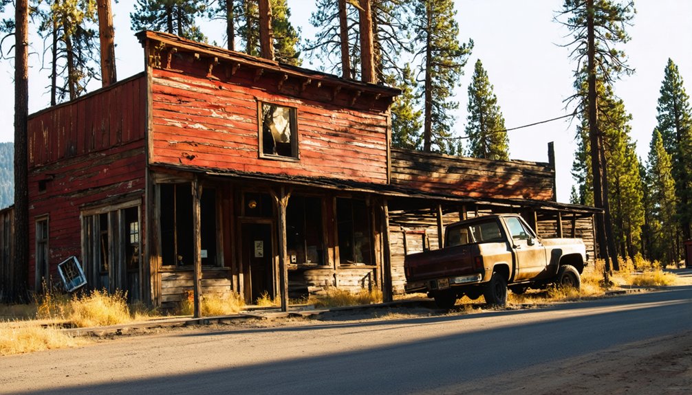
You’ll encounter Belden around PCT mile 1,289, where the 2021 Dixie Fire transformed this former railroad logging town into a haunting landscape of charred slopes and skeletal trees.
The fire destroyed several buildings while sparing others in seemingly random patterns, leaving survivors scattered among ash-covered lots where neighboring structures once stood.
What remains is a settlement with only a handful of permanent residents, creating an eerie atmosphere where the few intact buildings feel isolated against the backdrop of Northern California’s fire-scarred canyon walls.
Dixie Fire Aftermath
Since the Dixie Fire swept through Northern California’s Feather River canyon in 2021, Belden has transformed from a small mountain community into a fire-scarred settlement teetering between abandonment and stubborn persistence.
The fire impact devastated over 1,200 structures statewide, leaving this remote hamlet partially gutted and struggling with Belden recovery efforts.
You’ll witness the aftermath through these stark realities:
- Widespread destruction – Multiple residences and outbuildings burned, creating a patchwork of ruins
- Infrastructure collapse – Highway 70 closures and utility damage severed essential supply lines
- Population displacement – Extended rebuilding timelines forced long-term vacancy of properties
- Ecological transformation – Nearly one million burned acres altered watershed function and slope stability
Insurance limitations, terrain challenges, and phased hazard mitigation requirements have slowed reconstruction, leaving Belden caught between its past and an uncertain future.
Eerie Abandoned Atmosphere
When you approach Belden from Highway 70, the town’s eerie atmosphere strikes you immediately through a haunting collection of vacant buildings, charred timber, and scattered debris fields that create one of the Pacific Crest Trail’s most unsettling resupply stops.
You’ll walk past gutted structures with intact facades but hollow interiors, their empty windows watching like dead eyes. The surrounding slopes display blackened snags from wildfire damage, amplifying the abandonment you feel throughout this former logging community.
Weathered roadside signs and collapsed outbuildings dot the compact streetscape, while occasional residents peer from behind blinds in the few occupied homes.
These haunting landscapes consistently earn Belden rankings among hikers’ least-favored PCT towns, though trail angels still provide essential services to weary thru-hikers passing through this atmospheric ghost town.
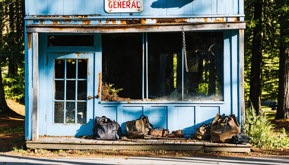
Mike’s Place: Remnants of a Once-Thriving Trail Community
At mile 12.3 of the Pacific Crest Trail’s early southern section, a steep access road leads you away from the main trail to what remains of Mike’s Place, a once-bustling trail angel destination that served hikers for decades before declining into its current ghost town status.
This desert oasis still evokes powerful hiker nostalgia through its remnants of community spirit:
- Water cache system – Large cylinders marked “must be filtered” provide essential hydration in this dry terrain.
- Abandoned infrastructure – Deteriorating bunkhouse, makeshift kitchen, and hiker-built toilet facilities tell stories of past gatherings.
- Cultural artifacts – Art murals, wall signatures, and decade-old hiker notebooks preserve memories from the site’s 2016 heyday.
- Ghost town atmosphere – Half-completed projects and piles of junk create an eerie contrast to Warner Springs ahead.
Seiad Valley: Northern California’s Forgotten Resupply Challenge
While most Pacific Crest Trail resupply towns have evolved to embrace the hiking economy, Seiad Valley remains stubbornly frozen in time at mile 1,658, where the trail drops to 1,371 feet along California’s Klamath River.
You’ll find limited services at the single store housing the post office, offering basic groceries and hiker boxes—but don’t expect extensive resupply options.
The real challenge begins when you leave town.
You’ll face an immediate 3,500-foot climb over eight grueling miles, starting with a tedious roadwalk across Grider Road’s Klamath River bridge.
Four steel-and-wood crossings over Grider Creek await as you ascend toward Cook and Green Pass.
This State of Jefferson community embodies regional independence—remote, self-reliant, and indifferent to modern trail commerce.
Seiad Valley’s resupply challenges test your planning skills and commitment to genuine wilderness experience.
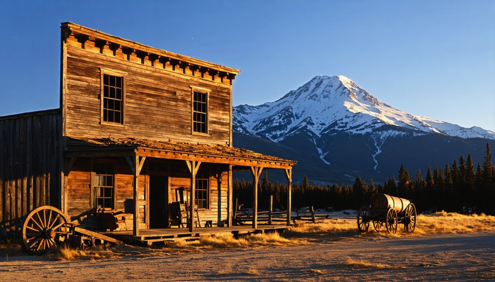
White Pass: Washington’s Concrete Ghost Town
Moving north from California’s rugged independence into Washington’s Cascade Range, you’ll encounter a different kind of trail mystery at mile 2,300.
White Pass conceals concrete structures from a failed 1960s resort development, creating Washington’s most accessible ghost town along the PCT.
These weathered ruins hold historical significance as remnants of ambitious expansion plans that never materialized. The concrete structures include foundations, walls, and building pads now reclaimed by wilderness.
What you’ll discover at White Pass:
- Exposed rebar walls covered in decades of graffiti and forest overgrowth
- Former U.S. Forest Service bunkers used for storage and temporary worker housing
- Easy access via short scramble from Highway 12 or PCT crossing
- Stable viewing from outside, though interior exploration remains off-limits for safety
The site spans less than one acre at 4,500 feet elevation.
Frequently Asked Questions
Are There Any Safety Concerns When Staying Overnight in These Abandoned PCT Towns?
You’re playing with fire staying overnight in abandoned PCT towns. Wildlife encounters increase near structures, abandoned buildings pose collapse risks, trespass laws carry penalties, and emergency services remain limited in remote locations.
Which Ghost Towns Still Have Functioning Post Offices for Mail Drops?
You’ll find functioning post offices for mail drop logistics in Independence, Sierra City, Stehekin, and Warner Springs—these towns blend ghost town history with active postal services, accepting General Delivery for PCT resupply needs.
What’s the Average Cost Difference Between Ghost Town Resupplies and Normal Towns?
You’ll pay through the nose with ghost town resupplies averaging $20-30 more than normal towns. Smart resupply strategies and thorough cost analysis show bulk buying in regular towns saves roughly $100 per ten packages versus premium trail locations.
Exploring the region can be rewarding, especially if you’re interested in historic sites near Las Vegas. Many visitors overlook the fascinating stories and unique architecture found in these locations, which provide a glimpse into the past. Taking time to visit these sites can enhance your understanding of the area’s rich history and culture, making your trip even more memorable.
Do Any of These Towns Offer Emergency Services or Medical Facilities?
No, you won’t find staffed emergency services in PCT ghost towns. You’ll need emergency contacts via satellite devices since cellular coverage fails. Medical access requires traveling 30-120+ minutes to active towns with hospitals.
How Far Off-Trail Do Hikers Need to Detour to Reach These Resupply Points?
You’ll detour immediate spurs under 0.5 miles, moderate trails 0.5-3 miles, significant road access 3-15 miles. Off trail distances vary dramatically; navigation challenges increase with remoteness from established PCT corridors and marked access points.
References
- https://www.halfwayanywhere.com/trails/pacific-crest-trail/worst-pacific-crest-trail-resupply-towns/
- https://musthikemusteat.com/beyond-the-pnw/paria-pahreah-ghost-town-cemetery/
- https://thetrek.co/pacific-crest-trail/almost-every-pct-town-ranked/
- https://californiahighsierra.com/trips/explore-ghost-towns-of-the-high-sierra/
- https://thetrek.co/mikes-place-ghost-town-or-community-relic/
- https://www.pcta.org/discover-the-trail/thru-hiking-long-distance-hiking/resupply/pct-resupply-towns-locations/
- https://www.whiteblaze.net/forum/archive/index.php/t-62246.html
- https://www.backhackerbabe.com/pacific-crest-trail/pctresupplyguide
- https://www.halfwayanywhere.com/trails/pacific-crest-trail/pct-resupply-guide-2024/
- https://www.talesofatrail.com/pct/pct-resupply-guide


