
You’ll find numerous ghost towns scattered along the historic Santa Fe Trail, from Kansas prairie settlements like Diamond Springs and Parkerville to Colorado’s abandoned trading posts near Bent’s Fort. These communities once served thousands of wagon caravans between 1821-1880, providing essential services like wagon repairs, provisions, and lodging. Railroad development, Civil War raids, and changing trade routes eventually led to their abandonment, leaving behind weathered adobe walls, stone foundations, and archaeological remnants that reveal fascinating stories of America’s westward expansion.
Key Takeaways
- Diamond Springs and Parkerville in Kansas became ghost towns after railroads bypassed these former wagon repair and provision stops.
- Black Jack Crossing’s prosperity ended permanently following Quantrill’s devastating 1863 Civil War raid on the community.
- Colorado’s Mountain Branch contains abandoned trading posts like Bent’s Fort and the former water stop of Timpas.
- Military outposts including Fort Union became archaeological ruins after railroads eliminated the need for wagon train protection.
- Oklahoma’s Cimarron Valley preserves authentic trail evidence with remnants like Autograph Rock inscriptions from travelers.
The Historic Santa Fe Trail and Its Forgotten Communities
When William Becknell launched the first major trading expedition from Franklin, Missouri, to Santa Fe in 1821, he unknowingly set in motion the creation of dozens of frontier communities that would flourish for half a century before vanishing into historical obscurity.
You’ll find that trail traffic exploded from hundreds of caravans annually in the 1820s to thousands by the late 1840s. This surge created demand for strategically positioned settlements offering wagon repair services, provisions, and lodging at vital stops along the 900-mile route. The increased activity disrupted bison herds’ grazing patterns and contributed to overhunting that would eventually diminish the power of the Comanche who controlled much of the surrounding territory.
These communities sprouted wherever geography demanded—at river crossings, reliable springs, and natural chokepoints where caravans couldn’t avoid stopping. The treacherous Arkansas River crossings alone generated multiple settlements where merchants gathered to coordinate dangerous fording operations.
Geography dictated where frontier towns emerged—at crucial river crossings, dependable water sources, and unavoidable bottlenecks along the trail.
Each town served the essential function of keeping commerce flowing westward, providing blacksmiths, traders, and innkeepers who sustained America’s most important commercial lifeline to Mexican markets.
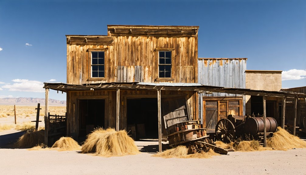
Kansas Prairie Ghost Towns and Abandoned Settlements
Four distinct Kansas settlements along the Santa Fe Trail corridor demonstrate how geography, economics, and historical events shaped the rise and fall of prairie communities.
These ghost towns reveal significant settlement patterns that defined 19th-century westward expansion.
Diamond Springs served as a vital watering stop from the 1820s, hosting hotels and trading posts before railroad bypasses triggered its abandonment.
You’ll find only spring locations and stone foundations remain today.
Parkerville represents railroad-era development, surviving as a semi-ghost town with 45 residents. The town was originally established in 1870 by Charles G. Parker along the Neosho River after the Missouri-Kansas-Texas Railroad reached the area.
Black Jack Crossing’s 1850s prosperity ended abruptly when Quantrill’s 1863 raid devastated the community.
Pawnee County experienced similar boom and bust cycles, with populations rapidly growing from 170 residents in 1870 to over 5,000 by 1880.
Key characteristics include:
- Natural resources determining initial settlement locations
- Railroad routing decisions affecting long-term viability
- Civil War violence accelerating community decline
- Cultural heritage preservation through cemetery markers
- Trail ruts serving as archaeological evidence
Oklahoma and Colorado Mountain Route Remnants
You’ll find Oklahoma’s Cimarron Valley preserves some of the most authentic Santa Fe Trail evidence, including carved inscriptions at Autograph Rock and stone remnants at Cold Spring camps that document traveler experiences along this challenging route.
Colorado’s Mountain Branch reveals a different story through abandoned trading posts like Bent’s Fort and Boggsville, where commercial networks shaped settlement patterns before railroad competition triggered rapid decline. Towns like Timpas once thrived as water stop locations with populations reaching 120 residents, complete with restaurants, hotels, and dance halls serving trail travelers. These settlements faced constant threats from stampeding bison herds that complicated daily operations and forced residents to develop protective measures.
At Raton Pass, you can still trace archaeological scatters of dismantled wagons and examine structural ruins that mark where steep grades forced travelers to stop, repair, and sometimes abandon their equipment entirely.
Oklahoma Route Historic Landmarks
Several significant landmarks along the Oklahoma portion of the Santa Fe Trail’s Cimarron Cutoff reveal the harsh realities travelers faced while crossing this unforgiving terrain.
Wolf Mountain served as a vital navigation point nine miles north of Boise City, where trail branches split around the landmark before converging at Upper Flag Spring‘s reliable water source. Artifacts discovered at this location included burned wagon parts and iron-rimmed wheels, evidence of the Indian attacks that made this route so perilous.
These sites tell stories of survival and determination:
- Autograph Rock – Thousands of names carved into sandstone cliffs from 1820s-1865, marking one of the trail’s most dangerous campsites
- McNees Crossing – Well-preserved crossing point that appears much like trail days
- Inscription Rock – Smaller site featuring a stone stage station and unmarked graves
- Trujillo Springs – Now-dry watering hole near David Trujillo’s homestead ruins
- Upper Flag Spring – Departure point from Cimarron River watercourse, scene of Indian troubles
Northeast of Boise City, travelers once navigated Willow Bar Crossing, identifiable by its distinctive sandbar covered with willow trees that marked the safe passage through the riverbed.
Colorado Mountain Trading Posts
While Oklahoma’s Cimarron Cutoff challenged travelers with its waterless stretches and dangerous terrain, the Mountain Branch of the Santa Fe Trail offered a different path through Colorado that centered around massive trading operations.
You’ll find that Bent’s Old Fort dominated this trading post history from 1833 to 1849, serving as America’s premier southwestern commercial hub. This adobe fortress facilitated mountain commerce worth millions, handling everything from firearms and cloth westbound to buffalo hides and silver eastbound.
You’d have witnessed trade values exploding from $65,000 to $40 million as merchants chose freedom over government control. The challenging terrain meant oxen teams could only cover 10-20 miles per day while hauling precious cargo across the rugged landscape. During the U.S. War with Mexico, the fort served as a military supply depot though the government never compensated the owners for its use. When William Bent torched his empire in 1849, he’d already established the blueprint for independent frontier commerce that defined Colorado’s territorial expansion.
Raton Pass Trail Evidence
When William Becknell first recorded his journey over Raton Pass in September 1821, he established what would become the most strategically important mountain gateway along the Santa Fe Trail‘s northern route.
You’ll find compelling trail evidence throughout this rugged corridor that demonstrates its historical significance as America’s first major commercial lifeline to the Southwest.
Physical remnants reveal the pass’s evolution from primitive trading route to engineered thoroughfare:
- Richens Wootton’s toll road foundations with original culverts and bridge abutments
- Wagon rut impressions carved into volcanic mesa surfaces
- 1866 grading cuts blasted through treacherous mountain sections
- Military staging areas where General Kearny’s troops camped during 1846 conquest
- Railroad grade markers from the 1878 Atchison, Topeka, Santa Fe construction
These artifacts chronicle how determined pioneers transformed an impassable wilderness into civilization’s pathway west.
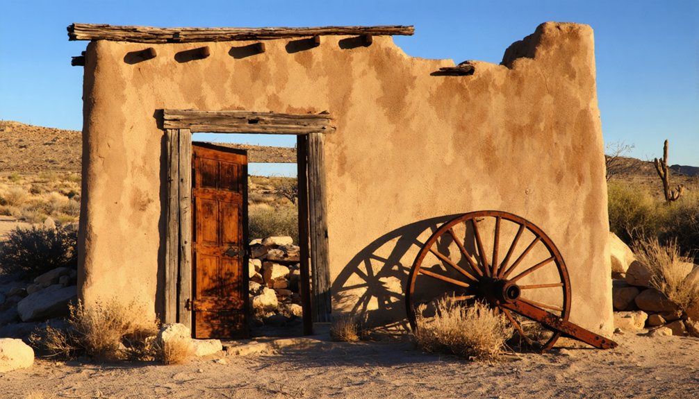
New Mexico’s Mining Boom Towns and Their Decline
Long before Spanish conquistadors arrived in search of precious metals, Native Americans had already established sophisticated mining operations in New Mexico’s Cerrillos Hills, extracting turquoise between A.D. 700 and 900 for extensive trade networks spanning the Southwest and Mesoamerica.
Native Americans operated sophisticated turquoise mines in New Mexico’s Cerrillos Hills centuries before Spanish conquistadors arrived seeking precious metals.
You’ll discover Cerrillos History began transforming dramatically when the Atchison, Topeka and Santa Fe railroad arrived in 1880, sparking explosive growth.
Mining Techniques evolved from simple extraction to industrial-scale operations producing turquoise valued at $1,600,000 by 1889. The town boasted over twenty saloons, hotels, and newspapers.
However, you’ll find these boom towns couldn’t survive technological shifts. Diesel fuel replaced coal, natural gas offered cleaner heating alternatives, and train stations closed by 1940, leaving ghost towns scattered along today’s Turquoise Trail Byway.
Military Outposts That Became Ghost Sites
You’ll find that military outposts along the Santa Fe Trail often shared the same fate as mining towns—abandonment once their strategic purpose ended.
Fort Union transformed from the largest military depot in the Southwest to archaeological ruins after the railroad eliminated the need for wagon train protection in 1879.
Sites like Kit Carson’s Camp Nichols and numerous temporary cantonments now exist only as earthworks and foundations, their wooden structures long since collapsed or salvaged by settlers.
Abandoned Fort Structures
While the Santa Fe Trail‘s commercial heyday has long passed, the abandoned military fortifications that once protected its essential trade routes stand as haunting reminders of America’s westward expansion.
You’ll find these fortress ruins scattered across the plains, each telling stories of strategic defense and eventual obsolescence.
Fort Union evolved through three construction phases before railroad expansion rendered it unnecessary.
Fort Larned’s well-preserved structures demonstrate exceptional frontier architecture integrity.
These installations share common abandonment patterns:
- Railroad development eliminated trail-dependent commerce
- Reduced Native American conflicts decreased military necessity
- Budget constraints forced post consolidations
- Harsh prairie conditions accelerated structural deterioration
- Remote locations complicated maintenance logistics
Today, you can explore these ghost fortifications through national monuments and historic sites, witnessing firsthand how military infrastructure adapted to frontier challenges before succumbing to technological progress.
Kit Carson’s Camp Nichols
Though established for only four months in 1865, Kit Carson’s Camp Nichols represents one of the most strategically positioned yet ephemeral military installations along the Santa Fe Trail.
You’ll find this 200-by-200-foot stockaded fort was Carson’s answer to increasing Plains Indian raids threatening wagon trains on the dangerous Cimarron Cutoff. Trail Protection required a midpoint garrison between Fort Union and the Arkansas River crossing, exactly what Camp Nichols provided with its 300-soldier garrison of New Mexico and California volunteers.
Despite its brief existence from May to September 1865, the camp served as the only human-made shelter along the active Cimarron route.
Today, you’ll discover only scattered stone ruins on private land, evidence of this forgotten outpost that once safeguarded America’s western commerce.
Preserving the Legacy of Trail Town Ruins
As weathered adobe walls and crumbling stone foundations face inevitable decay along the Santa Fe Trail corridor, preserving these fragile remnants requires an all-inclusive approach that balances historical documentation, legal protection, and hands-on conservation.
You’ll find that effective preservation combines cutting-edge technology with grassroots stewardship.
Archaeological surveys reveal underlying Puebloan and Hispanic-era layers, while community engagement builds essential volunteer monitoring networks.
Beneath weathered trail surfaces, ancient civilizations emerge through careful excavation while dedicated volunteers safeguard these discoveries for posterity.
Key preservation strategies include:
- High-resolution 3D photogrammetry documenting current conditions and wagon-track alignments
- Conservation easements securing long-term protection on privately owned trail properties
- Historically appropriate stabilization using lime plasters and compatible adobe materials
- Minimal-impact visitor infrastructure preventing trampling of fragile features
- Standardized condition assessments enabling comparative monitoring across multiple sites
This extensive framework guarantees future generations can experience these irreplaceable historical landscapes.
Frequently Asked Questions
What Safety Precautions Should Visitors Take When Exploring Ghost Towns Today?
You’ll need reliable maps, recovery gear, and first aid supplies while avoiding structural hazards like unstable buildings and mine shafts. Stay alert for wildlife encounters, respect private property, and travel with companions during daylight hours only.
Are Any Ghost Town Buildings Safe to Enter or Explore Inside?
You can safely enter restored buildings like Lake Valley’s schoolhouse museum and Pinos Altos’ maintained structures. However, most abandoned structures remain off-limits due to historical preservation requirements and safety hazards.
Can Artifacts or Relics Be Legally Collected From Abandoned Trail Sites?
No, you can’t legally collect artifacts from most abandoned Santa Fe Trail sites. Despite theories about “finders keepers,” strict legal regulations and artifact preservation laws prohibit removal from federal, state, and many private lands without permits.
Which Ghost Towns Offer Guided Tours or Visitor Facilities Year-Round?
You’ll find limited year-round guided explorations at Santa Fe Trail ghost towns. Most sites lack permanent visitor amenities or structured tours, requiring self-guided exploration. Seasonal access varies by location and weather conditions affecting remote areas.
When it comes to exploring abandoned towns in California, adventurers can uncover a rich tapestry of history and haunting beauty. Each deserted street and decaying building tells a story of a once-vibrant community, now at the mercy of time and nature. It’s an intriguing glimpse into the past, perfect for those yearning to connect with the forgotten chapters of the Golden State.
How Do Weather Conditions Affect Access to Remote Ghost Town Locations?
Remote locations lack cell coverage 80% of the time, amplifying weather impact on your safety. You’ll face seasonal access restrictions from snow, flooding, and impassable mud conditions that close unpaved routes for weeks.
References
- https://www.legendsofamerica.com/we-santafetrailroutes/
- https://www.travelks.com/blog/stories/post/one-epic-trail-two-hundred-years/
- https://santafe.com/new-mexico-road-trip-ghost-towns/
- https://www.newmexico.org/places-to-visit/ghost-towns/
- https://www.youtube.com/watch?v=qydxOXJFfqU
- https://www.nps.gov/safe/learn/historyculture/map-timeline-4.htm
- https://npshistory.com/publications/safe/index.htm
- https://en.wikipedia.org/wiki/Santa_Fe_Trail
- https://newprairiepress.org/cgi/viewcontent.cgi?article=1317&context=sfh
- https://santafetrail.org/timeline-of-the-santa-fe-trail/


