You’ll find seven ghost towns within a three-hour radius of Las Vegas, including Goodsprings with its 1913 Pioneer Saloon and Nevada’s oldest underground operation at Potosi Mine. Eldorado Canyon’s Techatticup Mine, discovered in 1861, generated $10 million before closing in 1941. Rhyolite’s population surged to 10,000 after the 1904 gold strike, leaving ruins like the Cook Bank building. These sites form natural exploration loops along US-95 and US-93, with specific gear requirements and seasonal considerations that’ll maximize your experience.
Key Takeaways
- Goodsprings features Nevada’s oldest underground Potosi Mine from 1856 and the historic 1913 Pioneer Saloon between Vegas and Grand Canyon.
- Eldorado Canyon’s Techatticup Mine, discovered in 1861, produced $10 million in gold with original equipment and tunnels still explorable.
- Rhyolite boomed after 1904 gold discovery, reaching 5,000 residents before declining by 1911, leaving notable ruins like Cook Bank building.
- Thompson operated from 1910-1928 as a copper mining town with a smelter processing 700-1000 tons daily, now showing scattered remnants.
- Seven ghost towns form exploration loops along US-95 and US-93, best visited spring or fall with high-clearance vehicles recommended.
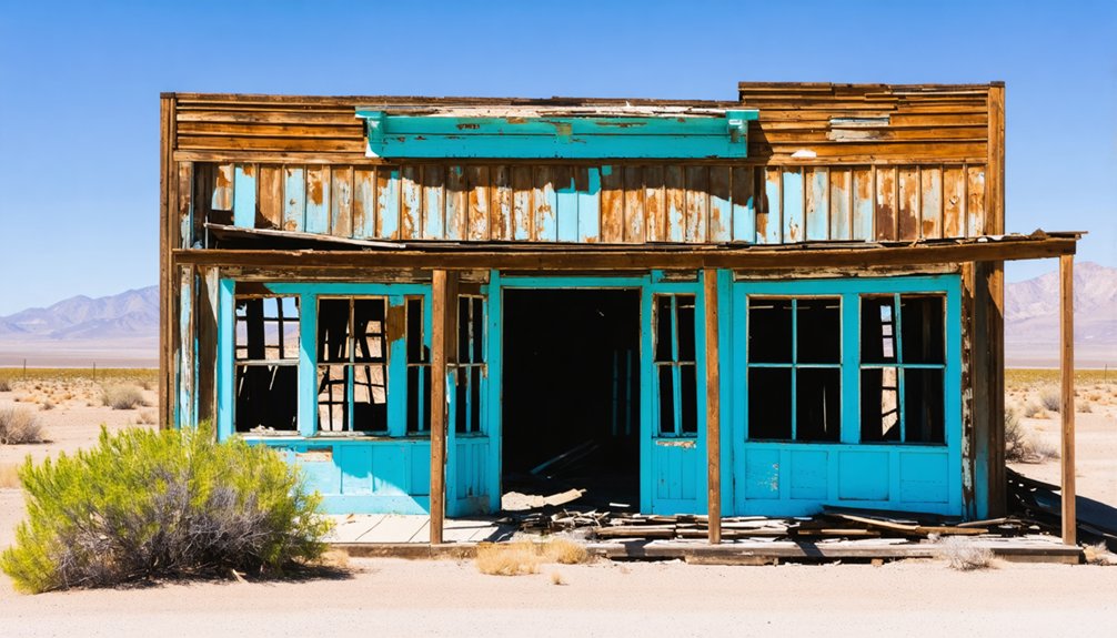
Goodsprings: A Living Relic of Nevada’s Mining Past
Between the bright lights of Las Vegas and the vast expanse of the Grand Canyon lies Goodsprings, a settlement where Nevada’s mining heritage remains etched into every weathered building and abandoned shaft.
You’ll find Nevada’s oldest underground operation here—Potosi Mine, where Mormons extracted ore in 1856. The town’s significance emerged when prospectors discovered gold in 1882, establishing the Yellow Pine Mining District.
By 1916, 800 residents worked mines that yielded the state’s greatest mineral variety: gold, silver, copper, zinc, and even platinum. Mining techniques evolved rapidly as companies consolidated operations, building concentrators and narrow-gauge railroads. The Yellow Pine Mining Company constructed a large smelter near Goodsprings by 1910, transforming raw ore into valuable metal products.
Historical artifacts pepper the landscape—the 1913 Pioneer Saloon still stands, while abandoned headframes mark where $31 million in ore once flowed from Clark County’s most productive district. The settlement was named after cattleman Joseph Good, reflecting its dual origins as both a mining and ranching community.
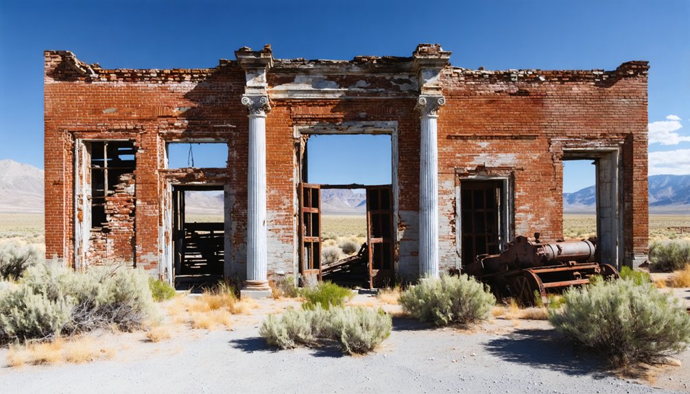
Techatticup Mine in Eldorado Canyon: Where Spanish Gold Seekers Left Their Mark
You’ll discover Spanish explorers may have struck precious metals here as early as 1775, centuries before the 1861 Techatticup discovery that launched systematic extraction.
When Civil War tensions gripped the nation, prospectors found refuge in this remote Nevada canyon, establishing what became the region’s most productive gold operation—yielding over $5 million from a single mine by the 1940s.
Today, you can walk the same tunnels that 19th-century miners carved 380 feet into the earth, examining original equipment where desperate men once resolved disputes with gunfire, 200 miles from the nearest law. The camp’s isolation attracted 300-500 miners during the early 1860s, prompting military troops to arrive in Spring 1863 for protection. In 1994, restoration efforts began transforming these abandoned mine grounds into a popular destination combining historical tours with photography opportunities for visitors exploring Nevada’s rugged mining heritage.
Spanish Mining Heritage 1700s
Long before American prospectors flooded into Eldorado Canyon, Spanish explorers from Mexico traced the Colorado River’s banks in search of precious metals that would justify the arduous journey north.
You’ll find the roots of Spanish mining in this region dating to 1775, when expeditions guided by Indian allies discovered gold deposits. They christened the area “Eldorado,” though initial silver findings along the riverbanks disappointed them.
The Spaniards deemed the yields insufficient and abandoned their efforts, never realizing richer gold veins lay deeper within the canyon walls.
This historical legacy of early Spanish exploration established southern Nevada’s mining potential nearly a century before Johnny Moss’s 1861 strike launched the American rush.
The remoteness and perceived low productivity that deterred eighteenth-century fortune-seekers ultimately preserved untold wealth for future prospectors. The gold rush of 1861 transformed the canyon into a bustling mining district after the significant strike that original miners had attempted to keep secret.
When the Techatticup Mine opened in 1863, it would become the principal mine in the area, validating what the Spanish had left behind.
Civil War Desert Refuge
While Spanish prospectors abandoned Eldorado Canyon’s perceived meager deposits in the 1770s, Johnny Moss’s 1861 gold strike on the Salvage Vein transformed this remote desert gorge into Nevada’s most violent mining district.
You’ll find that Civil War deserters fled here seeking anonymity in a place where law enforcement refused to enter. The canyon’s isolation attracted outlaws who exploited mining claim disputes as cover, creating lawless violence that surpassed even Tombstone’s notorious reputation during the 1860s.
The Techatticup Mine, whose name derives from Paiute words meaning “hungry” or “bread,” became the canyon’s most productive operation, yielding millions of dollars in gold ore transported by steamboats along the Colorado River. The mine continued operations until 1941, ultimately generating $10 million in total revenue.
Modern Historical Mining Tours
Standing at the Techatticup Mine entrance today, you’re positioned at the exact site where Spanish expeditionaries in 1775 abandoned what would become Nevada’s richest southern gold deposit.
You’ll descend through a dozen tunnel tiers carved 500 feet beneath the canyon, where constant 70-degree temperatures preserved the shafts exactly as miners left them.
Historical mining artifacts line the passages—rusted blasting powder canisters, cyanide treatment equipment, and original ore carts that hauled $10 million in gold between the 1860s and 1900.
Tours reveal how modern mining techniques evolved from simple 1850s stream sluicing to sophisticated tunnel-blasting operations.
The Southwest Mining Company’s infrastructure remains intact, documenting an era when steamboats delivered supplies upriver and lawlessness reigned 200 miles from the nearest sheriff. Like the Spanish conquistadors who searched for El Dorado’s golden treasures throughout the Americas, these early prospectors were driven by legends of vast mineral wealth hidden in remote territories.
The mine’s notorious reputation stemmed from violent ownership feuds that required federal troops to restore order during peak production years.
Rhyolite: The Rise and Fall of a Desert Boomtown
When you visit Rhyolite, you’re standing in what became Nevada’s most promising gold rush town after Frank “Shorty” Harris and Ernest Cross struck ore in the Bullfrog Mining District on August 4, 1904.
Within months, this barren landscape 120 miles northwest of Las Vegas transformed into a city of 5,000 residents with electric lights, three railroads, a $130,000 train depot, and the three-story John S. Cook Bank building that still stands in ruins today.
The same forces that built Rhyolite in 1905—speculative fever and rich surface ore—destroyed it by 1911 when the high-grade deposits ran out and the financial panic of 1907 dried up investment capital.
Gold Discovery in 1905
On August 9, 1904, prospectors Frank “Shorty” Harris and Ernest L. Cross struck gold on Bullfrog Mountain‘s south side, triggering a gold rush that would reshape Nevada’s desert frontier.
Their ore samples assayed at $665 per ton in Goldfield, with exceptional specimens reaching $3,000 per ton—equivalent to $105,000 in today’s currency. They named their claim “Bullfrog” after the area’s distinctive green-hued rhyolite rocks, establishing the Bullfrog Mining District.
By February 1905, the Montgomery Shoshone Mine produced even richer assays at $16,000 per ton. This mining legacy attracted thousands seeking fortune in the barren landscape.
Charles Schwab purchased the Montgomery Shoshone in 1906, investing in infrastructure that included mills, railroads, and power lines to extract the region’s extraordinary mineral wealth.
Rapid Growth and Prosperity
The news of gold-rich ore assays sparked a stampede that transformed Bullfrog Mountain‘s barren slopes into Nevada’s fourth-largest town within months.
You’d have witnessed a two-tent camp explode to 5,000 residents in just six months, eventually peaking at 10,000 souls—representing 10% of Nevada’s entire population.
This mining boom drove unprecedented urban development across the desert.
You’d find 50 saloons, three-story banks, an opera house, and a stock exchange rising from the dust.
Three railroads connected Rhyolite to the outside world through a $130,000 depot.
Over 85 mining companies worked 2,000 claims, with the Montgomery-Shoshone mine leading production.
Between 1907-1910, the district yielded $1,687,792 in gold—worth $56 million today.
Electric plants powered streetlights while restaurants, boarding houses, and Nevada’s first Death Valley churches served fortune-seekers chasing freedom.
Financial Panic and Abandonment
As quickly as fortunes rose from Bullfrog Mountain’s slopes, they crumbled under the weight of geological reality and financial collapse.
By 1910, you’d witness high-grade ore exhausted and the Montgomery Shoshone mine‘s overvalued stocks crash spectacularly. The mine closed in 1911 after producing over $1 million—roughly $27 million today—but it wasn’t enough.
Financial repercussions hit hard: all three banks shuttered, businesses failed, and workers fled. The 1910 census counted just 675 residents, down from thousands.
Infrastructure followed suit—the post office closed in 1913, electricity ended in 1914, and the last train departed that same year.
Goldfield: From Nevada’s Largest City to Desert Ruins
When prospectors struck gold at Goldfield in 1902, they couldn’t have imagined their dusty claim would explode into Nevada’s largest city within four years.
By 1906, 20,000 residents occupied five-story buildings, patronized 49 saloons, and witnessed championship boxing matches in this booming metropolis. The district’s mines produced 30% of Nevada’s gold by 1904, ultimately yielding $125 million before the Goldfield Consolidated Mining Company shuttered in 1918.
Urban decay arrived swiftly. Population plummeted to 5,000 by 1910, and catastrophic floods in 1913 destroyed half the city. A 1923 fire leveled 53 blocks.
Belmont: A Former County Seat Lost to Time
When silver crashed mid-1890s, Belmont emptied fast.
By 1905, Tonopah inherited the county seat, leaving this brick monument abandoned.
Today you’re free to explore independently or join weekend tours May through September.
The jail cells returned from Gabbs, and Dirty Dick’s Saloon awaits—forty-five minutes from Tonopah.
Thompson: Copper Smelter Ruins in Mason Valley
While Belmont’s decline followed the silver crash, Thompson’s fate tied directly to copper’s volatile market cycles.
You’ll find these ruins in Mason Valley, where the Mason Valley Mines Company built a massive copper processing facility starting in 1910.
Thompson History began when William Boyce Thompson‘s namesake smelter fired up in 1912, processing 700-1000 tons of ore daily from mines west of Yerington.
Thompson’s massive smelter roared to life in 1912, churning through nearly 1000 tons of copper ore each day from Yerington’s western mines.
The Nevada Copper Belt Railroad connected this northern terminus through Ludwig, Yerington, and Wabuska.
Smelter Operations ran intermittently—1912-1914, 1917-1919, and finally 1926-1928 at reduced capacity.
Nearly 350 workers populated the two-block townsite by 1914, supporting stores, saloons, and repair shops.
Today, you’ll discover little beyond scattered slag and foundation remnants of those giant mill buildings.
Planning Your Ghost Town Road Trip Route
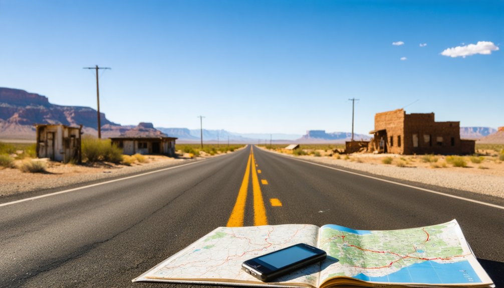
Seven distinct ghost towns lie within a three-hour radius of Las Vegas, forming natural loops along US-95 and US-93 toward Grand Canyon West.
You’ll maximize ghost town photography opportunities by grouping sites geographically: tackle Nelson and Goodsprings in a half-day southern sweep, then dedicate another day to Rhyolite via US-95 north.
The primary route follows US-93 south through Chloride to Grand Canyon West, covering 250 miles with overnights recommended near Death Valley Inn.
You’ll need high-clearance vehicles for gravel roads at Eldorado Canyon. Fuel up in Goodsprings—services grow sparse beyond civilization.
Respect historical preservation by avoiding unauthorized mine entries and private property at Nelson’s Techatticup operations.
Spring through fall offers ideal conditions; summer heat exceeds 100°F in these desert valleys.
What to Bring When Exploring Abandoned Mining Sites
Your route mapped and vehicle fueled, you’ll need specialized equipment to safely explore these deteriorating mine sites that date back to Nevada’s 1900s silver and gold rushes.
Essential supplies include a hard hat for protection against unstable ceiling debris, protective eyewear for dust-filled shafts, and sturdy work boots with reflective strips for traversing dark passages.
Cap lamps and backup flashlights are non-negotiable in these lightless environments. Pack a respirator rated for toxic gases—many abandoned workings contain harmful fumes from century-old chemical processes.
Bring a gas detector to monitor oxygen levels and carbon monoxide before entering any structure. Your safety gear should also include puncture-resistant gloves, high-visibility clothing, and a well-stocked first aid kit.
Communication devices guarantee you’re never truly isolated in these remote locations.
Best Times of Year to Visit Desert Ghost Towns

Planning your ghost town expedition between Vegas and the Grand Canyon requires careful consideration of Nevada and Arizona’s extreme desert climate patterns, where seasonal temperature swings of 60°F can transform the same abandoned mining settlement from accessible heritage site to dangerous exposure risk.
Spring exploration delivers ideal conditions with 60-75°F temperatures and wildflower blooms across desert valleys. You’ll navigate remote sites without monsoon flash floods threatening canyon approaches.
Summer challenges intensify when temperatures exceed 100°F, demanding increased water reserves and limiting safe exploration windows to early morning hours.
Fall festivities bring moderate 70-85°F weather and heritage events like Oatman’s September Burro Biscuit Toss, while Vulture City stages gunfight performances October through May.
Winter celebrations transform Virginia City into “Christmas on the Comstock” with Candy Cane Express rides and Piper’s Opera House performances throughout December.
Frequently Asked Questions
Are Ghost Town Visits Safe for Children and Families?
Ghost town safety varies greatly by location. You’ll find family-friendly activities at well-preserved sites with maintained structures, but abandoned properties pose real hazards—unstable buildings, lead exposure, and isolated conditions require careful research before visiting with children.
In addition to safety considerations, exploring historic inns in ghost towns can provide a unique glimpse into the past. These accommodations often offer a blend of charm and history, attracting visitors interested in both adventure and storytelling. As you plan your journey, be sure to include a few of these intriguing stops to enrich your experience.
Can I Camp Overnight Near These Ghost Towns?
Yes, you’ll find dispersed camping on BLM lands surrounding most ghost towns, though camping regulations vary by location. Nearby established campgrounds offer alternatives, but overnight permits aren’t typically required for dispersed sites on public land.
Do I Need a Four-Wheel Drive Vehicle to Reach These Sites?
You won’t need off-road vehicles for main ghost towns like Nelson, Rhyolite, Oatman, and Calico. However, exploring remote mining camps and backcountry areas presents terrain challenges requiring high-clearance or four-wheel-drive capability.
Are There Guided Tours Available for Multiple Ghost Towns?
Yes, you’ll find guided tour options covering popular ghost towns like Oatman, Chloride, and El Dorado Canyon. Bindlestiff and Howlanders offer Saturday departures visiting multiple sites, while combination tours include Grand Canyon stops for extended exploration.
What Photography Restrictions Exist at These Historic Mining Sites?
Like shutterbugs maneuvering minefield markers, you’ll face varying photography etiquette rules: Nelson demands waivers plus fees, Gold King Mine prohibits climbing structures, while Nevada’s site regulations ban nudity, require permits for commercial work, and restrict drone usage statewide.
References
- https://nvtami.com/top-10-ghost-towns-nevada-northwest/
- https://goldfieldghosttown.com
- https://savingplaces.org/stories/explore-wild-west-mining-history-in-nevada-ghost-towns
- https://westernmininghistory.com/state/nevada/
- https://en.wikipedia.org/wiki/List_of_ghost_towns_in_Nevada
- https://www.youtube.com/watch?v=Bp2IcEQsWEM
- https://travelnevada.com/ghost-town/
- https://www.visittheusa.com/experience/6-nevada-ghost-towns-explore-if-you-dare
- https://www.worldatlas.com/cities/7-quirky-little-towns-in-nevada.html
- https://shpo.nv.gov/nevadas-historical-markers/historical-markers/goodsprings


