You’ll find six authentic ghost towns within 90 minutes of Denver, each preserving Colorado’s 1859 gold rush legacy. Nevadaville sits at 9,000 feet with just six residents and an operational Masonic lodge, while Apex maintains one year-round inhabitant at nearly 10,000 feet elevation. Mount Vernon once served as Jefferson Territory’s capital, and Dyersville requires high-clearance 4WD for its final approach. Teller City’s complete abandonment by 1902 left only wilderness remnants, and Homestead Meadows reveals agricultural foundations from ranching families who persisted until 1952—each location offering distinct historical perspectives on Colorado’s mining heritage.
Key Takeaways
- Nevadaville, at over 9,000 feet in Gilpin County, once housed 4,000 residents during the 1859 Gold Rush era.
- Apex, founded in 1891 at 9,842 feet elevation, grew to 1,000 residents with over 80 commercial buildings.
- Dyersville lies 6 miles south of Breckenridge, accessible via Boreas Pass with high-clearance 4WD required for final approach.
- Mount Vernon, founded in 1859, served as Jefferson Territory’s de facto capital with up to 50 wagons passing daily.
- Most ghost towns feature preserved structures, cemeteries, mine shafts, and cabin ruins available for free exploration with caution.
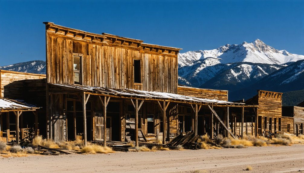
Nevadaville
Perched at over 9,000 feet in the Rocky Mountains of Gilpin County, Nevadaville sprang to life in 1859 during the Pike’s Peak Gold Rush as miners flooded Gregory Gulch in search of fortune.
You’ll find this former boomtown—initially called Nevada—once housed nearly 4,000 residents, surpassing Denver’s population at its peak. Irish miners worked the Burroughs and Kansas Lodes while thirty mills processed ore from surrounding claims.
Today’s ghost town preservation efforts maintain several original structures, including the 1859 Masonic Lodge, City Hall, and historic saloons.
You’re free to stroll Main Street, though hazardous sinkholes from outdated mining techniques restrict exploration.
With only six full-time residents remaining, Nevadaville stands as a monument to Colorado’s untamed past, surrounded by mine ruins and forgotten gravesites. The town’s Nevada Lodge Number 4 continues to hold meetings, making it the only ghost town lodge still operational in Colorado. Located just west of Central City, the ghost town sits under an hour’s drive from Denver via I-70, making it one of the most accessible abandoned mining towns in the state.
For those seeking unique adventures, exploring ghost towns near Las Vegas offers a fascinating glimpse into the history of the Old West. Destinations like Rhyolite and Nelson provide an eerie yet captivating experience, with remnants of the past surrounded by stunning desert landscapes. Visitors can immerse themselves in the stories of abandoned homes and winding roads that once bustled with life during the gold rush era.
Apex
Founded in 1891 at 9,842 feet elevation, Apex served as the capital of Pine Creek Mining District and grew to approximately 1,000 residents by 1900, supporting over 80 commercial buildings, two hotels, and its own newspaper, the *Apex Pine Cone*.
You’ll find this northwest of Central City, where wildfires and mine depletion reduced the once-thriving community to scattered remnants including a false-fronted hotel marked by a brass medallion as Gilpin County’s first historical register site.
Today you can explore four old cemeteries and surviving structures via Apex Valley Road off CO 119, following an 11.4-mile trail that reveals both the community’s prosperous mining past and its gradual evolution to ghost town status after the post office closed in 1932. The route remains open year-round for exploration and connects to various other trails in the area. One year-round resident, known as the Mayor of Apex, still calls this ghost town home.
Paired Mining Community History
While neighboring towns like Nevadaville and Central City had already established themselves during the 1859 Pikes Peak Gold Rush, Apex didn’t emerge until 1891, three decades after its more prominent neighbors.
You’ll find Apex history reveals a different timeline than traditional Colorado mining camps. Richard Mackey’s 1870s prospecting eventually led to a dramatic discovery when a final dynamite blast exposed ore worth $1,800 per ton. This sparked rapid development in the Pine Creek Mining District.
By the late 1890s, Apex mining operations supported 1,000 residents and over 100 businesses along Main Street. The town became the district’s designated capital, complete with its own newspaper, the *Apex Pine Cone*, launched in 1897. The community featured saloons and dance halls that served the mining population.
This late-blooming community thrived independently despite its established neighbors. Like other mining towns, Apex depended on transportation advancements such as railroads to move ore and supplies between the camps.
Accessible Ruins and Remnants
Today’s visitors to Apex will discover a ghost town that’s yielded far more to time than its neighbor Nevadaville. You’ll find scattered wooden foundations and collapsed cabins dotting the hillside at 9,500 feet elevation.
The cemetery remains intact, preserving gravesites from the 1870s gold rush era. Defunct mine shafts and tailings mark the ghostly landscapes where fortune-seekers once worked.
Few abandoned buildings persist compared to nearby sites. Historical remnants include remnants of structures you can reach via dirt road from Nevadaville, though 4WD’s recommended.
The ruins sit in moderate decay surrounded by forested hills and old mine works. You’re free to explore without entry fees, but watch for uneven terrain and mine hazards. Some towns are covered in mining tailings that obscure the original settlement sites.
Little remains beyond foundations and graves from this community abandoned by the early 1900s. At its peak, this bustling mining camp housed over 1,000 residents and 100 businesses.
Mount Vernon
In the fall of 1859, Dr. Joseph Castro founded Mount Vernon in Jefferson County as a staging area for miners heading to Black Hawk and Central City’s gold discoveries. Named after George Washington’s Virginia estate, this settlement achieved remarkable historic significance as the de facto capital of Jefferson Territory from 1859-1861, where Governor Robert W. Steele resided and hosted government meetings.
During its two-year heyday, up to 50 wagons passed through daily along the toll road, supporting a mining legacy that included dozens of cabins, two hotels, and essential services. Castro built a toll road connecting Mount Vernon to the mining camps and offered free land plots to encourage construction.
Federal recognition of Colorado Territory in 1861 triggered Mount Vernon’s decline. Among the last residents were William Matthews and family, who owned historic properties that helped preserve the town’s legacy.
Today, you’ll find two stone buildings—one now offering rustic lodging—and Mount Vernon Cemetery, where Reverend Isaiah Rogers Dean and James H. Judy rest beneath marked graves.
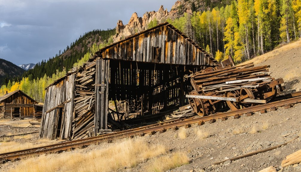
Dyersville
You’ll find Dyersville at 10,880 feet in Indiana Gulch, six miles southeast of Breckenridge, where Methodist minister John Lewis Dyer established his settlement in January 1881.
The town’s economy depended entirely on the Warrior’s Mark Mine until its closure in 1908 triggered rapid abandonment.
Today you can reach the site by foot, mountain bike, or high-clearance vehicle to explore roofless log cabin walls, including Dyer’s original 17-foot square cabin, plus remnants of the livery stable, boarding house, and Angels Rest saloon.
Gold Rush Mining History
John Lewis Dyer’s arrival in Colorado territory during 1861 marked the beginning of a unique fusion between Methodist ministry and frontier mining enterprise.
You’ll find his background in Wisconsin lead mining proved invaluable when he staked claims across Colorado’s mountain districts. His unconventional mining techniques included using a dousing stick to locate valuable veins, supplementing meager ministerial wages.
The Warriors Mark Mine exemplified his dual calling:
- Log cabin construction began January 1881 near Indiana Gulch workings
- Mining expertise from Wisconsin informed claim selections throughout the territory
- Economic necessity drove continuous prospecting between ministry circuits
Historical artifacts from this period reveal how lode mining replaced earlier placer operations after railroad arrival in 1869.
You’re exploring a settlement born from gold discovery, where approximately 1.25 million ounces entered America’s economy during Colorado’s rush.
Mountain Access and Location
Dyersville’s remote position in Indian Gulch, 6 miles south of Breckenridge, demands careful planning before you attempt the journey.
You’ll reach the site via Boreas Pass from either Breckenridge or Como, traversing dirt roads at 10,879 feet elevation. While 2WD vehicles handle main routes, the final half-mile requires high-clearance 4WD. Look for the U.S. Forest Service sign marking “Indiana Creek, Pennsylvania Creek” at the gulch entrance, then follow Indiana Creek 4WD road (FR 593) to reach the townsite.
Summer offers your best access window—winter snow blocks passage for months. You can explore on foot, mountain bike, or appropriately equipped vehicle.
The Warrior’s Mark Mine sits a quarter-mile up from town on particularly rough terrain, making vehicle preparation essential for unrestricted exploration.
Exploring Abandoned Structures
Scattered across this high-elevation site, nearly a dozen log cabin remains offer tangible connections to Dyersville’s brief existence as a mining settlement.
You’ll find ghostly remnants of abandoned architecture throughout this 10,880-foot location, with each structure telling stories of the 1880s mining boom.
Key discoveries include:
- A 17-foot square pile of rotting logs, likely Father Dyer’s original cabin and church
- Ruins of the livery stable and boarding house near the town center
- Angels Rest Saloon remains, located a few hundred feet from downtown
You can explore roofless walls and rusty mining equipment that mark where miners once defied Dyer’s pious intentions.
The Warrior’s Mark Mine sits a quarter-mile up a rough dirt road, accessible to those seeking Summit County’s authentic frontier heritage.
Homestead Meadows
You’ll find no post office or saloons here—just scattered ranches connected by fifteen miles of wagon roads.
Men walked creek beds to work in nearby Lyons while women maintained the properties.
Daily life meant men trekking miles through rugged creeks for work while women shouldered the demands of ranch survival alone.
This agricultural heritage lasted until 1952 when economic pressures finally emptied the valley.
Today, you can hike 2.5 miles to explore remaining foundations and sawmill equipment.
Teller City
Deep in the mountains southwest of Gould, Teller City sprang to life in 1879 when Mador Kushman discovered silver and filed Grand County’s first mining deed.
Named after Senator Henry M. Teller, a champion of silver’s monetary value, this settlement at 8,200 feet swelled to over 1,500 residents by 1882.
Teller City history showcases boom-and-bust extremes:
- The 40-room Yates House Hotel anchored a town with 27 saloons and hundreds of cabins
- Silver mining prosperity vanished when prices crashed in 1884
- By 1902, complete abandonment left only wilderness
You’ll find scattered foundations and a few surviving cabins accessible via County Road 21 from Gould.
The final three miles demand high-clearance 4×4 vehicles.
Roosevelt National Forest now reclaims this remote site where dispersed camping and OHV riding attract modern explorers.
Frequently Asked Questions
Do I Need Special Permits to Explore Ghost Towns Near Denver?
You don’t need special permits for most ghost towns near Denver. With over 600 Colorado ghost towns documented, exploration regulations remain minimal, though you should respect historical preservation efforts and private property boundaries while exploring freely.
Are Ghost Towns Near Denver Safe to Visit With Children?
Many ghost towns near Denver prioritize child safety through preserved structures and maintained access roads, though you’ll need supervision around historic mining equipment. Their historical significance offers educational value while exploring Colorado’s heritage responsibly together.
What Is the Best Time of Year to Visit Colorado Ghost Towns?
Summer and early fall offer you the best access to Colorado’s ghost towns. You’ll experience comfortable hiking weather, stunning fall foliage in late September, and fewer winter road closures limiting your exploration freedom.
Can I Camp Overnight at Ghost Town Sites Near Denver?
Think of ghost towns as museums without walls—you can’t camp within their boundaries. Ghost town amenities don’t include overnight facilities, but camping regulations permit dispersed sites in surrounding national forests with proper permits.
Are There Guided Tours Available for Denver Area Ghost Towns?
You’ll find guided tours focusing on Denver’s ghost towns are limited, but several ghost tour companies operate in the city, emphasizing historical significance through storytelling about haunted sites rather than abandoned settlements outside metro Denver.
References
- https://www.uncovercolorado.com/ghost-towns-near-denver-co/
- https://en.wikipedia.org/wiki/List_of_ghost_towns_in_Colorado
- https://www.colorado.com/articles/colorado-ghost-towns
- https://www.uchealth.org/today/ghost-towns-abound-in-colorado/
- https://www.amli.com/blog/abandoned-mines-and-ghost-towns-near-denver
- https://www.americansky.co.uk/colorado-holidays/exploring-colorados-ghost-towns
- https://www.uncovercolorado.com/ghost-towns/
- https://www.adventurable.com/views/ghost-towns-ruins
- https://www.islands.com/1871943/nevadaville-colorado-gold-rush-hub-haunted-abandoned-ghost-town/
- https://www.legendsofamerica.com/nevadaville-colorado/


