
You’ll discover America’s dam-building era created haunting underwater ghost towns from St. Thomas, Nevada—submerged in 1938 by Lake Mead—to four Massachusetts communities erased for Quabbin Reservoir. These projects displaced thousands through eminent domain, often compensating residents unfairly while prioritizing water supply and hydroelectric power over local autonomy. Native American tribes suffered most dramatically, losing over 1.13 million acres to 424 dams that flooded sacred sites and ancestral lands. The stories behind these submerged settlements reveal broader tensions between infrastructure development and community preservation.
Key Takeaways
- St. Thomas, Nevada was submerged by Lake Mead in 1938 following Hoover Dam construction, with ruins reemerging in 2002.
- Four Massachusetts towns—Dana, Enfield, Greenwich, and Prescott—were completely erased between 1933-1946 to create Quabbin Reservoir.
- Kennett, California disappeared beneath Shasta Lake between 1938-1945 as federal authorities prioritized flood control and hydroelectric generation.
- Twelve New York communities were displaced for Ashokan Reservoir construction from 1907-1915, affecting over 2,000 residents with minimal notice.
- Tennessee River dam construction submerged thriving settlements like Danville, now marked by a grain elevator beneath Kentucky Lake.
St. Thomas: Nevada’s Drowned Desert Settlement
When Mormon pioneers established St. Thomas in 1865, they couldn’t foresee their desert Mormon Settlement would become America’s most dramatic sacrifice to progress.
St. Thomas settlers built their future in Nevada’s desert, never imagining Lake Mead would swallow their town whole.
You’ll find this community’s story reveals how federal infrastructure projects reshape human geography. The town thrived for decades at the Muddy and Virgin Rivers’ confluence, surviving even territorial disputes that briefly drove settlers back to Utah. Residents built a self-sufficient farming hub connected by railroad to major western cities.
Then came Hoover Dam. President Coolidge’s 1928 authorization sealed St. Thomas’s fate. By 1938, Lake Mead‘s waters claimed everything under 50-80 feet of reservoir. The last citizen, Hugh Lord, departed on June 11, 1938, marking the final chapter of habitation.
Today’s droughts expose these ruins, offering you tangible evidence of development’s human cost and nature’s power to reclaim what progress takes. The town first reemerged in 2002 when dropping water levels revealed structures like the Hanning Store and Ice Cream Parlor.
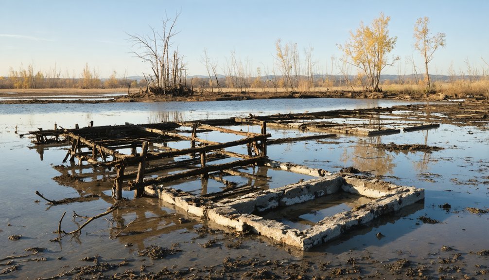
The Ashokan Reservoir Displacement of New York Communities
When you examine the Ashokan Reservoir’s creation between 1907 and 1915, you’ll find that New York City’s exercise of eminent domain dismantled twelve communities and displaced over 2,000 residents who’d built lives across 13 square miles of farmland and villages.
The compensation process reveals the power imbalance inherent in early 20th-century infrastructure projects: families received as little as 10 days’ notice to vacate, property valuations systematically favored the city, and the $15 payment per grave relocation quantified loss in ways that sparked legal battles extending to 1940.
You’re witnessing how urban water demands transformed rural landscapes into what became the world’s largest reservoir, a 122.9-billion-gallon supply system that prioritized metropolitan needs over established agricultural communities. The construction required submersion of thousands of acres of farmland, permanently altering the region’s agricultural character and economy.
The reservoir’s completion in 1916 marked the beginning of its service as a primary water supply for NYC, providing approximately 40% of the city’s daily drinking water in non-drought periods.
Twelve Communities Destroyed
Between 1907 and 1915, the construction of New York City’s Ashokan Reservoir erased a thriving agricultural valley in the Catskill Mountains, displacing approximately 2,350 residents and destroying twelve distinct communities that had anchored the region’s economy for generations.
You’ll find that four hamlets—Brown’s Station, Olive City, Broadhead’s Bridge, and Ashton—disappeared beneath twelve miles of backed-up Esopus waters. Eight additional communities, including West Hurley and Shokan, were forcibly relocated to nearby foothills.
The impact of urban development and shifting environmental conditions has led to the emergence of lost communities in the Bay Area. Many residents are now grappling with the historical significance of these areas, as well as the cultural heritage that has been irretrievably altered. Efforts are being made to document these narratives, ensuring that the memories of these places are not forgotten.
The environmental impact extended beyond submerged farmland: workers demolished 500 homes, 35 stores, 10 churches, and eight mills while exhuming over 2,500 bodies from cemetery grounds.
The reservoir, completed in 1915, held 122.9 billion gallons, making it the largest in the world at that time.
The Town of Olive was split in two during construction, causing particularly severe disruption to its residents and community structure.
These community memories persist despite New York City’s needs overwhelming local autonomy, transforming a productive valley into municipal infrastructure.
Compensation and Relocation Costs
As New York City officials exercised eminent domain over 12,000 acres of Catskill farmland, they imposed compensation rates that systematically undervalued displaced residents’ properties and livelihoods, creating economic hardships that compounded the social devastation of forced removal.
You’ll find displacement struggles documented throughout contemporary accounts, where property owners received below-market prices without challenge mechanisms. The city determined compensation unilaterally—many residents weren’t paid full property value despite legal requirements.
Compensation fairness became particularly questionable when families received just $15 per grave for disinterment costs while losing generational homesteads. The construction of dams began in 1907, marking the physical transformation of these communities into the reservoir that would eventually supply New York City with a significant portion of its water. The completed watershed system would ultimately provide 1.1 billion gallons of water daily to meet the growing needs of the expanding city.
Within two months, sometimes one week, 2,350 residents had to uproot their lives under these imposed conditions. This pattern of governmental overreach, affecting 4,464 people across seven reservoirs, demonstrates how infrastructure projects can sacrifice individual rights for collective urban needs.
California’s Shasta Lake and the Lost Valley Towns
The flooding of California’s Sacramento River valley for Shasta Lake between 1938 and 1945 represents a pivotal case study in how mid-20th century infrastructure development reshaped regional communities and landscapes.
You’ll find that Kennett, the valley’s primary settlement, disappeared beneath 4.5 million acre-feet of stored water as federal authorities prioritized flood control and hydroelectric generation over local autonomy.
The Central Valley Project, initially funded through state bonds in 1933, shifted to federal control when Depression-era California couldn’t finance construction independently. This transferred decision-making power from regional voters to Washington bureaucrats.
Lost towns like Kennett became necessary sacrifices for broader economic planning, illustrating how centralized infrastructure projects routinely subordinated individual property rights and community preservation to collective resource management goals during America’s New Deal expansion.
Construction required millions of tons of rock to excavate down to bedrock before concrete placement could begin, fundamentally altering the valley’s geological profile. The project utilized 6.5 million cubic yards of concrete to build Shasta Dam, one of the largest concrete structures of its era.
Four Massachusetts Towns Vanished Beneath Quabbin Reservoir
Between 1933 and 1946, you witness one of America’s largest peacetime displacements as Massachusetts deliberately erased four towns—Dana, Enfield, Greenwich, and Prescott—to create the Quabbin Reservoir.
This wasn’t merely infrastructure development; it represents a critical shift in how democratic states balanced individual property rights against collective urban needs, with 2,500 residents losing their homes through eminent domain while their dead were exhumed and relocated.
The project’s scale—razing entire communities, burning valleys for months, and flooding 39 square miles—reveals the social costs embedded in modern water systems that continue to shape metropolitan Boston today.
Windsor Dam Construction Timeline
Long before construction crews broke ground, Massachusetts officials spent three decades maneuvering political opposition and engineering challenges to transform the Swift and Ware River valleys into what would become the Commonwealth’s most ambitious water supply project.
The 1895 concept finally gained legislative authorization in 1926, but Connecticut’s fierce resistance delayed Windsor Dam construction until 1933, following a hard-won Supreme Court victory in 1931.
You’ll find the dam’s hydraulic fill method created a 2,640-foot barrier that took six years to complete by 1939. Chief Engineer Frank E. Winsor directed the interconnected infrastructure—aqueducts, dams, and diversions—that required unprecedented coordination.
When rivers finally flowed into the basin that year, seven additional years passed before the reservoir reached capacity in 1946.
Displaced Communities and Population
When Massachusetts legislators condemned the Swift River Valley in 1938, they erased four self-governing towns—Dana, Enfield, Greenwich, and Prescott—that had anchored rural life in the region for over a century.
You’ll find no trace of the 2,500 residents who called these places home, forced from 650 houses without job assistance or relocation programs.
The state dismantled everything: 14 mills, six churches, 13 schools, and 36 miles of highway that connected these communities to broader commercial networks.
Officials even exhumed 7,613 graves from 34 cemeteries, obliterating the physical markers of generational continuity.
This wasn’t just displacement—it represented systematic destruction of community resilience and historical significance.
The farewell ball on April 27, 1938, marked more than nostalgia; it acknowledged power’s capacity to dissolve self-governing communities entirely.
Relocated Graves and Landmarks
The state’s handling of 7,613 bodies from 34 cemeteries reveals how infrastructure projects commodify even the dead, transforming sacred burial grounds into logistical obstacles.
You’ll find grave relocation became bureaucratic theater—80% moved to Quabbin Memorial Park Cemetery via individual hearses, while submerged tombstones and a mausoleum discovered by 1990s divers expose the operation’s incompleteness.
Families could choose alternative sites, yet the state’s memorial preservation prioritized appearances over thoroughness.
This systematic clearance before 1938’s disincorporations demonstrates how authoritarian planning erases community memory alongside physical structures.
The underwater gravestones serve as permanent evidence that government efficiency claims often mask rushed, incomplete work—a warning about sacrificing cultural heritage for centralized resource control that resonates beyond Massachusetts’ flooded valley.
Tennessee River Communities Sacrificed for Hydroelectric Power
As the Tennessee Valley Authority pursued ambitious modernization plans during the New Deal era, entire river communities became casualties of progress, their erasure from the landscape deemed necessary for regional economic development.
You’ll find that dam construction along the Tennessee River transformed thriving settlements into submerged ruins. Danville’s grain elevator, once serving as a crucial agricultural hub between Memphis and Louisville, now stands as a skeletal monument beneath Kentucky Lake.
The Hales Bar Dam flooded an entire city, leaving Long Cemetery’s bodies unretrieved underwater. These sacrifices for hydroelectric power reveal an uncomfortable truth: government planners valued energy generation over community preservation, forcing thousands to abandon ancestral lands.
The drowned towns remain as cautionary tales about centralized authority’s willingness to reshape landscapes regardless of human cost.
The Staggering Loss of Native American Tribal Lands
While Tennessee Valley communities vanished beneath hydroelectric reservoirs, Native American tribes experienced losses of even greater magnitude—both in scale and cultural devastation.
You’ll find this land dispossession staggering in scope:
- 424 dams flooded over 1.13 million acres of tribal land—an area larger than Rhode Island
- Fort Berthold Indian Reservation lost 152,000 acres to Garrison Dam, displacing 80 percent of tribal members
- 95 percent of Fort Berthold’s agricultural land disappeared underwater, destroying entire towns and tribal headquarters
- Columbia River dams decimated salmon runs that sustained Northwest tribes for millennia
This cultural impact extends beyond acreage.
Dam construction violated treaties guaranteeing perpetual land ownership, flooding sacred sites, ancestral burial grounds, and traditional fishing settlements.
The federal government intentionally disregarded tribal cultures, economies, and homes—turning sovereignty into another broken promise.
The Human Cost of America’s Dam Building Era
Native American reservations weren’t the only communities shattered by America’s dam-building ambitions—they represented one chapter in a global catastrophe that displaced between 40 and 80 million people worldwide.
You’ll find displacement statistics reveal a staggering reality: approximately one million people per year were uprooted by development programs during peak construction decades, exceeding displacement from war and natural disasters.
The social impacts extended far beyond mere relocation. Forced resettlement destabilized entire communities, erasing traditional livelihoods and converting self-sufficient populations into what Indian activists called “oustees”—politically invisible refugees who disappeared into urban poverty.
Over half a billion people lost economic security when dams destroyed river ecosystems supporting fisheries and agriculture. These weren’t unfortunate side effects—empirical evidence confirms impoverishment was the widespread, predictable consequence of development-caused resettlement that planners systematically ignored.
Frequently Asked Questions
Can Scuba Divers Legally Explore Submerged Ghost Towns in Reservoirs?
You’ll navigate a legal maze as complex as Shi Cheng’s 130-foot depths. Underwater regulations vary by site, but you can explore with proper diving permits from managing agencies. Freedom requires respecting cultural protections while pursuing adventure through authorized channels.
Were Any Dam Construction Projects Stopped Due to Public Opposition?
You’ll find dam controversies spanning decades resulted in successful public protests halting major projects worldwide. Franklin Dam, Oakley Dam, Myitsone Dam, and Nagymaros Dam were all stopped through persistent citizen action demonstrating democracy’s power over centralized planning.
How Did Relocating Families Choose Where to Move After Displacement?
You’d face relocation challenges with limited autonomy—governments typically assigned new sites rather than offering choices. Community resilience emerged when residents voted collectively, like Niobrara’s 90% approval, though many displaced families lacked meaningful input in their futures.
Are There Underwater Archaeological Expeditions Documenting Submerged Structures?
You’ll find countless underwater archaeology expeditions documenting submerged history—from Lake Geneva’s 1854 pioneering dive to Bulgaria’s Nessebar campaigns mapping fortifications across millennia. These projects reveal how civilizations adapt, preserve heritage, and reclaim lost narratives beneath rising waters.
What Legal Precedents Emerged From Eminent Domain Cases During Dam Construction?
You’ll find eminent domain precedents established government liability for flooding-induced takings, even temporary ones. Legal challenges secured compensation rights for displaced communities and recognized that infrastructure projects triggering property destruction require full ownership transfer and relocation costs.
References
- https://www.wef.org/publications/news/wef-news/ghost-town-emerges-from-the-depths-of-lake-mead/
- https://archaeology.org/issues/may-june-2024/letters-from/ghost-towns-of-the-ashokan-reservoir/
- https://www.uncharted101.com/the-submerged-towns-of-america/
- https://www.tnmagazine.org/tennessees-underwater-ghost-towns/
- https://pmc.ncbi.nlm.nih.gov/articles/PMC10410305/
- https://www.drownedtowns.com/about
- https://storymaps.arcgis.com/stories/124e04142d3147078fb4519a6b9a5c64
- https://en.wikipedia.org/wiki/List_of_flooded_towns_in_the_United_States
- https://travelnevada.com/ghost-town/st-thomas-ghost-town/
- https://www.youtube.com/watch?v=JnIIQymTY3w


