You’ll find Ireland’s abandoned settlements span from medieval Clonmines in County Wexford, established by Norman settlers in the 13th century, to Great Blasket Island, evacuated as recently as 1953 when its Irish-speaking community dwindled to just 22 residents. These ghost towns emerged from distinct catalysts: the Great Famine devastated An Port and Slievemore, Viking raids hollowed out Scattery Island’s monastery, and economic isolation claimed Rindoon’s fortified peninsula. Each site preserves archaeological evidence of the social upheavals that shaped Ireland’s landscape, offering deeper insights into the forces behind these mass departures.
Key Takeaways
- An Port, Donegal’s first maritime port, was abandoned during the Great Famine and features crumbling stone cottages on a hillside.
- Clonmines is Ireland’s most architecturally intact medieval ghost town with surviving churches, monastery, and tower houses from the 13th century.
- Slievemore contains nearly 100 stone cottages from Ireland’s most extensive booley village, abandoned due to famine and evictions.
- Rindoon features well-preserved 13th-century town walls and castle ruins, abandoned following the Black Death and Gaelic resurgence.
- Great Blasket Island’s isolated community declined from 160 residents to 22 before evacuation in 1953 due to harsh conditions.
Port, County Donegal: The Deserted Village on the Wild Atlantic Way
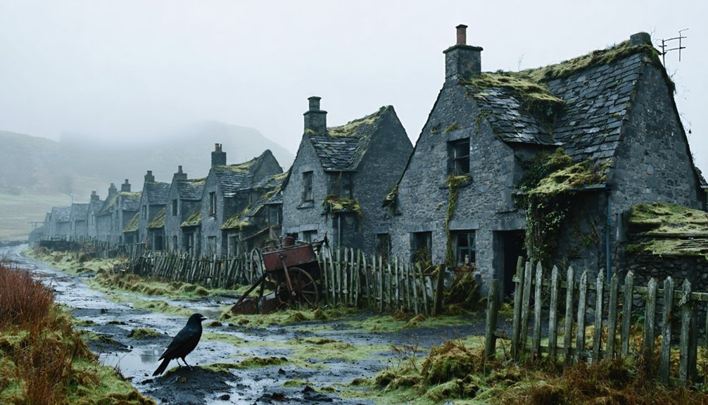
Perched above a wild stoned beach on County Donegal’s Wild Atlantic Way, An Port stands as one of Ireland’s most complete ghost villages—a settlement whose entire population vanished during the Great Famine of 1845-1852.
Unlike neighboring communities where residents remained, this thriving fishing port experienced total abandonment, leaving stone cottages to crumble on the hillside.
Where neighbors endured and rebuilt, An Port saw every last soul depart, their empty homes left to the elements.
The Fisheries Commission of 1836 documented the pier’s deterioration, while 1860s records described unmistakable decline.
The village’s historical significance as Donegal’s first maritime port adds weight to its tragedy.
The stone homes feature clean cut corners, showcasing the skilled craftsmanship of builders who worked with materials drawn from the surrounding coastal landscape.
The village forms part of The Drum Loop hiking route, offering visitors a scenic coastal trail that continues over mountain terrain back to Glencolmcille.
Local legends intensify the haunting atmosphere—particularly tales of Siobhan Neill, allegedly murdered while escaping an arranged marriage, her spirit still wandering the hills.
You’ll find this remote ruin accessible via narrow laneway, offering unfiltered access to Ireland’s darker heritage.
Clonmines, County Wexford: A Norman Medieval Masterpiece Frozen in Time
Along the silted shores of Bannow Bay, Clonmines sprawls across 20 acres as Ireland’s most architecturally intact medieval ghost town—a Norman borough whose stone edifices document seven centuries of mercantile ambition and inevitable collapse.
As you venture beyond its historical confines, the rugged landscapes of the region beckon adventurers to explore the intriguing ghost towns near Carlsbad Caverns. Many of these abandoned settlements tell tales of resilience and hardship, remnants of a time when mining prospered but ultimately faded into obscurity. Each site offers a haunting glimpse into the past, inviting visitors to ponder the lives once lived within their faded walls.
You’ll find the historical significance etched in its surviving medieval architecture: two churches, a monastery, two tower houses, and the haunting Cowboy’s Chapel with twin turrets.
William Marshal established this 13th-century port as an alternative to New Ross, exploiting nearby silver and lead deposits that fueled prosperity through Bannow Bay’s harbour.
The 1300s witnessed Clonmines functioning as a judicial and industrial powerhouse, its main road connecting Wexford to coastal trade routes. The settlement included medieval friaries that served the spiritual needs of the bustling merchant community.
Yet sand’s relentless accumulation choked the harbour, strangling commerce. By the 17th century, inhabitants abandoned their fortified settlement, leaving you private farmland ruins visible only from Wellington Bridge’s cemetery. The borough once held such political importance that it returned two members to the Irish parliament before the Union, receiving £15,000 in compensation when its franchise was abolished.
Slievemore, County Mayo: Achill Island’s Hauntingly Beautiful Stone Village
Beneath the stark slopes of Slievemore Mountain, nearly 100 stone cottages trace a 1.5-kilometer pathway that documents Ireland’s most extensive booley village—a settlement whose 5,000-year occupation ended catastrophically during the Great Famine.
The abandonment reasons converge in the 1840s: potato blight, emigration, exhausted land holdings, and suspected evictions following external takeover. Griffith’s Valuation survey (1847-1852) captured residents’ names before desertion displaced them toward coastal fishing communities.
The archaeological significance extends beyond famine-era tragedy:
- Neolithic megalithic tombs marking 5,000 years of continuous habitation
- Bronze Age roundhouse discovered during 2009-2010 excavations
- Medieval field systems revealing agricultural practices
- Post-1850 transformation into Ireland’s last functioning booley settlement until the 1940s
Annual Archaeological Field Schools now excavate artifacts spanning millennia, preserving evidence of transhumance traditions and famine displacement on this remote Atlantic island. The cottages appear frozen in time, their stone walls offering visitors a glimpse into the hardships endured by generations of inhabitants who once called this mountainside home. Sheltered beneath Slievemore’s peak, the site provides tranquil solitude for those seeking reflection on Ireland’s complex rural heritage.
Galboly, County Antrim: From Forgotten Settlement to Game of Thrones Fame
While Slievemore’s stone cottages testify to Ireland’s western famine devastation, the Antrim coast reveals a different trajectory of rural abandonment. You’ll find Galboly nestled in Ardclinis parish near Carnlough, where “the English dairy place” once housed 48 families during the 1850s.
Galboly history chronicles economic collapse through agricultural mechanization—steep mountainside terrain couldn’t accommodate modern equipment, forcing subsistence farmers into irrelevance. By 1951, only six residents remained. The last inhabitant, a monk from Portglenone Abbey, lived in the village until 2013.
The village reputation as a “robber’s village” persists without documentary evidence. Locals claimed inhabitants ambushed tourists traveling the coastal road between the 1800s-1960s, yet no criminal records substantiate these allegations.
This stigma likely reflected class tensions between isolated communities and passing travelers. The abandoned stone-built cottages, mostly one-storey structures with fireplaces for heating and cooking, initially featured thatched roofs later replaced with aluminum sheets. Today’s crumbling stone walls attract Game of Thrones location scouts, transforming outlaw mythology into cinematic capital.
Rindoon, County Roscommon: The Fortified Peninsula Lost to History
If you cross the peninsula neck at Rindoon, you’ll encounter a twenty-foot-high town wall stretching 1,640 feet—physical evidence of a thirteenth-century royal borough that controlled the Shannon frontier between Anglo-Norman Leinster and Gaelic Connacht.
The strategic position on Lough Ree’s western shore, nine miles north of Athlone, made Rindoon both a military stronghold and trading center, evidenced by surviving structures including Geoffrey de Marisco’s 1227 castle and a three-story cylindrical windmill.
The settlement’s abandonment after the fourteenth century, accelerated by Gaelic resurgence and the Black Death, left you with one of Europe’s best-preserved medieval ghost towns, now reduced to farmland ruins inaccessible to the public. The site’s name, Rinn Dúin, meaning “fort of the promontory,” suggests earlier occupation before the Normans arrived in 1227. At its peak, the town supported approximately 1,000 residents, a substantial population when compared to London’s 20,000 inhabitants during the same period.
Medieval Ruins and Structures
Perched on a peninsula jutting into Lough Ree, Rindoon stands as Ireland’s best-preserved medieval town—a designation that carries considerable weight given its completeness and archaeological integrity.
The site’s medieval architecture reveals the ambitious scale of 13th-century Anglo-Norman settlement, while its archaeological significance lies in what it teaches about cultural conflict and urban planning.
You’ll discover these surviving structures across the landscape:
- Castle ruins built in 1227, once among Connacht’s largest Anglo-Norman fortifications
- Town walls spanning 2,000 meters with a 20-foot height, enclosing 25 hectares
- Three-story cylindrical windmill from the 17th century, standing on medieval foundations
- 12th-century hospital predating the walled settlement
Visible house plots and gardens frozen in time offer rare evidence of daily medieval life before abandonment.
Strategic Location on Lough Ree
Rindoon’s founders chose this peninsula on Lough Ree’s western shore with military precision.
You’ll find it jutting into the lake nine miles north of Athlone, positioned strategically between Norman strongholds. The site’s military significance became apparent in 1200-1201 when Anglo-Normans established their bridgehead into Connacht.
They understood geography: the headland’s three water-protected sides required fortification only across the narrow landward approach. By 1227, a royal castle and garrison commanded this frontier between the Anglo-Norman colony and Gaelic O’Conor territories.
The economic impact followed military control—a royal borough emerged by 1236, creating a trading frontier between Connacht and Leinster.
However, isolation from major trade centers ultimately proved fatal to this strategic outpost’s survival.
Abandonment in 14th Century
Within eighty-eight years of its founding, Rindoon’s strategic value collapsed under the weight of its own vulnerabilities. When Ruaidhrí Ó Conchobhair attacked in 1315, he shattered the illusion of Norman permanence. The resurgent Gaelic power forced complete abandonment by century’s end, transforming this once-vital fortress into one of Europe’s best-preserved medieval settlements.
Multiple pressures converged to seal Rindoon’s fate:
- Remote location proved indefensible against determined local chieftains
- Military garrison costs exceeded any economic return from limited trade
- Black Death potentially devastated the already-struggling population
- Distance from major commercial centers strangled economic viability
You’ll find this historical significance echoes a pattern: centralized control can’t sustain outposts when local resistance persists and economics fail.
Rindoon’s ruins stand as evidence to overreach.
Miners’ Village, Glendalough: County Wicklow’s Abandoned Mining Community
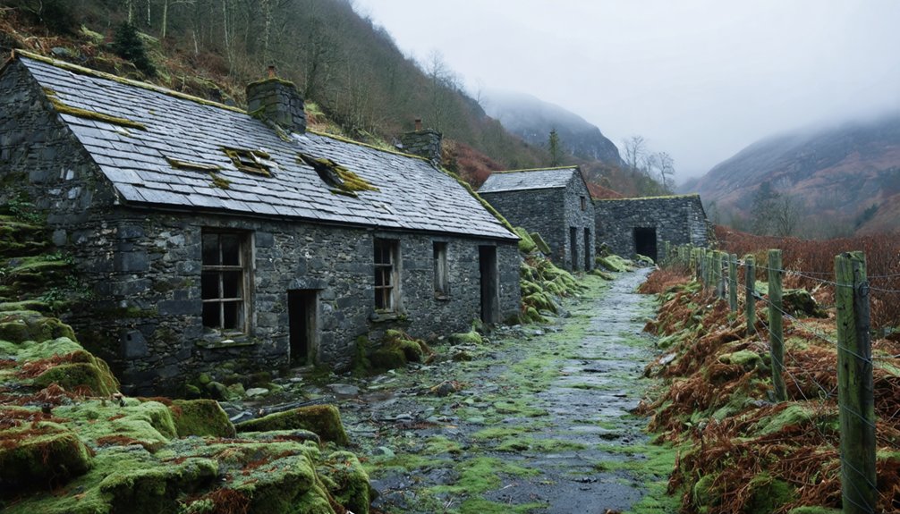
Nestled at the head of Glendalough Valley in County Wicklow, the stone ruins overlooking Upper Lake represent one of Ireland’s most picturesque industrial sites—though the label “Miners’ Village” has proven historically inaccurate.
These ghostly remnants served as ore processing floors, not residential quarters. Lead mining operations spanned 1825-1957 across three ownership phases, extracting galena with silver traces from the Luganure vein.
The structures processed lead ore, not miners—industrial remnants from operations that extracted galena across thirteen decades of Wicklow mining history.
The site reached its zenith during the 1850s-60s under Captain Clemes’s management, when dressing floors costing over £1,000 were constructed above the lake. Rusted crushers still mark where ore was processed before transport.
The actual mining community existed in neighbouring Glendasan Valley, connected through mountain tunnels.
Today, these industrial ruins form part of Wicklow Mountains National Park‘s mining heritage.
Great Blasket Island, County Kerry: The Island Evacuated in 1953
If you’d examined life on Great Blasket before 1953, you’d have witnessed a community struggling with deteriorating conditions—absent sanitation, inadequate food supplies, and substandard housing compounded by complete isolation from emergency services.
The island’s population collapse tells the story: women dropped from 45% in 1911 to just 29% by 1947, as they chose emigration over the hardships of arranged marriages and Atlantic storms that defined daily existence.
Life Before the Evacuation
Before the Irish government ordered its evacuation in 1953, Great Blasket Island sustained a small but vibrant community whose population dynamics reveal the gradual erosion of Atlantic island life.
You’d find around 160 residents in 1911, but harsh conditions and economic decline reduced that number to just 22 by evacuation day.
Island life revolved around:
- Small-scale fishing and sheep raising that provided sustenance despite competition from foreign trawlers
- Whitewashed cottages connected by drystone walls forming a close-knit village center
- Completely Irish-speaking population demonstrating remarkable cultural preservation through isolated conditions
- Literary output including The Islandman and Peig showcasing community resilience amid hardship
These islanders maintained their linguistic heritage and produced classics of Irish literature while battling extreme weather and economic marginalization.
Why Islanders Left Forever
When the last residents departed Great Blasket Island on 17 November 1953—just four elderly women among seventeen men—they’d already lobbied the Irish government for years to orchestrate their escape from what had become an untenable existence.
Extreme winter weather severed their connection to emergency services, while community isolation intensified as the population plummeted from 175 to merely 21.
A young man’s meningitis death the previous year—complicated by delays transporting his coffin—crystallized their vulnerability. With no doctor, nurse, or priest available, the aging population faced mortality alone.
Atlantic storms forced desperate telegrams to Taoiseach Éamon de Valera: “Storm bound, distress, send food, nothing to eat.”
Understanding island history meant recognizing what Land Commission Officer Dan O’Brien observed: islanders signing relocation forms acknowledged they’d no future there.
Scattery Island: Saint Senan’s Monastic Settlement by the Shannon
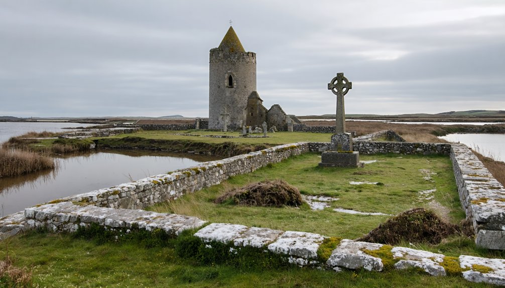
The windswept waters of the Shannon Estuary cradle Scattery Island (Inis Cathaigh), where Saint Senan established one of Ireland’s most austere monastic settlements between 488-544 AD.
Named “The Old” for his childhood wisdom, Senan banished the mythical sea serpent Cathagh and enforced extreme monastic practices—forbidding women from landing altogether. His historical significance extends through tutoring Ciarán of Clonmacnoise and establishing churches across Ireland, Cornwall, and France.
Evidence of Senan’s Legacy:
- Round Tower and 12th-century church ruins mark the sacred enclosure
- St Senan’s Well, miraculously sprung from his staff during drought
- Lady’s Grave at low water, where he controversially buried St. Cannara
- Viking raids from 795 AD through Norman dissolution in 1189
This spiritual fortress became Ireland’s most plundered settlement before complete abandonment.
Innisfallen Island: The Abbey Home of Finian Lobhar
While Viking longships terrorized Scattery Island’s exposed position on the Shannon Estuary, Saint Finian Lobhar established his monastery around 540 AD in the sheltered waters of Lough Leane—the Lake of Learning—in County Kerry.
You’ll find Innisfallen’s historical significance embedded in the Annals of Innisfallen, chronicling early Irish history from this isolated monastic community.
Finian, a disciple of Saint Columba, enforced strict vegetarian discipline among his monks while they engaged in manuscript production and scholarly pursuits.
The leper-saint—who contracted his affliction while healing a boy—built a basilica where miracles reportedly occurred long after his death in 560 AD.
Today’s abbey ruins stand as archival evidence of monastic life that preserved Ireland’s cultural legacy through centuries of autonomous spiritual dedication.
Inishtrahull, County Donegal: Ireland’s Most Northerly Abandoned Island
Six miles beyond Malin Head’s windswept cliffs, Inishtrahull—Inis Trá Tholl, “island of the hollow beach”—rises from the Atlantic as Ireland’s most northerly outpost, a mile-long plateau flanked by rocky pinnacles that once supported eighty souls and now hosts only twice-yearly maintenance visits.
Inis Trá Tholl history reveals a self-sufficient community that thrived until overfishing devastated stocks. By 1929, authorities evacuated remaining families, though lighthouse keepers maintained their vigil until automation arrived in 1987.
Lighthouse keeper stories include centenarian Barney Biddy James signaling ships with semaphore flags while younger keepers watched emigrants’ final glimpses of Ireland fade into horizon.
- Stone cottage ruins scatter across the central plateau alongside a schoolhouse and graveyard
- Fishermen once rowed turbot catches to Scottish-bound steamers
- Lloyd’s of London owned the strategic navigational point
- The 1958 lighthouse replaced its 1813 predecessor
Frequently Asked Questions
Are Ghost Towns in Ireland Safe to Visit Alone?
You’ll find over 100 abandoned Irish sites accessible for solo exploration, though you should follow essential safety tips: inform someone of your plans, wear sturdy boots on rugged terrain, and respect structural integrity warnings at crumbling medieval ruins.
Can You Stay Overnight at Any Irish Ghost Towns?
You can’t stay overnight at Irish ghost towns, as they lack abandoned accommodations converted for lodging. These preserved ruins don’t offer overnight experiences, but nearby castles like Ballyseede provide haunted alternatives for your exploration freedom.
What Caused Most Irish Villages to Become Abandoned?
You’ll find Ireland’s Exodus paralleled the Great Famine’s devastation—starvation, disease, and landlord evictions drove mass population migration from 1845-1852. Economic decline continued through isolation, lack of infrastructure, and opportunities abroad, ultimately emptying entire communities seeking liberty elsewhere.
Do You Need Permission to Explore Ireland’s Ghost Towns?
Yes, you’ll need permission before exploring Ireland’s ghost towns. General advice mandates respecting property rights and local regulations. Following proper exploration etiquette protects you legally while honoring constitutional property protections that remain despite abandonment.
Are There Guided Tours Available for Irish Ghost Towns?
Yes, you’ll find guided tours available, though 98% focus on Dublin’s historical significance rather than abandoned settlements. Most operators emphasize local legends and paranormal activity instead of authentic ghost towns, offering freedom to explore Ireland’s darker heritage independently.
References
- https://www.ireland.com/en-us/magazine/built-heritage/5-haunting-ghost-towns-in-ireland/
- https://en.wikipedia.org/wiki/List_of_ghost_towns_by_country
- https://www.autoglass.ie/13-of-irelands-most-haunted-sites/
- https://www.wildernessireland.com/blog/spooky-sites-ireland/
- https://www.atlasobscura.com/things-to-do/ireland/abandoned
- https://www.loveexploring.com/galleries/322831/abandoned-ireland-eerie-images-of-places-frozen-in-time
- https://www.tripadvisor.com/Attractions-g186591-Activities-c47-t14-Ireland.html
- https://craigconsidinetcd.com/2014/07/16/port-an-abandoned-irish-famine-village-in-donegal/
- https://arasbnb.com/port-donegal/
- https://cassidys.ca/history/pages/irish_roots/the_port.html


