You’ll discover five fascinating ghost towns within three hours of Melbourne’s CBD, each telling distinct stories of Victoria’s gold rush era. Tarnagulla and Llanelly housed over 5,000 miners who extracted thousands of kilograms from rich reefs. Talbot once boasted 30,000 residents before decline. Whroo’s Balaclava Mine features 125-meter-deep cuts you can explore, while Eldorado supported sixteen pubs at its 1850s peak. Cambarville represents a different legacy—a 1940s timber town now returned to forest. These preserved sites offer walking tracks, camping facilities, and weathered structures that reveal Victoria’s transformative nineteenth-century mining culture.
Key Takeaways
- Talbot, once home to 30,000 residents, now features Victoria’s oldest post office and preserved 1860s buildings from gold rush era.
- Llanelly and Tarnagulla emerged from 1852 gold discoveries, hosting over 5,000 miners including 1,000 Chinese workers at their peak.
- Whroo Historic Area preserves Balaclava Mine’s 125-meter-deep open cuts and timber-propped fissures, accessible via walking tracks since 1983.
- Eldorado supported 6,000 diggers, four newspapers, and sixteen pubs during its peak, with mining continuing until 1954.
- Cambarville, established in the 1940s for timber salvage, features logging cuts and weathered huts accessible by circuit walk.
Llanelly and Tarnagulla: Central Victoria’s Welsh-Named Gold Rush Twins
When alluvial gold was discovered at Sandy Creek in 1852, the remote Tarnagulla station—established just a decade earlier—transformed overnight into one of Victoria’s most significant goldfields.
You’ll find Tarnagulla history marked by extraordinary finds: the Nuggetty Gully yielded 39 kg in just fourteen days during 1853. The legendary Poverty Reef, discovered in 1854, produced 11,197 kg from its Bonanza Shoot between 1853-1866.
Nearby Llanelly mining began in 1856 when prospectors struck gold at Hard Hills rise. Together with Waanyarra, these Welsh-named settlements produced 17,400 kg of recorded gold.
Over 5,000 miners—including 1,000 Chinese residents plus Greek and Italian fortune-seekers—built thriving communities around company mines. Recognition of gold-bearing quartz reefs led to underground mining in the mid-1850s. By 1865, the settlement had transitioned from canvas structures to brick and stone buildings, reflecting the permanence and prosperity of the goldfield.
Today, geological surveys continue identifying exploration potential along the historic Poverty-line-of-reef.
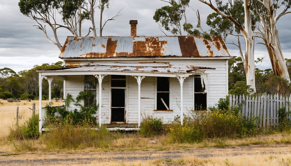
Talbot and Stony Creek: From 30,000 Souls to Scattered Ruins
Within months of gold’s discovery at Daisy Hill Creek in 1852, the settlement that would become Talbot exploded from untouched bushland into one of Victoria’s most frenzied goldfields.
You’ll find Talbot history reveals a staggering peak of 30,000 residents crowding 100 hotels and shanties during the 1850s-1860s boom. Norwegian and Swedish miners discovered the Scandinavian Lead in 1859, shaping the town’s distinctive Crescent street layout.
Meanwhile, 8 kilometers away, Stony Creek ruins mark where another community thrived until its school closed in 1916.
Stony Creek’s abandoned schoolhouse stands as a haunting reminder of once-vibrant communities that vanished with the gold.
Today, you can explore Victoria’s oldest functioning post office and preserved 1860s-1870s buildings among Talbot’s 450 remaining residents.
The courthouse, churches, and monthly farmers’ market demonstrate how freedom-loving communities preserve their independent heritage despite inevitable decline. The area’s indigenous heritage includes a 700-year-old red river gum known as the Aboriginal Shelter Tree, standing as a testament to the Dja Dja Wurrung people who inhabited this land for thousands of years before European settlement. The goldfields region produced over 60 million ounces of gold between 1851 and 1896, a legacy that shaped Victoria’s prosperity.
Whroo Historic Area: Bushwalking Through Balaclava Mine’s Legacy
On 25 October 1854, sailors-turned-prospectors John Thomas Lewis and James Meek Nickinson discovered a gold nugget atop Whroo’s highest hill, coinciding with news of the Battle of Balaklava during the Crimean War—a synchronicity that gave the Balaclava Mine its name.
Their partnership employed 100 men and netted £15,000 in first-year profits, establishing Waranga’s richest mining operation.
By 1859, just five years after the mine’s founding, the Balaclava Hill Quartz Mining Co. was generating only £6,000 annually—a significant decline from its initial success.
Today’s Balaclava tours let you explore Whroo history through preserved workings:
- Descend 125-meter-deep open cuts via refurbished 1860s tunnels
- Examine grey mullock heaps from 85,804 tons of crushed quartz
- Walk timber-propped fissures where miners extracted 21,340 ounces
Located 7 km south of Rushworth on Taungurung land, the 1983-established Historic Reserve offers walking tracks, information signs, and campgrounds. The Whroo Miners Retreat kiosk provides light refreshments and souvenirs on weekends and public holidays.
You can still prospect here—the freedom to seek gold remains.
Eldorado Historic Area: Chasing the Golden Legend in Ovens Valley
While Whroo’s miners chiseled their fortune from quartz reefs, a different breed of prospector in Victoria’s northeast pursued gold beneath the waters of Reedy Creek.
You’ll find Eldorado’s origins predate its gold boom—William Fury Baker named his 47,300-acre pastoral run “Eldorado” in 1839, long before the 1854 strike brought 6,000 diggers to these valleys.
The Eldorado mining syndicates revolutionized extraction methods, employing sluicing and deep shafts when individual panning failed.
Between 1868-1876, this settlement sprawled larger than Wangaratta, supporting four newspapers, sixteen public houses, and Cornish families who built Methodist churches.
Cock’s massive 2,000-ton dredge operated until 1954, leaving Monument Hill and architectural remnants you’ll explore today.
The gemstone-rich creek bed yielded sapphires, topaz, and gold for those famous seven-ounce horseshoes.
Baker’s prophetic naming proved remarkably prescient when gold was discovered in 1852, just a decade after he christened his pastoral property with the legendary name of a fictitious gold-rich country.
The township sits 20 km east of Wangaratta, where hilly, forested country meets the agricultural lands that now surround the historic mining works.
Cambarville: A Timber Town Tale in the Yarra Ranges
Deep in the Yarra Ranges National Park, Cambarville emerged from catastrophe when timber mill owners A Cameron and FJ Barton established their operation during the 1940s to salvage valuable timber left by the devastating 1939 bushfires.
This electricity-free settlement thrived until boom-bust cycles forced abandonment, leaving behind authentic timber heritage for you to explore.
Today’s circuit walk reveals:
- Deep cuts scarring ancient tree trunks from logging operations
- Weathered miller’s huts and saw-milling equipment among the undergrowth
- The stone Big Culvert tunnel and cascading Cora Lyn Falls
Your journey here intersects with natural conservation history—this site witnessed the 1961 Leadbeater’s possum rediscovery, confirming survival of Victoria’s faunal emblem after 52 years presumed extinct.
Located two and a half hours from Melbourne, you’ll find freedom wandering among mainland Australia’s tallest mountain ash trees. The surrounding temperate rainforest creates an atmospheric backdrop as you explore the remnants of this forgotten timber town. Among the decaying structures, you can still find houses and sawmilling equipment that once defined daily life in this remote logging community.
Frequently Asked Questions
Are Ghost Towns Near Melbourne Safe to Visit With Children?
Like exploring a forgotten attic, you’ll find ghost town activities near Melbourne offer supervised child safety at designated sites like Steiglitz’s picnic areas, though you should avoid unsupervised mine shafts and unstable structures throughout these historic locations.
abandoned towns around Mammoth Cave reveal the rich history of the area’s past settlers and their struggles. Visitors can take guided tours that uncover stories of those who once called these towns home. Additionally, the captivating landscapes surrounding the cave enhance the experience, offering stunning views and opportunities for wildlife observation.
What Supplies Should I Bring When Exploring Abandoned Gold Rush Towns?
You’ll need sturdy exploration gear including water, sun protection, first-aid supplies, and cameras to document the historical significance. Bring maps, wear closed shoes, and pack snacks since these remote community sites lack amenities.
Can I Camp Overnight at These Historic Ghost Town Sites?
You’ll find camping regulations vary by site—Steiglitz and Howqua Hills welcome overnight stays with proper facilities, while most other goldfields ghost towns don’t offer camping. Research overnight safety requirements and Parks Victoria guidelines before venturing out.
Do I Need Permits to Explore Abandoned Buildings in Victoria?
You don’t need permits for general exploration, though 540 Victorian sites lack rehabilitation bonds. However, exploration regulations don’t specifically address abandoned buildings, and you should respect historical significance while traversing Victoria’s uncoordinated abandoned site management system.
Which Ghost Towns Are Wheelchair or Mobility-Aid Accessible?
Steiglitz Historic Park offers wheelchair accessibility through its TrailRider all-terrain wheelchair (book via Lerderderg Library). Melbourne Ghost Tours feature flat, accessible paths with mobility aid-friendly design. Old Tailem Town has uneven surfaces requiring extra caution.
References
- https://www.australiantraveller.com/vic/ghost-towns-in-victoria/
- https://hemamaps.com/blogs/iconic-destinations/ghost-towns-of-the-goldfields
- https://www.theurbanlist.com/melbourne/a-list/ghost-towns-victoria
- https://ariverofroses.com/abandoned-ghost-towns-australia/
- https://en.wikipedia.org/wiki/Category:Ghost_towns_in_Victoria_(state)
- https://earthresources.efirst.com.au/product.asp?pID=542
- https://en.wikipedia.org/wiki/Tarnagulla
- https://www.victorianplaces.com.au/llanelly
- https://www.loddon.vic.gov.au/News/News-articles/Out-N-About-in-Tarnagulla-3-4-October
- http://www.tarnagulla.com


