You’ll find over 100 abandoned settlements scattered across Northern Ontario, remnants of logging, mining, and railway booms from the 1850s through the mid-20th century. Towns like Desaulniers, Milberta, and Balaclava emerged alongside railways and resource extraction, housing hundreds before economic decline emptied them. The Old Nipissing Road’s 77-kilometer stretch connects several ghost towns, while sites like Depot Harbour and Lost Channel preserve crumbling infrastructure—railway platforms, bunkhouses, and rusted equipment. These settlements document the region’s extraction economy and the communities that rose and fell with it.
Key Takeaways
- Old Nipissing Road connects abandoned settlements between Seguin Falls and Commanda, established by railway logging operations in the late 1800s.
- Desaulniers thrived as a francophone railway community after 1913 but declined when sawmills closed and the post office shut in 1960.
- Milberta and Balaclava were agricultural and lumber towns; catastrophic fires and sawmill closures led to their abandonment by the mid-1900s.
- Lost Channel area housed over 35 logging structures during the industrial boom; only ruins like boilers and bunkhouses remain today.
- Mining ghost towns like Cobalt and Porcupine preserve gold and silver rush heritage through abandoned headframes and equipment from boom-bust cycles.
Ghost Town Road: A Journey Through Abandoned Settlements
When the Ottawa, Arnprior and Parry Sound Railway pushed through Parry Sound District in the late 1800s, it sparked a constellation of settlements that would eventually fade into the forest, leaving behind the 77-kilometer corridor now known as the Old Nipissing Road.
You’ll traverse this ghost town exploration route between Highways 69 and 11, connecting Seguin Falls to Commanda. The railway enabled large-scale logging operations, but over-extraction decimated these forgotten settlements.
Seguin Falls itself relocated two kilometers south for the railroad, its original site holding 500 residents until the early 1930s.
Today, you’ll navigate varying terrain—wide gravel stretches shifting to narrow ruts through shadowed woods—passing abandoned cabins, weathered barns, and cemeteries that mark where pioneers once staked their claims to this unforgiving landscape. Ontario hosts over 200 ghost towns, each with its own story of rise and abandonment. In the early 1990s, the Forgotten Trails Association collaborated with Discovery Routes to designate the Old Nipissing Road as part of the Trans Canada Trail, making it one of the first sections in Ontario to join the world’s longest recreation trail.
Desaulniers: Echoes of a Railway Past
The vision of Father A.L. Desaulniers sparked this francophone settlement north of Lake Nipissing, where fertile soils promised agricultural prosperity.
A priest’s dream and rich earth drew French-speaking pioneers to the wilderness beyond Lake Nipissing’s northern shore.
You’ll find Desaulniers Road off Highway 539, seven kilometers from Field—Main Street now reduced to a country laneway.
The Desaulniers history transformed dramatically when Canadian Northern Railway arrived in 1913, establishing a station, siding, and water tower.
Railway significance brought immediate growth: trackside sawmills, two stores, a boarding house, cheese factory, church, and school materialized alongside stationmaster and section worker homes.
You could ship farming goods to distant markets overnight.
Yet the 1930s brought decline—sawmills closed, businesses relocated, farms failed.
The post office shuttered in 1960, followed by the remaining store.
Like other settlements documented in Ontario’s Ghost Town Heritage, Desaulniers exemplifies how communities rose and fell with industrial fortunes.
Today, decaying buildings mark where railway ambitions once flourished, including a weathered boarding house that stands as a reminder of busier times.
Milberta: Rise and Fall of an Agricultural Dream
While Desaulniers’s fate hinged on railway economics, Milberta’s story unfolded amid the agricultural ambitions that drew settlers to Northeastern Ontario’s scattered pockets of arable land.
Milberta origins trace to 1897, when Samuel Hogg established his sawmill in Kerns Township’s Little Claybelt. He merged “mil” from his operation with “Berta” honoring his wife Alberta, naming this rare sizable village northwest of New Liskeard.
You’ll find its location along Milberta Road demonstrates why settlers chose this fertile island amid Canadian Shield rock.
Milberta resilience faced its ultimate test in 1922’s catastrophic fire—18 townships consumed, 43 lives lost, thousands homeless. The blaze razed most structures across 1,680 square kilometers.
Despite overwhelming adversity, settlers displayed remarkable determination to rebuild their community.
Today, only Milberta United Church survives, standing with a vintage road plough as evidence to abandoned dreams. Like Cairns, which lost its post office in 1959, Milberta’s remnants remind us how quickly thriving communities can fade into history.
Balaclava: The Lumber Town Frozen in Time
Balaclava’s naming commemorated Britain’s 1854 Crimean War victory, though its founding predated this 1859 designation by several years.
You’ll find Balaclava history rooted in Eastern Ontario’s former United Townships of Carrick and Brant, where George Scott or Duncan Ferguson and Donald Cameron established a sawmill around 1850-1855.
The lumber boom transformed this settlement into a thriving industrial center, capitalizing on abundant spruce, hemlock, and white pine.
By the late 19th century, two hotels, a blacksmith shop, and Joseph Lagree’s general store served the community.
The Richards family operated the sawmill for 89 years after purchasing it in 1868.
When William Hunter sued them in 1903 for sawdust pollution—Ontario’s first environmental lawsuit—they installed the province’s first sawdust burner, still visible today.
The mill burned down in 1915 but Richards rebuilt it in 1936, continuing operations until the mill’s closure in 1959 marked the end of Balaclava’s timber prosperity.
Today, the well-preserved sawmill structure stands as one of Ontario’s creepiest buildings, appearing perpetually at risk of collapse despite surviving decades of neglect.
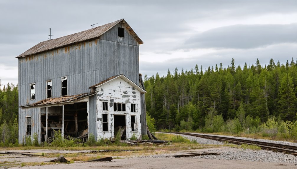
Lost Channel Area: A Cluster of Forgotten Communities
During Ontario’s last great logging boom at the turn of the 20th century, Lost Channel emerged as an essential industrial hub within the Parry Sound District’s Pickerel River system.
Connected to the Canadian Northern Railway, this forgotten community housed over 35 structures—sawmills, bunkhouses, storehouses—supporting timber operations across the Kawigamog wilderness.
You’ll find remnants of that vanished world scattered through the forest:
- A rusted steam boiler resting in the cove waters, marking where countless board-feet passed through
- Crumbling concrete pedestals where the sawmill once thundered with unconstrained industry
- The weathered bunkhouse, now surrounded by seasonal cottages instead of lumber workers
After abandonment post-WWII, Lost Channel transformed from extraction site to recreation gateway.
The 1970s brought cottage developers and RV sites, replacing industrial ambition with wilderness freedom—a rebirth these forgotten communities never anticipated. Unlike Ontario’s Lost Villages near Cornwall, where approximately 6,500 people were displaced by a deliberate flooding project, Lost Channel’s abandonment came gradually through economic decline.
The settlement’s industrial origins trace back to 1914 when Lauder, Spears and Howland established the first sawmill, shipping lumber along a rough tote road to the Mowat railway siding before constructing the Key Valley Railway.
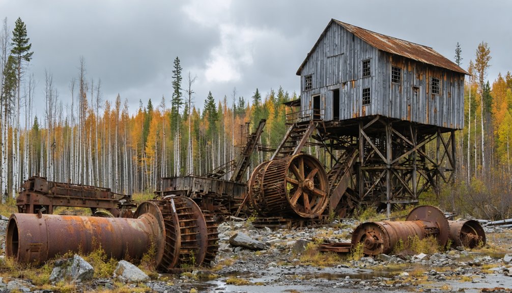
Mining Ghost Towns of the Sudbury Region
The forest-driven economy of Lost Channel represented just one industrial trajectory through Ontario’s north—mineral extraction carved an entirely different pattern of settlement and abandonment across the Sudbury Basin.
You’ll find remnants of single-industry towns like Creighton, where the Canadian Copper Company established operations in 1900, and Ramsey, which housed mining families from 1937 until ore depletion forced closure in 1944.
These settlements demonstrated remarkable community resilience despite challenging conditions—deep forest isolation, company-controlled infrastructure, and economic vulnerability tied to mineral deposits.
Today’s mining heritage sites include Chelmsford Sawmill, Frood Open Pit Mine, and Cobalt’s Heritage Silver Trail, where rusting headframes and abandoned adits document an extraction economy that shaped regional development for nearly a century before ore exhaustion scattered these communities to wind and wilderness.
Railway Relics and Depot Remnants
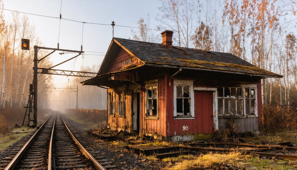
You’ll find Northern Ontario’s railway ghost towns preserve the skeletal infrastructure of an industrial transportation era that shaped settlement patterns from the 1880s through the early twentieth century.
At sites like Desaulniers, where Canadian Northern Railway established operations in 1913, abandoned station platforms and sidings mark locations where agricultural commodities once moved from remote farms to distant markets.
Depot Harbour exemplifies the most dramatic railway relic—a complete transportation hub built on expropriated Anishinaabe land, featuring massive sheds, turntable rotundas, and the foundations of timber-frame grain elevators that CNR abandoned in favor of South Parry operations.
Abandoned Railway Station Architecture
When you explore Northern Ontario’s ghost towns, railway station architecture serves as the most enduring physical evidence of communities that once thrived along now-abandoned rail corridors.
The region’s railway heritage manifests in structures like Drocourt’s station, now accessible only by ATV trail, and the repurposed Canadian Northern Railway depot in Port Hope.
Nearly 2,000 documented station views reveal systematic post-WWII alterations and 1960s demolitions across northern districts.
The abandoned architecture tells stories of communities you’ll no longer find on maps:
- Fraserdale’s terminus served Abitibi Canyon workers from 1923-1928 before the line pushed north
- Stations in Algoma and Cochrane Districts mark the Algoma Central Railway’s 1899-1995 operations
- Documented buildings across Simcoe and Haldimand-Norfolk counties show successive architectural changes from multiple angles
Desaulniers Rail-Side Decline
Along Highway 539’s gravel margins, approximately seven kilometers from Field, Desaulniers’ railway relics mark where Canadian Northern Railway infrastructure once catalyzed a Francophone settlement‘s brief prosperity.
The 1913 station and siding transformed Father A.L. Desaulniers’ agricultural vision into commercial reality—trackside sawmills, cheese factories, boarding houses, and dual stores emerged virtually overnight.
Railway impact proved paradoxical: while enabling farmers to ship goods to distant markets, the infrastructure couldn’t compensate for soil fertility promises that never materialized.
Desaulniers decline accelerated systematically—sawmill closure preceded the 1930s downturn, businesses relocated by 1960, and weathered buildings collapsed into overgrown foundations.
You’ll find haunting remnants accessible via Highway 64 northbound, testifying how transportation networks create communities that market forces ultimately abandon.
Depot Harbour Transportation Hub
Evidence of abandonment marks the landscape:
- Rose Point Bridge stands skeletal against the sky, tracks long lifted since the early 1960s.
- Station foundations crumble where grain elevators burned in 1959, residential buildings erased by August’s end.
- Wharf pilings remain from iron ore operations that persisted until the 1980s, automated but ultimately doomed.
You’re witnessing infrastructure sacrificed when centralized control prioritized efficiency over community survival.
Gold Rush Legacies and Resource Extraction Sites
Northern Ontario’s resource extraction sites transformed from speculative dreams into boom-and-bust cycles that left physical and cultural imprints across the Canadian Shield.
You’ll find the Porcupine Gold Rush of 1909-1911 staked 8,000 claims once the railway reached Golden City, requiring industrial-scale operations unlike earlier placer methods.
The Cobalt Silver Rush, sparked by Darragh and McKinley’s 1903 discovery, survived two devastating fires before closing in the 1930s.
Eldorado’s 1866 rush demonstrated how quickly fortunes could evaporate—Marcus Powell’s gold-dripping cave attracted California miners, yet professional assessments proved worthless by 1868.
These resource extraction ventures, alongside Kirkland Lake and Arden, filled Northern Ontario with prospectors whose abandoned headframes, adits, and equipment now mark freedom-seeking endeavors that reshaped the wilderness.
Frequently Asked Questions
Are Ghost Towns in Northern Ontario Safe to Visit Alone?
Solo exploration isn’t recommended due to structural hazards, wildlife encounters, and extreme isolation without cell service. You’ll need rigorous safety precautions: inform others of plans, carry emergency supplies, and assess each site’s specific risks before venturing alone.
Do You Need Permission to Explore Abandoned Buildings in Ghost Towns?
Yes, you’ll need permission for private land explorations, despite absent barriers suggesting otherwise. Legal considerations require verifying ownership through municipal records, while exploration etiquette demands respecting posted boundaries and contacting landowners beforehand.
What Is the Best Season to Visit Northern Ontario Ghost Towns?
While winter’s romance tempts, summer’s your best time for accessible roads and open heritage sites. You’ll explore seasonal attractions like Cobalt’s Silver Trail freely, with ideal conditions reaching remote ruins before autumn’s closures.
Can You Camp Overnight Near These Ghost Town Locations?
You’ll find camping opportunities near most sites through provincial park zones at Kiosk, crown land permits around Milberta and Desaulniers, and primitive roadside spots along colonization roads—always verify current camping regulations and prioritize overnight safety.
Are There Guided Tours Available for Northern Ontario Ghost Towns?
You won’t find formal guided tour options for Northern Ontario ghost towns—they’re preserved through self-guided exploration. Algoma’s ATV tours highlight historical significance of abandoned mines, while Northeastern Ontario promotes independent road trips honoring these vanished settlements.
For those seeking a similar experience, ghost towns near Melbourne offer a unique glimpse into the past. Visitors can wander through the remnants of former gold rush communities and explore the stories behind these lost places. Each site reveals a chapter of history that contributes to the rich tapestry of Australia’s heritage.
References
- https://www.ghosttowns.com/canada/ontario/ontario.html
- https://northernontario.travel/northeastern-ontario/ghost-towns-northeastern-ontario
- https://www.readersdigest.ca/travel/canada/balaclava-ghost-town-ontario/
- https://northernontario.travel/atving/atving-through-ontario-ghost-towns
- https://curiocity.com/ghost-towns-ontario/
- https://www.youtube.com/watch?v=q0kIKlKw1k0
- https://en.wikipedia.org/wiki/Category:Ghost_towns_in_Northern_Ontario
- https://discoveryroutes.ca/old-nipissing-ghost-trail/
- https://www.youtube.com/watch?v=HffonbM1tVM
- https://northernontario.travel/atving/ghost-towns-old-nipissing-road-atv-mission-part-1-first-attempt


