You’ll find the Oklahoma Panhandle’s ghost towns scattered across what was once No Man’s Land, a lawless corridor where settlements like Beer City thrived on bootlegging before statehood enforcement arrived. Cloud Chief collapsed after losing its county seat status in 1906, while Texola withered when Interstate 40 bypassed Route 66 in the 1970s, dropping its population by 94%. The Dust Bowl accelerated abandonment across the region, leaving behind structures, cemeteries, and stories that reveal how jurisdictional voids, environmental disaster, and highway rerouting transformed thriving communities into weathered remnants awaiting your exploration.
Key Takeaways
- The Oklahoma Panhandle’s jurisdictional void (1850-1890) fostered lawlessness, bootlegging, and settlements that eventually became ghost towns.
- Beer City operated as an unregulated whiskey depot where vigilante justice prevailed in the absence of formal law enforcement.
- Cloud Chief declined after losing county seat status to Cordell in 1906, transforming from 3,000-4,000 residents to abandoned farmland.
- Texola’s population plummeted 94% after Interstate 40 bypassed Route 66, leaving deteriorating banks, cotton gins, and historic service stations.
- Preservation efforts include the No Man’s Land Museum and historic sites like Texola’s 1910 jail and Kenton’s operational post office.
Beer City: The Lawless Booze Haven of No Man’s Land
Because the federal government never surveyed the Public Land Strip until 1891, a peculiar vacuum of law emerged in what settlers called “No Man’s Land”—a 34-mile-wide corridor stretching across the Oklahoma Panhandle.
Beer City thrived in this void near Beaver Creek’s trail crossing, functioning as an unregulated whiskey depot for cattlemen and homesteaders. The settlement’s saloon culture defined daily life, with road ranches combining stores, drinking establishments, and campgrounds serving northern cattle drives.
In lawless No Man’s Land, Beer City’s road ranches served whiskey and chaos to cattlemen along the trail crossing.
Without formal jurisdiction, claim jumpers and horse thieves operated brazenly—Rockhold shot opponents over land disputes, while Williams fired at settlers for entertainment. This chaos sparked vigilante justice: committees burned offending saloons, hanged distillery robbers after public bragging, and surrounded Rockhold’s soddy with kerosene-soaked rags. Settlers also confronted road-trotters—con men who drifted through the territory exploiting the absence of law enforcement. The cattlemen who established ranches in the region after the Civil War created their own self-governing rules to manage their operations and disputes, establishing the foundations for Cimarron Territory in 1886.
For over five years, improvised local boards maintained order through swift, often brutal enforcement.
Sod Town: A Settlement Lost to the Plains
Where Beer City capitalized on lawlessness through liquor sales, Sod Town emerged as the first settlement in eastern No Man’s Land built entirely from the land itself—blue creek sod cut from wet soil and stacked into roughly a dozen structures standing irregularly across the naked prairie.
Sod construction techniques created dark, foul-smelling interiors where refuse littered the spaces between unpainted doorways. Community dynamics centered around two saloons, a general store, and a blacksmith shop, attracting the notorious Chitwood Gang of horse thieves.
Older schoolchildren hung six-shooters on classroom walls while moonshine flowed illegally into Cherokee Strip. Vigilante justice eventually hanged most gang members, but poverty had already consumed the settlement. Despite the hardship, thieves showed respect to kind neighbors by not stealing from them. The settlement has passed into oblivion, with years of cultivation erasing most signs from the land.
Today, only ridge lines mark where buildings once stood at N36° 32.198′ W100° 14.116′—wind replacing what freedom wrought.
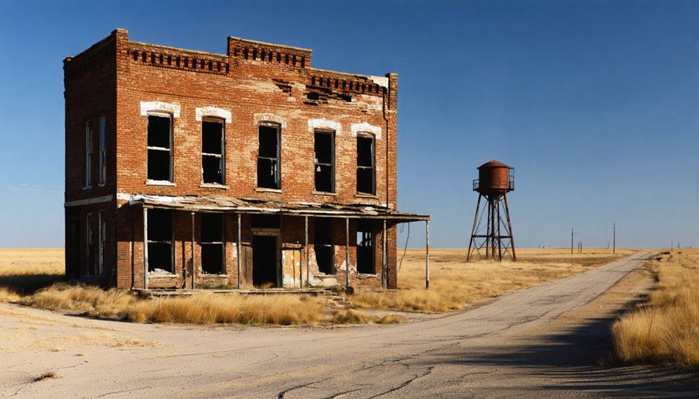
Route 66’s Fading Memory: The Decline of Texola
When Interstate 40 bypassed Texola’s Route 66 alignment, the town’s lifeline severed—motorists who’d once stopped at the Magnolia Service Station and three hotels now sped past on the new highway.
You’ll find the town’s 1930 peak population of 581 dwindled to just 43 residents, leaving behind deteriorating structures that once housed banks, cotton gins, and the Texola Herald’s printing press.
The westernmost Oklahoma town on Route 66 now stands as a semi-abandoned monument to how highway rerouting transforms thriving border communities into architectural relics.
Among the surviving landmarks, the 1910 Texola Jail remains standing with its distinctive iron bars on doors and windows, a testament to the town’s more prosperous era. The Magnolia Service Station, despite its listing on the National Register of Historic Places, continues to deteriorate without intervention.
Iconic Architecture Remains Standing
The Magnolia Service Station stands as Texola’s most recognizable landmark, its weathered frame anchoring the precise point where Route 66’s divided highway converges at the intersection of Grand Avenue and Broadway.
Listed on the National Register of Historic Places in 1995, this abandoned relic now teeters on collapse, its architectural significance fading with each passing season.
You’ll find the 1910 Territorial Jail on the town’s west side, a one-cell structure that’s become the primary tourist attraction despite its modest size.
The jail features a small display about infamous outlaws including Belle Star, Billy the Kid, Jesse James, and Black Bart, though none were ever actually incarcerated there.
Along Grand Avenue, the skeletal remains of gas stations, hotels, and restaurants tell stories that 1905 fire maps once documented—grocers, meat markets, a post office.
Empty buildings with old trucks out front dot the landscape, their deteriorating facades serving as monuments to commerce that once thrived along this legendary highway.
The Tumbleweed Grill, operating from the 1930s Water Hole No. 2 building, represents rare successful historic preservation, its interior trim salvaged from neighboring ruins.
Highway Rerouting Sealed Fate
Route 66’s arrival in 1926 transformed Texola into a thriving waypoint, swelling its population to 581 by 1930 as motorists streamed through town seeking fuel, food, and lodging.
You’ll find this prosperity documented in archival records showing multiple gas stations, three hotels, and bustling restaurants serving cross-country travelers.
But Texola History reveals a harsh turning point: Interstate 40’s completion in the early 1970s bypassed the town entirely, severing its economic lifeline.
Traffic evaporated overnight, leaving stretches of old Route 66 abandoned.
By 2010, only 36 residents remained—a 94% decline from the peak years.
The town’s origins trace back to the Choctaw Oklahoma and Gulf Railroad, which established operations in 1902 and laid the foundation for Texola’s initial growth as a farming community.
Located on the Texas-Oklahoma border, Texola’s name evolved through several iterations from Texokla to Texoma before settling on its current form in 1901.
Despite hopes for Economic Revival through heritage tourism, the Magnolia Service Station deteriorated into ruins, symbolizing how federal highway decisions crushed small-town independence.
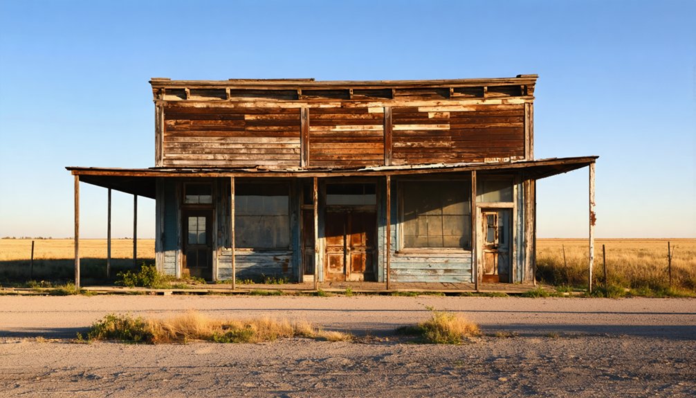
Semi-Abandoned Structures Today
Crumbling facades and empty window frames greet visitors along Texola’s stretch of old Route 66, now renamed Grand Avenue, where remnants of mid-century commerce slowly surrender to the elements.
You’ll discover semi abandoned landmarks throughout this near-ghost town, including the deteriorating Magnolia Service Station at Grand Avenue and Broadway—listed on the National Register of Historic Places despite its collapsing garage bays.
The one-room stone jail from 1910 stands as Texola’s most intact attraction, offering tangible historical significance for those seeking authentic roadside heritage.
On the western edge, an old bar’s weathered sign declares: “There’s no other place like this place anywhere near this place so this must be the place.”
These structures provide unregulated exploration opportunities before they’re lost forever.
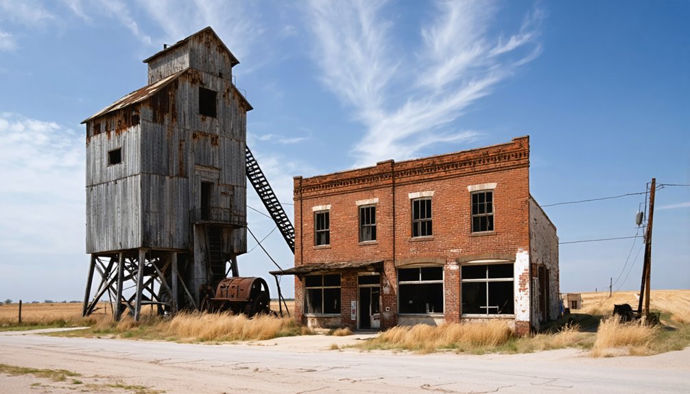
Cloud Chief: From County Seat to Forgotten Farmland

If you’d been among the thousands racing for townsite claims during the 1892 Cheyenne-Arapaho land run, you’d have witnessed Cloud Chief—originally called Tacola—transform from designated H County seat to tent city within two hours.
The county’s warped cottonwood courthouse housed sheriff, judge, clerk, and superintendent in a single 20×30 foot room, serving a population that plummeted from over 3,000 to just a few hundred within months.
Without railroad access and relying on irregular stage lines from El Reno or Minco, Cloud Chief couldn’t sustain its brief authority as merchants struck their tents and claim-stakers abandoned the settlement during the six-month grace period.
Tacola’s 1892 Land Run
On April 19, 1892, thousands of settlers lined up along the boundary of the Cheyenne-Arapaho Opening, waiting for the noon gunshot that would release 4,300,000 acres for settlement.
You’d have witnessed Tacola emerge from empty prairie to a town of 3,000-4,000 residents within 24 hours, designated as County H’s seat that same day.
Tacola’s growth defied the region’s cattle-ranching designation. German and Russian immigrants from Kansas transformed the settlement, establishing Mennonite churches and German-language newspapers.
This ethnic diversity shaped the community’s character as you’d find culturally specific enterprises serving these populations.
The town soon became Cloud Chief, housing Washita County’s first courthouse.
While 25,000 settlers claimed land across six counties that day, few settlements matched this explosive beginning that would ultimately fade into forgotten farmland.
H County Seat Decline
Within eight years of Tacola’s dramatic founding, Cloud Chief’s residents found themselves voting away their town’s future. On August 7, 1900, citizens chose Cordell’s central location over their own community’s historical significance as Washita County’s seat.
You’ll find this decision sparked immediate legal battles. The Oklahoma Territorial Supreme Court ruled in 1904 that moving the seat required federal authorization, temporarily breathing life into Cloud Chief’s hopes.
However, congressional lobbying by Cordell attorney Sam Massingale sealed the town’s fate in 1906.
The 1907 Oklahoma constitution confirmed Cordell permanently, devastating Cloud Chief’s community impact.
Today, you’ll discover only decaying structures and historical markers where Oklahoma’s territorial courthouse once stood—a ghost town swallowed by farmland.
Transportation Failures and Abandonment
After Congress sealed Cloud Chief’s administrative death sentence in 1906, the town desperately needed alternative economic foundations to survive.
Transportation challenges proved insurmountable. Unlike Cordell, which secured vital rail connections, Cloud Chief remained isolated from major freight and passenger lines. The economic shifts accompanying Oklahoma’s statehood in 1907 favored towns with railroad access, leaving Cloud Chief stranded in agricultural backwaters.
Critical infrastructure failures that doomed Cloud Chief:
- No railroad company extended tracks through the town, eliminating commercial freight opportunities
- Limited road development prevented reliable year-round access to regional markets
- Neighboring communities with superior transportation links absorbed Cloud Chief’s remaining businesses
Without county government or transportation infrastructure, you’d find no reason to settle there. Residents departed for towns offering genuine economic prospects, transforming Cloud Chief into abandoned farmland.
Why the Oklahoma Panhandle Became a Ghost Town Graveyard
Between 1850 and 1890, the Oklahoma Panhandle existed in a jurisdictional void that transformed it into one of America’s most lawless territories.
You’ll find this lawlessness legacy created conditions perfect for ghost towns to emerge and fade.
The region’s bootlegging history centered in places like Beer City, where alcohol flowed freely while neighboring Kansas and Texas enforced Prohibition.
Bootleggers buried profits, disappeared mysteriously, and left behind structures that now stand empty.
Beneath Oklahoma’s dust lie bootleggers’ buried fortunes, their owners vanished without trace, leaving only skeletal buildings as monuments.
Then came the Dust Bowl.
You’d watch prairie grass destruction lead to relentless wind erosion, choking dust storms, and agricultural collapse.
Farmers abandoned desiccated fields as topsoil blasted away.
Oklahoma’s statehood ended the jurisdictional vacuum, bringing law enforcement that dismantled illegal operations.
Combined with environmental devastation, these forces created the Panhandle’s ghost town graveyard.
What Remains: Visiting Panhandle Ghost Town Sites Today
Across the Oklahoma Panhandle‘s windswept grasslands, you’ll encounter physical remnants of communities that thrived during territorial days and the homesteading era. Ghost town architecture persists in varied states—from Kenton’s functioning Baptist Church to Texola’s Route 66 commercial buildings.
You’ll find log cabin remnants documenting pioneer settlement patterns and scattered abandoned houses across former townsites.
What You Can Still Explore:
- Kenton’s post office serves just 17 residents, maintaining community resilience despite extreme depopulation
- Cemetery sites like Moral’s wooded burial grounds preserve cultural heritage
- Route 66 structures in Texola showcase mid-20th century design
Private ownership restricts access to some locations, including Beer City’s farmland conversion.
Road conditions generally accommodate vehicle exploration, though lake submersion eliminated sites like Woodville beneath Lake Texoma.
Agricultural reuse dominates most former townsites.
Preserving the Stories of Oklahoma’s Vanished Communities
While physical structures crumble into the prairie soil, documented memories and archival records form the backbone of preserving Oklahoma’s ghost town heritage.
You’ll find invaluable resources at the No Man’s Land Museum in Goodwell, founded in 1934, where exhibits chronicle the Panhandle’s economic and ecological history. The Oklahoma Historic Preservation Office maintains essential records of cultural resources, while archaeological investigations document homesteads from the late nineteenth to mid-twentieth centuries.
These preservation efforts protect community heritage without government overreach. You can access newspaper articles detailing Dust Bowl experiences and archaeological context studies that evaluate twentieth-century sites.
Frequently Asked Questions
Were Any Famous Outlaws Specifically Associated With Beer City During Its Heyday?
No nationally famous outlaws were specifically tied to Beer City during its heyday. You’ll find local badmen dominated the scene, managing saloons like the White Elephant, but their Outlaw Influence remained regional rather than legendary.
What Materials Were Used to Construct the Sod Houses in Sod Town?
You’d find absolutely everything from the prairie itself! Sod construction relied on thick grass blocks cut from native ground, while building materials included scarce timber for roof support, tar paper, brush, canvas, and plaster for finishing touches.
Are There Any Guided Tours Available for Oklahoma Panhandle Ghost Towns?
No guided tours exist for Panhandle ghost towns—you’ll need to explore independently. Self-guided visits to Texola, Kenton, and Beer City offer historical insights through preserved artifacts, museum collections, and remnants along forgotten roads you can freely traverse.
Can You Legally Metal Detect at Cloud Chief’s Remaining School Buildings?
No, you can’t legally metal detect there without permission. The school’s stone walls symbolize enduring property rights—those buildings remain privately owned. Metal detecting regulations require landowner consent, despite the site’s historical significance.
What Was Adamson’s Primary Industry Before It Became Abandoned?
Coal mining drove Adamson’s economy, with operations reaching 800 feet deep and supporting 3,500 residents until 1914’s catastrophic collapse ended its historical significance. The town’s agriculture decline followed when miners abandoned flooded shafts forever.
References
- https://mix941kmxj.com/25-texas-and-oklahoma-ghost-towns-and-the-legends-they-left/
- https://www.youtube.com/watch?v=5d-wHDTIbb0
- http://www.ou.edu/news/articles/2024/may/ou-researcher-unveils-book-of-oklahomas-ghost-towns.html
- https://pocketsights.com/tours/tour/Shamrock-Oklahoma-Ghost-Towns-Creek-Lincoln-Payne-and-Pawnee-Counties-2749
- https://www.rideok.com/ghost-towns-of-oklahoma-cloud-chief/
- https://www.okhistory.org/publications/enc/entry?entry=GH002
- https://www.historynet.com/oklahoma-panhandle-badmen-in-no-mans-land/
- https://en.wikipedia.org/wiki/Oklahoma_panhandle
- https://www.youtube.com/watch?v=LUbwVR0z0nA
- https://geographicgeoff.substack.com/p/oklahomas-strange-panhandle


