You’ll find approximately 150 ghost towns across Saskatchewan, remnants of communities that thrived during the province’s 1901-1936 population boom when wheat prosperity attracted nearly one million settlers. Economic collapse from exhausted mines, consolidated farms, and abandoned rail lines triggered widespread abandonment, leaving 12% of Saskatchewan’s land dotted with empty grain elevators and crumbling churches. Highway 13’s Ghost Town Trail connects 32 documented settlements including Forward, Scotsguard, and Maryville, where Terry Brown’s photographic documentation preserves these vanishing architectural monuments for future generations to explore.
Key Takeaways
- Saskatchewan has approximately 130-150 confirmed ghost towns, with around 12% of the province’s land considered abandoned due to economic decline.
- The Ghost Town Trail along Highway 13 connects 32 former communities over 675 miles, including Forward, Scotsguard, and Maryville.
- Economic factors like exhausted mines, railway pullouts, highway rerouting, and government service centralization drove widespread community abandonment across Saskatchewan.
- Notable ghost towns include Forward with 1,200 former residents, Scotsguard reduced to two residents, and Maryville featuring three abandoned churches.
- Explorers should bring proper equipment and paper maps, watch for structural hazards and hidden wells, and visit during fall or early spring.
What Transforms a Thriving Community Into a Ghost Town?
When a community loses its economic foundation, the transformation from bustling hub to ghost town follows a predictable pattern.
You’ll find economic factors driving this decline: exhausted mines, consolidated farms, and abandoned rail lines that once sustained prairie settlements. Community decline accelerates when grain trucks replace local elevators, highways bypass main streets, and improved roads make larger centers more accessible than your corner store.
During the Dirty Thirties, you’d witness three-quarters of populations fleeing semi-arid regions.
Natural disasters compound human decisions—droughts, fires, and dust storms finish what economic collapse started. Government centralization pulls services away, while boom-and-bust resource cycles leave single-industry towns vulnerable.
Your neighbors depart seeking opportunities elsewhere, shrinking tax bases until the snowball effect becomes irreversible. The harsh Prairie climate presents fundamental challenges for agricultural communities attempting to maintain viability. The transition from two quarter farms to multi-section operations fundamentally reshaped rural Saskatchewan’s settlement patterns.
How Many Abandoned Settlements Dot the Saskatchewan Landscape?
The scale of abandonment across Saskatchewan becomes evident through documented counts: 137 ghost towns appear on Wikipedia’s official listing, though researchers like Humboldt author Terry Brown—who drove 10,000 kilometers cataloging these sites—estimate the actual number closer to 150.
Provincial records confirm approximately 130 settlements qualify as ghost towns, with 12% of Saskatchewan’s land considered abandoned.
The Ghost Town Trail alone connects 32 former communities along 675 miles of Highway 13, from towns that peaked at 1,250 residents down to hamlets with just 60 inhabitants.
Abandonment reasons include highway rerouting, railway pullouts, and resource exhaustion—forces that triggered widespread population decline. The settlement boom that created these communities occurred during the “Last Best West” marketing campaign from 1896 to 1914, when immigration was actively encouraged to establish Canadian presence on the prairies. Brown’s documentation efforts resulted in a book featuring over 10,000 images of these abandoned settlements.
Today, many locations exist only as markers where thriving communities once stood.
The Boom Years: When Saskatchewan Ranked Third in Canadian Population
Between 1901 and 1936, Saskatchewan experienced demographic growth unmatched in its history, transforming from a sparsely settled territory of 91,000 residents into Canada’s third most populous province.
The immigration impact drove this expansion, with newcomers comprising 34.6% of the population by 1931—primarily Ukrainians, Americans, Germans, and Scandinavians seeking land ownership.
Population trends revealed Saskatchewan’s meteoric rise:
- 1891-1911: Growth of 1,124.77%, quintupling to 492,000 residents
- 1931: Nearly one million inhabitants representing 8.9% of Canada’s total
- 1936: Peak population of 931,547, surpassing all provinces except Ontario and Quebec
This wheat-fueled prosperity attracted settlers through intensive government advertising campaigns.
Rural communities proliferated across the prairies, establishing the foundation for what would become—after the Depression’s arrival—today’s abandoned settlements. By 1906, the population exceeded a quarter of a million, with 84.4% living in rural areas. Today, Saskatchewan is known for wheat fields, a legacy of this agricultural heritage that defined the province’s boom years.
Must-Visit Ghost Towns for Urban Explorers and History Enthusiasts
You’ll find exceptional exploration opportunities along Highway 13’s 675-mile corridor, where 32 documented ghost towns reveal Saskatchewan’s settlement patterns from the early 1900s.
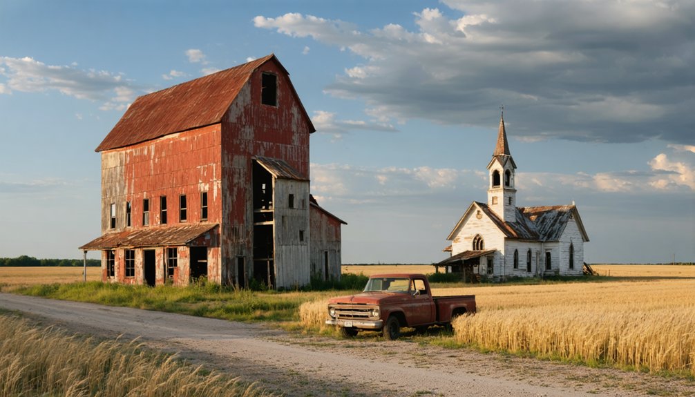
Forward, once home to 1,200 residents and marked by a commemorative cairn 43 kilometers west of Weyburn, offers visible remnants of its former infrastructure including a jail, school, and firehall.
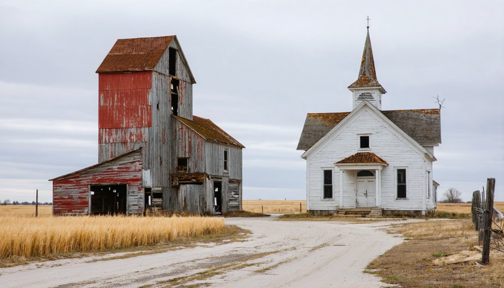
Before visiting sites like Scotsguard—reduced to two residents by 2020—or Robin Hood where the post office closed in 1971, you must prepare proper safety equipment and respect private property boundaries, as many structures bear no-trespassing designations. When photographing decaying homesteads, be cautious of hazards like open wells concealed in tall grass. Maryville stands out with three abandoned churches positioned at a single intersection, representing the town’s once-thriving religious community.
Top Ghost Town Destinations
Spanning 675 miles across southern Saskatchewan, Highway 13’s Ghost Town Trail connects 32 abandoned communities that once thrived during the province’s early settlement era.
You’ll discover ghost town legends embedded in abandoned architecture at every turn, from Forward’s remnants 43 km west of Weyburn to Scotsguard’s preserved structures northeast of Shaunavon.
as you continue your journey, exploring ghost towns near St. Louis will unveil even more tales of the past. Each site tells its own story, with crumbling buildings and forgotten streets echoing the lives that once thrived there. Whether you’re an avid urban explorer or just curious about history, these locations offer a unique glimpse into a bygone era.
Three essential stops demand your attention:
- Forward – Once home to 1,200 residents, featuring documented remains of a jail, lumberyard, and printing shop marked by a historic cairn.
- Scotsguard – Two residents maintain this site where six grain elevators once stood, now being preserved as a museum. One family owns the entire town, which also features a collection of old cars and restored buildings.
- Kayville – An off-the-beaten-path destination showcasing rustic churches and original homesteads.
Other notable ghost towns along the trail include Candiac, Frobisher, and Shackleton, each offering distinctive photographic subjects from weathered facades to vintage signage.
These sites offer unrestricted exploration through Saskatchewan’s settlement history along the historic Red Coat Trail.
Essential Exploration Safety Tips
Ghost town exploration demands awareness of documented structural hazards that Saskatchewan municipalities have catalogued through decades of building inspections and enforcement records.
Licensed building officials have issued unsafe condition orders for structures posing imminent dangers like fire risks and compromised foundations. You’ll need proper exploration equipment before entering any site—municipalities often restrict access to buildings deemed unsafe for entry after tax enforcement proceedings.
Your safety protocols must address hidden hazards beyond crumbling walls. Wells, cisterns, and septic tanks create serious liability concerns on abandoned properties.
Rural municipalities maintain responsibility for these unorganized hamlet sites, where environmental risks from improper waste disposal threaten public health. Avoid structures marked by building officials, and never enter buildings without understanding municipal nuisance bylaws governing these derelict sites.
Preserving Memory Through Photography and Documentation
You’ll find that Terry Brown’s photographic work exemplifies systematic documentation efforts, as he’s spent years capturing Saskatchewan’s vanishing architectural heritage before complete deterioration occurs.
His methodical approach extends to prairie cemetery tombstones, creating permanent visual records of burial grounds that mark former communities now lost to consolidation and depopulation.
When you examine these documentary photographs alongside building surveys, they function as archival evidence preserving structures that fire, weather, and abandonment will inevitably destroy.
Terry Brown’s Photographic Journey
Over six years of methodical exploration, Terry Brown traversed more than 10,000 kilometres of Saskatchewan’s grid roads to document the province’s vanishing settlements.
Terry’s inspiration crystallized into *Blowing in the Wind: Ghost Towns in the Saskatchewan Grid*, a thorough visual archive that captures 137 documented ghost towns through 388 coloured photographs.
His visual storytelling approach preserved settlements ranging from Romance to Sinnett, amassing over 10,000 images that chronicle:
- Architectural remnants from crumbling foundations to standing structures
- Geographic patterns explaining settlers’ location choices
- Métis heritage sites including Round Prairie and Batoche
Brown’s daughters ultimately convinced him to publish this pictorial account, transforming his extensive documentation into an accessible coffee table format that guarantees future generations can witness Saskatchewan’s settlement history before these communities disappear entirely.
Documenting Prairie Cemetery Tombstones
While Terry Brown’s lens captured the architectural skeletons of abandoned settlements, another documentary practice emerged across Saskatchewan’s rural landscape: the systematic photographing and transcription of prairie cemetery tombstones.
You’ll find over 3,300 burial sites scattered across Saskatchewan, with 1,750 documented through the Saskatchewan Cemeteries Project as of August 2017. This tombstone preservation effort combines photography with detailed transcription forms, capturing inscriptions spanning 1850-1994.
Ground-penetrating radar and drone technology locate unmarked graves—one prairie village honored 45 unknown burials through this method. Cemetery documentation requires ownership verification before volunteers begin mapping layouts, measuring monuments, and evaluating structural integrity.
The Saskatchewan Genealogical Society maintains searchable indexes, while Church of Jesus Christ of Latter-day Saints microfilm archives preserve these silent historians documenting local biographies.
Buildings Before They Disappear
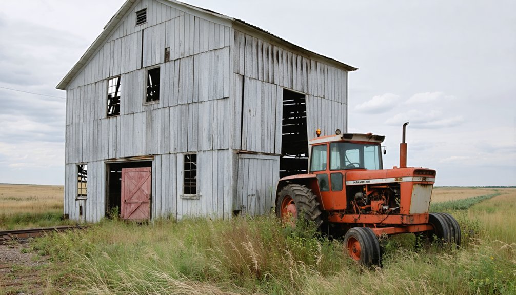
Since the 1960s, western Saskatchewan’s grain elevators have stood as sentinels of abandonment, their weathered facades still bearing the original UG and Wheat Pool logos that once signified agricultural prosperity.
You’ll find these structures alongside churches, commercial buildings, and homes that demand documentation before they vanish completely. The 1989 tornado near North Battleford displaced several buildings, while demolitions within the last decade accelerated rural decay.
Essential Documentation Targets:
- Main Street commercial corridors in towns like Blain Lake and Smut, where cafes, hardware stores, and Imperial Gas stations persist as storage facilities
- Residential structures throughout Insinger and Robsart, where toys and foundations tell family histories
- Unique survivals including Borden’s Depression-era bridge and repurposed hockey rinks
Photograph during fall or early spring when bare trees enhance the abandoned architecture’s haunting isolation.
What Remains: Grain Elevators, Churches, and Crumbling Main Streets
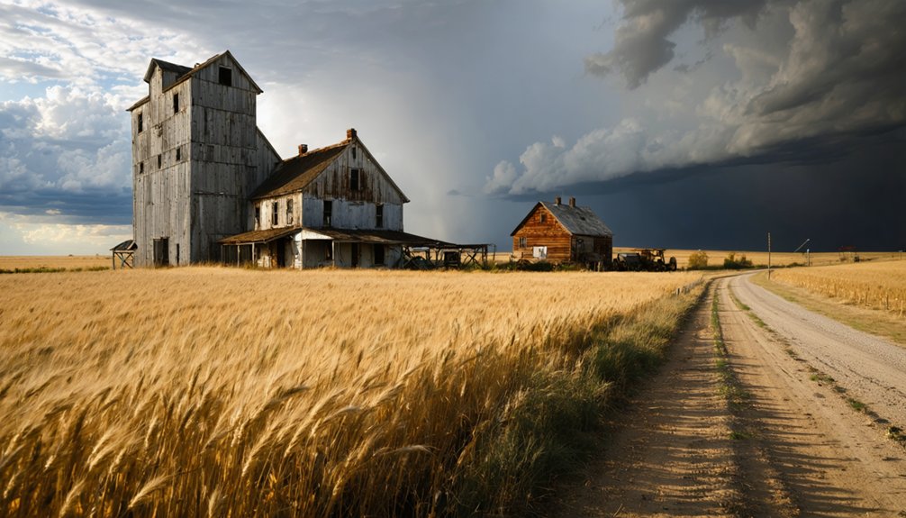
Across Saskatchewan’s windswept plains, the skeletal remains of abandoned grain elevators stand as the most iconic markers of vanished prairie communities.
You’ll find these late 1920s structures in Lepine, Bence, Lake Valley, and Mawer—towering sentinels along defunct rail lines. Built between 1929 and 1931, they once dominated the landscape, spaced strategically for one-day farmer round trips.
Industry consolidation, improved roads, and branch line closures replaced them with modern terminals. Fewer than a few hundred traditional wooden elevators survive today, making elevator preservation increasingly urgent.
Alongside these giants, you’ll discover abandoned churches like Lake Valley United Church (1925-2016), where church restoration efforts struggle against time.
Crumbling main streets reveal scattered remnants: schools, houses, fire trucks—forgotten relics documenting Saskatchewan’s vanished agricultural heritage.
The Ghost Town Trail: A Journey Through 32 Abandoned Communities
Highway 13 carves a 200-kilometer corridor through southern Saskatchewan’s emptiest quarters, threading together 32 abandoned communities that collectively form what locals have christened the Ghost Town Trail.
Between Wauchope and Govenlock, you’ll navigate forgotten stories etched in crumbled homesteads and wind-hollowed structures.
The route demands careful exploration of lost legacies:
- Kayville’s rustic church stands against prairie winds
- Bromhead’s abandoned gas station marks former commerce routes
- Meyronne’s overgrown sidewalks trace vanished neighborhoods
You’ll tread gingerly through tall grass, watching for open wells while photographing decayed buildings.
Paper maps replace GPS here—there’s no café for miles, no amenities softening the stark reality.
In Ferland’s hilltop churches and converted residences, you’ll encounter the physical evidence of communities that once thrived, now surrendered to silence.
Frequently Asked Questions
Are Saskatchewan Ghost Towns Legally Accessible to Visitors and Photographers?
No, you can’t legally access Saskatchewan ghost towns without permission. Legal restrictions require you obtain written consent from property owners before visiting. Visitor guidelines emphasize that abandoned status doesn’t eliminate trespassing laws or ownership rights.
What Happened to Former Residents After Their Towns Were Abandoned?
Former residents relocated to larger Saskatchewan centers or Alberta’s oil fields after their towns collapsed. You’ll find their documented histories preserved through archival photographs and oral testimonies, though individual town memories often remain scattered across descendant families.
Can You Buy Property or Buildings in Saskatchewan Ghost Towns?
You can’t easily buy ghost town property since most exists on privately-owned farmland. Investment potential remains limited—landowners rarely sell parcels, and municipalities demolished unsafe structures, leaving few buildings standing for purchase.
Which Ghost Town Had the Largest Population Before Abandonment?
You’ll find Uranium City held the largest ghost town population before its dramatic decline—achieving near-city status before the Eldorado mine’s closure triggered a complete collapse, leaving behind abandoned infrastructure and scattered residents seeking opportunities elsewhere.
Do Any Ghost Towns Have Restoration or Preservation Projects Underway?
You’ll find restoration efforts underway at Scotsguard, where a couple’s preserved the old church and restored vintage cars. However, most ghost towns face preservation challenges, with structures either repurposed for farming or left deteriorating along the Ghost Town Trail.
References
- https://en.wikipedia.org/wiki/List_of_ghost_towns_in_Saskatchewan
- https://www.sasktoday.ca/north/humboldt-journal/humboldt-author-chronicles-the-ghost-towns-of-saskatchewan-6869776
- https://activehistory.ca/blog/2012/01/19/sad-empty-places-marketing-ghost-towns-in-saskatchewan/
- https://www.youtube.com/watch?v=qG7zMIf6c3s
- https://www.readersdigest.ca/travel/canada/saskatchewan-ghost-towns/
- https://www.youtube.com/watch?v=GDyc46RqKpo
- http://sasktrails.ca/ghost-towns-of-saskatchewan/
- https://moose-jaw-348f.squarespace.com/lifestyles/2023/5/26/vy7lhkgxj1a336w6lmvpbdpoxmno9z
- https://www.youtube.com/watch?v=eRjtKoyqW8w
- https://www.youtube.com/watch?v=VHpJ8KceuB4


