You’ll find South Africa’s ghost towns scattered across landscapes once dominated by gold rushes and military operations. Pilgrim’s Rest produced 6.7 million ounces of gold and now stands as a national monument, while Leydsdorp’s 3,000 fortune seekers abandoned their claims when richer reefs emerged at Witwatersrand. The Mariepskop radar station, operational from 1965 to 2003, remains frozen as an apartheid-era surveillance outpost. These settlements reveal how resource depletion, labor strikes, and political shifts transformed thriving communities into windswept ruins that continue to tell their stories.
Key Takeaways
- Pilgrim’s Rest, South Africa’s only town declared a national monument, preserves authentic mining-era buildings from the historic gold rush.
- Leydsdorp thrived briefly in the 1890s with 3,000 fortune seekers before Witwatersrand’s richer reefs caused abandonment.
- Ghost towns emerged from exhausted mines, labor strikes, environmental encroachment, isolation, and military closures like Mariepskop radar station.
- Explorers need permits, registered guides, respiratory protection, and navigation tools when visiting remote or unstable ghost town sites.
- Photography requires respecting preservation ethics: avoid artifact removal, climbing weak structures, or damaging fragile historical elements.
Pilgrim’s Rest: A Living Monument to Gold Mining Heritage
When “Wheelbarrow” Patterson discovered alluvial gold in Pilgrim’s Creek, he ignited South Africa’s first gold rush and set in motion a transformation that would shape this remote corner of the Transvaal for over a century.
You’ll find that gold mining operations here produced 6.7 million ounces throughout their history, establishing the area’s enduring historical significance.
By 1874, 1500 diggers worked 4000 claims on what became one of the world’s richest goldfields. Though alluvial deposits depleted by 1877, the Transvaal Gold Mining Estates formed in 1895 and continues operating today.
What sets this location apart is its preservation as South Africa’s only town declared a national monument—a living museum where you can explore authentic mining-era buildings and experience the heritage that shaped a nation’s wealth. Visitors can purchase tickets at the Information Centre to access five village museums and guided tours that bring the gold rush era to life. Modern development efforts combine historical infrastructure with contemporary processing technology, positioning the site for continued operations while maintaining its cultural significance.
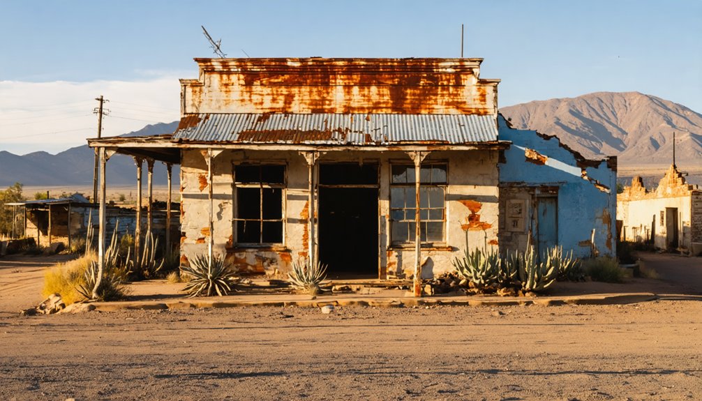
Leydsdorp: Where Prospectors Once Chased Fortune
While Pilgrim’s Rest transformed into a preserved monument of its golden era, Leydsdorp met a starkly different fate in the Murchison Range, 53 kilometres south-east of Tzaneen.
Leydsdorp history began when prospectors struck gold in the late 1880s, swelling the camp to 3,000 fortune-seekers from Alaska to Australia.
Gold mining claims like Blue Jacket and Flying Dutchman dotted the landscape, while eight bars served thirsty miners nicknamed Paraffin Joe and Brandy Smith.
Proclaimed a town in 1890 and named for state secretary Willem Johannes Leyds, it thrived briefly before Witwatersrand’s richer reefs emptied the settlement.
Politics and blackwater fever accelerated the exodus to Johannesburg.
Today, you’ll find only dusty ruins reverting to bushveld—a ghost town where coffins were fashioned from beer crates and fortunes vanished like morning mist.
Eureka City: Diamond Dreams Left Behind
You’ll find forgotten streets revealing lost mining heritage in high terrain, abandoned after early prospecting dreams faded.
While the original Eureka Diamond—cut to 10.73 carats and now displayed at Kimberley Mine Museum—symbolizes diamond heritage that built De Beers’ empire and shaped segregation policies, Eureka City represents overlooked gold pursuits.
This contrast illustrates how mineral wealth created both consolidated power centers and scattered failures across South Africa’s landscape.
The Abandoned Zoo of Cape Town
On the slopes of Table Mountain, Cecil John Rhodes transformed his imperial ambitions into a menagerie in 1896, establishing what would eventually become Cape Town’s forgotten zoo.
Herbert Baker designed the centerpiece Lion Den, drawing inspiration from Italy’s Temple of Poseidon at Paestum. Rhodes envisioned marble colonnades and grand courts, though his 1902 death delayed public opening until 1931.
The 2-hectare property showcased wildebeest, ostriches, and deer across pine-shaded fields. The zoo remained free of charge during its early decades before financial pressures mounted.
The facility stood empty since 1975, marking the end of Rhodes’ vision for showcasing wildlife in architectural splendor.
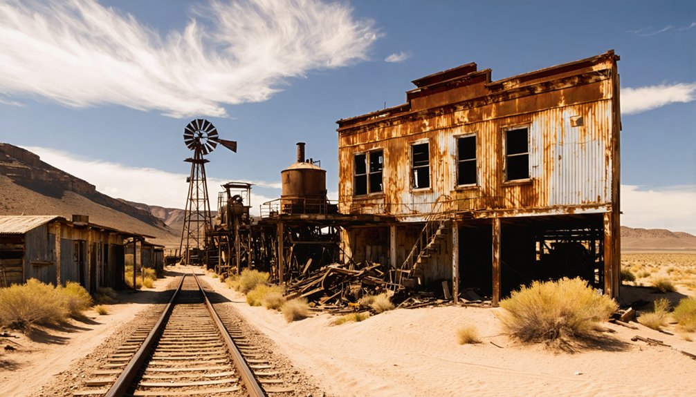
Mariepskop Military Village: Cold War Remnants in the Mountains
Hidden at 24°32′50″S 30°52′24″E atop Mariepskop’s cloud-shrouded summit, you’ll find South Africa’s forgotten radar installation—a ghost town that served as Project NATSEC‘s northernmost early warning post from 1965 until its abandonment in 2003.
The military village housed dozens of families in what became a self-contained community at high elevation, its strategic position near the Mozambique border making it essential for monitoring aircraft movements during the Border Wars. The installation sat upon Proterozoic sedimentary rocks including quartzite, shale, and dolomite formations that provided a stable foundation for the radar equipment and structures.
You can trace the site’s evolution through archival records: from Warrant Officer Rohrbeck’s first summit road in 1957, through Major General Cockbain’s initial surveys hacking through indigenous forest, to the residential complex that once occupied 60% of the installation before operations relocated to Hoedspruit Air Force Base in 1990. At its operational peak, the station supported a population of over 450 personnel including technical specialists, administrative staff, and medical professionals who maintained this isolated mountain outpost.
Abandoned Radar Base History
When Project National Security launched in the 1950s, military planners identified Mariepskop’s 1,944-meter summit as an ideal location for early warning radar against aerial threats from Mozambique, Rhodesia, and Bechuanaland.
Construction accelerated after Warrant Officer W.P.C. Rohrbeck completed the first summit road in February 1957. By 18 November 1965, the radar station became operational, protecting Johannesburg’s gold mines and industrial centers from northern incursions.
The abandoned infrastructure now stands as a monument to apartheid-era military history. Advanced radar systems monitored airspace penetrations throughout the Cold and Border Wars until relocation to Hoedspruit Air Force Base around 1990.
The site’s final abandonment in 2003 left behind a derelict military village where soldiers and families once maintained South Africa’s northern defense perimeter. Today, cloud-shrouded ruins mark this forgotten surveillance outpost.
Exploring the Mountain Ruins
Perched at coordinates 24°32′50″S 30°52′24″E on the escarpment’s edge, Mariepskop’s abandoned military village remains unknown to 90% of Hoedspruit’s residents despite sitting just beyond their northern horizon.
Mountain exploration here reveals a Cold War relic frozen in time—1960s houses and military structures emerging from clouds and indigenous forest undergrowth. The rugged access road, originally completed in February 1957 by Warrant Officer W.P.C. Rohrbeck, winds through dense vegetation to structures abandoned since 2003.
The site’s historical significance extends beyond its radar function; it represents apartheid-era surveillance infrastructure that monitored northern borders against perceived threats.
Today, these derelict buildings stand as evidence of a secretive military past, offering urban explorers tangible connections to South Africa’s classified Cold War operations that once protected the Johannesburg-Pretoria industrial triangle.
Mitchells Plain: A Different Kind of Ghost Town
Unlike traditional ghost towns abandoned to wind and decay, Mitchells Plain represents a different species of emptiness—one born not from economic collapse but from deliberate social engineering.
Established in 1974 under apartheid’s Group Areas Act, this “model suburb” arose at a staggering pace—33 houses daily—to contain Cape Town’s Coloured population 28 kilometres from the city centre.
Thirty-three houses daily—apartheid’s assembly line of displacement, engineering separation at industrial speed.
You’ll find Mitchells Plain history written in forced displacement. Families torn from District Six’s vibrant streets were relocated to this 3,100-hectare settlement, engineered for separation rather than integration.
By 1989, 33,000 dwellings housed nearly 300,000 people in deliberate isolation.
Yet community resilience persists. Where apartheid architects planned containment, residents built neighbourhoods, transforming prescribed emptiness into defiant life.
What Caused These Towns to Be Abandoned?
South Africa’s ghost towns trace their abandonment to a pattern visible across century-old mining records and geological surveys: the exhaustion of underground wealth. When ore deposits dried up, populations fled to richer fields like Witwatersrand, leaving behind abandoned infrastructure that now marks the landscape.
The mining impact extends beyond simple depletion:
- Labor exploitation triggered mass strikes, particularly the 1907 Berlin exodus over wage disputes
- Environmental encroachment buried Spookdorp under sand dunes by 2010
- Geographical isolation doomed settlements like Putsonderwater, accessible only by gravel roads
- Military closures emptied the 1960s Mariepskop radar station
- Railway obsolescence transformed once-vital stops into wilderness
You’ll find these ruins scattered across provinces, monuments to boom-and-bust cycles that defined territorial expansion.
Visiting South Africa’s Ghost Towns Today
When you visit South Africa’s ghost towns today, you’ll find varying levels of accessibility—from Pilgrim’s Rest’s well-preserved walkways to Leydsdorp’s remote dirt roads requiring self-navigation.
These sites demand respect for both safety and preservation, as you’ll encounter unstable mining structures, unmarked graves, and artifacts that have withstood over two centuries of exposure.
Before setting out, research permit requirements for locations like Kolmanskop’s guided tours and understand photography ethics that balance your documentation with protecting these fragile historical records.
Safety Precautions for Explorers
Although South Africa’s ghost towns preserve compelling fragments of mining-era history, their deteriorated state demands rigorous safety measures before exploration.
These abandoned settlements harbor unstable structures, contaminated soil, and unfenced mining shafts that present serious physical hazards. Emergency preparedness proves essential when venturing into these remote locations where cell service fails and urban infrastructure disappears.
Critical safety measures include:
- Respiratory protection: Use N95 or P100 respirators against asbestos, heavy metal dust, and mold in decaying buildings
- Guidance tools: Download offline maps and carry physical compasses to prevent disorientation in sprawling ruins
- Structural awareness: Stay near walls and supports; avoid room centers with compromised floors
- Guided exploration: Hire registered guides who reduce crime risk by 60% while traversing hazardous terrain
- Medical readiness: Secure thorough travel insurance covering evacuation from isolated areas
Accessible Sites and Permits
After understanding these hazards and precautions, you’ll find that South Africa’s ghost towns fall into distinct accessibility categories that determine whether you need permits, guides, or specialized vehicles.
Many accessible ghost towns require no formal permissions. Matjiesfontein, Nieu Bethesda, and Millwood welcome visitors freely, preserving Victorian-era architecture for independent exploration. Copperton, Leydsdorp, and Putsonderwater maintain open access without bureaucratic barriers.
Explorers can also discover abandoned settlements near Acadia National Park, where remnants of history await among the lush landscapes. These forgotten places offer a unique glimpse into the past, inviting adventurers to wander through nature and uncover stories hidden in the overgrowth. Just like the ghost towns, they allow for an immersive experience free from modern distractions.
However, restricted access sites demand preparation. Macassa Beach Pavilion needs 4×4 vehicles and dry conditions, while Mariepskop’s military village hides behind rough mountain roads since 2003.
Sprudorp and Plaatjieskraal operate informally—you’ll visit at your own discretion.
Critical warning: Mitchell’s Plain’s “Ghost Town” remains gang-controlled territory where police won’t enter. Avoid this dangerous zone entirely, regardless of your vehicle or experience level.
Photography and Preservation Ethics
Photographing South Africa’s ghost towns requires balancing artistic documentation with structural preservation, particularly as mining settlements from the 1870s-1950s deteriorate under climatic pressures.
You’ll face photography ethics decisions that directly impact these sites’ survival. Desert-abandoned locations experience accelerated decay through wind erosion and temperature fluctuations, making every footstep consequential.
When documenting these spaces, follow these preservation challenges protocols:
- Don’t remove artifacts, wood fragments, or structural elements as souvenirs
- Avoid climbing weakened staircases, roofs, or support beams
- Stay on established pathways to prevent foundation erosion
- Use natural lighting instead of mounting equipment on fragile walls
- Document graffiti without adding your own marks
Your camera captures history’s final moments. Archival research shows photographer traffic accelerates building collapse rates.
You’re responsible for ensuring future visitors find these settlements intact, not further damaged by documentation pursuits.
Frequently Asked Questions
Are There Guided Tours Available for Ghost Towns in South Africa?
Like compass needles pointing toward forgotten eras, you’ll find guided exploration throughout South Africa’s ghost towns. From Kolmanskop’s sand-swept halls to Kimberley’s mining districts, expert-led tours deliver historical insights into abandoned settlements yearning for rediscovery.
What Safety Precautions Should Visitors Take When Exploring Abandoned Sites?
You’ll need essential safety gear including flashlights, first aid kits, and respirators for mold exposure. Practice wildlife awareness in overgrown areas, travel in groups, stick to daylight hours, and always inform someone of your exploration plans beforehand.
Can You Camp Overnight at Any South African Ghost Town Locations?
You can’t legally camp overnight at South African ghost towns. Camping regulations prohibit unauthorized stays on private or protected land, and these abandoned sites lack ghost town amenities, permits, or safety infrastructure you’d need.
Which Ghost Town Is Closest to Johannesburg for Day Trips?
Witpoortjie Bull Mine in Roodepoort stands closest for your day trip, offering ghost town history from 1960s contamination. You’ll find it between nearby attractions like the local supermarket and Bastion High School within Johannesburg’s limits.
Are Photography Permits Required for Visiting These Historical Sites?
Time-weathered walls stand open to wanderers—South African ghost towns don’t require photography permits. You’re free to capture history without permit fees or photography regulations. Unlike Kolmanskop’s controlled access, these abandoned settlements welcome your lens unrestricted.
References
- https://www.getaway.co.za/?p=15534765
- https://southafrica.net/gl/en/travel/article/historic-leydsdorp-limpopo-s-gold-rush-ghost-town
- https://filmfixers.co.za/2020/05/03/top-10-abandoned-locations/
- https://www.youtube.com/watch?v=SA3ytkfCztM
- https://www.youtube.com/watch?v=nCA4qyZsOSQ
- https://www.atlasobscura.com/things-to-do/south-africa/abandoned
- https://discoveryalert.com.au/historic-mining-revival-south-african-gold-2025/
- https://sagoldpanningassociation.co.za/pilgrims-rest/
- https://www.southafrica.net/gl/en/travel/article/the-royal-hotel-pilgrim-s-rest-the-catholic-church-that-became-a-gold-rush-bar-in-mpumalanga
- https://www.youtube.com/watch?v=I_x8AcxgmTA


