You’ll find Southern Arizona’s ghost towns preserve the region’s mining heritage from the 1880s-1940s, with sites like Pearce (established 1894, population peaked at 1,500), Courtland (2,000 residents by 1909), and Gleeson (600 residents in 1910) offering accessible glimpses into gold, copper, and silver mining communities. Fairbank serves as the region’s best-preserved ghost town with daily access, while Charleston functioned as Tombstone’s milling center before flooding ended operations in 1886. The article below provides detailed directions, historical context, and visiting guidelines for each location.
Key Takeaways
- Pearce features Victorian architecture including a jail and church, with the Commonwealth Mine producing $10.5 million worth of ore from 1895-1942.
- Courtland operates as a private ghost town requiring advance reservations, showcasing foundations, jail walls, and nearly century-old untouched artifacts.
- Gleeson preserves intact structures like a concrete jail and saloon, accessible via well-maintained roads 15-16 miles from Tombstone.
- Charleston served as a milling center for Tombstone’s silver during the 1880s before flooding ended operations in 1886.
- Fairbank is Southern Arizona’s best-preserved ghost town, open daily for exploration with railroad boom history from 1882-1920.
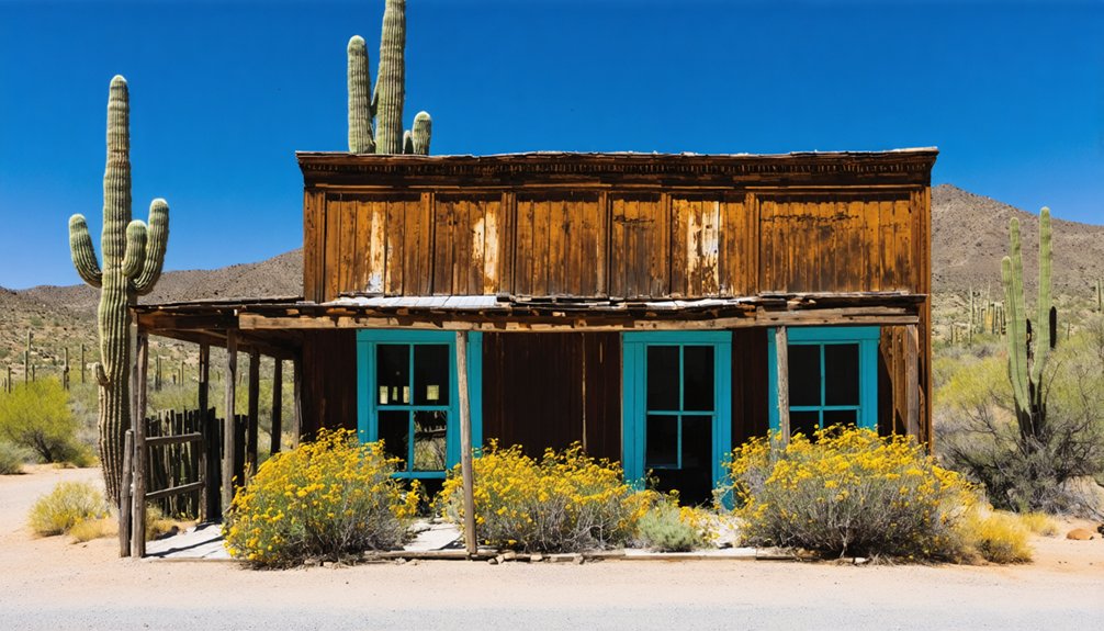
Pearce: a Semi-Abandoned Mining Town With Victorian Charm
In 1894, James Pearce, a Cornish miner and cattleman, discovered gold at what would become the Commonwealth claim on his ranch land in southern Arizona. Following assay confirmation in Tombstone, the Pearce family quickly filed mining claims.
The Commonwealth Mine produced over 1,000,000 tons of ore valued at $10.5 million between 1895 and 1942, making it one of Arizona’s major silver producers. By 1919, the town’s population reached 1,500, supported by a railroad station and 100-stamp mill. The mine featured a 200-stamp mill that processed ore, with gold bars formed heavy enough to prevent theft on horseback.
Pearce history reflects boom-and-bust cycles common to mining communities—prosperity until the 1930s, then decline. The town developed rapidly, with homes moved from Tombstone as residents relocated to the new mining camp.
Today’s semi-abandoned townsite preserves its Victorian architecture, including a two-cell jail (circa 1915) and the restored Our Lady of Victory Catholic Church, maintained by the Old Pearce Preservation Association.
Courtland: Remnants of a Copper Mining Past
Courtland’s copper mining legacy began in 1908 when prospectors discovered a rich vein between Sulphur Springs Valley and the Turquoise mine camp, though claims had been located in the area since the early 1890s.
The Great Western Copper Company, formed in 1900 by the Young brothers from Iowa, named the townsite after Courtland Young in 1909, and by March of that year, the boom town had swelled to 2,000 residents drawn by ore assaying at an exceptional 7.5% copper content. The community quickly developed infrastructure including a weekly newspaper, the Courtland Arizonan, which began publication in February 1909. The camp flourished with rail connections to Cochise and Douglas, ensuring efficient transport of ore and supplies to support the growing mining operations.
Today, you’ll find scattered remnants of this brief but intense mining era, including the stone general store, railroad foundations, and tailings piles that mark where four major companies once extracted approximately 1,750,000 tons of copper ore before operations ceased in the early 1920s.
History of Courtland Mining
Long before prospectors arrived with dreams of copper wealth, Native Americans including the Hohokam worked the Courtland area for turquoise deposits.
By the 1890s, the Tombstone and Bisbee booms drew miners to what became known as Leadville or North Turquoise. Copper mining began in earnest around 1901 on the Humbot claim, yielding $100,000 from oxidized ore.
The 1908 discovery of rich veins assaying at 7.5% copper—far exceeding typical 2-3% grades—transformed the Courtland economy.
Four major companies formed, with the Germania mine reaching peak production of 6,000 tons. Mining techniques involved examining rock and sorting material to ore or waste dumps.
However, shallow ore bodies caused rapid decline by the mid-1910s, ending commercial operations after World War I by 1919. The Great Western Copper Company was formed in 1900 after the Young brothers purchased mining claims in the area.
Visiting Courtland Today
Today, Courtland operates as a private ghost town requiring advance reservations for all visits.
You’ll need to call 520-585-6555 or email courtlandghosttown@gmail.com before arriving at 11724 N. Ghost Town Trail in Elfrida. The site remains closed to casual visitors due to ongoing prospecting and mining activities monitored by 24/7 security cameras.
Courtland tours reveal scattered foundations, crumbling hotel remnants, weathered jail walls, and original sidewalks from the town’s copper boom era.
You’ll find artifacts untouched for nearly a century—nothing’s staged here. The resident guide offers access to a nearby turquoise mine operating since the 1970s, where you can collect stones for personal jewelry. This new resident offering guided tours has transformed the mostly ruined town into an accessible historical destination.
Self-guided mineral collecting isn’t permitted.
These ghost town memories face development threats, making preservation efforts by the Arizona Land Project increasingly critical for National Historic Designation. The town is located approximately 20 miles from Tombstone along the historic Ghost Town Trail connecting Pierce and Gleason.
As visitors seek to explore ghost towns in Arizona, they not only uncover the rich history of the American Southwest but also appreciate the unique stories behind each deserted building and ghostly street. These sites offer a nostalgic glimpse into a bygone era, making them popular destinations for history enthusiasts and adventure seekers alike. By supporting local preservation initiatives, tourists can help ensure these fascinating remnants of the past endure for future generations to experience.
Gleeson: Preserved Structures Along the Ghost Town Trail
You’ll find Gleeson approximately 15-16 miles from Tombstone along the Ghost Town Trail, where ruins of a copper mining community that peaked at 600 residents in 1910 remain accessible for exploration.
The town’s preserved structures include a restored concrete jail built in 1910 (now operating as a museum), the remains of Joe Bono’s saloon and the old post office, plus foundations of the hospital, school, and several adobe buildings constructed after a devastating 1912 fire destroyed 28 original structures.
Mining operations at sites like the Copper Belle Mine sustained this community from John Gleeson’s 1900 claim filing until the post office’s closure on March 31, 1939, with visible remnants including mine tailings, the Copper Belle headframe, and a cemetery located west of town on the road to Tombstone. Before the concrete jail was constructed, prisoners were chained to the Jail Tree, a practice that continued until a wooden jail was built but proved short-lived due to escape attempts. The town was originally named Turquoise in 1890 but lasted only four years before being renamed after John Gleeson registered his claim.
Historic Buildings Still Standing
While many Arizona ghost towns have deteriorated into mere foundations and rubble, Gleeson preserves a remarkable collection of intact historic structures along its Ghost Town Trail.
You’ll find Joe Bono’s Saloon standing with walls intact, featuring a 1982 mural depicting townsfolk from its combination saloon-general store days.
The concrete jail, built in 1910 to replace both a wooden predecessor and an oak tree used for prisoners, now serves as a local museum open first and fourth Saturdays monthly.
The old post office, which closed March 31, 1939, remains viewable from the road near town center.
North of main street, hospital ruins mark where medical services operated during Gleeson’s peak population.
Two prominent columns stand as landmarks visible from the road, marking remnants of past structures along the approximately one-mile town length.
These preservation efforts showcase authentic Gleeson history through tangible structures rather than archaeological remnants.
Accessing the Remote Site
Reaching Gleeson requires traversing approximately 16 miles of unpaved roads from Tombstone, though the journey proves manageable for standard passenger vehicles.
You’ll head east on State Route 80 to Camino San Rafael, turn left for one mile, then right onto Gleeson Road for the remaining 14-15 miles.
This dusty but well-maintained route offers remote accessibility through desert scrub beneath the Dragoon Mountains’ shadow, following a historic military path soldiers used between Fort Bowie and Fort Huachuca during the 1870s-1880s.
The scenic routes wind through rolling hills, requiring less than 30 minutes of driving time.
You’ll find well-marked turnoffs, though you should bring water and supplies since no facilities exist along this off-beaten-path corridor through Southern Arizona’s mining heritage.
Mining Heritage and Cemetery
Long before white prospectors arrived, Native Americans extracted turquoise from Gleeson’s mineral-rich terrain for decorative purposes.
White settlers discovered copper, lead, and silver deposits in the late 1800s, establishing the Turquoise camp with a post office in 1890.
John Gleeson’s 1896 purchase of the Leonard claims created the Copper Belle mine, which became the district’s primary copper producer.
The mining culture that developed here left tangible markers of frontier life:
- The preserved jail stands as evidence to lawless boom-town days
- Cemetery preservation efforts protect miners’ final resting places
- Ghost Town Trail structures reveal daily operations and living conditions
Production peaked during World War I before mines ceased operations in the 1930s-1940s.
The post office closed March 31, 1939, cementing Gleeson’s transformation into Arizona’s accessible mining heritage site.
Charleston: The Mill Town on the San Pedro River
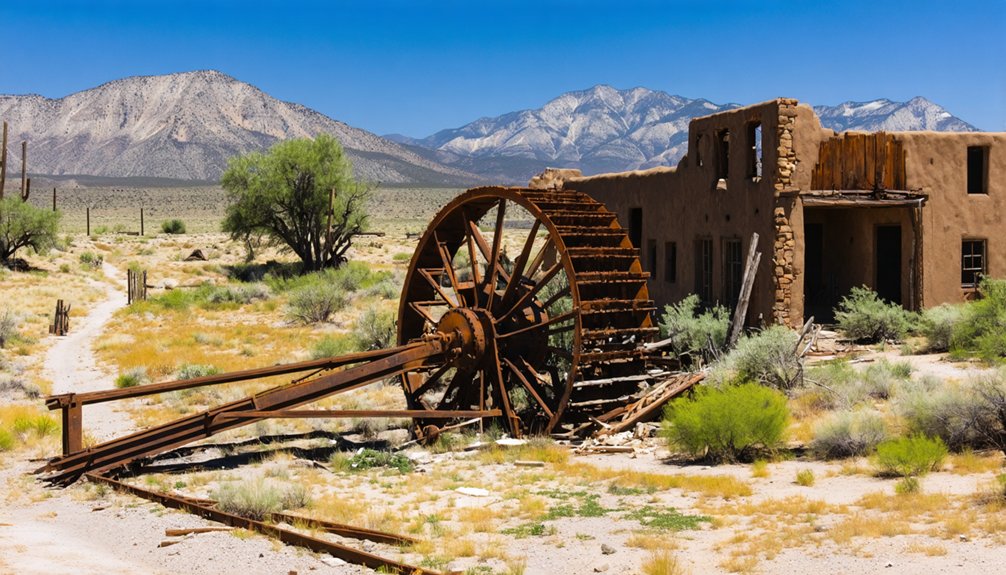
Nine miles downstream from Tombstone along the San Pedro River, Charleston emerged in the late 1870s as a critical milling center for processing the silver boom ore extracted from Tombstone’s increasingly productive mines.
You’ll find Millville history intertwined with Charleston’s founding—Millville appeared first when Richard Gird established the Tombstone Mill and Mining Company in 1879.
Across the river, William Stowe claimed 160 acres under the Homestead Act in 1878, plotting a 24-block townsite. By 1880, the Gird and Corbin Mills operated alongside a 200-foot dam built a mile upstream.
The population swelled past 400 residents during the early 1880s, supporting over 3,000 mining claims. However, when Tombstone’s mines flooded at 520-foot depth in 1886, Charleston’s purpose vanished, becoming a ghost town by 1889.
Fairbank: a Well-Maintained Historic Site With Guided Access
Where the San Pedro and Babocomari Rivers converge, Fairbank stands as Southern Arizona’s best-preserved ghost town, its origins tracing back to an 18th-century Native American village called Santa Cruz.
Settled in the late 1870s as Junction City, this strategic stagecoach stop became Fairbank in 1883, named for Chicago investor Nathaniel Fairbank.
From dusty stagecoach crossroads to railroad hub, Junction City transformed into Fairbank through one investor’s vision and frontier ambition.
Fairbank history unfolded through three critical phases:
- Railroad boom (1882-1920): Three rail lines transported Tombstone’s silver ore, supporting 269 residents by 1920.
- Catastrophic decline (1886-1973): Mine flooding, earthquakes, floods, and automotive competition emptied the town.
- Modern preservation efforts (1986-present): Bureau of Land Management protection enables you to explore standing structures, interpretive plaques, and the adjacent pioneer cemetery daily from 9:30-4:30.
Duquesne: Remote Mining Camp in Coronado National Forest
Deep within the rugged hills of Coronado National Forest, the ghost town of Duquesne (pronounced “doo-kane”) emerged in the late 1880s when the Duquesne Mining and Reduction Company transformed this remote hillside into a planned mining community.
Located half a mile south of Washington Camp along FR 61, this carefully organized settlement featured designated residential and administrative zones housing approximately 1,000 residents at its peak.
Duquesne history reveals impressive production, with mines allegedly generating over $4,000 weekly during boom periods.
However, after changing ownership multiple times, operations never regained profitability. The mining techniques employed left lasting evidence—visible shafts, tailings, and deteriorating buildings scattered across the landscape.
You’ll reach this isolated ghost town via FR 128, a challenging forest road that tests your vehicle’s capabilities while offering glimpses into Southern Arizona’s mining heritage.
Planning Your Ghost Town Trail Adventure
While Duquesne offers a glimpse into one isolated mining operation, you’ll discover a more extensive mining heritage experience by exploring the Ghost Town Trail, which connects three historically significant settlements—Pearce, Courtland, and Gleeson—near Sunsites east of Tombstone.
From Tombstone, head southeast on State Route 80 for 0.7 miles to Camino San Rafael, then north 1.1 miles to Gleeson Road. Turn right for 15.5 miles to Ghost Town Trail.
Navigate southeast from Tombstone on Highway 80, then wind north through desert roads to reach the historic Ghost Town Trail.
Essential Safety Precautions:
- Travel unpaved sections only in good weather
- Bring water and emergency supplies for remote areas
- Avoid entering unstable structures during ghost town photography
Gleeson’s 1910 jail and abandoned hospital provide authentic settings, while Pearce’s semi-abandoned streets feature mine workings and Our Lady of Victory Catholic Church.
Best Practices for Exploring Abandoned Mining Sites
Although Southern Arizona’s abandoned mining sites offer compelling historical insights, exploring these locations requires strict adherence to safety protocols that have evolved from decades of preventable accidents.
You’ll need thorough risk awareness before approaching vertical shafts that plunge hundreds of feet, water-filled pits concealing electrical hazards, and collapse zones with unstable highwalls.
Implement essential safety precautions: conduct hazard assessments, assemble protective equipment including helmets and sturdy boots, and prepare emergency response plans.
Never enter standing water without probing for drop-offs, maintain distance from deteriorating structures with weakened support timbers, and avoid unventilated areas harboring toxic air.
With approximately 500,000 abandoned mines nationwide and drowning ranking as the leading cause of death at these sites, you’re responsible for understanding that dozens suffer injuries or fatalities yearly from preventable exploration incidents.
Frequently Asked Questions
Are Ghost Towns in Southern Arizona Safe to Visit With Children?
Ghost towns aren’t inherently child-safe due to structural collapse risks and wildlife hazards. You’ll need strict safety tips—avoid entering buildings, carry water, and choose family friendly activities at managed sites like Vulture City over remote, abandoned locations.
What Is the Best Time of Year to Explore Arizona Ghost Towns?
Winter offers ideal conditions for fall exploration through mid-March, when cooler temperatures enable comfortable hiking and superior photography. Avoid summer adventures entirely—intense heat creates dangerous conditions and obscures architectural details you’ll want to document thoroughly.
Do I Need Permits to Visit Ghost Towns on Public Land?
You don’t need permits for most public land ghost towns like Fairbank and Swansea, managed by BLM. Day use is free, though camping requires specific permits under federal permit regulations governing designated areas.
Can I Use Metal Detectors at Arizona Ghost Town Sites?
Don’t let your treasure-hunting dreams crash—you can’t use metal detectors at Arizona ghost town sites. Metal detecting regulations and historical preservation laws strictly prohibit disturbing archaeological resources, protecting our shared heritage from irreversible loss.
Are There Camping Facilities Near the Ghost Town Trail?
Kentucky Camp offers primitive campsites and rentable cabins with camping amenities along Arizona’s ghost town trails, while other historic mining sites like Swansea, Harshaw, and Goldfield lack designated facilities. You’ll need Forest Service reservations for Kentucky Camp’s accommodations.
References
- https://www.arizonahighways.com/article/arizona-ghost-towns
- https://en.wikipedia.org/wiki/List_of_ghost_towns_in_Arizona
- https://www.desertusa.com/desert-arizona/ghost-town-arizona.html
- https://southernarizonaguide.com/ghost-towns-southern-arizona/
- https://www.visitarizona.com/like-a-local/4-arizona-ghost-towns-you-may-have-never-heard-of
- https://www.youtube.com/watch?v=JaM1YRjN4Jc
- https://pinintheatlas.com/travel-blogs/ghost-towns/
- https://www.tripadvisor.com/Attractions-g28924-Activities-c47-t14-Arizona.html
- https://www.legendsofamerica.com/az-ghosttowntrail/
- https://westernmininghistory.com/towns/arizona/pearce/


