You’ll find Southern Oregon’s ghost towns scattered across the Siskiyou Mountains, remnants of the 1851 gold rush that transformed the region. Boomtowns like Sterlingville grew to 1,200 residents by 1855 before being abandoned when mines played out. Buncom, Golden, and camps along the Illinois River Valley tell similar stories of rapid prosperity followed by decline. These settlements vanished due to exhausted ore deposits, catastrophic fires, floods, and geographic isolation that left them economically vulnerable. The landscape still reveals traces of this boom-and-bust cycle that shaped the area’s history.
Key Takeaways
- Gold discovered in 1851 prompted mining camps across Rogue, Illinois, and Applegate Valleys in Southern Oregon.
- Notable ghost towns include Waldo, Sailors Diggings, Browntown, Buncom, Sterlingville, and Golden’s Temperance Town along Coyote Creek.
- Sterlingville boomed to 1,200 residents by 1855 but was abandoned by 1957 after mining shafts undermined buildings.
- Mining exhaustion, catastrophic fires, floods, and geographic isolation transformed boomtowns into abandoned settlements throughout the region.
- Buncom evolved from Chinese
The Gold Rush Era That Shaped Southern Oregon
The discovery of gold in Southern Oregon began in May 1851 when prospectors found deposits along Josephine Creek. This gold discovery triggered immediate exploration throughout the region. Within weeks, miners struck gold on Canyon Creek, Scott’s and Allen gulches at Waldo, and near present-day Jacksonville by December 1851.
The prospectors influx transformed the landscape rapidly. Thousands abandoned California’s crowded goldfields and Willamette Valley farms to seek fortune in the Rogue, Illinois, and Applegate Valleys.
Between 1851-1855, miners crossed the Siskiyou Mountains near Ashland, scattering across Southern Oregon’s river valleys. They brought shopkeepers, farmers, and teamsters who’d supply the mining operations. Agricultural products from Oregon met the surging demand from mining communities, further integrating regional economies.
What started as isolated creek panning evolved into a full-scale rush that’d reshape the territory forever. The gold rush attracted many Chinese miners to the region, with some communities like Buncom being founded by Chinese miners as early as 1851 and later seeing an influx of over 500 Chinese workers in other areas.
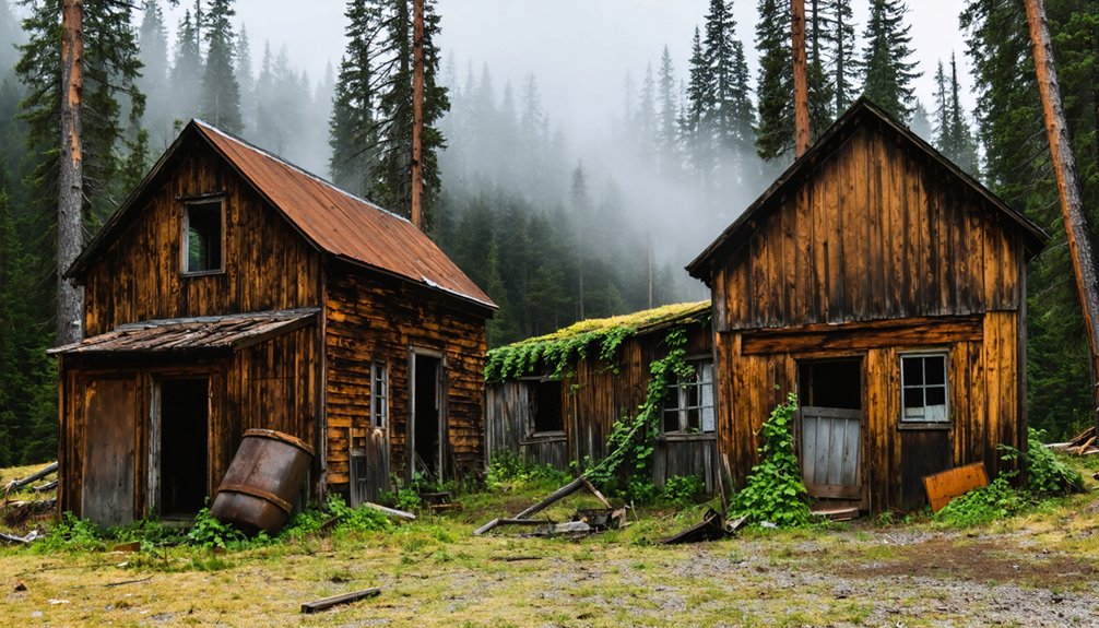
Buncom: A Preserved Glimpse Into Mining History
Among the countless camps that sprouted across Southern Oregon during the 1851 gold rush, Buncom stands today as one of the region’s most intact mining settlements.
Chinese miners first established the camp following gold discoveries at Jacksonville and Sterling Creek, building on Dakubetede homelands. The Phillips brothers arrived as permanent settlers in the 1850s, filing homestead claims by the 1860s.
Buncom history transformed from mining camp to trade hub when the post office opened in 1896, serving the Little Applegate Valley’s farmers and ranchers.
The community’s mining heritage extended beyond gold to include silver, cinnabar, and chromium extraction. By 1918, depleted reserves forced the post office’s closure.
Today, three early 1900s buildings remain—the post office, cookhouse, and bunkhouse—preserved by the Buncom Historical Society since 1991. Visitors can reach the site via Griffin Creek Lane, though the route includes five miles of unpaved road with narrow, winding conditions through dense madrone forests. The name Buncom appears on disambiguation pages due to its association with multiple related topics and locations.
Golden: The Temperance Town on Coyote Creek
You’ll find Golden’s mining camp origins along Coyote Creek’s south side, where prospectors discovered deep, rich diggings in 1852.
The Texas Company established the area’s first major operation with a 114-foot shaft equipped with a steam engine, while Towle, Gillett & Co., Harper Claim, and Lone Star Claim on the west side yielded over $130,000 in combined production.
Water seepage posed significant challenges for mining operations, requiring extensive drainage tunnels to manage water flowing through the main lead.
Coyote Creek historically supported steelhead trout and chinook salmon that migrated upstream to spawn through this region.
Today, waste rock piles, gravel deposits, stone foundations, and fencing mark the former claim sites between Ansil Davis Road and Monge Ranch Road, though vegetation has largely reclaimed the landscape.
Mining Camp Origins
When gold fever swept across the American West during the early 1850s, placer miners descended on Coyote Creek in southwestern Oregon Territory, establishing rough camps that would eventually become known as Goldsville.
You’ll find these goldfields were actively worked throughout the decade, though neighboring Idaho strikes temporarily drew miners away during the 1860s. Chinese miners arrived following the Salmon River strike but faced displacement by white prospectors.
Mining techniques evolved considerably during the 1870s when hydraulic giants were introduced, washing down entire hillsides for gold extraction—damage you can still observe today.
This resurgence in Coyote Creek’s diggings proved substantial enough that the Oregon-California Stage Company rerouted passengers, mail, and goods through the area. Rev. William Ruble and his family established their settlement during this period in the late 1870s, purchasing most of the mines and claims in the region.
By the mid-1880s, Ruble owned all claims in the area and leased them to other miners. Placer mining activity peaked, transforming these rough camps into permanent settlements.
Remaining Historic Structures
Unlike the boisterous mining camps that dotted Coyote Creek during the gold rush decades, Golden emerged in 1890 as a deliberate experiment in moral reform when Rev. Ruble and his sons established a temperance settlement.
You’ll find the 1892 Campbellite church standing as the primary religious structure, reflecting the founders’ spiritual priorities.
The Rubles’ 1892 residence and the 1904 general store—which housed the post office established in 1896—demonstrate the town’s commercial development.
A school building served 36 students by 1906, positioned near the mercantile center.
Property deed restrictions prohibited the sale or manufacture of alcohol throughout the settlement, following a model used by other temperance communities of the era.
The population peaked at 150 residents despite the absence of saloons that characterized most mining communities.
Today, these structures hold architectural significance under Oregon Parks and Recreation Department stewardship.
The National Register of Historic Places listing and state heritage designation guarantee historic preservation for this unique temperance settlement.
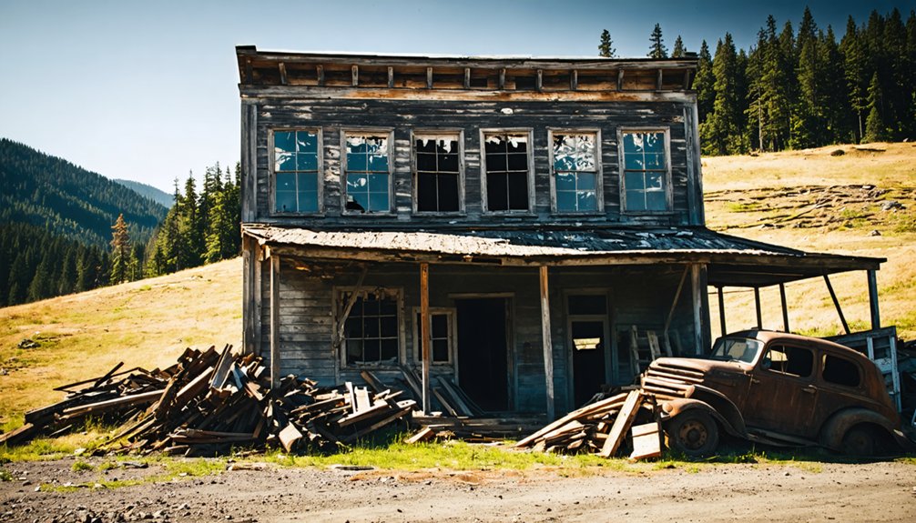
Sterlingville: From Boomtown to Buried Past
In June 1854, James Sterling and Aaron Davis struck gold at the headwaters of Sterling Creek, transforming their Donation Land Claim in Eden Precinct from farmland into one of Oregon’s most promising mining sites.
Their initial exploration with three companions revealed extensive deposits, though secrecy proved impossible—miners flooded the area upon their return. Jackson County Court established Sterling election precinct by July 10, 1854.
Sterlingville history shows rapid growth to 1,200 residents, supporting saloons, boarding houses, and gambling halls by 1855.
Within a single year of the gold strike, Sterlingville exploded into a frontier boomtown of over a thousand fortune-seekers.
Gold mining techniques included Oregon’s largest hydraulic operations, with 500 miners working claims through 1885. The Great Depression sparked revival, employing 100 properties by 1933.
Mining shafts gradually undermined buildings, leaving the town abandoned by 1957. Today, only Sterlingville Cemetery remains, accessible via Sterling Creek Road.
Illinois River Valley’s Forgotten Mining Camps
Gold fever reached the Illinois River Valley in 1851 when prospectors discovered rich deposits on Josephine Creek, a tributary that would give its name to the entire county.
You’ll find remnants of forgotten camps like Waldo, Sailors Diggings, and Browntown scattered throughout this rugged terrain.
These settlements sprang up rapidly around productive sites like Independence Placer and Gold Blanket, where miners extracted fortunes from the earth.
Why These Towns Vanished: Forces of Decline
Southern Oregon’s ghost towns fell victim to two primary forces: the inherent volatility of resource extraction economies and the region’s vulnerability to natural disasters.
These factors contributed to the rise of abandoned settlements on the Oregon coast, where once-thriving communities now lay in ruins. The remnants of these towns serve as a haunting reminder of the dreams that were lost, overtaken by the forces of nature and economic uncertainty. As the tide rolls in, the old structures can be seen jutting out of the sand, echoing the stories of those who once called these places home.
You’ll find that mining exhaustion eliminated the economic foundation of gold and silver boomtowns once ore deposits were depleted or became financially unfeasible to extract.
Catastrophic fires, severe winter storms, and the region’s isolation compounded these economic collapses, transforming once-thriving communities into abandoned settlements.
Economic Boom and Bust
When precious metal deposits first drew prospectors to southern Oregon in the mid-nineteenth century, entire communities sprang up around mining claims with extraordinary speed.
You’ll find this boom-and-bust pattern repeated across resource-dependent settlements. Towns lacking economic resilience faced inevitable decline once veins played out.
The cycle devastated communities through:
- Initial population surges followed by long-term negative effects after the first decade of mining activity
- Drastically reduced entrepreneurship and employment growth at exhausted sites
- Greatest vulnerability among smaller, isolated towns without diversification potential
Oregon’s timber industry repeated this pattern. The 1980s recession eliminated manufacturing jobs despite restored output through automation.
Mills retooled with fewer workers. When Josephine County’s final sawmill closed in 2013, it marked decades of irreversible decline across rural industrial clusters.
Natural Disasters and Isolation
While economic forces gradually eroded mining communities over decades, natural disasters eliminated some Oregon settlements in mere hours.
Flood impacts devastated multiple communities: the 1948 Columbia River flood destroyed Vanport in one day, displacing 18,500 residents from Oregon’s second-largest city. The Great Flood of 1862 erased Linn City and Orleans entirely.
Erosion effects proved equally destructive at Bayocean, where coastal processes consumed the “town that fell into the sea” between the 1920s and 1950s.
Geographic isolation doomed others without catastrophic events. Greenhorn’s 6,000-foot elevation left it snow-buried winters, losing two-thirds of its population by 1910.
Sterlingville vanished into overgrowth. Golden and Weatherby faded in Baker County’s remote reaches, inaccessible and forgotten.
Frequently Asked Questions
Can Visitors Legally Explore Ghost Town Sites on Private Property?
No, you can’t legally explore ghost towns on private property without permission. Oregon’s property rights laws protect owners through ORS 164.245, requiring posted notices for legal access. Trespassing risks criminal charges regardless of historical significance.
However, if you venture into the ghost towns of eastern Oregon, you will discover fascinating remnants of the past. These locations often tell stories of the gold rush, mining booms, and the people who once inhabited them. Each site offers a unique glimpse into Oregon’s history, attracting adventurers and history enthusiasts alike.
What Artifacts Are Commonly Found at Southern Oregon Ghost Town Sites?
You’ll find gold nuggets, Levi Strauss rivets, glass beads, and mining equipment from dredging operations. Historical documents include preserved postmarks, while church buildings, schoolhouses, and cemetery markers remain as structural artifacts documenting settlement periods.
Are Guided Tours Available for Any Southern Oregon Ghost Towns?
Like prospectors charting their own claims, you’ll navigate Southern Oregon’s ghost towns independently—no formal guided experiences exist for Golden or Buncom. Self-directed exploration lets you discover their historical significance freely through atmospheric wandering and personal discovery.
How Do I Find Exact Locations of Lesser-Known Ghost Towns?
You’ll find lesser-known ghost towns through historical research at county archives and libraries, consulting USGS topographic maps, and using online maps like Wikipedia’s Oregon ghost town listings that document over 200 sites statewide.
Exploring abandoned towns in Oregon offers a unique glimpse into the state’s history and the lives of those who once inhabited them. Each deserted street and crumbling building tells a story of prosperity and decline, often linked to the mining booms or logging industry that once thrived in the region. As you uncover these forgotten places, you’ll encounter both natural beauty and the echoes of the past that make Oregon’s landscape truly compelling.
The tales of abandoned towns in Oregon reveal a rich tapestry of human experience, often marked by hardship and resilience. Visitors may find remnants of old railroads and derelict homes, each site evoking a sense of nostalgia and curiosity about the past. As you walk through these forgotten streets, you’ll feel a connection to the lives that once thrived in these now-silent communities.
What Safety Precautions Should Visitors Take When Exploring Ghost Towns?
Before you livestream your adventure, you’ll need wildlife encounter awareness, weather preparedness gear, first-aid supplies, sturdy footwear, flashlights, maps, and research. Check road conditions, respect closed areas, and never disturb historical structures or natural features.
References
- https://en.wikipedia.org/wiki/List_of_ghost_towns_in_Oregon
- https://www.travelmedford.org/southern-oregon-ghost-towns-
- https://indigocreekoutfitters.com/news/2022/05/05/exploring-southern-oregons-ghost-towns/
- https://www.visitoregon.com/oregon-ghost-towns/
- http://www.photographoregon.com/ghost-towns.html
- https://www.nationaldaycalendar.com/lists/12-oregon-ghost-towns
- https://eaglepointgolf.com/southern-oregons-ghost-towns-provide-a-haunting-adventure/
- https://www.oregonencyclopedia.org/articles/ghost_towns_illinois_river_valley/
- https://traveloregon.com/things-to-do/culture-history/ghost-towns/
- https://freepages.rootsweb.com/~gtusa/history/usa/or.htm


