You’ll find Southern Utah’s most fascinating ghost towns scattered between Zion and Bryce Canyon, where floods, mining booms, and economic collapse left behind preserved remnants of 1850s-1900s settlement life. Grafton’s adobe buildings appeared in “Butch Cassidy and the Sundance Kid,” while Silver Reef’s sandstone-hosted silver deposits defied geological expectations. Old Irontown preserves its blast furnace from Brigham Young’s 1868 Iron Mission, and remote sites like Sego Canyon blend ancient petroglyphs with coal mining history. Each location offers unique architectural features and stories that reveal the challenges pioneers faced in Utah’s unforgiving desert landscape.
Key Takeaways
- Grafton, established in 1859, features an 1886 adobe schoolhouse and appeared in “Butch Cassidy and the Sundance Kid.”
- Silver Reef’s unique sandstone silver deposits attracted over 1,000 prospectors by 1877, peaking at 1,046 residents in 1880.
- Old Irontown preserves a blast furnace chimney and charcoal kilns from the 1868 Iron Mission, producing 5-7 tons daily.
- Sego Canyon combines ancient rock art from 7000 B.C. with coal mining history beginning in 1908.
- Visitors should bring reliable maps, respect preservation guidelines, and verify property boundaries before exploring ghost towns.
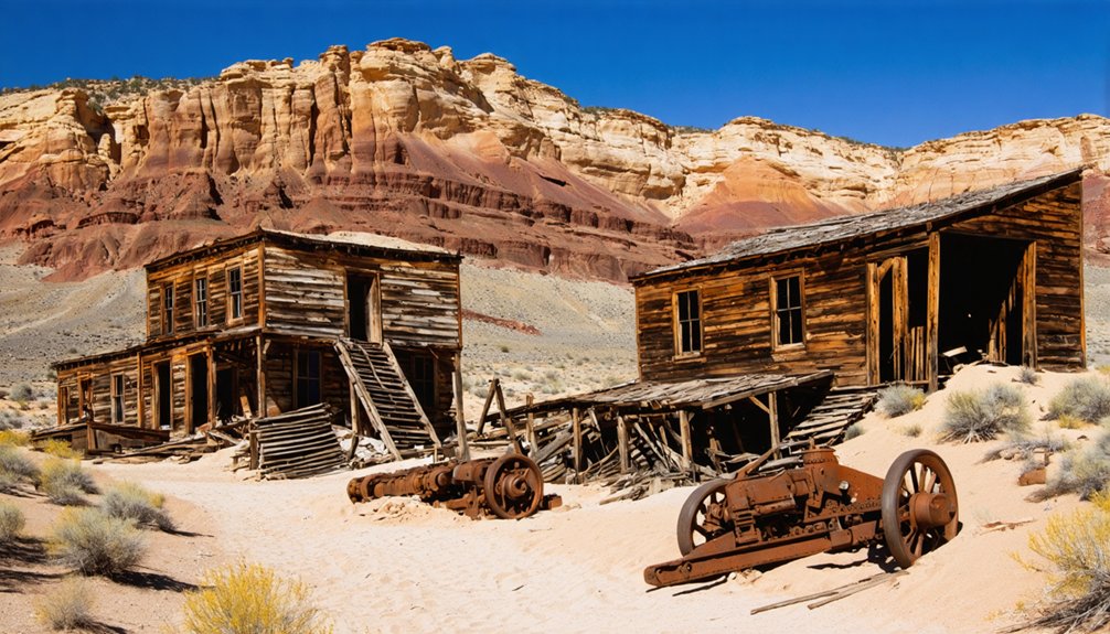
Grafton: A Cinematic Desert Settlement Near Zion
In 1859, five families left Virgin to establish Wheeler seven miles west along the Virgin River’s fertile floodplain, drawn by the promise of cotton cultivation and agricultural opportunity in Utah’s territorial expanse.
After catastrophic flooding destroyed Wheeler in 1862, survivors relocated upstream and renamed their settlement Grafton. The Grafton history reveals persistent struggle—devastating floods in 1862 and 1868, conflicts during the Black Hawk War that killed three Berry brothers in 1866, and relentless silt choking irrigation channels.
Grafton’s settlers endured catastrophic floods, deadly warfare, and failing irrigation in their desperate struggle to sustain community life.
By 1866, Grafton’s 168 residents made it Virgin Valley’s second-largest community. The Grafton architecture you’ll encounter today includes the iconic 1886 adobe schoolhouse, John Wood’s 1877 homestead beneath ancient cottonwoods, and Alonzo Russell’s elegant two-story residence. The Grafton Cemetery, established in 1862, served the community’s residents until 1924.
When Hurricane Canal diverted water downstream in 1906, families abandoned subsistence farming, with the last resident departing in 1944. Despite its decline, Grafton achieved cinematic immortality when Paul Newman performed bicycle stunts there during filming of the four-time Academy Award-winning “Butch Cassidy and the Sundance Kid” in 1969.
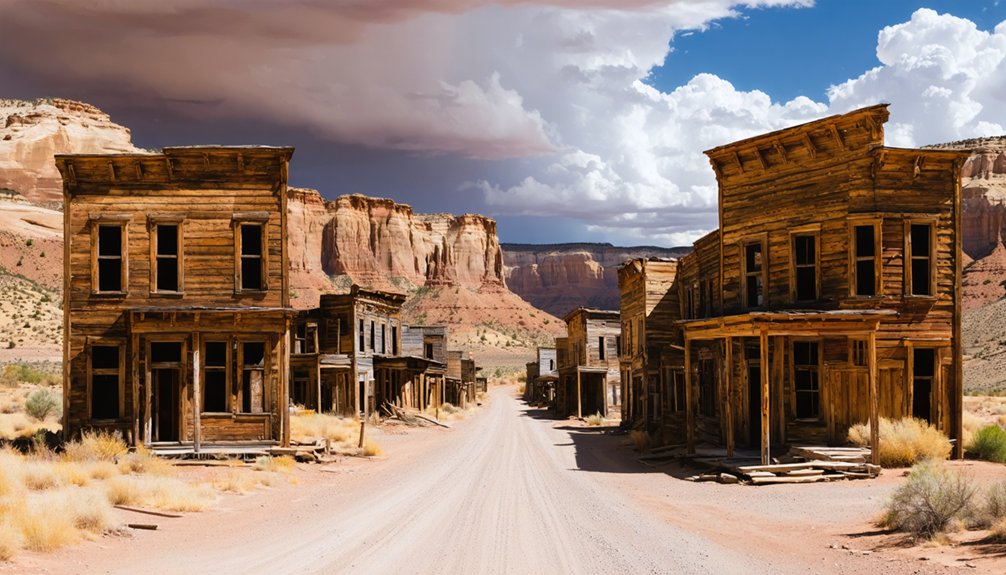
Silver Reef: Where Silver Defied Geological Odds
When John Kemple sheltered in Leeds during 1866, he spotted silver gleaming in overheated sandstone—a discovery that confounded mining experts who insisted such deposits couldn’t exist in soft rock.
You’ll find that skepticism nearly killed the camp before it started, as the Walker Brothers withdrew their backing after geologists dismissed the find as impossible.
Yet fortune seekers and scientists alike flocked to the site, drawn by the geological anomaly that would transform barren cliffs into a thriving boomtown.
By early 1877, the camp attracted over 1,000 prospectors eager to stake their claims in the limestone cliffs of the Pine Valley Mountains.
Discovery in Sandstone Formation
The silver discovery at Silver Reef shattered every geological principle miners and scientists held sacred. When John Kemple reported silver mineralization in sandstone during the late 1860s, geologists dismissed him with derision. The Smithsonian even labeled his sample an “interesting fake”—precious metals simply didn’t occur in sandstone formations.
Yet the geological significance proved undeniable. You’re looking at the world’s only known silver deposits hosted in sandstone, specifically the Springdale Sandstone Member of the Moenave Formation. The light-colored, cross-stratified rock defied conventional wisdom by containing bonanza-grade silver chloride ores. Folding in sandstone created the structural traps that localized these extraordinary metal values, though the ultimate origins of the deposits continue to spark debate among geologists.
The mining rush finally erupted in the mid-1870s after prospectors verified Kemple’s claims firsthand, transforming scientific skepticism into economic reality and establishing Silver Reef’s place in mining history. Later investigations would reveal uranium-vanadium mineralization in the same Chinle formation sandstones that defied geological expectations, adding another layer to the district’s remarkable story.
Bonanza City to Silver Reef
After John Kemple’s 1866 discovery languished in obscurity for nearly a decade, William Tecumseh Barbee arrived in late 1875 with backing from Utah’s powerful Walker brothers to investigate the sandstone silver reports. He staked 22 claims and established Bonanza City, but his inflated lot prices quickly priced out ordinary prospectors.
When the Pioche, Nevada mines shuttered in November 1875, displaced miners flooded the area and erected “Rockpile,” a sprawling tent city where free enterprise thrived without land speculators controlling access. By April 1876, Silver Reef City emerged and absorbed Bonanza City, transforming into a bustling town that would soon support nearly 2,000 residents.
The 1880 Census recorded a population of 1,046, marking the height of Silver Reef’s prosperity before the inevitable decline that followed falling silver prices and mine closures.
Old Irontown: The Best Preserved Iron Mining Site
Twenty-four miles west of Cedar City, Old Irontown stands as Utah’s most intact 19th-century iron mining site and the final chapter of Brigham Young’s ambitious Iron Mission. Founded in 1868 after Cedar City’s ironworks failed, this remote settlement peaked at 97 residents in 1870, producing 5-7 tons of pig iron daily for the Utah Western Railroad and Pioche mines.
You’ll find remarkable Iron Heritage at this state park:
- Blast furnace chimney and foundry walls documenting industrial archaeology
- Beehive-shaped charcoal kilns where juniper and pinyon pine fueled production
- Worker cabins and arastra grinding device along interpretive trails
- National Register listing recognizing its Historical Significance since 1971
The Panic of 1873 and cheaper eastern iron killed operations by 1876, creating Utah’s first ghost town. Despite the abandonment, Iron Mountain remains one of the richest iron deposits in the United States, with ore mining continuing for decades after Old Irontown closed. The site offers free admission for visitors exploring its quiet paths and historical placards.
Access via Old Irontown Road off State Route 56.
Osiris: A Mill Town Gateway to Bryce Canyon
You’ll find Osiris’s grain mill rising above Highway 22 in Black Canyon, about 10 miles south of Antimony—a stark sentinel from the settlement’s brief agricultural experiment between 1910 and the 1920s.
The Holt family’s creamery required workers to remove entire roof sections during equipment installation, demonstrating the ambitious scale of operations that water scarcity would ultimately doom.
Today, three buildings survive along this scenic corridor to Bryce Canyon National Park, with the fenced mill structure and deteriorating barn offering exterior views from a narrow trail circling the property.
Mill Operations and Architecture
The prominent old mill rises high above the slender road that winds through Osiris, serving as the ghost town‘s most striking architectural feature. This abandoned structure represents the Osiris Creamery, which formed the centerpiece of W.F. Holt’s ambitious agricultural venture after 1920.
You’ll find three surviving buildings that tell the story of this failed dairy settlement:
- The Creamery Mill: Positioned prominently above the road, fenced off but accessible via narrow trail for exterior viewing
- Dairy Processing Facilities: Related structures supporting the remote canyon’s ranching operations
- Weathered Barn: Unstable structure across the street offering photo opportunities from safe distances
- Early 20th-Century Design: Architectural elements reflecting the agricultural legacy before harsh weather and water shortages forced abandonment
These abandoned structures stand as monuments to the settlement’s brief existence in this challenging Black Canyon location.
Scenic Route Access
Reaching Osiris requires a journey through some of southern Utah’s most rewarding backcountry, with State Route 22 serving as the primary artery connecting this abandoned creamery settlement to modern travelers.
You’ll drive south from Antimony for ten miles, passing through Black Canyon’s red rock formations and scrubby pines. This two-lane highway offers quiet passage, often shared only with occasional wildlife like coyotes crossing the open road.
The route serves as a gateway between I-70 at Salina and Bryce Canyon, adding merely twenty minutes while delivering spectacular vistas. You’ll find the mill visible directly from the highway, one of several scenic stops and historical landmarks dotting this corridor.
The detour rewards you with solitude and classic Utah landscapes unavailable along the crowded I-15 corridor.
Sego Canyon: Ancient Rock Art Meets Mining History

While most ghost towns reveal only the remnants of human ambition, Sego Canyon presents thousands of years of cultural history etched directly into its sandstone walls.
You’ll find ancient artistry spanning from 7000 B.C. Archaic period through Ute cultures, with thousands of petroglyphs and pictographs depicting human figures, animals, and abstract symbols. A short hike from the parking lot reveals Barrier Canyon style images overlaid with Fremont petroglyphs.
The mining legacy began when Henry Ballard discovered anthracite coal in 1908. The town that followed—renamed from Ballard to Neslen to Sego—housed diverse miners of Italian, African American, Japanese, and Greek descent.
Key historical elements include:
- First coal washer west of the Mississippi River
- Five-mile rail spur requiring dozen-plus bridges
- Peak employment before 1947’s twenty-seven remaining miners
- 1973 treasure hunters’ fire destroying most structures
Stateline: A Remote Desert Outpost
Far from Sego Canyon’s coal-darkened hills, Stateline sits astride Utah’s southwestern border where gold and silver lured fortune seekers into one of the territory’s most lawless settlements.
You’ll find the ghostly remains of what once housed 200-300 residents during 1903’s boom, when the Ophir and Burrow mines hemorrhaged precious ore. Daily stagecoaches connected this remote outpost to Modena, serving two hotels, multiple saloons, and businesses that catered to miners’ vices.
Cattle rustlers exploited Stateline Canyon’s position, driving stolen Mormon livestock across state lines while lawmen struggled to maintain order.
By 1910, depleted veins forced closures, and the population collapsed to eighteen die-hards by 1918.
Today’s mining legacy consists of scattered foundations and shaft openings—testament to ambitions that couldn’t outlast the ore.
Planning Your Southern Utah Ghost Town Adventure
Before you navigate Southern Utah’s washboard roads in search of these weathered settlements, you’ll need reliable maps and realistic expectations about access conditions. Cell reception disappears quickly, and terrain shifts from graded dirt to treacherous washes without warning.
Essential preparation includes:
- Researching ghost town etiquette—these historical sites demand reverence, not vandalism
- Consulting locals about current road conditions and local folklore surrounding each settlement
- Starting with accessible locations like Grafton and Silver Reef before tackling remote outposts
- Verifying property boundaries, as some sites like Iosepa require cemetery-only access
Download detailed maps before departure.
Desert conditions that defeated ironworkers and miners still challenge modern explorers. Respect private property markers, pack emergency supplies, and remember these abandoned communities tell stories of resilience worth preserving.
What to Bring When Exploring Abandoned Mining Communities
Once you’ve mapped your route to these weathered settlements, proper equipment separates memorable exploration from dangerous misadventure.
Pack sturdy hiking boots for maneuvering unstable mine ruins at Bullion City and Silver Reef. Bring 4 liters of water per person—desert heat drains reserves quickly. Your flashlight reveals abandoned artifacts in dark cellars and stamp mill structures.
Sun protection (hat, sunglasses, SPF50 sunscreen) combats relentless southern Utah exposure. Wear long sleeves and gloves when examining rusted ore wagons and mining equipment that demonstrate 19th-century mining techniques.
A GPS device with offline maps proves essential where cell reception vanishes near Old Irontown. Include first-aid supplies, a compass, high-energy snacks, and your camera for documenting these deteriorating sites.
Always pack out trash—preservation depends on respectful visitors.
Frequently Asked Questions
Are Ghost Town Visits in Southern Utah Safe for Families With Children?
Ghost town visits can offer family friendly activities if you’ll take serious safety precautions. Avoid sealed mines, unstable structures, and trenches. Stick to accessible sites like Grafton’s dirt roads, where supervised jeep tours keep children safe.
Exploring ghost towns in Utah County can provide unique learning experiences about history and the pioneers who once inhabited these areas. Families can also enjoy guided tours that share fascinating stories of the past while ensuring a safe environment. Be sure to bring plenty of water and snacks to keep everyone energized during the adventure.
Exploring the ghost towns of Utah can lead to unexpected discoveries of the unique architecture and artifacts left behind. As you wander through the remnants of old buildings, you might imagine the lives of those who once called these places home. Keep an eye out for local wildlife that has taken residence among the ruins, adding an element of surprise to your exploration.
Which Ghost Towns Require Four-Wheel Drive Vehicles to Access?
You’ll need your trusty steed—a four-wheel drive—for remote access to Flagg Point, Stateline Mining Town, and White Pocket Area. These ghost towns feature rugged terrain that standard vehicles can’t handle, preserving their isolated frontier character.
Can You Camp Overnight Near Any Southern Utah Ghost Towns?
You’ll find dispersed camping opportunities near most Southern Utah ghost towns on BLM land, following standard camping regulations. These remote sites offer fourteen-day stays, providing excellent access to nearby attractions while respecting Leave No Trace principles.
Exploring abandoned settlements in northern Utah can reveal fascinating histories and remnants of the past. Many of these locations are also situated near scenic hiking trails, making them ideal for adventurous campers looking to combine outdoor recreation with historical exploration. As you venture through these once-thriving communities, be sure to appreciate the surrounding landscapes that have stood the test of time.
While venturing through ghost towns to explore in Utah, you may stumble upon unique artifacts and structures that tell stories of resilience and change. Each ghost town offers a glimpse into the past, inviting visitors to imagine life during its peak. Don’t forget to bring your camera, as these picturesque locations often provide stunning backdrops for unforgettable photographs.
What Are the Best Months to Visit Ghost Towns in Southern Utah?
March, April, and October offer the best weather for exploring—mild temperatures, minimal crowds, and safe trail conditions. You’ll avoid summer’s extreme heat and rattlesnakes while experiencing these historic sites during ideal seasonal events periods.
Do Any Ghost Towns Charge Entrance or Parking Fees?
Most ghost towns you’ll visit won’t have entrance fees or parking charges. Grafton and Old Irontown remain free to explore. However, some associated museums charge $3-$4 per person, with family rates available at select locations.
References
- https://en.wikipedia.org/wiki/List_of_ghost_towns_in_Utah
- https://www.utahsadventurefamily.com/5-ghost-towns-in-utah-for-families/
- https://www.visitutah.com/things-to-do/history-culture/ghost-towns
- https://www.ksl.com/article/51308628/restored-utah-ghost-towns-that-should-be-on-your-summer-travel-bucket-list
- https://www.atlasobscura.com/things-to-do/utah/ghost-towns
- https://www.youtube.com/watch?v=AoiIha-3iNo
- https://graftonheritage.org/history-settlement/
- https://www.legendsofamerica.com/ut-grafton/
- https://www.zionredrock.com/post/a-block-away-from-mystery-grafton-ghost-town
- https://www.hannahhendersontravel.com/grafton-ghost-town-utah/


