Spring’s the perfect time to explore New Hampshire’s ghost towns, when receding reservoir waters at Old Hill Village and East Weare expose foundations usually hidden beneath Franklin Falls. You’ll find easier hiking to remote sites like Beebe River, where 25 miles of railroad once served the world’s largest bobbin mill, and Zealand Valley, destroyed by the devastating 1897 fire. The firmer trails lead you past colonial cellar holes at Monson Center and Livermore’s crumbling sawmill remnants, each location revealing stories of communities that vanished into the forest.
Key Takeaways
- Old Hill Village: Visit early spring when low reservoir water reveals 1872 mill foundations and historical remnants beneath Franklin Falls Reservoir.
- Livermore: Explore crumbling foundations and a cellar hole containing the original cast-iron safe from the former lumber town year-round.
- Monson Center: Hike 2.5 miles of trails through 1730s stone foundations, including the restored 1756 Gould House with period furnishings.
- Zealand: Trek the Zealand Falls Trail from Route 302 to discover cellar holes and granite remnants from the 1880s logging community.
- Beebe River: Trace the old railroad bed remnants from the world’s largest bobbin mill that operated between 1917 and 1924.
Beebe River: A Vanished Logging Settlement in the White Mountains
When spring melt swells the Beebe River today, you’ll find little evidence that a thriving industrial village once stood where these waters meet the Pemigewasset.
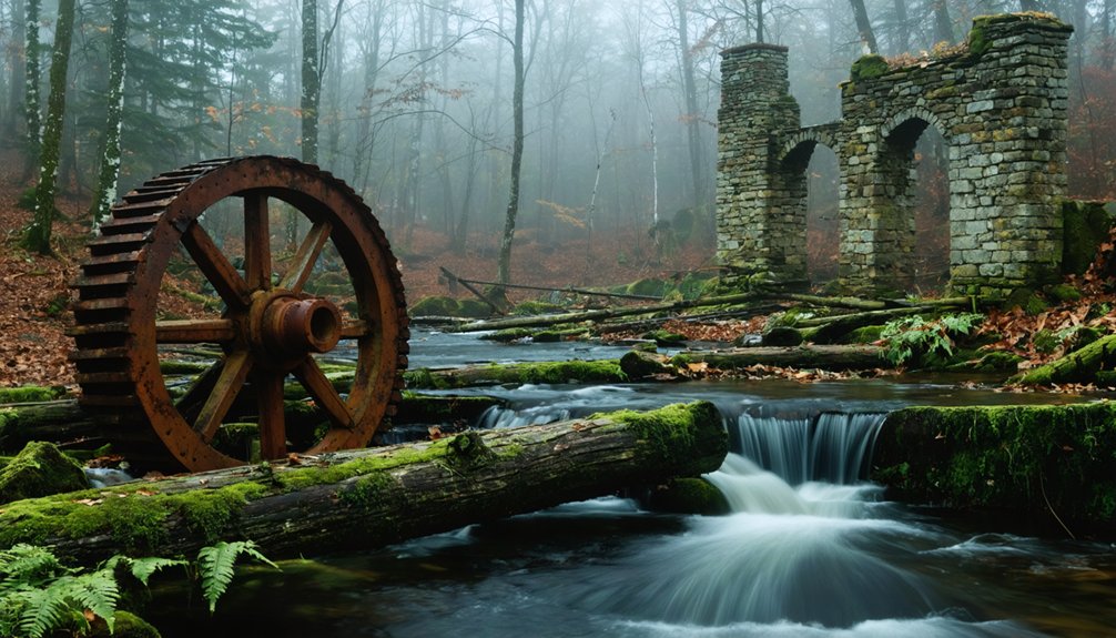
The logging history here runs deep—230 workers once produced 100,000 wooden bobbins daily at what became the world’s largest bobbin mill.
Twenty-five miles of railroad track snaked through virgin forest to feed the operation between 1917 and 1924.
Rails carved through untouched wilderness, hauling timber to feed the world’s largest bobbin mill for seven years.
You can still trace the old railroad bed if you know where to look, though nature’s reclaimed most of it.
The mill remnants disappeared long ago, and the steel rails were melted down for World War II.
What remains is wilderness—the same Black Mountain watershed that drew loggers here, now regenerated and protected within White Mountain National Forest. The model utopian village built in 1917 included 18 houses with modern amenities like electricity and running water, plus a boarding house, general store, and school.
The operation utilized Shay locomotives to haul timber along tracks that featured numerous trestles and a dramatic hairpin turn called the Horseshoe near Camp 9.
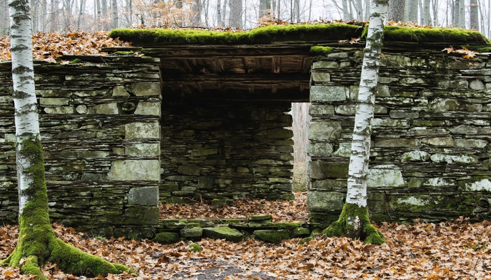
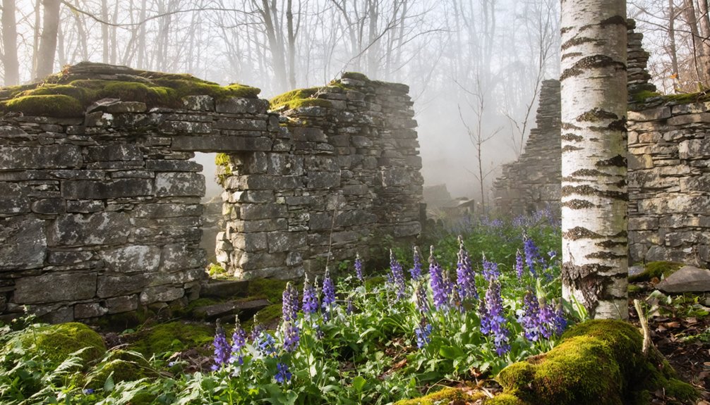
Livermore: New Hampshire’s Smallest Town With a Forgotten Past
How does a town that once housed nearly 200 people simply vanish from the map? You’ll find Livermore’s answer scattered through the forest—crumbling foundations where the Grafton County Lumber Co.’s sawmill once roared, processing spruce and fir that fueled New England’s expansion.
Walk these trails west of Bartlett, and you’re stepping through community stories etched in stone and ruin. The 1880s boom brought $150,000 in investments, an eight-mile railroad, schools buzzing with children.
Then smallpox struck in 1880. Fire consumed the mill in 1919. The devastating 1927 flood finished what nature started.
Today, historical preservation battles time itself here. Two residents remain in this unincorporated township.
The schoolhouse, powerhouse, and store foundations stand as archaeological monuments to freedom-seekers who built empires in wilderness—then watched them disappear. Inside the store’s cellar hole, you’ll still find the original large cast-iron safe, a silent witness to commerce that once thrived here. The site shares its name with multiple other Livermores, appearing on Wikipedia’s disambiguation page alongside various places and people bearing the same title.
Zealand: The Ghost Town Destroyed by Forest Fires
James Everell Henry built his lumber empire in Zealand Valley during the 1880s, carving an entire company town from the wilderness to strip millions of acres of virgin White Mountain forest.
You’ll find the trailhead to Zealand Falls off Route 302 near Twin Mountain, where the old railroad bed now serves as your gateway into this ghost town’s haunting remains.
The path follows Henry’s former logging railroad route, passing cellar holes and charcoal kilns that stand as silent witnesses to the 1897 fire that consumed everything he’d built.
A historical marker commemorates Zealand’s rise and fall, honoring the town’s connection to the lumber industry that once thrived here.
Along the trail, you’ll discover old logging trestles on the north bank, remnants of the railroad infrastructure that once transported timber from these mountains.
James Everell Henry’s Lumber Operations
His company town ran like clockwork under strict rules. Workers faced fines for wasting food or talking too loudly at tables.
By 1897, the valley stood bare—every marketable tree cut, processed, shipped. Henry simply dismantled everything: buildings, rails, lives.
This town abandonment wasn’t gradual; he relocated entire structures to Lincoln, leaving Zealand to forest fires and memory. The 1897 fire destroyed the station and other key structures, marking the beginning of the end. Today, beaver ponds cover the old rail beds where lumber operations once thrived.
Accessing Zealand Falls Trail
Today’s Zealand Falls Trail begins where Henry’s company town once thrived, though you’d never guess it from the peaceful forest that greets you at the trailhead. You’ll find the parking area off Zealand Road at coordinates 44.2662, -71.4883, just a short drive from Route 302.
Trail conditions remain gentle throughout this easy two-hour round-trip hike.
Spring brings variable seasonal accessibility—snowmelt transforms sections into muddy passages, while beaver ponds now flood portions of the old railroad bed.
Summer and fall offer more predictable footing.
As you walk toward Zealand Falls Hut, watch for cellar holes north of the path and the granite railroad underpass that once carried logging trains. The settlement earned recognition among New Hampshire’s documented ghost towns, appearing in white mountain history archives dating back to 2010. The forest has reclaimed what fire destroyed, leaving only stone foundations as whispers of 250 residents who called this wilderness home.
Exploring further, you’ll find other ghost towns located in New Hampshire, each with its own story of prosperity and decline. These remnants of past communities are often hidden beneath layers of nature, inviting adventurers to uncover their mysteries. As you delve into these forgotten places, you may stumble upon artifacts from eras gone by, echoing tales of life in the mountains.
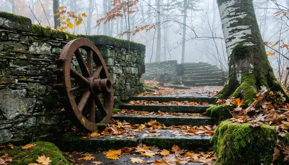
Old Hill Village: Submerged Beneath Franklin Falls Reservoir
When spring meltwater transforms Franklin Falls Reservoir from a quiet riverbed into a vast expanse of water, you’re witnessing the seasonal resurrection of Old Hill Village—a community that chose survival over surrender.
Rather than disband for the 1937 dam project, residents relocated their entire town westward by 1941, moving 30 houses, schools, and infrastructure to higher ground. Only 14 buildings from the original village were actually preserved during this ambitious relocation effort.
You can explore this historical landmark through urban exploration adventures accessible spring through fall:
- Hiking trails follow original Main Street through visible foundations
- Historical plaques mark where buildings once stood
- Spring floods reveal high-water marks annually
- Old mill foundations showcase the 1872 latch-needle factory
Visit the first weekend after Labor Day when vehicular access opens, or trek in earlier for authentic ghost-town discovery.
Monson Center: Colonial Ruins With an Eerie Atmosphere
Wandering through Monson Center’s 2.5 miles of trails, you’ll discover stone foundations from the 1730s half-hidden beneath mountain laurel and moss-covered walls.
The preserved cellar holes of the Bailey, Hubbard, and Gould families mark where New Hampshire’s first inland colony once thrived before its complete abandonment in 1770.
Many visitors report an unsettling energy among these ruins—perhaps the lingering presence of settlers who couldn’t coax life from this barren, unyielding land.
Preserved 1700s Building Foundations
Deep in the woods straddling Hollis and Milford, stone-lined cellar holes sink into the forest floor like open graves from another century. You’ll find the foundations of Monson Center’s 1730s settlement scattered across 200 acres—each depression marked with signs revealing the families who once called this failed colony home.
The architectural archaeology here tells stories conventional museums can’t. Through historical reconstruction, you’ll discover:
- Sunken cellar holes along old East and West Monson Roads
- Crumbling stone walls threading through overgrown forests
- The restored 1756 Gould House with period furnishings
- Labeled homestead sites with genealogical histories
Maps at the Gould House entrance guide you to specific family plots, though sparse signage means you’re free to wander and stumble upon ruins yourself—getting authentically lost among colonial ghosts.
2.5 Miles of Trails
The ruins don’t reveal themselves easily—you’ll walk roughly 2.3 miles out-and-back across the 269-acre conservation property to find them, though you can customize loops that stretch beyond 3 miles if the colonial detective work grips you.
Wide former village roads like East Monson Road and West Monson Road guide you through open fields and mountain laurel groves toward cellar holes marked with interpretive signs.
Each homestead site—the Brown cellar hole, the Hubbard home foundation—tells its settler family’s story through historical architecture fragments: stone walls, crumbling foundations, and the ghosts of 1700s communities.
Conservation efforts by the Forest Society have preserved these woodland trails for snowshoeing, cross-country skiing, and spring wildflower hunts, ensuring you can wander freely through New Hampshire’s abandoned past.
Reported Paranormal Energy
Caretaker Russ Dickerman once showed visitors a photograph he’d taken near the Gould House—a curious image where something resembling a ghostly figure appeared reflected in the glass, prompting whispered speculation about Monson Center’s spectral residents.
While no formal hauntings are documented, the site’s historical folklore naturally fuels imagination:
- The Bailey family’s devastating house fire, recounted on weathered plaques
- Sudden 1770 abandonment leaving homes mid-life, creating unresolved energy
- Silent woods amplifying every footstep through forgotten cellar holes
- Mormon exodus stories adding layers to dramatic settlement failures
You won’t find ghost tours or manufactured scares here—just authentic colonial ruins where spectral sightings feel plausible amid stone foundations and overgrown pathways.
The eerie atmosphere speaks for itself, letting you draw your own conclusions about what lingers in these preserved woods.
East Weare: A Village Lost to Changing Travel Routes
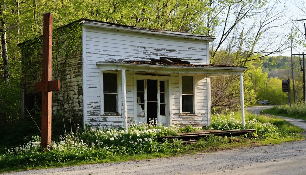
Before changing travel routes sealed its fate, East Weare thrived as a bustling village of over 60 farming families who worked the land and harvested timber from surrounding forests.
East Weare once flourished with over 60 farming families cultivating the land and logging the dense surrounding forests.
You’ll find Historical Marker No. 143 marking where this community once stood, though the 1938 hurricane’s destruction of Weare Dam foreshadowed worse devastation ahead.
In 1960, the federal government flooded the village for the Everett Flood Control Project, posting condemned notices on occupied homes before contractors dismantled or burned structures.
Today, you can explore the abandoned infrastructure—foundation remnants peek through river water while Boy Scout granite markers identify original sites.
The historical geology reveals itself through broken foundations, old walking paths, and ghostly outlines where toy shops and doctor’s offices once served this forgotten hamlet.
Frequently Asked Questions
What Safety Precautions Should Visitors Take When Exploring Abandoned Ghost Towns?
Like Indiana Jones steering through ancient ruins, you’ll need to watch for potential hazards—rotting floors, unstable structures, and toxic contaminants. Respect historical preservation by obtaining permission, packing safety gear, and leaving artifacts untouched during your adventure.
Are There Guided Tours Available for New Hampshire’s Ghost Towns?
You’ll find guided tours exploring historical ghost sites in Portsmouth, where experts like Roxie Zwicker share ghost town legends through cobblestone streets. These atmospheric walks reveal Revolutionary War echoes, burial grounds, and haunted taverns where restless spirits still linger today.
Can Visitors Camp Overnight Near These Ghost Town Sites in Spring?
You’ll find “rustic accommodations” near hidden history sites like Tripoli Road Campground ($25/night, mid-May opening) and Lost River Valley with full hookups. Dispersed camping works in White Mountain National Forest areas, letting you explore scenic landscapes freely at dawn.
What Photography Equipment Works Best for Capturing Ghost Town Ruins?
You’ll want a wide-angle lens like Sony’s 16-35mm f/2.8 for historical preservation shots, plus a sturdy tripod for stability. Don’t forget a headlamp for urban exploration—these forgotten spaces reward your adventurous spirit with incredible photographic freedom.
Are Any Ghost Towns on Private Property Requiring Permission to Visit?
Don’t jump the gun—yes, Livermore sits on Shackford family land with access restrictions requiring property permissions. You’ll need their okay before exploring. Instead, check out publicly accessible alternatives like Monson Center, where freedom-loving adventurers roam without barriers.
References
- https://kids.kiddle.co/List_of_ghost_towns_in_New_Hampshire
- https://www.onlyinyourstate.com/experiences/new-hampshire/ghost-towns-nh
- https://www.nhmagazine.com/the-most-haunted-places-in-new-hampshire/
- https://wjbq.com/abandoned-ghost-town-of-livermore-is-new-hampshires-smallest-town/
- https://vitabrevis.americanancestors.org/2016/11/new-hampshire-ghost-town
- https://www.whitemountainhistory.org/abandoned-towns
- https://www.visitwhitemountains.com/blog/post/spooky-stories-ghost-towns-and-historic-haunted-spots/
- https://freepages.history.rootsweb.com/~gtusa/usa/nh.htm
- https://www.laconiadailysun.com/community/outdoors/following-the-beebe-river/article_5ddcc012-92a7-11e9-a3b2-5bee7698d29f.html
- https://www.scenicnh.com/blog/2018/04/beebe-river-railroad/