You’ll find authentic ghost towns preserved by the National Park Service at multiple sites, including Death Valley’s Rhyolite with its impressive bank building ruins, Blue Heron’s coal mining settlement at Big South Fork, and the massive Kennecott copper mines in Alaska. These abandoned communities from America’s mining and industrial eras remain frozen in time, with the NPS maintaining structures and artifacts while providing free public access. Each location offers documented evidence of the economic forces that built and ultimately destroyed these once-thriving settlements.
Key Takeaways
- Blue Heron ghost town at Big South Fork preserves a 1937 coal mining company settlement abandoned in 1962.
- Rhyolite in Death Valley features accessible ruins from a 1904 gold rush town that collapsed after 1907.
- Death Valley manages multiple ghost towns including Panamint City, Skidoo, and Leadfield from various mining eras.
- Sutro Baths ruins within Golden Gate National Recreation Area remain accessible year-round with free admission.
- Kennecott Mines in Alaska preserves early 20th-century copper mining operations producing $200 million in ore.
Big South Fork National River and Recreation Area’s Coal Mining Settlement
When the Stearns Coal and Lumber Company established Mine 18 in 1937 along the Big South Fork River, it created what would become known as Blue Heron—a coal mining settlement that housed hundreds of workers and their families in one of the region’s most isolated communities.
This coal mining history reveals a self-contained company town where Stearns controlled every aspect of community life: the mines, railroad, houses, store, and school. Workers received scrip instead of cash, binding them to the company’s economic system.
You’ll find the settlement operated until December 1962, when declining profitability forced closure. The Big South Fork Scenic Railway now departs from Stearns Depot and travels to this historic site, providing scenic views of the river gorge.
Today, the National Park Service preserves this site through ghost structures—open metal frameworks positioned on original foundations—allowing you to experience the settlement’s layout while oral histories document the voices of those who lived here. Each structure includes audio programs and exhibits that share memories from former residents alongside photographs and everyday items from the community.
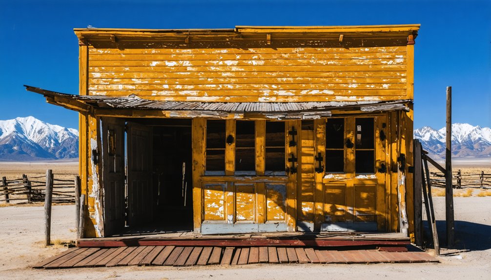
Rhyolite and Other Ghost Towns of Death Valley National Park
You’ll find Rhyolite’s remnants 35 miles east of Furnace Creek, where Shorty Harris and E.L. Cross’s 1904 gold discovery sparked a settlement that swelled to thousands within four years before collapsing by 1911.
The Bureau of Land Management maintains these ruins—including the three-story bank walls, jail, and Paramount Pictures-restored Bottle House—offering free sunrise-to-sunset access to one of the West’s most documented ghost towns.
Death Valley National Park’s eastern boundary encompasses this and other mining settlements that preserve the region’s brief but intensive extraction history.
The town once supported over 2,000 mining claims along with a stock exchange, hotels, schools, and an opera house during its peak prosperity.
The Montgomery Shoshone mine served as the district’s most promising operation and primary draw for settlers rushing to the Bullfrog district.
Rhyolite’s Gold Rush History
Although the Bullfrog Mining District encompassed over 2,000 claims across a 30-mile area, Rhyolite’s origins trace to a single discovery in 1904. Prospectors Shorty Harris and E.L. Cross found gold-bearing quartz veins in the surrounding hills, establishing the “Bullfrog” claim.
Rhyolite mining operations exploded, attracting 5,000 residents within six months.
The town’s infrastructure demonstrated remarkable ambition:
- A $90,000 three-story bank building (now iconic ghost town architecture)
- Stock exchange and Board of Trade for managing investments
- Municipal services including schools, hospitals, opera house, and electric plants
Peak population reached 10,000 before the 1907 financial panic triggered collapse. The 1906 San Francisco earthquake further complicated capital raising efforts, hampering investment in mining operations during a critical growth period. Steel magnate Charles M. Schwab purchased the Bullfrog Mining District in 1906, bringing modern amenities and three railroad lines to the booming town.
Exploring Death Valley’s Ghost Towns
Beyond Rhyolite’s well-preserved ruins, Death Valley National Park encompasses numerous ghost towns that document the region’s volatile mining history from the 1870s through the early 1900s.
Among these are the ghost towns around Black Canyon, which offer a glimpse into the lives of those who sought fortune during the gold rush. Exploring these abandoned settlements provides a fascinating contrast to the stark beauty of the surrounding desert landscape. Visitors can wander through the remnants of old buildings and imagine the bustling activity that once filled these now-silent streets.
Your ghost town exploration can include Panamint City, which housed 2,000 residents during its 1874 peak, featuring seven saloons and a Wells Fargo office.
You’ll find Skidoo’s milling plant ruins, founded in 1906 after gold discoveries drew 700 inhabitants.
Chloride City emerged following the 1905 Bullfrog strike but became abandoned by 1906, leaving mining adts and stamp mill remains.
Darwin maintains 36-43 residents operating folk art stores, while Ballarat displays adobe ruins on private land.
Greenwater left no visible structures despite housing 2,000 residents during its 1905 copper strike, exemplifying the region’s boom-and-bust mining history.
The economic panic of 1907 triggered widespread abandonment across Death Valley’s mining communities as investment capital dried up and ore prices collapsed.
Leadfield was abandoned by early 1927, just months after its post office established in 1926, following founder Charles Julian’s misleading advertising campaign for copper and lead mining prospects.
Accessing Remote Abandoned Sites
While Death Valley‘s interior ghost towns require backcountry navigation skills, Rhyolite stands apart as the region’s most accessible abandoned settlement.
Located just 4 miles west of Beatty on Highway 374, you’ll find year-round access via paved roads suitable for any vehicle. The Bureau of Land Management maintains free public access from sunrise to sunset, making remote exploration straightforward.
Your route options include:
- From Las Vegas: Highway 95 north to Beatty, then Highway 374 westbound (120 miles total)
- From Furnace Creek: 35-mile journey east on Highway 374 (30-minute drive)
- Best visiting season: October through May for ideal conditions
You’ll discover exceptional abandoned structures here—the three-story Cook Bank Building, restored Bottle House, intact jailhouse, and railroad depot—all positioned at 3,800 feet elevation with unrestricted access. The town’s namesake reflects the light-colored rhyolitic rock formations found throughout the surrounding landscape, typical of this region’s volcanic geology.
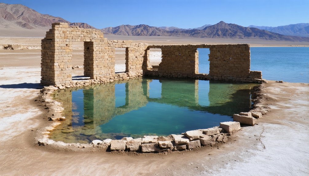
Sutro Baths at Golden Gate National Recreation Area
The Sutro Baths ruins represent one of San Francisco’s most ambitious recreational ventures, where Adolph Sutro’s elaborate saltwater complex once accommodated up to 10,000 visitors daily before fire destroyed the structure in 1966.
You’ll find these concrete remnants preserved within Golden Gate National Recreation Area‘s Sutro Historic District, where the National Park Service has maintained the site since 1973.
Access to the ruins is available through walking trails from the Merrie Way parking area, allowing you to examine the remaining foundations and pools that once formed this architectural marvel. The original facility featured seven heated pools that were fed by seawater from the Pacific Ocean.
History of Sutro Baths
During San Francisco’s Gilded Age expansion, self-made millionaire and former mayor Adolph Sutro (1895–1897) initiated planning for the Sutro Baths in 1888, offering a $500 prize for architectural design.
Architects C.J. Colley and Emil S. Lemme won with their architectural innovation featuring seven heated saltwater pools beneath 100,000 square feet of glass.
Construction began in 1894, and the facility opened March 14, 1896. The complex offered unprecedented public amenities:
- 10,000-person capacity with 517 private dressing rooms
- Tidal flushing system eliminating traditional pumping needs
- Museum displaying Egyptian mummies and international artifacts
Despite Sutro’s vision for accessible public recreation, operational costs proved insurmountable.
After his death, heirs unsuccessfully attempted selling to San Francisco. George Whitney purchased the Sutro Baths in 1952 for $250,000, closing them permanently in 1966.
Exploring the Ruins Today
Today’s visitors encounter a stark transformation of Sutro’s ambitious recreational palace. The concrete ruins sprawl across a small beach inlet north of Cliff House, where skeletal foundations of the original three-acre structure cling to rocks below Lands End.
You’ll find blocked-off stairs, crumbling passageways, and faint outlines of seven massive saltwater pools integrated into the cove. A man-made seawall stretches across the bottom as Pacific waves crash overhead.
The National Park Service preserves these coastal ruins within the Golden Gate National Recreation Area, maintaining their raw state without interpretive services.
Trails from Merrie Way parking area lead you down to explore the remnants. Here, amid ducks and cormorants, you’ll discover the foundations of a 100,000-square-foot glass-enclosed facility that once welcomed 25,000 people.
Visiting Guidelines and Access
Unlike many historic sites requiring paid admission, Sutro Baths remains freely accessible year-round as part of Golden Gate National Recreation Area.
You’ll find no entrance fees or passes required for exploring these coastal ruins. Visitor hours operate 24/7 at the ruins themselves, though parking availability runs sunrise to sunset at 680 Point Lobos Avenue.
Essential Access Information:
- Transit Options: MUNI lines 38, 38AX, and 38R stop at 48th Avenue & Point Lobos Avenue, providing direct service from San Francisco neighborhoods.
- Pet Policy: You’re permitted to bring leashed dogs throughout the ruins area.
- Safety Protocols: Watch for posted warnings regarding large waves and tidal changes along the shoreline.
For guided tours through Parks Conservancy or additional information, contact Lands End Lookout at (415) 426-5240.
Klondike Gold Rush National Historical Park’s Mining Remnants
The Klondike Gold Rush National Historical Park preserves extensive physical evidence of mining operations that transformed the Yukon Territory following the 1896 discovery of gold on Bonanza Creek.
You’ll find intact mining equipment throughout the park, including the towering Dredge No. 4—an 8-story structure that once extracted nearly 800 ounces of gold daily.
At Discovery Claim, you can experience gold panning at the original strike location.
Archaeological surveys have documented approximately 4,000 artifacts in stratified deposits, alongside tram hardware and knock-down boat supplies abandoned by prospectors.
The park’s Alaska and Seattle locations archive these remnants without romantic embellishment, presenting raw evidence of the extraction industry that peaked in 1903 and yielded an estimated $500 million in gold.
St. Thomas Ghost Town at Lake Mead National Recreation Area
Founded on January 8, 1865, by Mormon settlers, St. Thomas thrived as an Arrowhead Trail stop between Los Angeles and Salt Lake City until Hoover Dam‘s construction forced its abandonment in 1938.
This site represents unique underwater archaeology, as Lake Mead submerged it beneath 50-70 feet of water for decades before drought exposed it permanently since 2003.
You’ll find concrete foundations along old streets at the northern end of Lake Mead National Recreation Area.
Access requires:
- Driving NV-169 south from Overton approximately 9 miles
- Following 3.5 miles of graded dirt road
- Hiking a 2.3-mile loop trail from the trailhead
Historic preservation efforts include interpretive signs documenting the town’s layout.
You’ll need sturdy footwear and water for this flat hike through salt-encrusted remnants.
Federal regulations prohibit artifact collection.
Kennecott Mines at Wrangell-St. Elias National Park and Preserve
Perched at 5,280 feet elevation on the edge of Kennicott Glacier, this National Historic Landmark represents the most complete example of early 20th-century copper mining operations in North America.
You’ll find evidence of Kennecott history dating to 1900, when prospectors discovered 70% pure chalcocite ore. The Guggenheim-Morgan Alaska Syndicate invested $25 million constructing a 196-mile railroad from Cordova between 1907-1911.
From 1911-1938, operations produced $200 million worth of copper from 4.5 million tons of ore, employing 500-600 workers at peak capacity. The National Park Service acquired the site in 1998, stabilizing structures rather than restoring them.
You can access this remote 7,700-acre district via McCarthy Road, exploring preserved mining technology and infrastructure within America’s largest national park.
Planning Your Ghost Town Visit to National Park Sites

Before starting your ghost town exploration, you’ll need to evaluate access requirements that vary dramatically across National Park Service sites.
Additionally, exploring ghost towns in California can reveal fascinating histories and unique architectural remnants. Be sure to research each location’s hours of operation and any specific guidelines to ensure a safe and enjoyable visit. Many of these sites provide insights into the lives of those who once inhabited these now-abandoned areas.
Remote locations like Chisana and Bremner demand mandatory air taxi reservations through permitted operators, while sites near Death Valley and Great Smoky Mountains require only park entry fees without advance bookings.
Essential Planning Steps:
- Research site-specific access methods—Rhyolite offers 45-minute drives from Furnace Creek, while Custer requires hiking through Salmon-Challis National Forest.
- Book fixed-wing flights weeks ahead for Wrangell-St. Elias ghost town photography expeditions.
- Verify current preservation status and visitor safety protocols at your chosen destination.
Elkmont’s 60 vacant buildings and Rush’s zinc mining remnants present unique documentation opportunities once you’ve secured proper access arrangements.
Frequently Asked Questions
Are Overnight Stays Allowed at Any National Park Ghost Town Sites?
Yes, you’ll find overnight camping permitted at Chaco Culture National Historical Park’s ghost town sites. However, you must follow specific camping regulations and obtain overnight permits through the park’s designated campground facilities under dark sky preservation guidelines.
Can Visitors Enter the Abandoned Buildings or Are They Off-Limits?
Access varies by site—you’ll find some abandoned architecture open for exploration while others remain off-limits due to structural instability or historical significance requiring preservation. Always check park-specific regulations before entering any structures.
Are Guided Tours Available or Must Ghost Towns Be Explored Independently?
You’ll find both options available. Kennicott, Bannack, and Elkmont offer guided exploration through authorized tours, while self-guided tours allow independent discovery at Kennicott, Grafton, and Bannack using provided maps and interpretive signage.
What Safety Hazards Should Visitors Watch for at Ghost Town Sites?
You’ll encounter unstable structures with rotting timbers and hidden shafts, toxic contaminants in soil and water, unprotected vertical drops, wildlife encounters including rattlesnakes and mountain lions, and extreme heat exposure requiring constant vigilance while exploring independently.
Are Ghost Towns Accessible Year-Round or Do Seasonal Closures Apply?
Accessibility varies considerably—you’ll find Rhyolite welcomes year-round exploration, while Thurmond’s depot closes winters. Seasonal weather and accessibility challenges affect Rush and Keys Ranch differently, with guided tours limiting spontaneous visits throughout changing conditions.
References
- https://www.nps.gov/subjects/abandonedplaces/visit.htm
- https://albiongould.com/ghost-towns-to-visit-in-the-states/
- https://www.npca.org/articles/1935-spooky-beautiful-photos-of-abandoned-park-towns
- https://www.loveexploring.com/gallerylist/66971/frozen-in-time-the-worlds-most-fascinating-ghost-towns
- https://www.thedearbobandsuepodcast.com/139-ghost-towns-of-the-national-parks/
- https://whakestudios.com/us-ghost-towns/
- https://www.atlasobscura.com/lists/americas-best-preserved-ghost-towns
- https://www.nps.gov/subjects/abandonedplaces/ghost-towns.htm
- https://www.nps.gov/biso/learn/historyculture/blueheron.htm
- https://eec.ky.gov/Natural-Resources/Mining/Abandoned-Mine-Lands/projects/Pages/Big_South_Fork.aspx


