You’ll find Riceville, an 1879 tannery town in Hancock County’s Township 39, just miles from Acadia—abandoned after its buffalo-hide processing facility burned in 1905. Flagstaff Lake conceals four flooded villages beneath its waters since 1950, while Perkins Township on Swan Island became uninhabited after shipbuilding and ice harvesting collapsed in 1918. Freeman Township persists as an unorganized territory at 919 feet elevation, its population scattered after Franklin County’s 1838 formation divided its lands. Each site preserves cellar holes, stone foundations, and cemetery markers documenting Maine’s economic transformations that you can explore throughout this thorough guide.
Key Takeaways
- Riceville in Hancock County, founded in 1879, was abandoned by 1910 after its tannery burned down in 1905.
- Riceville’s tannery processed buffalo hides for New England’s shoe industry, supporting over 75 residents by 1900.
- The ghost town lies in Township 39, the same county as Acadia National Park.
- Only traces of Riceville’s industrial past remain, including foundations from the former tannery operations.
- Maine ghost towns typically formed when economic anchors collapsed, leaving behind cellar holes and stone foundations.
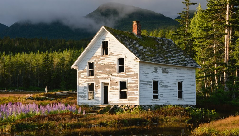
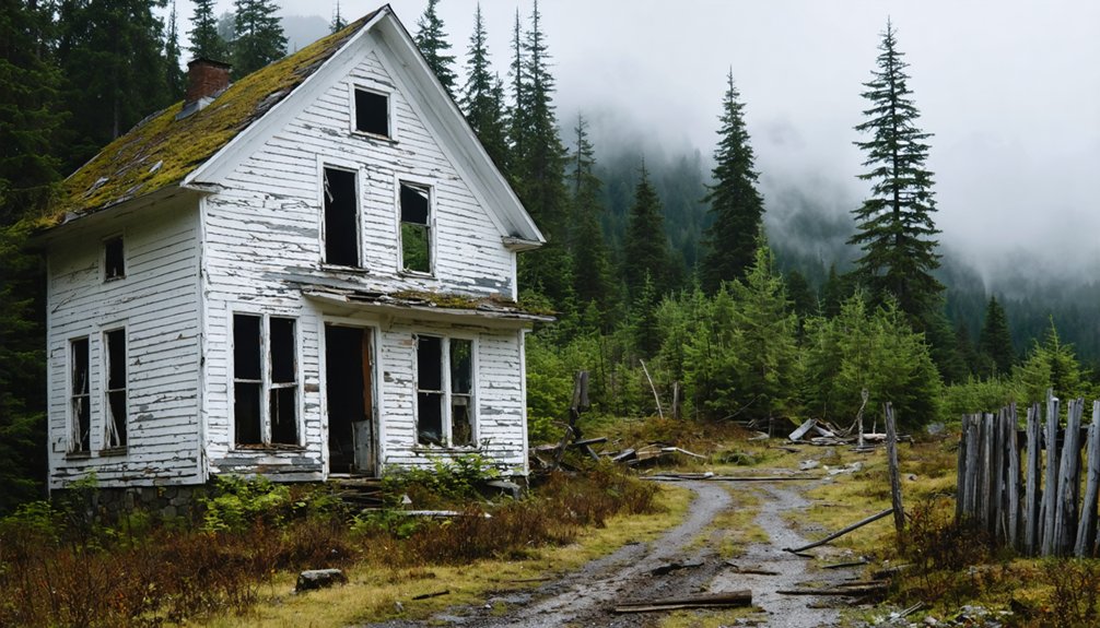
Riceville: Hancock County’s Abandoned Township 39
Deep in Township 39 of Hancock County, the Shaw brothers carved Riceville from Maine wilderness in 1879, anchoring their settlement with a tannery that would define the community’s brief existence.
When the Shaws failed, Buzzell and Rice purchased the facility in the 1880s, expanding tannery operations to process buffalo hides for New England’s shoe industry. By 1900, over 75 residents called Riceville home, their livelihoods entirely dependent on leather production. The community’s clean water and isolation made it ideal for tanning operations.
Riceville history ended abruptly when fire consumed the tannery between December 30-31, 1905. Despite insurance coverage, owners chose not to rebuild. The post office closed in 1906, and you’ll find no residents listed in the 1910 census. The township became abandoned by 1910, leaving behind only traces of its industrial past.
Today, you can explore cellar holes and overgrown foundations—all that remains of this industrial ghost town.
As you delve deeper into this historical landscape, you might even encounter unique artifacts buried beneath the soil. For those seeking excitement, metal detecting adventures in Nevada offer the chance to uncover hidden treasures from the past. Each find tells a story, connecting you to a time when this area thrived with life and industry.
The Submerged Settlement of Flagstaff Lake
If you’d driven through Somerset County in 1949, you’d have found Flagstaff Village, Dead River Village, Bigelow, and Carrying Place clustered along the Dead River floodplain—settlements that’d thrived since the 1800s.
Central Maine Power shut the gates at Long Falls Dam in 1950, sending water over farms, homes, and the mill at Mill Stream.
Today, Flagstaff Lake stretches across twenty square miles where those communities once stood, its waters concealing stone foundations that surface only when reservoir levels drop. The lake now ranks as Maine’s fourth-largest, extending approximately 27 miles through the northwestern mountains. Visitors flock to the lake for summer activities and snowmobiling, unaware of the ghost town resting beneath the surface.
Creation of the Reservoir
When Central Maine Power began purchasing land around Flagstaff in 1930, residents didn’t yet know their communities would vanish beneath water within two decades. Walter Wyman’s consolidation of small power companies drove the hydroelectric ambitions.
After legislator Percival Baxter blocked initial plans at The Forks, CMP selected Long Falls on Dead River for their dam site.
Crews arrived in 1948 to clear the flowage area. By summer 1949, smoke from burning brush engulfed Flagstaff as homes and barns were dismantled.
The Dead River was diverted that fall, and Long Falls Dam‘s gates shut in 1950. This reservoir formation created Maine’s largest man-made lake—a 20-square-mile reservoir holding spring runoff. The project served dual purposes: meeting the state’s electrical power demands and providing flood control for the lower Kennebec River.
The flooding impact erased four villages, though stone foundations still surface when water levels drop. Some houses were sold back to families who relocated them to higher ground, while many former residents settled in nearby Eustis.
What Remains Today
Beneath Flagstaff Lake’s surface lies a ghost town that refuses to stay hidden. When you visit during water drawdowns, you’ll spot stone foundations marking where families once lived. Those lake remnants tell stories—farm structures emerge from the depths, and you can still see the big farm that stood before town.
Little houses once lined the left side near what’s now shoreline.
You’ll find this submerged history extends beyond the water. The schoolhouse stands relocated on higher ground, while church windows grace their new home. Gravestones from Flagstaff Cemetery rest in Eustis, and Dead River Cemetery’s remains were transferred with care. Former residents like June Parsons and Betty Wyman still hold memories of childhood homes that now rest beneath the water’s surface.
Today’s pontoon-boat tours let you explore twenty square miles of Maine’s largest man-made lake, where guides use hand-drawn maps to show you exactly where buildings stood before 1950’s flooding. The area’s transformation began when a dam flooded small villages, creating the reservoir that now generates hydroelectric power.
Freeman Township: Franklin County’s Depopulated Area
Though Freeman Township traces its origins to the 1767 burning of Falmouth—modern-day Portland—its transformation into Franklin County’s depopulated terrain unfolded over two centuries.
You’ll find Freeman history beginning when sufferers received land grants around 1797 in what they called Little River, formerly Township No. 3 Range 2 W.K.R. The burning of Falmouth prompted colonial authorities to grant survivors two townships of land as compensation.
Township evolution reveals dramatic population shifts. Freeman appeared larger in the 1820 Somerset County census than today’s boundaries suggest. The 1820 Census documented Freeman alongside neighboring Strong and other Franklin County settlements.
Freeman’s territorial reach in 1820 exceeded its modern footprint—boundaries that would contract as settlers subdivided the original township.
When residents carved out North Salem (now Salem Township) in 1823, the territory shrank. By Franklin County’s 1838 formation from Kennebec, Oxford, and Somerset lands, Freeman’s decline had begun.
Today you’re exploring unorganized territory at 919 feet elevation—a depopulated area where early settlers’ aspirations faded into East Central Franklin’s wilderness.
Perkins Township and Swan Island’s Forgotten Past
You’ll find Perkins Township’s story etched into Swan Island, where Captain James Whidden established the first permanent settlement in 1750, though archaeological evidence reveals Abenaki camps dating back 9,000 years.
The township incorporated in 1847 through Thomas Handasyd Perkins’s financial backing, then thrived on shipbuilding and ice harvesting until pollution and economic collapse forced disincorporation in 1918.
Maine’s Department of Inland Fisheries and Wildlife now manages the 1,500-acre site as the Steve Powell Wildlife Management Area, accessible only by ferry from Richmond or Dresden between May and October.
Historical Settlement and Decline
Long before tourists discovered the coastal beauty near Acadia, English settlers established roots on Swan Island in the mid-1700s, building atop land where the Kennebec tribe had maintained summer hunting camps for centuries.
These settlement patterns altered 1,500 acres of river territory into the Town of Perkins by mid-19th century, peaking near 100 residents.
Economic changes decimated this river community through:
- Modern refrigeration ending ice harvesting in early 1900s
- Iron ships replacing wooden vessels, killing shipbuilding trade
- Kennebec River pollution destroying fishing livelihoods
- Great Depression forcing mass abandonment of farmland
You’ll find the island uninhabited since the mid-1940s.
Insufficient men remained for town offices by 1918, forcing disincorporation.
The Richmond-Swan Island-Dresden ferry’s 1936 closure sealed Perkins Township’s fate as Maine’s forgotten ghost town.
State Management and Preservation
After the last residents departed, Maine’s Department of Inland Fisheries and Wildlife stepped in to acquire the abandoned farmsteads throughout the 1940s and early 1950s. The state oversight transformed Swan Island from unorganized territory into a Wildlife Management Area, ending local governance that’d existed since 1847.
IF&W’s wildlife management approach preserved historic land patterns while prioritizing waterfowl habitat in Merrymeeting Bay. You’ll find bald eagle nests, deer, turkey, and grouse populations thriving under protective regulations. The entire island earned National Register status, safeguarding five period houses, three ice houses, and remnants of shipbuilding operations.
Yet this preservation comes with burdens—empty buildings face Maine’s harsh climate without regular maintenance. The department balances cultural heritage against practical wildlife habitat needs across forests, fields, and riverbanks.
Accessing the Remote Island
Reaching Swan Island requires advance planning since the Maine Department of Inland Fisheries & Wildlife controls the only access point through seasonal ferry service from Richmond.
You’ll need to reserve passage months ahead during peak summer months when day-trippers and overnight campers explore this abandoned settlement’s historical significance.
What you’ll encounter upon landing:
- Over 20 cellar holes marking former homesteads from Perkins’s 1860 peak population
- Curtis Cemetery’s weathered headstones chronicling families who worked the ice houses and shipyards
- Overgrown roads threading through second-growth forest where farms once prospered
- Little Swan Island’s remnants accessible only by private boat during low tide
The state maintains minimal infrastructure—you’re stepping into genuine wilderness where a self-sufficient community once thrived before economic collapse drove everyone away.
Ship Harbor Trail: Acadia’s Shipwreck Legend
When George B. Dorr drafted plans for Ship Harbor Trail in the 1930s, he couldn’t have known the shipwreck tales that’d later define this remote coastline.
You’ll find the trail’s name stems from the Grand Design’s tragic fate—an English vessel carrying Irish immigrants that wrecked here in fall 1739. A 2004 archaeological study supports this connection, though proof remains elusive.
The harbor’s earned its reputation as one of Maine’s most haunted locations.
You’ll hear locals speak of cursed waters where roughly 200 souls perished in 1700s disasters. Survivors who ventured into the wilderness vanished forever.
Today, visitors report sounds of moaning and groaning along the rocky shore—haunting spirits of those who froze in these coastal conditions, their graves unmarked and forgotten.
Compass Harbor Estate Ruins and Ghostly Encounters

Just beyond Bar Harbor’s downtown bustle, the ruins of George B. Dorr’s Oldfarm estate await your discovery along Compass Harbor Trail.
Built in 1877 as a 30-room summer cottage, this property became part of Acadia National Park in 1941. Dorr, the park’s father and first superintendent, donated his 58-acre estate before his death in 1944.
Though razed in 1951, what remains tells its own story:
- Mansion foundation and ocean staircases
- Saltwater pool remnants
- Secluded beach area
- Walking paths through coastal woods
These eerie shores carry ghostly whispers of a bygone era.
You’ll find historical echoes in every crumbling step, where Dorr’s legacy meets the phantom past. Ranger-led walks reveal this forlorn estate’s secrets.
Planning Your Ghost Town Day Trip From Acadia
How best to explore Maine’s forgotten settlements while based at Acadia National Park? Start with Riceville—just 30-40 miles north via Route 3, you’ll reach this Hancock County ghost town within an hour.
Summer grants 12-14 hours of daylight for exploration, while fall delivers dramatic foliage with fewer crowds. You’ll need Acadia’s $35 entry pass if combining Ship Harbor Trail‘s shipwreck ghost town legends with your journey.
Perkins Township requires a 2.5-hour coastal drive and ferry permit to Swan Island’s historic trails. Freeman sits 80 miles inland—accessible spring through fall, but winter snow blocks passage.
Flagstaff’s haunted history lies submerged beneath the lake, viewable only by boat from Eustis. Arrive before 8 AM during peak season.
Respect private ruins; stick to marked paths where Maine’s abandoned communities whisper their stories.
What Defines a Maine Ghost Town
Maine’s ghost towns don’t conform to Hollywood’s dusty western stereotypes—they’re classified by population collapse and economic extinction rather than tumbleweeds.
You’ll recognize these settlements by their ghost town characteristics: few or no residents remaining after the economic activity sustaining them vanished.
The historical significance reveals itself through:
Maine’s ghost towns speak through cellar holes, stone walls, and submerged villages—physical echoes of communities erased by economic collapse.
- Tangible remains—cellar holes, stone walls, cemeteries, and moss-covered granite foundations
- Unorganized Territories lacking municipal government, like Perkins Township
- Dissolved towns recombined into wildlife areas after early 1900s disincorporation
- Submerged settlements such as Flagstaff Village beneath reservoir waters
Physical evidence spans 18th-century homes to overgrown burial grounds.
Natural resource exhaustion, river pollution, and the Great Depression triggered abandonment across Maine’s countryside, leaving explorable remnants of farming communities and industrial-age settlements.
Accessibility and Visiting Tips for Each Location
While most of Maine’s abandoned settlements remain inaccessible due to submersion or complete deterioration, Compass Harbor stands as the sole exception near Acadia National Park with established visitor infrastructure.
You’ll find the Compass Harbor Nature Trail leading to George Dorr’s estate ruins—skeletal stone foundations accessible year-round during daylight hours. The ghost town tourism experience here requires only standard hiking gear and independent navigation.
Flagstaff lies underwater in Somerset County’s Flagstaff Lake, offering boat-based viewing from surface level.
Freeman Township and Riceville maintain historical significance through registry documentation rather than physical sites. Perkins Township’s island location restricts access considerably.
For these locations, you’re dependent on local historical societies and archival records. No interpretive signage exists at most sites—you’ll research independently before visiting.
Frequently Asked Questions
Are There Any Legal Restrictions on Exploring Abandoned Buildings in Maine Ghost Towns?
Yes, you’ll face legal restrictions. Maine’s property laws prohibit trespassing on abandoned structures without owner permission. Urban exploration of ghost towns requires verifying ownership first, as state trespassing statutes apply regardless of a building’s condition or abandonment status.
What Photography Equipment Works Best for Documenting Ghost Town Ruins?
You’ll want a full-frame camera like the Sony Alpha 7R III with wide-angle lenses for interiors. Essential camera settings include f/9, ISO 100, and a sturdy tripod for sharp bracketed exposures in Maine’s historic ruins.
Can You Camp Overnight Near Any of These Ghost Town Locations?
You’ll find absolutely zero legal ghost town camping options—regulations ban overnight stays at all these sites. Camping’s restricted to Acadia’s designated campgrounds like Blackwoods or Seawall, requiring advance reservations twenty-plus miles away.
Which Ghost Towns Have the Most Remaining Original Structures to Explore?
Compass Harbor Ruins offers you the most substantial remains—skeletal stone foundations, massive cedars, and architectural remnants of the 30-room shingle-style Queen Anne Victorian mansion showcase significant historical architecture from Dorr family’s 1868 estate.
Are Guided Tours Available for Any Maine Ghost Towns Near Acadia?
You’ll search absolutely everywhere and find zero guided ghost town tours near Acadia. Bar Harbor operators focus strictly on haunted walks through town ruins—not abandoned settlements. Riceville and other depopulated townships remain self-guided exploration only.
References
- https://en.wikipedia.org/wiki/List_of_ghost_towns_in_Maine
- https://www.mainehauntedhouses.com/real-haunt/ship-harbor-trail.html
- http://oldmapsofacadianationalpark.blogspot.com/2019/05/real-haunted-places-in-acadia-national.html
- https://lizzie-borden.com/ghost-tours/bar-harbor/
- https://www.americanghostwalks.com/articles/hauntings-mysteries-acadia-maine
- https://b985.fm/6-maine-ghost-towns-you-never-knew-existed/
- https://www.visitbarharbor.com/list/member/american-ghost-walks-bar-harbor-81
- https://barharborstory.com/2022/08/30/the-possible-haunting-of-compass-harbor/
- https://q1065.fm/this-abandoned-estate-trail-may-be-acadias-best-kept-secret/
- http://abandonmentofmaine.weebly.com/riceville-maine.html


