You’ll find several compelling ghost towns within an hour of Arches National Park, each with its own boom-and-bust story etched into weathered stone and rusted metal. Sego Canyon, just off I-70, showcases coal mining remnants alongside ancient rock art dating to 2000 B.C. Thompson Springs and Cisco reveal the railroad era’s faded glory, while Valley City and the La Sal Mountain tent settlements of Mesa and Pinhook tell tales of failed irrigation schemes and mining rushes that vanished as quickly as they appeared, leaving only wind-scrubbed foundations and memories behind.
Key Takeaways
- Thompson Springs, a historic railroad town, is accessible via I-70 exit 187 with remnants of old motels and cafés.
- Sego Canyon ghost town features weathered stone structures, railroad trestles, and ancient rock art dating to 2000 B.C.
- Cisco became Utah’s largest oil producer in 1924 and experienced a 1950s uranium rush before Interstate 70’s construction.
- Valley City was founded in 1908 but failed after irrigation funds were mismanaged, leading settlers to relocate to Moab.
- Mesa and Pinhook were temporary tent mining communities on La Sal Mountains, now marked only by wind-scrubbed foundations.
Sego Canyon: Mining History and Ancient Rock Art
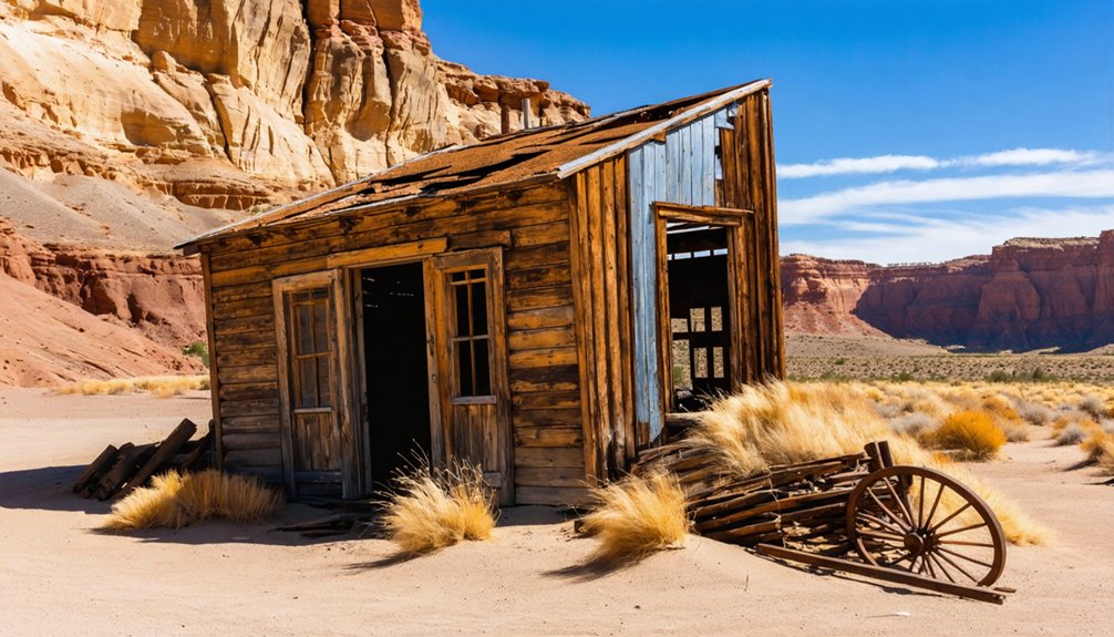
The crumbling foundations of Sego emerge from the Utah desert like broken teeth, their weathered stone and rusted metal stark against red sandstone cliffs that tower overhead.
You’ll find this ghost town where rancher Henry Ballard discovered anthracite coal in 1908, transforming Sego Canyon into a bustling industrial outpost. By 1928, mining operations churned out 1,500 tons daily with 150 men working the seams.
The company controlled everything—paying scrip instead of cash, threatening dismissal for shopping elsewhere.
When you hike deeper into the canyon, ancient pictographs reveal stories predating the mines by millennia. Barrier Style rock art features distinctive life-size mummy-like human shapes without arms or legs, dating back to approximately 2000 B.C. These weathered symbols watched European immigrants, African Americans, and Japanese laborers build their brief empire before floods, fires, and financial ruin reclaimed the land. The Denver and Rio Grande Western Railroad established a line through the canyon in the early 1900s, facilitating coal transportation that kept the mining town alive.
Cisco: A Fading Railroad Town in Grand County
- 100,000 sheep sheared annually at the turn of the century
- 1924 oil discovery made it Utah’s largest producer
- 1950s uranium rush brought thousands of prospectors
- Interstate 70’s construction in the 1970s sealed its fate
The diesel engine’s arrival eliminated the water stop’s purpose.
Cisco has appeared in films like “Thelma and Louise”, drawing photographers to its eerie landscape.
The Union Pacific Railroad still runs trains through town, though none stop anymore.
Today, sun-bleached debris and skeletal structures whisper tales of prosperity lost to progress.
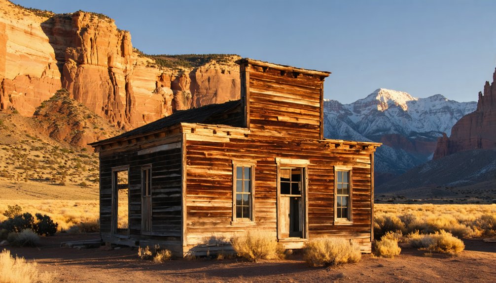
Thompson: Another Grand County Survivor
You’ll find Thompson Springs clinging to life along I-70, a weathered railroad town where the whistle of steam engines once echoed off the Book Cliffs and coal dust settled on everything.
What began as an essential shipping hub for cattle and coal in the 1880s has faded to a handful of holdouts living among abandoned motels tagged with graffiti and shuttered businesses that haven’t seen customers in decades.
The town’s story mirrors the familiar American pattern—railroad prosperity, coal boom, then the slow strangulation when interstates bypassed main streets and diesel engines replaced coal-burning locomotives. When I-70 cut through in the 1970s, it diverted traffic away from Thompson’s main street, accelerating the decline that had already begun with the mines closing. Just up Thompson Canyon Road, the nearby ghost town of Sego stands as a reminder of what complete abandonment looks like, with its collapsed buildings and foundations marking where one of Grand County’s largest towns once thrived on anthracite coal.
Historic Railroad Town Legacy
- Sheep companies shipped wool 2,000 miles to eastern factories.
- Coal miners rode the Ballard & Thompson spur from 1911 to 1950.
- Ranchers drove livestock down from Book Cliffs to waiting railcars.
- Route 50 brought new travelers seeking gas and provisions.
- The Denver and Rio Grande Railroad established a siding here in the early 1880s.
- Spring celebrations marked the sheep-shearers ball after successful seasons.
Today, you’ll still find the Desert Moon Hotel standing—proof that some desert outposts refuse to fade completely.
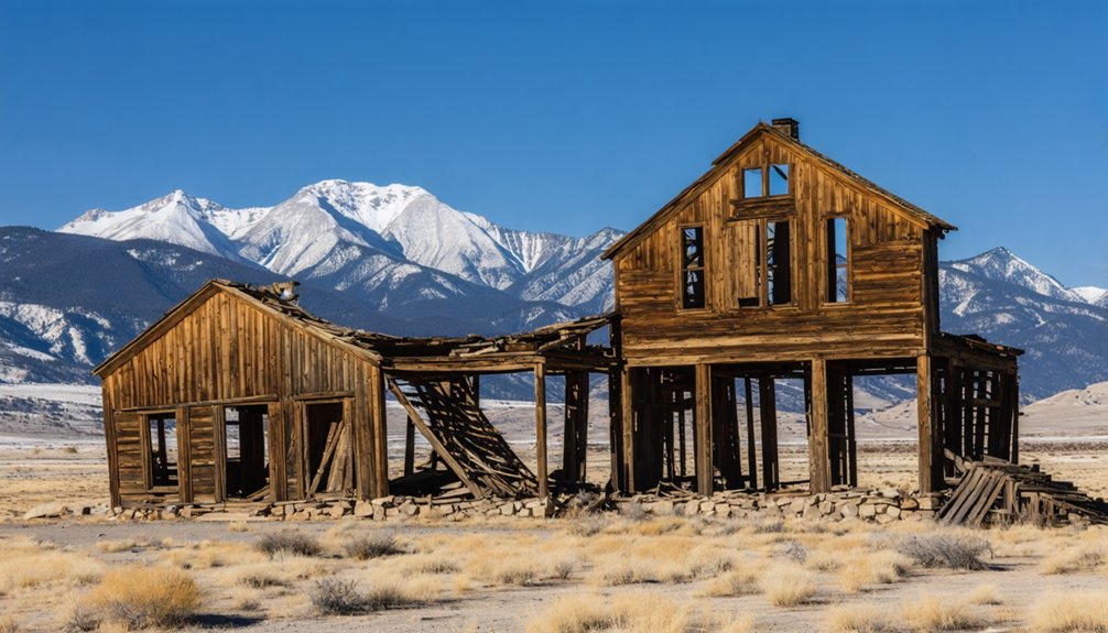
Population Decline and Abandonment
The railroad’s golden era couldn’t last forever. When diesel engines replaced steam in the early 1950s, Thompson Springs lost its purpose.
You’ll see population dynamics shift dramatically—Sego shuttered completely in 1955, its 500 residents vanishing after the mine sold for a mere $25,000. Thompson hung on, but Interstate 70’s construction dealt another blow, routing travelers away from Main Street.
Today, you’ll witness urban decay firsthand: the Thompson Motel’s graffiti-scarred walls, tumbleweeds piling against secured doors, collapsed ceilings exposing wooden beams to desert air.
Discarded belongings litter building interiors—remnants of lives once lived here. Amtrak further diminished the town’s viability when it moved the passenger platform to Green River in 1994. Yet Thompson refuses to die completely, clinging to existence as an I-70 rest stop, one of only two survivors from Grand County’s 1890s villages. Thompson and Cisco stand as the only remaining communities from an era when the area supported dozens of settlements.
Present-Day Remnants and Access
Despite its weathered appearance, Thompson Springs persists as a living relic along I-70’s barren stretch through central Grand County. You’ll find collapsing structures and abandoned storefronts that tell stories of better days.
The town’s historical significance becomes evident as you explore remnants of old motels and cafés, though few residents remain in this near-ghost town.
To reach this windswept outpost, you’ll navigate straightforward desert routes:
- Exit I-70 at Thompson (#187) and head north on UT-94
- Drive 4.6 miles through deteriorating Thompson Springs proper
- Cross railroad tracks where morning trains still blast whistles at 8 a.m.
- Continue on passable dirt roads (high-clearance recommended after rain)
The journey rewards those seeking authentic Western decay, where freedom means wandering among structures slowly surrendering to time’s relentless advance.
Castleton: The Town That Almost Became County Seat
Nestled at the southeastern end of Castle Valley, twenty-eight miles northeast of Moab, Castleton emerged from the red dust in the 1860s when placer gold miners, cowboys, and sheepherders first wandered through.
The town’s pulse quickened in 1888 when prospectors struck gold in the quartz veins of Miner’s Basin high in the La Sal Mountains.
Castleton history tells of a settlement that dared to challenge Moab itself. During its heyday, you’d find everything a frontier town needed: general stores, hotels, saloons, a blacksmith shop, even a Sunday school.
The county seat competition wasn’t just local pride—it represented real power and prosperity. Charles Edward Miller’s general store anchored the community, doubling as the post office.
But the 1907 financial panic devastated the hardrock mines, and Castleton’s dream died with them.
Valley City: Highway Settlement North of Moab
Just a few miles north of Moab, where the highway cuts through red sandstone country, Valley City sprang up in 1905 with promises that would’ve made any homesteader’s heart race.
The Grand Valley Land and Mineral Company dangled visions of irrigated fields and 2,500 fruit trees before enthusiastic settlers seeking their own slice of southeastern Utah.
Howard Balsley rode the rails from Indianapolis in 1908, cash in hand, ready to build something lasting.
But the farming community’s foundation cracked when a bank officer gambled away the irrigation funds on racehorses instead of completing the dam.
What Valley City promised settlers:
- 40 acres of cultivated farmland
- Completed irrigation dam
- Established two-story homes
- Thriving orchard community
The lawsuit failed. The investment vanished. Balsley relocated to Moab, where he’d later strike it rich in uranium.
Mesa and Pinhook: La Sal Mountain Communities
You’ll find Mesa and Pinhook clinging to the western slopes of the La Sal Mountains, where Mormon pioneers hammered gun holes into their cabin walls and prayed the refuge would hold.
These weren’t mining camps—cattle kept these communities alive until the economy crashed and families packed their wagons westward.
The tent villages that once dotted these high meadows have vanished now, leaving only the wind-scrubbed foundations where ranchers once watched their herds graze against snow-peaked mountains.
Historical Mining Settlement Development
When prospectors from Colorado’s San Juan Mountains fanned across the La Sal Mountains in 1888, they sparked a mining rush that would birth several rough-hewn communities on these forested slopes east of Moab.
You’ll find remnants of their ambitions scattered throughout peaks like Mt. Waas and Green Mountain, where basic mining techniques extracted modest fortunes from stubborn rock.
The gold rush spawned distinct settlements:
- Miners Basin – A ravine town housing 67 souls by 1899, now accessible via challenging 4WD trails
- Mesa – A village on Wilson Mesa supporting farmers and ranchers alongside prospectors
- Pinhook – A tent community marking frontier conflict, including an 1881 battle commemorated by historical markers
- Eagle City – Yielding $15,000 in gold between 1891-1893
Tent Village Characteristics
Canvas snapped in the mountain winds as Pinhook’s residents crawled from their tents each morning, fingers stiff from the cold that seeped through fabric walls throughout the night.
This tent architecture defined life in the La Sal Mountains—you’d assemble shelter quickly, chase rumors of ore strikes quicker, and abandon camp without looking back. These transient communities thrived on mobility rather than roots.
You’ll find no foundations marking where Mesa and Pinhook once stood, just clearings where miners huddled around communal fires between shifts underground.
When violence erupted on June 15, 1881, those canvas walls offered zero protection during the bloody confrontation. Survivors learned what every tent-dweller knew: freedom meant vulnerability, and mountain living demanded accepting both.
La Sal Mountain Location
The La Sal Mountains rise 8,000 feet above the desert floor, their snowcapped peaks visible from seventy miles away across Utah’s red rock country.
You’ll find Pinhook nestled within this dramatic landscape, where mountain ecology shifts from sagebrush flats to alpine meadows in just a few miles.
Native Americans called these peaks “Five Mountains,” using them as seasonal hunting grounds while settlers later claimed the lower elevations for farming and ranching.
Resources that drew settlers to the La Sal region:
- Fresh water flowing from mountain snowmelt
- Timber for construction and fuel
- Wild game inhabiting various elevations
- Irrigable lands on valley floors
The southern Colorado-Utah mail route passed through here, connecting isolated communities to distant markets.
You’re standing where survival meant understanding vertical geography.
Exploring the Abandoned Structures of Sego Canyon
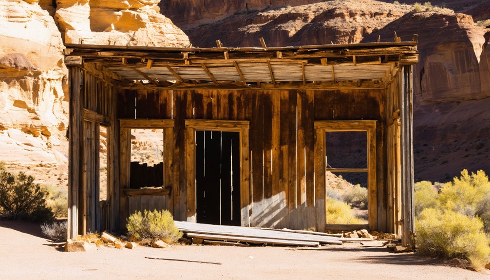
Nestled against rust-colored cliffs just off Interstate 70, Sego Canyon’s ghost town reveals itself gradually—first the weathered stone shell of the company store, then scattered foundations poking through desert scrub, and finally the crumbling two-story boarding house that once housed workers from six continents.
You’ll need high clearance to navigate the rough access road, but the reward transcends typical ghost town exploration. Beyond the ruins, ancient Barrier Canyon rock art adorns canyon walls—mysterious red figures without limbs watching over what remains of Henry Ballard’s coal operation.
Treasure hunters burned most structures in 1973, leaving only stone skeletons and scattered debris. Railroad trestles still span dry washes, and an overgrown cemetery holds both marked and forgotten graves from Sego Canyon’s brief industrial pulse.
Planning Your Ghost Town Adventure Near Arches
Ancient pictographs fade into memory as you shift focus toward logistics—because stumbling upon these forgotten settlements requires more than spontaneity and a full tank of gas.
Desert exploration demands preparation. You’ll need water—more than seems reasonable—sunscreen, and respect for private property boundaries marking many ghost towns.
Essential considerations for your journey:
- Route clustering: Valley City sits 15 minutes from Arches; Cisco requires 50 miles round-trip from Moab
- Timing: Visit during daylight hours; desert conditions turn hostile after dark
- Property rights: Most sites remain privately owned—observe from roadsides, don’t trespass
- Facility reality: Zero amenities exist at these locations; pack everything you’ll need
Home of Truth pairs naturally with Needles District drives. Castleton enhances Highway 128’s scenic route. Each ghost town offers distinct character without tourist infrastructure constraining your freedom.
Frequently Asked Questions
Are Any Ghost Towns Near Arches National Park Still Inhabited Today?
No, you won’t find current residents in these inhabited ghost towns near Arches. Cisco, Thompson, Sego, and Home of Truth stand empty—silent remnants where wind whispers through abandoned buildings and memories fade.
Beyond the desolation of these forgotten places, the ghost towns surrounding Area 51 add an air of mystery to the landscape. Legends of extraterrestrial encounters and secret government experiments loom large in the imaginations of those who dare to venture nearby. Each abandoned structure tells a story, as curious explorers search for clues hidden in the dust and decay.
What Caused Most Ghost Towns Near Moab to Be Abandoned?
Like ghost miners chasing fool’s gold, you’ll find mining decline stripped Moab’s towns bare. Economic factors—depleted ore veins, collapsed operations, transportation shifts—transformed bustling camps into silent ruins where prosperity’s echo faded into windswept dust.
Can You Visit Ghost Town Sites Year-Round or Only Seasonally?
You’ll find most ghost towns near Arches accessible year-round, though seasonal accessibility varies by location. While Sego and Cisco welcome exploration anytime, you’ll want weather considerations for winter roads and summer heat affecting your journey.
Do I Need Special Permits to Access Ghost Towns on Private Property?
Dusty roads fade into barbed wire reality—you’ll need permission from landowners before exploring. Land ownership trumps wanderlust here. Access rights aren’t guaranteed; contact property owners directly, respecting boundaries that protect both history and ranchers’ livelihoods.
Are There Guided Tours Available for Ghost Towns Near Arches?
No guided ghost tours exist for these sites—you’ll explore independently, discovering their historical significance on your own terms. The freedom to wander abandoned buildings and mining ruins creates deeply personal, unscripted adventures beyond organized tourism.
References
- https://www.utahsadventurefamily.com/5-ghost-towns-in-utah-for-families/
- https://www.visitutah.com/things-to-do/history-culture/ghost-towns
- https://welovetoexplore.com/tag/ghost-towns/
- https://www.youtube.com/watch?v=0tTpY_Wn-eA
- https://www.grandcountyutah.net/388/Ghost-Towns-Communities
- https://www.tripadvisor.com/ShowTopic-g143011-i6453-k3029697-Ghost_Towns-Arches_National_Park_Utah.html
- https://www.scoutingny.com/crossing-utah-ghost-towns-dinosaurs-arches-and-a-home-in-a-rock/
- https://wereintherockies.com/sego-canyon/
- https://www.legendsofamerica.com/ut-segocanyon/
- https://www.moabhappenings.com/Archives/pioneer0411.htm


