You’ll find some of Arizona’s most fascinating ghost towns within an hour’s drive of Bisbee, where abandoned mining camps and deserted settlements reveal the boom-and-bust cycles that shaped Cochise County‘s rugged landscape. The 18-mile Cochise County Ghost Town Trail connects Pearce, Courtland, and Gleeson, while Charleston and Millville’s ruins mark the lawless San Pedro River mill towns that processed Tombstone’s silver. Ruby stands as the Southwest’s most intact mining camp with over two dozen preserved buildings from its lead and zinc operations. Each site offers unique glimpses into the frontier communities that thrived here between the 1870s and 1940s.
Key Takeaways
- Lowell, Bisbee’s copper mining neighbor, declined after the Lavender Pit ceased operations in 1974.
- Pearce, Courtland, and Gleeson form an 18-mile ghost town circuit featuring old jails, ruins, and historical museums.
- Charleston and Millville, located nine miles from Tombstone, were lawless mill towns abandoned after 1886 flooding.
- Tombstone, though still inhabited, preserves its 1880s silver mining boomtown heritage and Wild West history.
- Ruby, Arizona’s most intact ghost town, contains over two dozen buildings from its lead and zinc mining era.
Tombstone: The Town Too Tough to Die
While scouting for Apache warriors in the harsh hills of Southeastern Arizona Territory, Ed Schieffelin stumbled upon something far more valuable than military intelligence. His 1877 silver discovery launched Tombstone history as one of the West’s most legendary boomtowns.
Within fifteen months, Schieffelin and his partners extracted $500,000 in silver from claims like the Lucky Cuss and Tough Nut. The town’s silver mining operations grew so extensive that pumps removed 2,500,000 gallons of water daily from flooded shafts.
You’ll find a settlement that refused to surrender, even after devastating fires in 1881 and 1882 reduced downtown to ashes. Tombstone rebuilt within six months each time, earning its defiant nickname: “The Town Too Tough to Die.” The Chiricahua lands that Schieffelin traversed stretched from Sonora, Mexico to New Mexico and Arizona, territories once controlled by the Spaniards since 1804.
By the mid-1880s, the population had surged to approximately 15,000-20,000 residents, transforming the once-desolate landscape into a thriving frontier metropolis.
Lowell: Bisbee’s Copper Mining Neighbor
Just seven miles northwest of Tombstone’s silver bonanza, copper would write its own chapter in Arizona’s mining saga.
Lowell’s history began in 1879 when W.S. Salmon located claims that Frank Hanchett would transform into the Lowell & Arizona Copper Mining and Smelting Company by 1899.
You’ll find this mining legacy intertwined with Bisbee’s fortunes—the Copper Queen Consolidated Mining Company discovered crucial orebodies here by 1902, establishing a tent community that’d grow into a proper town with Erie Street’s saloons and boarding houses.
The town’s peak growth occurred during the 1920s-1940s when Erie Street bustled with commercial activity.
The Lavender Pit’s 1950 opening produced 86 million tons of ore before economics shuttered operations in 1974.
The Warren-Bisbee Railway began service in 1908, connecting Lowell’s depot to the surrounding mining district with 30-minute electric railway runs.
Today, you can explore preserved fragments like Erie Street’s restored 1950s storefronts and the visible Junction Shaft headframe.
Charleston and Millville: Lawless Mill Towns of the San Pedro River
When Tombstone’s silver mines struck it rich in the late 1870s, they faced a critical problem: no water for ore processing.
You’ll find the solution nine miles southwest along the San Pedro River, where Charleston and Millville emerged as twin mill towns processing Tombstone’s ore. Over 1,000 residents settled here by the early 1880s, creating a hub of mining history that flourished for eight violent years.
The towns earned their lawlessness legacy through gunmen, bandits, and failed heists—including an 1882 Tombstone Mining Company robbery that killed engineer M.R. Peel. Charleston’s post office opened on April 17, 1879, serving the growing mill town community.
Their boom ended when Tombstone’s mines flooded in 1886, followed by the devastating 1887 earthquake and floods. Charleston’s economy based on milling silver ore collapsed as the mines ceased production.
Today you’ll discover Millville’s marked trail and Charleston’s brush-hidden ruins, silent witnesses to Arizona Territory’s untamed frontier.
The Cochise County Ghost Town Trail: Pearce, Courtland, and Gleeson
Three interconnected ghost towns form Cochise County‘s most accessible mining heritage circuit, where you’ll discover distinct chapters of Arizona’s boom-and-bust frontier.
Exploring beyond Cochise County, you can also find intriguing ghost towns near Peoria Arizona that reveal stories of past communities. These sites offer a glimpse into the harsh realities faced by early settlers and the fleeting nature of prosperity in the region. Each ghost town presents unique remnants and artifacts that reflect a vibrant, yet tumultuous history.
Pearce History begins with James Pearce’s 1894 Commonwealth Mine discovery, leaving behind an old jail along its picturesque main street. You’ll find it 85 miles from Tucson. The old jail was constructed with poured concrete, making it a lasting relic.
Eighteen miles south via smooth graded dirt road, Courtland Survival extended until 1942 when its post office finally closed—despite its 2,000-person peak, it’s now the trail’s most barren site. The desert has scattered foundations and ruins across the landscape where businesses once thrived.
Gleeson Legacy runs deepest, from Chiricahua Apache turquoise mining through John Gleeson’s copper boom. The standing Bono Store displays an 1982 mural, while the museum offers walking tour maps.
These Ghost Towns span an 18-mile circuit requiring just thirty minutes of driving time.
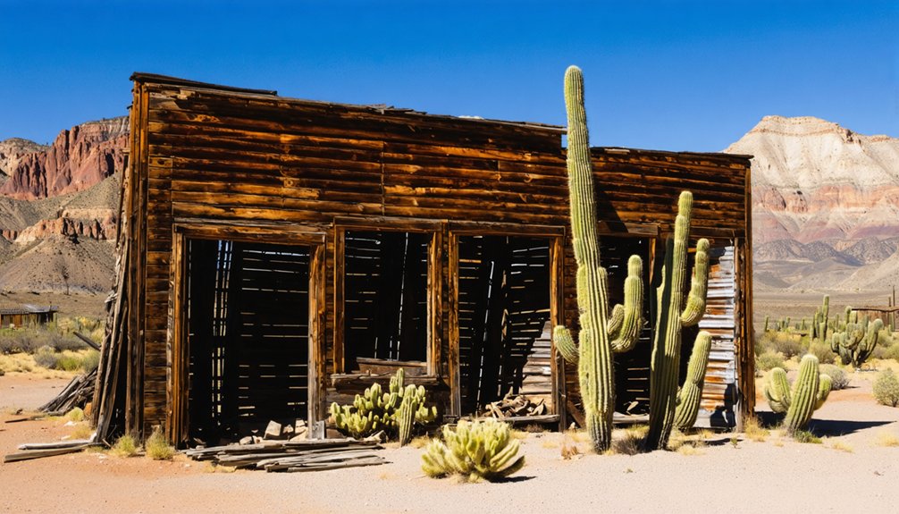
Ruby: The Southwest’s Largest Preserved Mining Camp
While the Cochise County circuit offers readily accessible ruins, Ruby stands as Arizona’s most intact mining town—a remarkably preserved symbol of early 20th-century industrial ambition hidden in the rugged borderlands south of Arivaca.
Ruby history traces back to the 1877 Montana mine, which evolved from surface gold operations into Arizona’s leading lead and zinc producer by 1940. The mining infrastructure tells a compelling story:
- Water Engineering Marvel: A 16-mile pipeline completed in 1930 lifted water 1,500 feet through storage tanks to sustain 24-hour operations.
- Preserved Structures: Over two dozen buildings remain standing, including the 1916 schoolhouse with original chalkboards and the sturdy adobe jail.
- Living Ecology: The abandoned mine shaft now shelters approximately 190,000 Mexican free-tailed bats.
The town reached its zenith in 1912 when it achieved official status with a population nearly 1,200 residents. Between 1934 and 1937, the Montana Mine ranked as the leading producer of lead and zinc while simultaneously becoming the state’s third-largest silver producer.
This National Register site closed to visitors in June 2024.
Frequently Asked Questions
What Is the Best Time of Year to Visit Ghost Towns Near Bisbee?
You’ll find spring and fall offer ideal seasonal weather for exploring ghost towns, with comfortable temperatures between 45°F-85°F and minimal crowds. These periods let you appreciate the sites’ historical significance while avoiding summer’s heat and monsoons.
Are the Ghost Towns Near Bisbee Safe to Explore With Children?
You’ll discover absolute treasure troves of history! These ghost towns are family-friendly activities when you take basic safety precautions—watch for uneven ground, supervise kids near old structures, bring water, and stick to marked trails while exploring together.
Do I Need a Four-Wheel Drive Vehicle to Access These Ghost Towns?
You’ll need high-clearance for Ruby’s remote terrain, but Courtland, Pearce, and Lowell accept standard vehicles. Vehicle recommendations emphasize ground clearance over four-wheel drive. Pack off road essentials like spare tires for unpaved Ghost Town Trail sections.
Are There Guided Tours Available for the Ghost Towns Near Bisbee?
Yes, you’ll find guided tour options through local tour companies like Lavender Jeep Ghost Town Tours, which’ll take you through Gleeson, Courtland, and Pearce along the Real Ghost Town Trail near Bisbee.
Can I Camp Overnight at Any of the Ghost Town Sites?
You’ll find overnight camping at Kentucky Camp’s ghost town amenities, where history meets adventure. Understanding camping regulations proves essential—dispersed camping surrounds Bisbee’s abandoned sites, though you must verify public lands and avoid designated restricted zones before settling in.
References
- https://www.youtube.com/watch?v=z1iGbFJH0L8
- https://middlejourney.com/visiting-tombstone-and-bisbee-arizona/
- https://klaq.com/lowell-arizona-aricana-project/
- https://www.arizonahighways.com/article/arizona-ghost-towns
- https://www.visitarizona.com/like-a-local/4-arizona-ghost-towns-you-may-have-never-heard-of
- https://www.visittucson.org/blog/post/8-ghost-towns-of-southern-arizona/
- https://southernarizonaguide.com/ghost-towns-southern-arizona/
- https://www.explorecochise.com/ghost-towns/
- https://tombstonegunfights.com/history/
- https://tombstonechamber.com/about-tombstone-az/tombstone-history/


