
You’ll find six authentic ghost towns within reach of Black Canyon of the Gunnison National Park, each preserving Colorado’s 1880s mining heritage. Saint Elmo showcases 150 patented claims and buildings listed on the National Register since 1979, while Crystal’s 1893 Mill remains the state’s most photographed structure. Gothic now serves as the Rocky Mountain Biological Laboratory, and Hancock’s railroad ruins sit at 11,000 feet elevation. Whitepine and Doyleville bear witness to the devastating 1893 Silver Panic that transformed thriving communities into abandoned settlements, their accessible structures revealing the complete story of boom-and-bust frontier economics.
Key Takeaways
- Whitepine, established in 1880, is accessible via Gunnison County Road 888 with surviving buildings from its silver mining era.
- Crystal Mill, built in 1893 near Marble, is Colorado’s most photographed structure and reachable by 4WD or guided tour.
- Doyleville emerged in 1879 along Saguache Creek with abandoned mining structures accessible via County Road 58FF.
- Gothic at 9,514 feet features restored 1880s buildings now housing the Rocky Mountain Biological Laboratory with daily summer tours.
- Saint Elmo, founded in 1875, is Colorado’s best-preserved mining town with over 150 patented claims and National Register status.
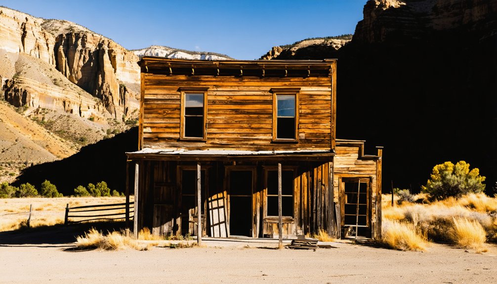
Saint Elmo: Colorado’s Best-Preserved Mining Town
Saint Elmo’s story began in 1875 when prospectors Abner Wright and John Royal discovered a silver deposit in Chalk Creek Canyon at what became the Mary Murphy Mine.
Originally called Forest City, the settlement officially launched in 1880 during the mining boom, quickly reaching 2,000 residents by 1881. The Denver, South Park and Pacific Railroad arrived that same year, establishing a crucial supply line through Alpine Tunnel.
Within a single year, Forest City transformed into a thriving settlement of 2,000 souls, connected by rails through the Alpine Tunnel.
You’ll find this ghost town exemplifies Colorado’s mining legacy through over 150 patented claims.
The Mary Murphy Mine alone produced 220,000 ounces of gold worth $4.4 million before closing in 1925.
Though fire ravaged the business district in 1890 and the railroad ceased operations in 1922, Saint Elmo endured. The Alpine Tunnel closed in 1910, but new ore discoveries briefly revived mining activity in the following years.
Listed on the National Register in 1979, its preserved buildings offer you tangible connections to frontier independence. The town’s infrastructure included smelting works, several stores, hotels, and a telegraph office that served the bustling mining community.
Crystal: Home of the Iconic 1893 Crystal Mill
You’ll find Crystal 6 miles east of Marble, accessible only by 4WD road through rugged terrain that once isolated this silver mining camp.
The town’s centerpiece, the 1893 Crystal Mill powerhouse, stands as Colorado’s most photographed structure—though it never actually milled lumber but instead operated as a compressor station for the Sheep Mountain Tunnel mines.
Built by George C. Eaton and B.S. Phillips, this wooden structure clings to an outcrop above the Crystal River, where it powered air drills and ventilation systems using a horizontal waterwheel until operations ceased in 1917.
The mill’s wooden dam repeatedly washed out during high water runoff, eventually requiring engineers to construct a wooden flume to divert water from upstream.
The historic powerhouse earned its place on the National Register of Historic Places in 1985, recognizing its significance to Colorado’s mining heritage.
Historic Mining Town Origins
- Official incorporation on June 8, 1881—just one year after settlement.
- Population surge to 500 residents seeking fortune.
- Seven working silver mines by 1886.
This mining heritage established Crystal as the first permanent settlement in upper Crystal Valley, drawing ambitious fortune-seekers who built a thriving community in Colorado’s rugged high country, complete with newspapers, hotels, and the exclusive Crystal Club. The town’s prosperity was further enhanced by the Crystal Mill, built in 1893 to serve as a power plant for local mines. Miners employed early techniques using star drill bits and sledge hammers to extract precious ore from the mountain tunnels.
Crystal Mill Photography Landmark
Six miles east of Marble stands the 1893 Crystal Mill, a wooden powerhouse perched dramatically on a rocky outcrop above the Crystal River.
George C. Eaton and B.S. Phillips constructed this compressor station to harness river water through a penstock and horizontal waterwheel, driving an enormous air compressor that powered drills in Sheep Mountain and Bear Mountain mines.
Operations ceased in 1917, but preservation efforts by historical societies and local residents saved this NRHP-listed landmark.
You’ll find it’s become one of the most photographed structures in the American West.
Access requires navigating a rough, one-lane road that’s only passable during summer and fall months, though you can also reach the site by foot, mountain bike, or guided jeep tour.
The road continues past the mill to the nearly abandoned town of Crystal, which once housed around 500 residents during its mining boom decades.
Photography Tips: Frame your shots with surrounding aspens and mountains for iconic compositions. The mill’s dramatic positioning above rushing water creates compelling visual contrasts you won’t find elsewhere in Colorado’s ghost town country.
Remote 4×4 Access Route
- Fork right at Road 314 past Devil’s Punchbowl toward Crystal’s three-route junction.
- One-way sections demand constant awareness for oncoming traffic on blind corners.
- Recovery gear recommended for technical obstacles rated 3-4 difficulty.
Expect slow progress through rocky terrain, tight passages requiring pull-overs, and seasonal closure from Lizard Lake November through May. Road 314 is unsuitable for beginners due to its narrow and rugged conditions. The trail features dirt and sand with steep dips and climbs that can become slippery during or after rain.
Gothic: Where Wildlife and History Meet
At 9,514 feet in the West Elk Mountains, Gothic’s handful of restored 1880s structures provide exceptional photography opportunities against a backdrop of peaks reaching 12,631 feet.
You’ll find the original boomtown buildings now serve the Rocky Mountain Biological Laboratory, where summer tours reveal both mining-era artifacts and active field research stations.
The site’s high-elevation ecosystem attracts diverse wildlife year-round, from marmots studied by scientists to elk and deer that frequent the valley, making Gothic equally valuable for wildlife observation and historic documentation.
Historic Buildings and Photography
While Gothic’s population has dwindled from over 400 buildings at its 1881 peak to a handful of weathered structures, seven buildings retain official designation for their historical value: Gothic Town Hall, Swallow’s Nest, Ore House, Mammal Lab, Barclay Cabin, McCloud Cabin, and Richards Cabin.
The 2020 conservation easement with Colorado Open Lands guarantees historic preservation while maintaining access for architectural photography enthusiasts.
You’ll find exceptional photographic subjects including:
- Smith Opera House (1882) – Greek symmetry with Italianate brackets and Victorian floor plan in red brick
- Original Saloon – Laura Gilpin captured this isolated structure against towering peaks
- Rustic cabins – Scattered log buildings beneath Gothic Mountain’s 12,625-foot craggy face
Daily summer tours cover mining history and designated historic sites maintained by Gunnison County at this 9,514-foot elevation townsite.
Wildlife Viewing Opportunities
Beyond the weathered facades and rustic cabins, Gothic’s 9,514-foot elevation supports an exceptional concentration of wildlife that’s drawn researchers to the Rocky Mountain Biological Laboratory since 1928.
You’ll find the area’s wildlife diversity exceptional year-round, with broad-tailed hummingbirds dominating summer camps and red squirrels most active mornings between 8-11 AM. The lab’s BioBlitz project systematically documents all taxa near Gothic, offering you direct insights into species patterns.
For birdwatching tips, focus on riparian zones where neotropical migrants breed, and scan rocky outcrops where vigilant mammals monitor for predators. Bobcats and foxes hunt under darkness, controlling rodent populations throughout the basin.
The lab’s 150 summer biologists conduct ongoing studies you can observe firsthand, making Gothic a living laboratory where historical preservation meets active wildlife research.
Hancock: High-Altitude Railroad Ruins

Perched at 11,000 feet above sea level near Nathrop, Colorado, Hancock stands as one of the state’s highest-elevation railroad settlements, established in 1880 to support construction of the ambitious Alpine Tunnel.
The Hancock history reveals rapid growth—by 1881, the town boasted nearly 200 residents, a telegraph office, and saloons serving mine laborers.
Railroad remnants mark its legacy: a water tower installed in 1882, coal bins, and the rail bed now serving as a hiking trail.
To reach this windswept site, you’ll need:
- High-clearance vehicle for rocky CR 295
- Appropriate cold-weather clothing for extreme altitude
- Navigation from CR 162, 5.7 miles uphill from St. Elmo
After the Alpine Tunnel closed in 1910 and trains ceased in 1926, Hancock’s economy collapsed, leaving only crumbled cabins as evidence of frontier ambition.
Whitepine: A Town Shaped by the Silver Panic
Unlike Hancock’s railroad-driven economy, Whitepine’s fortunes rose and fell with silver prices.
You’ll find this ghost town established in 1880 when prospectors R.E. McBride and the Boon Brothers crossed the Continental Divide in 1878, discovering rich silver deposits along Tomichi Creek’s headwaters.
By 1883, over 1,000 miners worked the North Star, Eureka, and Carbonate King mines while Main Street stretched three-quarters of a mile through boulder-strewn terrain.
At its peak, Whitepine’s three major mines employed over 1,000 workers along a three-quarter-mile Main Street carved through rugged terrain.
The 1893 Silver Panic devastated this silver mining community, demonetizing silver and collapsing markets overnight.
Within a year, Whitepine stood deserted.
Though revival attempts occurred during both World Wars and Callahan Mining Company operated until 1953, heavy snowfall now prevents year-round habitation.
You can explore surviving buildings via Gunnison County Road 888.
Doyleville: Jesse James’ Historic Hideout
Sixty miles northeast of Black Canyon of the Gunnison, Doyleville emerged in 1879 as a supply hub for scattered mining operations along Saguache Creek’s tributaries.
Named after postmaster Michael Doyle, this settlement thrived during the silver boom before the 1893 crash devastated its economy.
Doyleville legends persist about Jesse James using remote canyons as hideouts during the 1870s, though no verified records support these claims.
Outlaw history here mirrors folklore common to Colorado’s isolated ghost towns:
- James Gang’s documented western travels after Missouri robberies fueled speculation
- Transient criminals evaded posses in Saguache County’s rugged terrain
- Remote locations attracted both legitimate miners and those avoiding law enforcement
Today, you’ll find abandoned mining structures and log cabin remnants accessible via County Road 58FF, though private property boundaries restrict exploration.
In addition to the remnants of the mining era, there are numerous abandoned settlements in Alaska that evoke a sense of history and solitude. Many of these ghost towns tell stories of the people who once called them home, with crumbling structures standing as a testament to their resilience. Exploring these sites can provide a deeper understanding of the challenges faced by early settlers in this harsh yet beautiful landscape.
Frequently Asked Questions
What Time of Year Is Best to Visit Ghost Towns Near the National Park?
Late September through early October offers the best seasons for exploration—you’ll find golden aspens framing abandoned structures, comfortable 50-70°F weather considerations, fewer crowds, and clear roads before snow closes high-elevation passes.
Are 4×4 Vehicles Required to Reach All These Ghost Towns?
No, you won’t need 4×4 accessibility for all ghost towns. Saint Elmo, Doyleville, Whitepine, and Crested Butte welcome regular cars. Vehicle recommendations include high-clearance 4x4s for Tin Cup, Vicksburg, Winfield, and Crystal City’s rugged terrain.
Can You Camp Overnight in These Ghost Town Areas?
You can’t camp overnight within these ghost towns due to camping regulations, but you’ll find dispersed camping opportunities in the surrounding Gunnison National Forest. Gothic requires overnight permits for laboratory housing only.
Are There Guided Tours Available for These Historic Mining Sites?
You’ll be absolutely shocked to discover guided tour availability is minimal for these sites. Historic site regulations vary by location, with some towns like Gothic restricting access while Crested Butte offers self-guided walking tours year-round.
What Safety Precautions Should Visitors Take When Exploring Ghost Town Structures?
You’ll protect your personal safety by staying outside unstable 1880s structures with collapsing wood frames. Don’t enter abandoned buildings, closed mine tunnels, or fenced areas—observe from roads where structural integrity issues won’t threaten you.
References
- https://www.explore.com/1883174/st-saint-elmo-colorado-best-preserved-ghost-town-america-between-black-canyon-gunnison-springs/
- https://gunnisoncrestedbutte.com/blog/haunted-places-in-crested-butte-and-gunnison/
- https://en.wikipedia.org/wiki/List_of_ghost_towns_in_Colorado
- https://www.uncovercolorado.com/ghost-towns/crystal/
- https://gunnisoncrestedbutte.com/blog/town-profiles-whitepine/
- https://ohtheplacestheygo.wordpress.com/2019/09/28/a-ghost-town-an-old-mine-and-a-dams-gunnison-co/
- https://www.coloradolifemagazine.com/printpage/post/index/id/172
- https://welovetoexplore.com/the-tomboy-mine-ghost-town-in-colorado/
- https://www.tripadvisor.com/Attraction_Review-g60740-d259721-Reviews-Gothic-Gunnison_Colorado.html
- https://westernmininghistory.com/towns/colorado/st-elmo/


