You’ll find five remarkable ghost towns within an hour’s drive of Bridgeport, California. Bodie State Historic Park, the crown jewel, preserves 65 saloons and buildings in “arrested decay” from its 10,000-person peak in 1879. Masonic’s three terraced communities sit in the Sweetwater Basin, where ore once valued at $800 per ton fueled the 1902 boom. Bennettville at 9,300 feet and Chemung Mine offer high-altitude exploration, while Lundy’s scattered ruins tell stories of natural disasters. The sections ahead detail specific routes, seasonal access, and essential safety gear for exploring these historic sites.
Key Takeaways
- Bodie State Historic Park, the most famous ghost town, sits 23 miles from Bridgeport with 65 preserved buildings in “arrested decay.”
- Masonic Ghost Town features three terraced communities from the 1860s gold strike, founded by Freemasons near Bridgeport.
- Bennettville, at 9,300 feet elevation, is accessible via Tioga Road with two remaining weathered buildings from 1880.
- Chemung Mine, discovered in 1900 at 8,600 feet, produced over $1 million in gold before closing in 1938.
- Benton, 38 miles east of Bridgeport, was once Mono County’s largest population center with 1860s mining structures still standing.
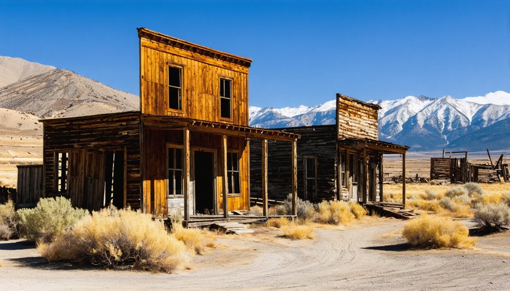
Bodie State Historic Park: California’s Best-Preserved Gold Rush Town
In the autumn of 1859, when Waterman S. Bodey discovered gold near Bodie Bluff, he couldn’t have imagined his namesake town would become California’s most authentic ghost town. Tragically, Bodey perished in a blizzard that winter, but his discovery sparked a mining district that exploded to 10,000 residents by 1879.
You’ll find Bodie history preserved exactly as miners left it in 1942—65 saloons, banks, and homes frozen in time. The State Park’s “arrested decay” approach to ghost town preservation means you’re seeing genuine artifacts, not reconstructions. Rangers and volunteers are available to answer your questions about the ghost town’s history.
Walk Main Street’s weathered buildings, peer through dusty windows at original furnishings, and experience the raw reality of gold rush life. It’s freedom from sanitized history—authentic, unvarnished, and utterly enchanting. Plan your visit between 9 am and 6 pm from March through October, or 9 am to 4 pm during winter months.
Masonic Ghost Town: Terraced Mining Settlement in the Sweetwater Basin
Three terraced communities cascade down Masonic’s canyon walls in the Sweetwater Basin, ten miles northeast of Bridgeport—a unique architectural arrangement born from the terrain’s stubborn refusal to offer flat ground.
Upper Town (originally Lorena), Middle Town, and Lower Town (Caliveda) functioned as distinct settlements connected by the district’s Masonic legacy, founded by Freemasons who struck gold in the 1860s.
The July 4, 1902 strike at Pittsburg-Liberty Mine transformed everything. Ore assayed at $35-$800 per ton, with one 1904 nugget hitting $4,000.
Mining techniques advanced rapidly—by 1907, a 10-stamp mill processed ore while aerial tramways transported material between elevations. Forty claims sprawled across seventy square miles.
Middle Town emerged as the commercial center, hosting the post office, hotel, and various establishments that served the growing population of nearly 1,000 residents by 1906.
Masonic maintained a remarkably peaceful environment compared to other mining camps, with Dr. E.T. Krebs noting no reported shootings during his tenure providing medical care to the community.
You’ll find preserved three-tier structures, cabin ruins, and intact tramway systems—testaments to forgotten mining techniques and a town that peaked at 1,000 residents before fading by the 1930s.
Bennettville: The Failed Mining Dream at Tioga Pass
While Masonic’s terraced settlements clung to canyon walls at a modest 7,000 feet, Bennettville’s promoters positioned their enterprise at a punishing 9,300 feet—perched at the base of Tioga Hill where winter snows buried operations for eight months yearly.
Bennettville history began in 1880 when gold fever transformed William Bruskey’s 1874 Sheepherder Mine into Thomas Bennett’s ambitious headquarters. By 1882, you’ll find records showing 350 claims staked and a post office established.
Well-funded investors bored 1,000 feet of tunnel through solid rock, yet extracted virtually nothing.
The town’s early development included a sawmill that provided timber and building materials, alongside a boarding house, company office, and stable that briefly housed families seeking permanent settlement. Today, Bennettville’s mining legacy survives in two weathered buildings—a stable and probable assay office—plus foundations outlined in charred wood. The rusty machinery and stone walls stand as monuments to misplaced confidence, accessible via the Tioga Road their desperation built. The site remains a living graveyard of the unrealized hopes that once drove prospectors to these unforgiving heights.
Chemung Mine: Panoramic Views and Mining Relics
Perched at 8,600 feet above Bridgeport Valley, Chemung Mine commands a panoramic sweep that makes the arduous 5.2-mile journey up Masonic Road worthwhile—assuming your vehicle survives the deteriorating track.
Stephen Kavanaugh discovered the gold vein here in 1900, launching operations that yielded over $1 million despite chronic mismanagement and legal battles. The weathered mill structure still stands, evidence to sophisticated cyanide extraction and flotation methods once employed on-site. The ore was shipped to Bodie for smelting after being processed at Chemung. Founded in 1909, the mine produced gold and silver ore until operations ceased in 1938.
Over $1 million in gold extracted through cyanide processing, though mismanagement and courtroom drama plagued Kavanaugh’s 1900 discovery from the start.
What you’ll encounter at Chemung:
- Corrugated ruins clinging to windswept ridges overlooking Nevada’s border country
- Dangerous shafts where Chemung legends claim a mill owner met his end
- Prime panoramic photography from an 8,140-foot vantage point
- Free-range cattle wandering through history’s debris
Pack everything out. This freedom comes with responsibility.
Lundy: Semi-Ghost Town Along Lundy Lake Road
But Mining Legacy here tells a harsher truth.
Avalanches crushed cabins and mines throughout the 1880s. The Gorilla Mine, built beneath protective cliffs, survived until an 1882 avalanche forced evacuation—though the mine produced $61,773 worth of ore across five years. The 1887 inferno consumed twenty-five buildings in hours, starting at May Lundy Hotel. Nobody rebuilt.
Today’s dam submerges original settlement land, leaving scattered ruins among alpine meadows—testament to fortune-seekers who gambled against mountains and lost.
Benton: Desert Highway Mining Remnants
You’ll find Benton approximately 38 miles east of Bridgeport along Highway 120, where weathered structures from the 1860s mining boom still stand against the desert landscape.
The town’s remnants include stone foundations and corrugated metal buildings that once served the bustling supply center for Blind Spring Hill’s mining operations, when Benton claimed the largest population in Mono County by 1865.
Today’s approach along the desert highway reveals scattered evidence of this mining past, from the relocated Blind Spring Hill cabin to the cemetery marking where Robert Morrison and other early settlers met their ends.
Desert Highway Access Route
Although modern Highway 6 now provides a paved corridor through Nevada’s mineral belt, the original Desert Highway route to Benton carved through considerably more treacherous terrain.
Your desert navigation skills become essential when exploring these historical paths, where junction points still split toward abandoned mill foundations and ore dumps. The mining history here reveals itself through scattered infrastructure remnants that mark the 1860s gold rush era.
Key route characteristics include:
- Multiple split roads branching toward remote districts like Masonic and Tonopah
- Tram system foundations connecting mines to processing facilities
- Waste-rock dumps indicating historical transportation endpoints
- Deep downshafts positioned dangerously close to deteriorating road edges
You’ll find satellite imagery invaluable for identifying authentic routes versus dead-end exploration paths through this expansive basin landscape.
Historic Mining Era Structures
The scattered foundations and mill remnants along these Desert Highway routes tell the story of Blind Spring Hill’s explosive growth during the Civil War era, when ore assays revealed silver, copper, and iron deposits worth $1,500 per ton.
You’ll find evidence of primitive mining techniques throughout the district—miners hauled ore in 5-gallon kerosene cans to waiting wagons, a proof of their resourcefulness in this waterless terrain.
The Diana mine’s 4-stamp mill and reduction furnace still mark the landscape, while ore transportation evolved from leather bags carried to Partzwick’s 10-stamp mill, eventually reaching Bridgeport and Sacramento via freight lines bound for Welsh smelters.
When the Carson and Colorado Railroad arrived in 1883, it revolutionized operations, spawning the Comanche Mining and Reduction Company‘s 100-ton mill near Ross tunnel.
Planning Your Ghost Town Road Trip Route

When mapping your journey to Bodie and California’s mining heritage sites, start with the 9-stop route stretching from Shasta State Historic Park in the north to Calico Ghost Town near Barstow—a thorough itinerary that positions Bodie as the crown jewel immediately after Bridgeport.
For maximum flexibility exploring ghost town history, prepare strategically:
- Fuel up in Bridgeport before heading east on Highway 270; you’ll find zero commercial services at Bodie’s 8,379-foot elevation.
- Check road conditions via Caltrans (800-845-7922) since snow closures happen unpredictably.
- Pack emergency supplies: spare tire, water, snacks—remote dirt roads demand high-clearance vehicles.
- Extend your loop through Mono Lake and June Lake for a full-day immersion in authentic mining heritage.
Consider car or RV rentals for this dusty, liberating adventure through California’s untamed past.
Best Times to Visit Bridgeport’s Historic Mining Sites
Once you’ve mapped your ghost town route, timing becomes your most important decision—and having visited Bodie during both a July scorcher and a November snowstorm, I’ll save you from my mistakes.
Seasonal accessibility dramatically affects your experience. Bodie operates 9 am to 6 pm summers (May 15-October 31), shrinking to 4 pm closings October through Memorial Day with potential snow closures.
Winter visits mean reduced daylight and treacherous roads requiring chains. Weather considerations extend beyond Bodie—Black Diamond Mines’ hours expand from 8 am-5 pm in January to 8 am-8 pm by April, while tours run year-round weekends.
Peak season (Memorial Day-Labor Day) offers full facility access and extended exploration time. Spring and fall provide moderate temperatures without summer crowds, ideal for photographers seeking dramatic lighting.
What to Bring for Safe Ghost Town Exploration

After watching a fellow explorer step through rotted floorboards at Masonic—missing a rusty nail cluster by inches—I completely reorganized my ghost town kit, and you’d be wise to learn from near-misses rather than actual disasters.
Essential gear starts with sturdy boots and cut-resistant gloves. I’ve pulled broken glass from clothing too many times to skip long sleeves. For respiratory protection, invest in N95 respirators minimum—those old mining structures harbor asbestos and toxic dust that ordinary masks won’t stop.
Critical safety tips include carrying:
- Primary flashlight plus backup headlamp for hands-free navigation
- Offline maps and marking chalk for remote locations
- Thorough first aid kit with splinting materials
- Emergency blanket and water purification tablets
Your independence depends on self-sufficiency when cell service fails.
Photography Tips for Capturing Abandoned Mining Structures
Why do most ghost town photographs feel lifeless despite capturing actual decay? You’re missing the interplay between abandoned textures and lighting contrasts that define these spaces.
Position yourself low, shooting upward at 24mm to amplify emptiness within Bridgeport’s mining structures. Circle each building methodically—doorways become natural frames, rusting beams guide eyes downward into compositions.
Low angles at 24mm magnify desolation—circle structures systematically, transforming doorways into frames and rusted beams into compositional guides.
Your tripod isn’t optional here; it’s essential for 30-second exposures at f/8 that balance harsh window light against interior darkness.
I’ve found discarded objects—a single chair, weathered ledgers—anchor chaotic scenes powerfully. Use boulders as corner elements directing focus toward skeletal frameworks.
At night, long exposures under open sky transform ordinary documentation into something unsettling. Black and white processing heightens historical resonance, while artificial light reveals details daylight conceals.
Frequently Asked Questions
Are Dogs Allowed at the Ghost Towns Near Bridgeport?
You’ll find that most ghost towns near Bridgeport welcome dogs, though Bodie State Historic Park requires leashes. Curiously, 78% of California’s historic sites now accommodate pets. Always verify current dog friendly policies and ghost town regulations before visiting.
If you’re planning to explore ghost towns in California, don’t forget to take along some water for your furry friend. Many of these towns offer stunning views and historic structures that tell intriguing stories of the past. Make sure to bring your camera, as you’ll want to capture the unique charm and beauty of these forgotten places.
Exploring the history of Westville, California can provide insights into the area’s rich past and its transformation over the years. Abandoned structures and remnants of former residents reveal stories that pique the curiosity of both history buffs and casual visitors alike. As you wander through these historic sites, take a moment to connect with the past and imagine what life was once like in this intriguing town.
Which Ghost Towns Require Entrance Fees or Permits?
You’ll only need to pay entrance fees at Bodie State Historic Park, which requires admission as California’s official state park. Masonic, Ward, Chemung, and other area ghost towns have no permit requirements—you’re free to explore them.
Can You Camp Overnight Near These Ghost Town Sites?
You can’t camp inside Bodie or at the ghost towns themselves, but here’s the freedom: dispersed camping’s allowed on surrounding BLM and national forest lands near each site, following standard camping regulations for overnight stays.
Are Any Ghost Towns Wheelchair Accessible?
Bodie offers partial wheelchair access with paved paths and specialized equipment loans, though historic preservation limits modifications. You’ll find rough terrain challenging, but staff can arrange accommodations. Other nearby ghost towns lack accessibility features entirely.
How Far Is Bridgeport From Major California Cities?
Though Bridgeport’s remoteness might seem limiting, you’ll find it’s actually 120 miles from Reno, 50 miles from Mammoth Lakes, and 81 miles from Carson City—California landmarks easily reached via US 395’s scenic Bridgeport distance routes.
References
- https://patch.com/california/banning-beaumont/13-ghost-towns-explore-california
- https://www.atlasobscura.com/things-to-do/california/ghost-towns
- https://www.visitcalifornia.com/road-trips/ghost-towns/
- https://sierrarecmagazine.com/discover-masonic-ghost-town-and-so-much-more-4×4-near-bridgeport/
- https://nvtami.com/2026/01/04/bennettville-ghost-town/
- https://en.wikipedia.org/wiki/Bodie
- https://lifeinmyyears.com/2023/03/05/the-u-s-395-chronicles-bridgeport-and-the-ghost-town/
- https://www.mountwhitneyforum.com/ubbthreads.php?ubb=showflat&Number=58239
- https://www.parks.ca.gov/bodie
- https://californiathroughmylens.com/bodie-ghost-town/


