You’ll find several ghost towns within easy driving distance of Bryce Canyon National Park, including Widtsoe (abandoned in 1936 due to severe drought), Osiris (featuring a stone-and-concrete mill from 1910), and Grafton near Zion (finally abandoned in 1944 after decades of flooding). These settlements preserve Mormon pioneer heritage from the 1860s through 1980s, with accessible structures, cemeteries, and historical remnants. Spring and fall offer the most comfortable conditions for exploration, though you’ll need proper vehicle preparation for remote dirt roads and essential supplies for safe backcountry visits.
Key Takeaways
- Widtsoe Ghost Town, established 1908 in Johns Valley northeast of Bryce Canyon, was abandoned by 1936 due to severe drought.
- Osiris Ghost Town sits ten miles south of Antimony, featuring a stone mill, barn, and creamery from its 1910-1930s operation.
- Multiple access routes make ghost towns convenient stops when traveling to Bryce Canyon via Highway 22 and nearby state routes.
- Spring and fall offer ideal visiting conditions with mild temperatures and reduced crowds at historic ghost town sites.
- Essential preparation includes checking weather conditions, bringing water and emergency supplies, and navigating potentially rocky dirt roads.
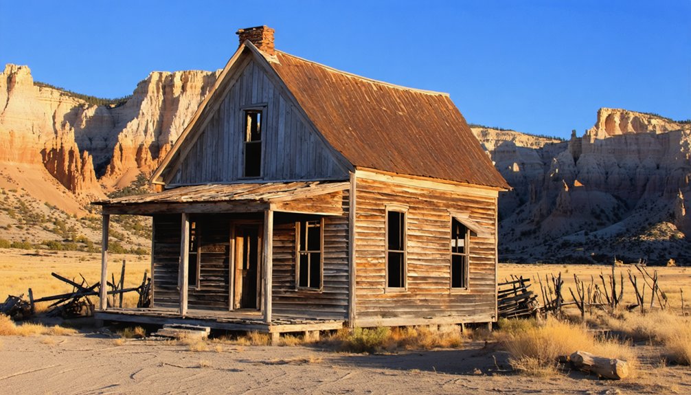
Widtsoe Ghost Town: A Testament to Drought and Perseverance
Nestled in Johns Valley northeast of Bryce Canyon National Park, Widtsoe Ghost Town stands as a stark reminder of agriculture’s fragility in Utah’s high desert.
You’ll find this semi-abandoned settlement along the Sevier River at Sweetwater Creek’s mouth, accessible via Johns Valley Road toward Antimony.
Widtsoe history began in 1876 with Mormon ranchers, though formal establishment occurred around 1908. Named after Dr. John A. Widtsoe, the town championed dry farming techniques he promoted.
Brief prosperity followed in the 1920s as optimistic settlers built homes and infrastructure.
Severe drought impact from the 1920s through 1930s proved catastrophic. Persistent water shortages destroyed crops and forced residents to abandon their dreams by 1936.
The community’s struggles were compounded by a twenty-year cycle of drought and water abundance that made reliable farming nearly impossible.
The Resettlement Administration purchased local holdings in 1935, leading to the town’s official dissolution and relocation of remaining families.
Today, you’ll discover stone foundations and ranch remnants that symbolize determined pioneers who challenged—and ultimately surrendered to—environmental hardship.
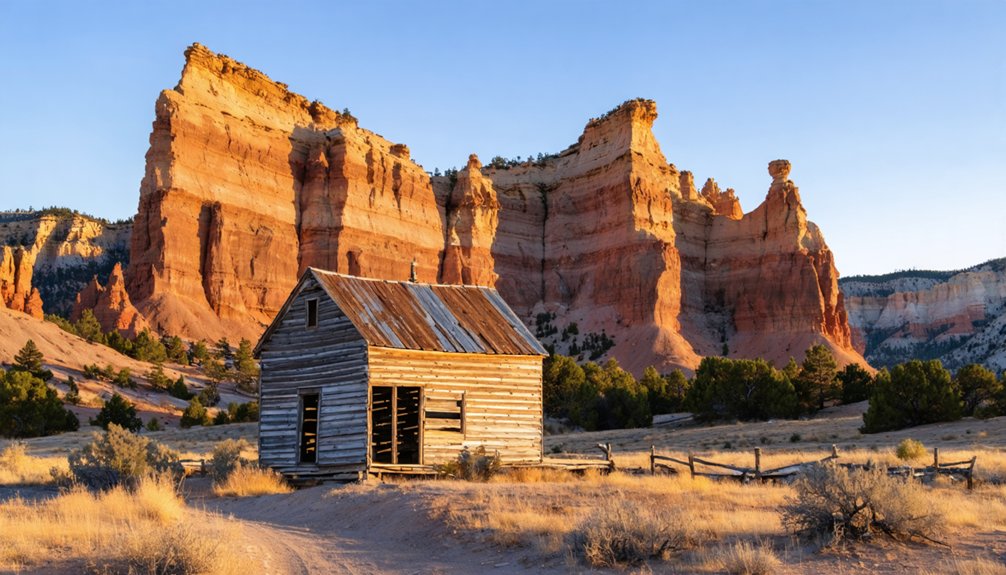
Osiris Ghost Town: Riverside Remnants and Historic Mills
You’ll find Osiris Ghost Town ten miles south of Antimony, Utah, where three primary structures anchor this 1910 settlement along the Sevier River’s east fork.
The stone-and-concrete mill serves as the centerpiece, complemented by a deteriorating barn and a creamery-granary complex with towering silos—all remnants of WF Holt’s ambitious 1920s development of the former Henderson Ranch.
Located within Black Canyon near Otter Creek State Park, this BLM-managed site offers quick roadside exploration approximately 20 minutes off the standard Salina-to-Bryce Canyon route.
The buildings are fenced off with No Trespassing signs, limiting close access to the structures.
The town officially closed in the early 1930s after climate issues similar to those affecting nearby Widtsoe led to its abandonment.
Mill Structure and Architecture
The stone-and-concrete grain mill stands as Osiris’s most substantial surviving structure, its massive integrated silos rising above the East Fork of the Sevier River where W.E. Holt established this grain-processing operation following his arrival from Widtsoe.
The mill architecture reflects practical frontier engineering, built to withstand Black Canyon’s harsh elements through durable stone-and-concrete construction methods.
The complex’s historical significance centers on three key features:
- Massive integrated silos designed for grain storage capacity
- Large metal tank with continuous water stream channeling
- Man-made water diversion system behind the property
You’ll find the centerpiece mill building demonstrates how early settlers harnessed the river’s power for agricultural processing.
The granary portion features thick wooden beams and solid stairs that remain structurally sound despite decades of abandonment.
Though fenced with posted no-trespassing signs, this riverside complex reveals the ambitious scope of Osiris’s brief farming era during the 1920s.
Visitors can view the mill from a narrow trail that provides safe vantage points of the historic structure.
Riverside Location and Views
Osiris occupies a dramatic riverside setting along the east fork of the Sevier River in Black Canyon, approximately 10 miles south of Antimony in Garfield County.
You’ll find this abandoned settlement near Otter Creek State Park, where golden light illuminates the historic landscape during late afternoon hours. The river provided essential water resources for the community’s industrial operations, though insufficient flow prevented reliable crop cultivation—ultimately contributing to the town’s abandonment within a decade of its 1910 establishment.
During riverside exploration, you’ll notice a constant stream flowing from the creamery’s large metal tank, while man-made channels beneath stone walls once directed water throughout the property.
The surrounding terrain features golden grasslands and open hillsides characteristic of Utah’s high desert, creating scenic views just twenty minutes from Bryce Canyon National Park. W. E. Holt from nearby Widtsoe established both a creamery and flour mill at the site, constructing the industrial infrastructure that defined the settlement’s brief economic activity. The site’s most impressive granary stands as a testament to the agricultural ambitions that drove the community’s development during the 1910s and 1920s.
Access and Nearby Attractions
From State Route 22, this historic settlement appears 10 miles south of Antimony as a striking stone-and-concrete mill complex that looms over the roadway.
You’ll find multiple access routes converge here, making it an easy addition to your Bryce Canyon journey. Taking the scenic drive from Salina through Garfield County adds just 20 minutes to your route while passing Otter Creek State Park.
Three nearby attractions worth exploring:
- Otter Creek State Park offers fishing and camping facilities just north of Antimony
- Widtsoe Cemetery sits 15 miles south, clearly marked from the highway
- Black Canyon surrounds the site with stream access for anglers
The property’s fenced structures prevent interior access, but you can circle the mill’s exterior during daylight hours. The Holt family constructed the creamery that gave this settlement its name and purpose as a dairy processing center. The site was officially founded in 1920 after Holt purchased the original Henderson Ranch.
Most visitors spend thirty minutes examining the three surviving buildings from the road.
Old Irontown Ruins: Industrial Heritage of Mormon Pioneers
Nestled along Iron Town Road approximately 20 miles west of Cedar City, Old Irontown stands as a symbol of Mormon pioneers‘ ambitious industrial endeavors in southwestern Utah. Founded in 1868 under Brigham Young’s direction, this settlement represented industrial innovation through its charcoal-fueled iron production.
You’ll discover well-preserved beehive kilns that once processed juniper and pinyon pine, alongside remnants of the foundry’s chimney and arastra grinding stone.
The site operated for seven years, producing iron for settlers, railroads, and local needs before closing in 1876. Two quarter-mile trails feature interpretive plaques explaining the manufacturing process and pioneer resilience.
Listed on the National Register of Historic Places since 1971, Irontown’s ruins preserve southwestern Utah’s mining heritage, demonstrating both the determination and ultimate challenges faced by Mormon industrial pioneers.
Grafton Ghost Town: Short-Lived Settlement Near Zion
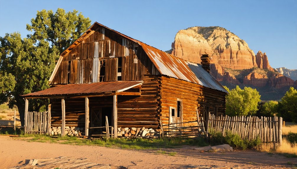
You’ll find Grafton Ghost Town nestled along the Virgin River floodplain just seven miles from Springdale, where Mormon settlers led by Nathan Tenney established this community in 1859.
The settlement grew rapidly to 160 residents by 1866, becoming the largest town in the upper Virgin River valley.
However, this prosperity was short-lived—devastating floods forced relocation in 1862, and Southern Paiute attacks, including the killing of three Berry brothers on April 2, 1866, led to the first abandonment that same year.
Mormon Pioneer Origins
In 1859, Nathan Tenney led five families—the Barneys, Davies, McFates, Platts, and Shirts—from the nearby settlement of Virgin to establish Grafton approximately one mile downstream from its present location.
This pioneer community became part of Brigham Young’s ambitious territorial expansion, which established 500 Mormon settlements between 1847 and 1900 to solidify the church’s claim to Deseret.
The settlement served three critical purposes:
- Cotton Mission fulfillment – Cultivating cotton for economic self-sufficiency during Civil War shortages
- Early agriculture development – Constructing cooperative irrigation ditches and planting communal crops
- Territorial expansion – Strengthening Mormon presence in Utah Territory’s Virgin Valley region
Flood and Abandonment
Within three years of its founding, Grafton’s original settlement met a catastrophic end when the Virgin River flooded in 1862, completely washing away the crops and homes the five founding families had built on the floodplain.
The flood impacts forced temporary abandonment as survivors relocated one mile downstream to higher ground, demonstrating remarkable community resilience. However, their challenges had only begun.
By 1866, escalating conflicts during the Black Hawk War proved devastating—raiders killed the Berry brothers and wife on April 2, 1866, forcing complete evacuation. The settlement stood empty until peace returned in 1868.
Though residents rebuilt and grew cotton and wheat on fertile soils, the Virgin River’s unpredictable flooding continued destroying crops and clogging irrigation ditches with silt, ultimately contributing to Grafton’s final abandonment in 1944.
Sego Canyon Ghost Town: Where History Meets Ancient Art
Although Sego Canyon‘s mining operations have long ceased, this remote ghost town 25 miles northeast of Thompson Springs stands as a dual tribute to both industrial ambition and ancient human presence.
Harry Ballard’s 1890s coal discovery sparked development that peaked under the American Fuel Company in 1911, creating a self-sustaining community that thrived until 1947.
What makes Sego History compelling:
- Ancient Artifacts – Thousands of well-preserved petroglyphs and pictographs adorn canyon walls, depicting human figures, animals, and abstract symbols.
- Industrial remnants – One brick building survives alongside collapsed wooden structures and visible railroad grades.
- Pioneer graveyard – A small fenced cemetery preserves headstones and unmarked graves reflecting early settler hardships.
You’ll need high-clearance vehicles for deeper canyon exploration, where mining heritage and ancient rock art converge.
Thistle Ghost Town: Utah’s Modern Submerged Settlement
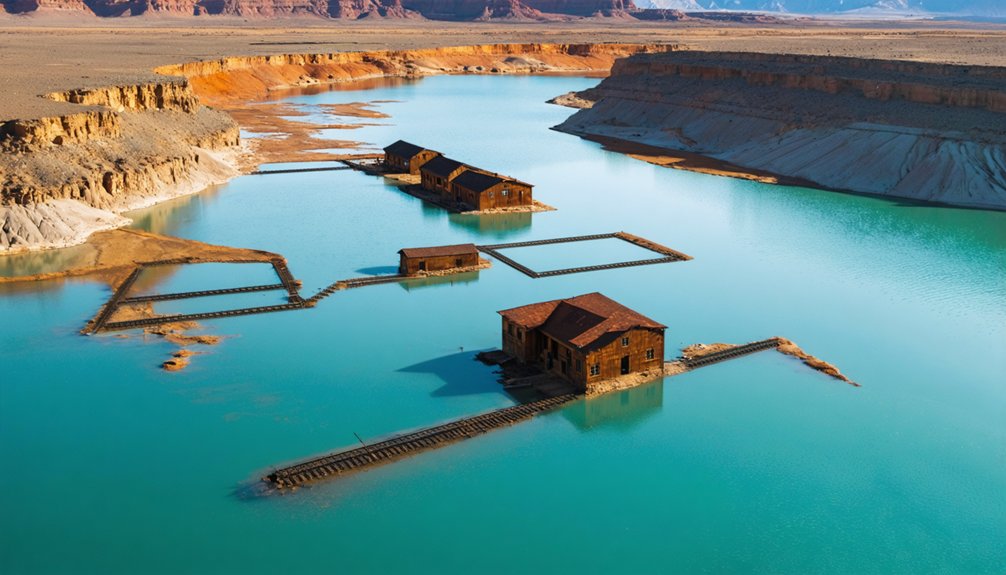
Thistle’s transformation from thriving railroad community to submerged settlement occurred within days rather than decades, making it Utah’s most dramatic modern ghost town.
You’ll discover a settlement founded in 1848 that peaked at 600 residents, serving as a critical railroad hub until diesel engines eliminated its strategic importance in the 1950s.
The landslide impact in 1983 created America’s costliest geological disaster. Record precipitation and snowmelt triggered a massive earthflow, forming a 220-foot dam that created Thistle Lake.
Residents received just two hours to evacuate before water submerged their homes under 50 feet.
Today, you’ll find only one partially-submerged homestead visible—a stark reminder of how quickly natural forces can erase human settlement.
This Thistle history exemplifies nature’s ultimate authority over civilization.
Planning Your Ghost Town Adventure Near Bryce Canyon
While Thistle’s story demonstrates nature’s power to reclaim settlements in moments, exploring Utah’s older ghost towns near Bryce Canyon requires careful planning to navigate their remote locations safely.
Understanding ghost town logistics guarantees you’ll maximize your adventure while maintaining travel safety on unpaved roads.
Essential preparation for your ghost town expedition:
- Route Planning – Combine Widtsoe via Highway 22 northeast of Bryce, Osiris along the scenic river approach, or detour west to Old Irontown from Cedar City.
- Vehicle Readiness – Expect rocky, bumpy dirt roads requiring clearance for remote access to sites like Widtsoe’s remnants.
- Safety Supplies – Carry water, visit during daylight hours, and check weather conditions before departing.
Pick up informational brochures at Cedar City’s museum for detailed site maps and historical context.
Best Times to Visit Ghost Towns in Southern Utah
Timing your ghost town exploration greatly impacts your experience, as southern Utah’s desert climate creates vastly different conditions throughout the year.
Spring exploration brings mild temperatures and reduced crowds at both Bryce Canyon and nearby ghost towns like Grafton, where morning visits offer comfortable conditions.
In addition to the scenic views of Bryce Canyon, the ghost towns surrounding Hot Springs National Park provide a glimpse into the area’s rich history. Each town has its own unique story, often with remnants of old mining operations and structures that have stood the test of time. Exploring these sites adds an adventurous element to any trip, allowing visitors to connect with the past while enjoying the natural beauty of the region.
Spring delivers ideal ghost town exploration conditions with pleasant temperatures, fewer visitors, and prime morning hours for discovering Grafton’s historic structures.
Fall tranquility rivals spring, with shoulder-season visitation creating peaceful experiences at historic sites.
Winter months see only 9% of annual park traffic, providing snow-dusted landscapes but requiring preparation for cooler conditions.
Summer’s extreme heat demands early morning or post-sunset visits, particularly at exposed sites like Silver Reef where rattlesnakes emerge during warm months.
You’ll find year-round access to most ghost towns, though recent rain can affect dirt road conditions to sites like Grafton.
What to Bring When Exploring Ghost Towns
Proper preparation separates safe ghost town exploration from potentially dangerous situations, making your packing list as crucial as your destination choice.
Essential gear protects you from hazards common in abandoned structures while enabling thorough exploration.
Core Safety Precautions Equipment:
- Protective Clothing – Cut-resistant gloves shield hands from rusty surfaces and debris, while sturdy boots provide ankle support on uneven terrain. Long-sleeved shirts and pants protect against thorns and sharp edges.
- Lighting Systems – Pack two powerful flashlights per person with spare batteries. A headlamp enables hands-free navigation through dark interiors where structural hazards hide.
- Emergency Supplies – First-aid kit, multi-tool, water bottle, and whistle handle injuries and unexpected situations in remote locations.
Your backpack should organize these items efficiently, ensuring quick access when exploring Southern Utah’s historic sites.
Frequently Asked Questions
Are Any Ghost Towns Near Bryce Canyon Accessible During Winter Months?
Yes, you’ll find winter accessibility at Widtsoe Ghost Town via year-round Highway 22 and Old Irontown’s maintained historical park. Both offer rich ghost town history without seasonal closures, though you should prepare for high desert winter conditions.
Can I Camp Overnight at Any of These Ghost Town Sites?
No overnight camping’s permitted at these locations. Ghost town amenities are virtually nonexistent, and camping regulations designate them as day-use only. You’ll need to find nearby dispersed camping or established campgrounds for overnight stays instead.
Are the Ghost Town Structures Safe to Enter and Explore Inside?
You’ll find no explicit entry bans, but structural integrity isn’t guaranteed at these aging sites. Exercise safety precautions—these aren’t maintained buildings. Old Irontown’s park status offers more stability, though caution remains essential when exploring any historic structures.
Do I Need a High-Clearance Vehicle to Reach These Ghost Towns?
You won’t need a high-clearance vehicle for most ghost towns near Bryce Canyon. Standard passenger cars can access Widtsoe, Old Irontown, and Sego Canyon via maintained roads, though vehicle recommendations vary for more remote locations requiring careful route planning.
Are Pets Allowed at Ghost Town Sites Near Bryce Canyon?
You’ll find no specific pet restrictions at these ghost towns, though pet-friendly policies aren’t formally documented. Practice pet safety by keeping animals leashed, respecting private property boundaries, and bringing water since no amenities exist on-site.
References
- https://www.utahsadventurefamily.com/5-ghost-towns-in-utah-for-families/
- https://trucenow.com/ghost-towns-near-bryce-canyon/
- https://www.tripadvisor.com/Attraction_Review-g56943-d6677841-Reviews-Widtsoe_Ghost_Town-Bryce_Utah.html
- https://www.visitutah.com/things-to-do/history-culture/ghost-towns
- https://inspiredimperfection.com/adventures/widtsoe-ghost-town/
- https://ronmayhewphotography.com/2022/04/10/widtsoe-utah-a-ghost-town/
- https://www.allbryce.com/history_museums/old_irontown_ruins.php
- https://www.youtube.com/watch?v=nE194sc6xXE
- https://en.wikipedia.org/wiki/Widtsoe
- https://www.dialoguejournal.com/articles/telling-the-tales-and-telling-the-truth-writing-the-history-of-widtsoe/


