You’ll find several fascinating ghost towns within a few hours’ drive of Carlsbad Caverns. Salt Flat, 90 miles west on Highway 62/180, was a thriving bus stop that declined after its post office closed in 2004. Orla sits along Highway 285 as a near-ghost town with fewer than 50 residents, abandoned when the Pecos Valley Railroad shut down in 1990-1991. Glenrio, straddling the Texas-New Mexico border, preserves 17 Route 66-era buildings frozen since Interstate 40’s completion. Each site offers unique insights into the region’s transportation history.
Key Takeaways
- Salt Flat, established in 1929, thrived as a highway stop to Carlsbad Caverns before its post office closed in 2004.
- Orla served as a Pecos Valley Railroad section house from 1890 until abandonment in 1990-1991, now housing fewer than 50 residents.
- Glenrio straddles the Texas-New Mexico border along Route 66, featuring 17 abandoned buildings preserved as a Historic District.
- Plan a 180-200 mile loop with full fuel tanks, ample water, and offline navigation for sparse desert conditions.
- Respect private property boundaries and beware of structural hazards, extreme heat, and desert wildlife when exploring.
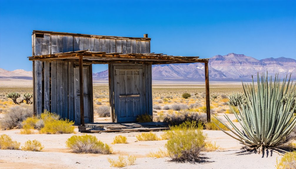
Salt Flat: A Highway Town Frozen in Time
In 1928, rancher’s son Edwin Hammack seized opportunity when he learned a new highway to Carlsbad Caverns would cross the flats. He built a store and gas station that opened in 1929, creating a crucial bus stop.
Rival Arthur Grable added competing services, and both expanded into cafés and tourist courts. That highway nostalgia lingers today, though the population peaked at 125 in the early 1960s before decline set in.
The town’s post office permanently closed in January 2004, marking another chapter in Salt Flat’s transformation into a ghost town. Exploration of the abandoned convenience store and cafe reveals numerous beer bottles and derelict buildings that reflect the town’s gradual decline.
Orla: Railroad Remnants on the Pecos Valley Line
You’ll find Orla tucked along Highway 285 north of Pecos, a settlement born in 1890 as a section house on the Pecos Valley Railroad line that once connected the Texas oil country to Carlsbad and Roswell.
The town’s original purpose—maintaining track for trains hauling freight and passengers through the Pecos corridor—vanished when the railroad abandoned this route in 1990–1991, leaving behind scattered structures and building foundations that mark where rail crews once lived and worked.
Today Orla exists as a near-ghost town with fewer than 50 residents, accessible via the main highway but stripped of the railroad infrastructure that created it over a century ago.
The region’s rail history extends beyond this single line, as the nearby Pecos Valley Southern Railway Company, chartered in 1909, operated a 45-mile route from Pecos to Toyahvale before abandoning eleven miles of track between Saragosa and Toyahvale in 1971. The railway was purchased by Texas & Pacific in 1927 to serve as a freight feeder, connecting local agricultural and industrial shippers to the larger rail network.
1890 Railroad Origins Story
Before Orla became a ghost town on the Texas plains, it owed its very existence to one of the Southwest’s boldest turn-of-the-century schemes: James J. Hagerman’s integrated railroad and irrigation empire.
The Pecos River Railroad Company, chartered March 1, 1890, formed the backbone of this venture’s railroad history.
The system’s ambitious scope included:
- 54-mile line from Pecos City to the New Mexico border
- $750,000–$1,750,000 capitalization from Colorado investors and Swiss bankers
- January 1, 1891 opening connecting Pecos Valley farms to Texas & Pacific markets
- Standard-gauge track hauling lumber, cement, and machinery for dam construction
You’ll find Orla emerged as a station point along this corridor, serving the sparsely settled ranching country between Pecos and Carlsbad.
The railroad extended northward, reaching Eddy (Carlsbad) in 1891 and continuing to Roswell the following year as part of the Pecos Valley Railway’s expansion through southeastern New Mexico.
The Pecos River Railroad’s business office in Pecos served as the administrative hub for operations that generated $3,193 in passenger revenue and $12,837 in freight revenue during its first year of service.
Abandoned Buildings and Structures
A weathered roadbed traces a lonely arc across the West Texas scrubland where Orla’s lifeblood once ran on steel rails. The Pecos Valley Railway abandoned this segment around 1990, yet you’ll find concrete footings, loading platform remnants, and gravel ballast still marking the right-of-way.
These abandoned structures tell the story of a freight corridor that linked ranchers and farmers to distant markets. Foundation pads reveal where the depot and section houses stood, while scattered pier blocks indicate tool sheds that supported track maintenance crews.
The historical significance lies in how this modest branch line opened isolated rangeland to irrigation agriculture and commerce. Before discontinuation, the line hosted the Pecos Valley Streamliner, a passenger service that connected Carlsbad to Clovis across 183.7 miles until shortly after 1967. If access issues arise when researching the site, visitors should consult with the administrator of the surrounding ranchland for proper permissions. Today, berms and drainage ditches remain visible across ranchland, preserving the railroad’s linear trace even after the tracks vanished.
Current Population and Access
- Post office maintaining federal recognition
- Highway 285 and FM 652 junction providing road access
- Pipeline interconnections and crude gathering systems
- Temporary workforce housing for energy sector employees
- Population stands at fewer than 60 residents, reflecting the area’s transition from agricultural settlement to energy industry outpost
Population data for New Mexico communities is sourced from the U.S. Census Bureau, with estimates updated through July 2024.
You can reach Orla easily via U.S. 285 between Pecos and Carlsbad, though you’ll encounter more energy infrastructure than historic buildings along this forgotten Pecos Valley corridor.
Glenrio: Route 66’s Border Ghost on the Texas-New Mexico Line
Few ghost towns capture the romance of Route 66 quite like Glenrio, a tiny settlement straddling the Texas-New Mexico border where travelers once paused between Amarillo and Tucumcari. Founded in 1901, the town’s railroad history established it as a crucial stop for wheat and cattle ranchers.
During Route 66’s heyday, Glenrio thrived with motels, diners, and the iconic Streamline Moderne Texaco station where cars lined up for hours.
The 1955 railroad depot closure and Interstate 40’s completion in 1973 devastated the community, routing traffic away from this once-bustling waypoint.
Today, you’ll find 17 abandoned buildings preserved as a Historic District, including the State Line Motel with its reversible “First in Texas” or “Last in Texas” sign—perfect for those seeking authentic Americana off the beaten path.
Southern New Mexico Mining and Railroad Ghost Sites
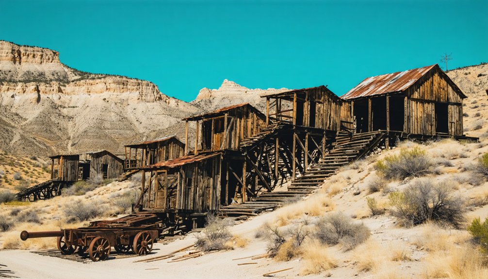
Mining fever transformed southern New Mexico’s arid landscapes into bustling industrial centers throughout the late 1800s and early 1900s, leaving behind a remarkable collection of ghost towns that tell the story of copper, silver, zinc, and gold extraction in one of the West’s most productive mineral regions.
Your southern New Mexico mining ghost town exploration reveals:
- Lake Valley – Founded in 1878 after discovering exceptionally high-grade silver ore, now preserved as a BLM historic site with stabilized buildings and interpretive trails.
- Tyrone – Phelps Dodge’s model company town southwest of Silver City, largely consumed by open-pit copper mine expansion.
- Hanover-Fierro – Interconnected zinc and copper camps north of Bayard, featuring abandoned structures along Hanover Creek.
- Old Hachita – Remote desert copper-silver-zinc camp displaying adobe ruins and mining debris across ranch lands.
Planning Your Ghost Town Road Trip From Carlsbad Caverns
Before heading out from Carlsbad Caverns to explore ghost towns like Salt Flat, you’ll need to plan carefully for the sparse desert environment.
The 180–200 mile loop along US-62/180 requires full fuel tanks, ample water, and offline navigation tools, since services and cell coverage are inconsistent between Carlsbad and the Texas state line.
Understanding property boundaries and road conditions will keep you safe while maximizing your photography opportunities at these remote ruins.
Essential Supplies and Fuel
Planning a ghost town exploration from Carlsbad Caverns requires careful preparation due to the remote nature of southeastern New Mexico’s backcountry.
You’ll need to account for limited fuel availability and sparse supply routes when venturing into Eddy County’s abandoned mining communities.
Before departing, guarantee you have:
- Full fuel tank – Gas stations become scarce once you leave Carlsbad’s main corridors
- Emergency water supply – Pack at least one gallon per person for desert conditions
- Navigation tools – GPS devices and physical maps, as cell service is unreliable
- Vehicle essentials – Spare tire, jack, and basic repair tools for unpaved roads
Stock up on provisions in Carlsbad before heading out.
The isolation that makes these ghost towns fascinating also means you’re truly on your own once you leave civilization behind.
Best Driving Routes
With your vehicle packed and ready, the next step is mapping out efficient routes to reach southeastern New Mexico’s ghost towns from Carlsbad Caverns.
You’ll find Salt Flat accessible via Highway 62/180, approximately 90 miles west toward El Paso, where preserved abandoned buildings showcase the town’s historical significance as a 1920s highway stop.
For Steins and its local legends of murder mysteries, head southwest on I-10, where visible railroad ruins mark this former stop.
Glenrio requires a northern route along old Route 66, straddling the Texas-New Mexico border with its intact 1940s-era structures.
Dripping Springs sits near Las Cruces, offering hiking trails through Organ Mountains to 19th-century resort ruins.
Plan fuel stops carefully—these remote locations demand self-sufficiency and preparation for long stretches between services.
Safety and Property Considerations
Although ghost towns offer compelling windows into New Mexico’s frontier past, exploring them safely requires you to navigate a complex landscape of property rights and physical hazards. Many sites sit on private ranchland or patented mining claims where trespassing laws classify unauthorized entry as a misdemeanor—even if structures appear abandoned.
Before visiting, consider these critical safety factors:
- Property boundaries: Respect purple paint markers, fencing, and posted signs indicating private ownership.
- Structural risks: Rotted floors, unstable roofs, and hidden mine shafts create collapse and fall hazards.
- Environmental hazards: Rattlesnakes, scorpions, and hantavirus-carrying rodents inhabit shaded structures and debris.
- Desert conditions: Extreme heat, flash floods, and remote locations demand water, navigation tools, and emergency communication.
Photograph from public rights-of-way and never enter fenced areas or buildings without permission.
What to Expect When Exploring Desert Ghost Towns
Desert ghost towns offer fascinating windows into the past, but they’re not curated museums—they’re raw, exposed sites where nature and time have reclaimed what miners and settlers left behind.
Exploring ghost towns around Channel Islands can be equally enchanting, revealing remnants of human endeavor against a backdrop of stunning coastal landscapes. With the waves crashing nearby and the salty breeze in the air, these sites tell stories of ambition and abandonment. Each visit allows one to reflect on the fleeting nature of existence and the enduring power of the elements.
These aren’t preserved exhibits—they’re unfiltered historical sites where decay and wilderness have overtaken abandoned settlements.
You’ll encounter crumbling adobe walls, rusty mining equipment, and weathered wooden structures in various stages of collapse. The desert environment presents real challenges: daytime temperatures exceeding 110°F demand solid desert survival skills, including adequate water and sun protection.
Wildlife awareness is essential—rattlesnakes shelter in foundations and rock piles, while scorpions inhabit crevices and doorframes. Expect unstable footing around tailings piles, hidden mine shafts obscured by brush, and dramatic temperature swings that can drop below 50°F at night.
These aren’t sanitized attractions; they’re authentic remnants requiring self-reliance and respect.
Frequently Asked Questions
Are Any Ghost Towns Near Carlsbad Caverns Still Legally Inhabited?
Yes, you can legally live in several nearby “ghost towns” with inhabited buildings that retain historical significance. New Mexico treats “ghost town” as a tourism label, not a legal restriction, so property owners maintain normal residency rights under county regulations.
Can I Camp Overnight at Salt Flat or Other Ghost Towns?
You can’t legally camp at Salt Flat—it’s private property with zero ghost town amenities. Instead, you’ll find freedom at nearby BLM lands or designated sites where camping regulations actually permit overnight stays.
Which Ghost Town Is Closest Driving Distance to Carlsbad Caverns?
Salt Flat’s your closest option, located roughly 90 miles from Carlsbad Caverns along the main highway corridor. You’ll find driving routes connecting El Paso to the park, passing this settlement with historical significance from 1930s aviation emergency services.
Do Any Ghost Towns Charge Entrance or Photography Fees?
You’ll find freedom to explore without opening your wallet—these ghost towns don’t charge entrance fees or impose photography restrictions. Salt Flat, Orla, and Glenrio remain accessible for documentation, though you should respect private property boundaries.
Are Ghost Town Structures Safe to Enter or Explore Inside?
Most ghost town structures aren’t safe to enter due to serious safety concerns including deteriorating structural integrity, unstable floors, toxic materials like asbestos, and potential collapse. You’ll find safer alternatives through exterior viewing and guided tours.
References
- https://nuttyhiker.com/ghost-town-salt-flat-texas/
- https://newmexicotravelguy.com/new-mexico-ghost-towns/
- https://www.newmexico.org/places-to-visit/ghost-towns/
- https://klaq.com/glenrio-ghost-town-texas-new-mexico/
- https://www.thedearbobandsuepodcast.com/139-ghost-towns-of-the-national-parks/
- https://www.npca.org/articles/821-9-spooky-national-park-sites
- https://www.scoutingny.com/nm-to-tx-white-sands-rockets-visiting-a-true-ghost-town-a-very-special-grave/
- https://www.youtube.com/watch?v=_DizImYWjw0
- https://www.legendsofamerica.com/salt-flat-texas/
- https://www.youtube.com/watch?v=0es4BPUPS68


