You’ll find Virginia City just 20 minutes north of Carson City—the crown jewel of Nevada’s ghost towns, where 25,000 miners once worked the legendary Comstock Lode. Fort Churchill’s crumbling adobe barracks sit 40 miles east along US-50, while Pine Grove’s intact Joshua Hendy stamp mill awaits two hours southwest on graded dirt roads. The remote Seven Troughs District and Berlin-Ichthyosaur State Park offer even more adventurous exploration combining mining relics with paleontological wonders. Each site requires different preparation levels, from paved highway access to serious backcountry navigation.
Key Takeaways
- Fort Churchill State Historic Park, 40 miles east via US-50, features adobe ruins from an 1860s military outpost protecting emigrants.
- Old Washoe City lies 20 minutes north of Carson City, offering excellent sunrise photography opportunities at a historic settlement.
- Virginia City and Gold Hill, sites of the 1859 Comstock Lode discovery, once housed 25,000 residents with 110 saloons.
- Pine Grove in the Wilson Mining District features a well-preserved hotel and 5-stamp Joshua Hendy mill on original foundations.
- Berlin-Ichthyosaur State Park in the Shoshone Mountains combines a 1890s mining camp with a 30-stamp mill and fossil deposits.
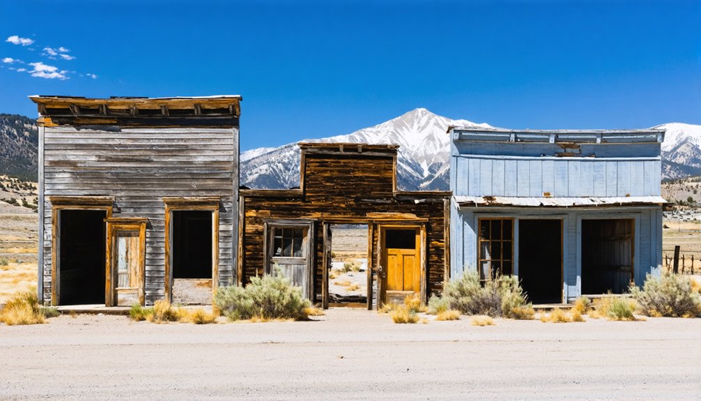
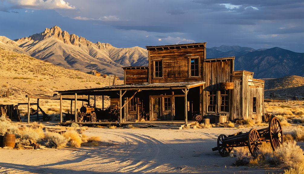
Virginia City and Gold Hill: The Legendary Comstock Lode Boomtowns
When prospectors struck silver-gold ore above Gold Canyon in January 1859, they couldn’t have imagined they’d just uncovered the Comstock Lode—one of the world’s richest mineral deposits, buried beneath Mount Davidson’s eastern slope in Nevada’s Virginia Range.
The “Rush to Washoe” transformed Virginia City and Gold Hill into industrial powerhouses, their combined population swelling to nearly 25,000 by the early 1870s.
This wasn’t your typical frontier settlement—Virginia City’s downtown boasted 110 saloons, multiple theaters, and a six-story hotel with the only elevator west of Chicago.
The Boomtown Culture attracted immigrants from everywhere: Irish workers, Cornish miners, over 1,500 Chinese residents, and union miners earning $4 daily—the nation’s highest industrial wage—working 3,000 feet beneath the streets.
The wealth generated from Virginia City’s mines contributed significantly to the U.S. government’s finances during the Civil War, helping to fund the Union cause.
Gold Hill became the first town established on the Comstock Lode, where early inhabitants lived in canvas tents or dugouts while businesses operated from temporary structures, eventually growing to a peak population of around 8,000 by 1877.
Fort Churchill State Historic Park: Adobe Ruins Along the Carson River
You’ll discover Fort Churchill’s roofless adobe barracks standing in “arrested decay” about an hour east of Carson City, where the U.S. Army’s first Nevada outpost once protected emigrants and Pony Express riders from 1860 to 1869.
The CCC stabilized these crumbling walls in the 1930s rather than rebuild them, preserving the authentic texture of abandonment that defines a true ghost site.
Today you can walk among the squared-off adobe ruins, camp under cottonwoods along the Carson River, and hike the Nature Trail connecting the fort to historic Buckland Station through 3,200 acres of high-desert corridor. The fort also served as Nevada Pony Express Station No. 32, providing a crucial home station along the legendary mail route. Anglers can enjoy catch-and-release fishing for walleye, catfish, and trout along the Carson River.
Military Outpost Becomes Ruins
Perched on the north bank of the Carson River roughly twenty-five miles east of Carson City, the crumbling adobe walls of Fort Churchill stand as haunting reminders of Nevada’s brief but pivotal military era.
You’ll walk among the skeletal remains of what Captain Joseph Stewart built in 1860–1861 to protect emigrants and supply lines during the Pyramid Lake War. The military history here is visceral—parade grounds where cavalry drilled, officers’ quarters now reduced to shoulder-high walls, barracks open to the desert sky.
When the Army abandoned the fort in 1869, auctioneers sold everything for $750. The adobe architecture couldn’t withstand such pillaging. Rancher Samuel Buckland hauled away lumber to build his station downstream.
What remains today exists in “arrested decay”—stabilized but intentionally unrestored, preserving authenticity over reconstruction. The Civilian Conservation Corps stabilized these ruins and established park facilities in 1935, ensuring future generations could witness this fragment of frontier military life. Beyond the ruins, the park sprawls across 3,200 acres of Carson River bottomland, offering camping, hiking, and birdwatching opportunities for visitors.
Adobe Barracks and Structures
The adobe walls you’ll encounter at Fort Churchill tell their own story through material and method. Built in 1860–61 using riverine clays, Carson River water, and straw binders, these sun-dried bricks formed thick earthen masses that regulated temperature naturally—cool summers, warm winters.
Army troops and civilian workers shaped nearly two dozen structures around a 13-acre parade ground: barracks, officers’ quarters, storerooms, hospital. Adobe construction techniques reflected practical adaptation where timber and stone were scarce.
Today’s roofless wall segments and softened corners reveal Nevada’s high-desert climate at work. Since the 1930s Civilian Conservation Corps interventions, historical adobe preservation has maintained “arrested decay”—stabilizing drainage and structure without reconstruction, letting you witness authentic frontier military architecture weathering gracefully. The National Park Service guided the stabilization of adobe ruins, ensuring period-appropriate techniques preserved the fort’s authenticity. The fort occupied 1,384 acres on the Carson River’s north bank during its nine years of active military service.
Recreation and Exploration Opportunities
Beyond exploring the adobe ruins themselves, Fort Churchill State Historic Park unfolds across 3,200 acres of Carson River corridor that invite you to wade, paddle, hike, and camp where military supply wagons once forded.
You’ll find hand-carry launch sites for canoes and kayaks when seasonal flows permit—check USGS data before heading out. The 2.2-mile Nature Trail parallels the river through cottonwood groves to Buckland Station, extending farther downstream through Carson River Ranches for multi-day backpacking trips.
Twenty improved campsites nestle beneath riverside cottonwoods near the fort, plus primitive sites downstream. River activities blend seamlessly with birding along hiking trails, where you can spot riparian species against desert hills. The Nevada Civil War Volunteers host living history encampments at the fort, bringing the site’s military past to life through period demonstrations.
The corridor links directly to Lahontan State Recreation Area, opening longer paddling and equestrian routes through Nevada’s high desert.
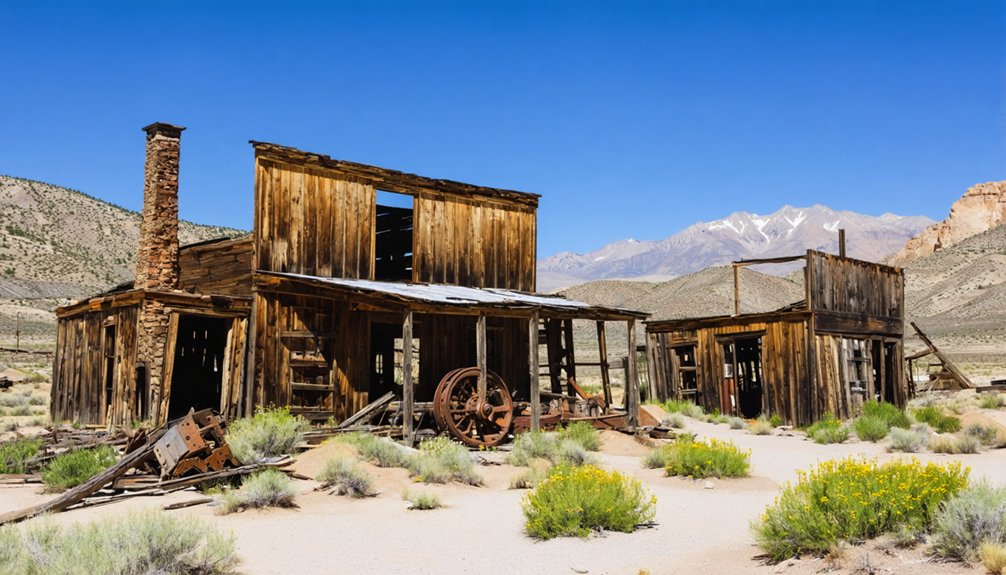
Pine Grove: A Classic Mining Camp in Mason Valley
When you drive into Pine Grove Canyon, you’re entering the site of one of Lyon County’s most successful gold camps—discovered by William Wilson in 1866 and home to over 600 miners at its 1870s peak.
The combined Wilson and Wheeler mines produced more than $8 million in bullion before decline set in during the 1890s, yet you’ll still find scattered cabin foundations, mill ruins, and mine adits clinging to the hillsides.
Access requires a high-clearance vehicle on the old wagon road that crosses Pine Grove Summit, but the remote location has helped preserve what remains of this once-thriving town.
The town sits at an elevation of 6,716 feet in the rugged terrain of the Pine Nut Mountains, where winter snows and summer heat shaped the harsh conditions faced by early prospectors.
1866 Discovery & Growth
Gold fever struck the Pine Grove Hills in 1866 when William Wilson, a Mason Valley resident, uncovered promising ore in a remote canyon—and with that single discovery, he set in motion the creation of what would become one of Nevada’s most enduring mining camps.
Within months, prospectors established the Wilson Mining District and built Wilsonville around those first north-side outcroppings. You’ll find the name Pine Grove appeared in 1868, borrowed from nearby piñon groves where Native Americans had gathered pine nuts for generations.
Surviving Structures & Access
That mining legacy left behind one of Nevada’s most rewarding ghost town sites to explore.
You’ll find Pine Grove’s surviving buildings scattered across three distinct clusters along the canyon, including a remarkably intact hotel and weathered wood-frame structures that’ve defied decades of high-desert exposure.
The highlight is a well-preserved 5-stamp Joshua Hendy mill standing on its original foundation—one of western Nevada’s finest industrial relics.
Rock walls from the old store still frame the main information area, while mill foundations mark processing sites below.
The cemetery features sit south of the hotel on the canyon rim, offering views across the valley where miners once labored.
Stone ruins, scattered machinery, and mine openings throughout the hillsides complete this authentic ghost town experience you can explore freely.
The Seven Troughs District: Remote Mining Relics in the Desert
Deep in Pershing County’s high desert, about 30 miles northwest of Lovelock, the Seven Troughs District sprawls across a rugged canyon system where one of Nevada’s richest—if briefest—gold rushes unfolded in the early 20th century.
When blacksmith Joe Therien discovered ore here in 1905, assays hit six figures per ton. By 1907, 5,000 fortune-seekers swarmed three boomtowns built around the legendary Kindergarten vein.
You’ll find remnants of ambitious mining technology throughout the canyon: the 10-stamp Kindergarten Mill’s foundations, the Coalition Cyanide Plant’s concrete shells, and miles of flooded underground workings.
A catastrophic 1917 water inflow at 1,600 feet killed the boom overnight. Today, leach ponds, scattered artifacts, and crumbling stone walls mark where $2 million in gold once flowed before the desert reclaimed its own.
Tunnel Camp: Nevada’s Best-Preserved Cyanide Mill Site
About two miles southeast of Seven Troughs’ flooded shafts, Tunnel Camp stands as Nevada’s most complete cyanide mill ruin—a symbol of ambition that outran geology.
You’ll find the 100-ton ball mill and sprawling cyanide processing tanks still standing, remnants of a $30 million gamble that began in 1927.
The Nevada State Mining Company drove a horizontal tunnel seven thousand feet into the mountain, modeling their drainage scheme on Virginia City’s famous Sutro Tunnel.
Seven thousand feet of ambition bored into stone, chasing Virginia City’s success but finding only miscalculation and darkness.
But engineers miscalculated—the bore ran 500 feet too high, never reaching the flooded mines it was meant to drain.
By 1934, operations ceased, leaving thirty camp structures and the West’s best-preserved cyanide plant as monuments to overconfidence.
Walk carefully; those vats still whisper warnings about grand plans meeting hard rock.
Humboldt City: A Short-Lived Settlement Frozen in Time
When you hike into Humboldt Canyon today, you’ll find stone and adobe walls still standing exactly where miners abandoned them in the 1860s—a rare “frozen in time” snapshot of Nevada’s earliest silver rush.
Founded in 1860 by French trader Louis Barbeau, this settlement boomed to 500 residents and 200 buildings within just three years before ore depletion shut it down by 1869.
The ruins you’ll walk among represent one of Nevada’s few pre-statehood camps where original structures survived largely intact, offering a tangible connection to those frantic first years before the Comstock’s shadow eclipsed smaller strikes.
Stone Ruins Still Stand
Weathered stone walls and crumbling adobe foundations mark what remains of Humboldt City today, a reflection of its brief but ambitious nine-year existence from 1860 to 1869.
You’ll find fragments of approximately 200 structures scattered across Humboldt Canyon, their abandoned architecture testifying to a once-thriving community of 500 residents.
The stone and adobe construction has proven remarkably durable against Nevada’s harsh elements, outlasting the wooden frames and lime cement that once completed these buildings.
These ruins hold significant historical significance as evidence of the settlement’s rapid rise and fall with the silver market.
When you explore this remote site, you’re witnessing authentic remnants of frontier ambition—a community that built substantial hotels and gardens before economic reality forced complete abandonment.
1860s Boom and Bust
These stone walls you’re examining didn’t spring up overnight—they’re the physical legacy of one of Nevada’s most explosive silver rushes.
Louis Barbeau’s 1860 discovery triggered a frenzy that transformed empty canyon into a 500-person settlement within three years.
Humboldt City’s meteoric rise epitomized frontier life:
- Initial ore assays reached $2,700 per ton, sparking immediate speculation
- Population surged from 200 residents in August 1861 to 500 by 1863
- Two hotels, multiple stores, and saloons served miners exploring over 1,000 silver deposits
- A $40,000 wagon road from California brought supplies to this remote outpost
But silver mining proved fickle.
Declining ore prices, conflicts with Paiute groups, and punishing transportation costs doomed the camp.
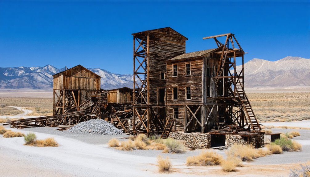
Berlin-Ichthyosaur State Park: Mining History Meets Ancient Fossils
Tucked into the western slope of the Shoshone Mountains at 7,000 feet, Berlin-Ichthyosaur State Park preserves an unlikely pairing: a remarkably intact 1890s mining camp and North America’s richest deposit of giant marine reptile fossils.
You’ll find Berlin’s 30-stamp mill, assay office, and weathered housing just as miners left them when ore values dropped in 1911. The Berlin mining operation yielded 42,000 troy ounces of gold before abandonment.
Walk the cemetery where original residents rest, then shift 225 million years backward to examine *Shonisaurus popularis* remains—37–40 ichthyosaur fossils discovered since geologist Siemon Muller’s 1928 find.
Nevada’s state government purchased the townsite in 1970, practicing arrested-decay preservation rather than reconstruction.
You’re witnessing mining-camp authenticity alongside prehistoric ocean creatures frozen in stone.
Candelaria: Silver Camp Ruins in West-Central Nevada
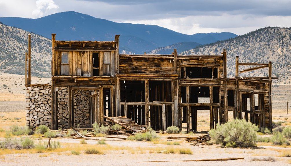
Candelaria’s skeletal remains scatter across the northern slopes of Mt. Diablo, marking where 1,500 fortune-seekers once endured one of Nevada’s harshest environments.
Fifteen hundred desperate souls chased silver dreams across Mt. Diablo’s punishing slopes, leaving only bones and broken stone behind.
You’ll find Candelaria history written in crumbling foundations and toxic dust—this 1864 silver camp produced $15–20 million while claiming countless lives through “miners’ consumption” caused by dry-mill silica.
Mining impact shaped every brutal aspect of life:
- Water sold for $1.00 per gallon before 1880s pipelines
- Twenty-four saloons served a population celebrating weeks without murders
- Dry crushing operations poisoned air, causing fatal respiratory disease
- Northern Belle Mine’s $15 million output came at devastating human cost
Today’s open-pit operations dominate the site, but you’ll still witness remnants of freedom’s darker price—where men gambled health for silver beneath scorching sun and choking dust.
Planning Your Ghost Town Day Trip From Carson City
Your exploration of Nevada’s silver camps requires more than enthusiasm—you’ll need a practical route map that accounts for summer heat, dirt-road closures, and the stark reality that some destinations consume five hours of round-trip driving.
Fort Churchill offers the easiest introduction—forty miles east via US‑50, with museum exhibits and adobe ruins in a maintained state park.
Old Washoe City sits twenty minutes north, perfect for sunrise photography before valley winds kick up.
Pine Grove demands commitment: two hours each way on graded dirt roads that turn impassable after winter storms.
Understanding exploration logistics means checking road conditions, carrying extra water during July’s hundred-degree afternoons, and timing departures to avoid after-dark navigation on unmarked routes.
Ghost town history rewards preparation, not impulse.
Essential Tips for Exploring Nevada’s Backcountry Ghost Towns
Before you leave pavement for Nevada’s ghost town corridors, acknowledge that backcountry exploration carries genuine risk—I’ve watched July heat buckle unprepared visitors, watched winter storms trap confident drivers, and watched cellular bars vanish within twenty minutes of Carson City’s edge.
These safety precautions aren’t negotiable:
- Carry BLM/USGS topo maps and offline GPS; unsigned mining roads don’t appear on vehicle navigation systems
- Pack three days of water, food, and shelter regardless of your planned return time
- Inform trusted contacts of exact routes with predetermined check-in windows
- Bring satellite communicator or PLB for emergency messaging where cell service fails
Master basic navigation tips: use paper maps and compass as backup, track fuel range including detours, and equip high-clearance vehicles with recovery gear you’ve practiced deploying.
Frequently Asked Questions
Are Dogs Allowed at Nevada Ghost Town Sites Near Carson City?
You’ll find most Nevada ghost town sites near Carson City welcome dogs under dog-friendly policies, though leash requirements typically apply. Always verify land status beforehand, carry water, and protect fragile ruins—responsible exploration preserves these treasures for everyone.
Do I Need Special Permits to Visit Ghost Towns Around Carson City?
You won’t need permits for casual BLM ghost-town visits, but permit requirements change on private land—always check visiting guidelines first. I’ve learned respecting boundaries protects these fragile sites while keeping access open for everyone’s exploration.
Which Ghost Towns Near Carson City Offer Camping Facilities?
Fort Churchill State Historic Park offers the best ghost town camping combo—you’ll find a 20-site developed campground plus dispersed Scout Camp spots near the 1860 fort ruins, with camping amenities supporting your ghost town attractions exploration freedom.
Can I Use Metal Detectors at Nevada Ghost Town Sites?
You’ll hit a legal wall: metal detecting regulations ban artifact removal at Nevada ghost towns on public land. Historical preservation concerns trump treasure hunting—disturbing 50+ year-old items risks fines and confiscation of your gear.
What Cell Phone Coverage Exists at Ghost Towns Near Carson City?
Cell service availability drops sharply once you leave Carson City’s core. Coverage limitations are severe at remote ghost towns—expect dead zones in basins and canyons. You’ll want offline maps and emergency prep before heading out.
References
- https://en.wikipedia.org/wiki/List_of_ghost_towns_in_Nevada
- https://nvtami.com/2022/04/01/top-10-ghost-towns-of-nevada-northwest/
- https://travelnevada.com/ghost-town/ghost-towns-near-reno/
- https://www.visittheusa.com/experience/6-nevada-ghost-towns-explore-if-you-dare
- https://lakecity.com/carson-old-carson-ghost-towns/
- https://travelnevada.com/ghost-town/
- https://forgottennevada.org/sites/newlist.html
- https://westernmininghistory.com/towns/nevada/gold-hill/
- https://visitvirginiacitynv.com/history/
- https://www.nvexpeditions.com/storey/goldhill.php


