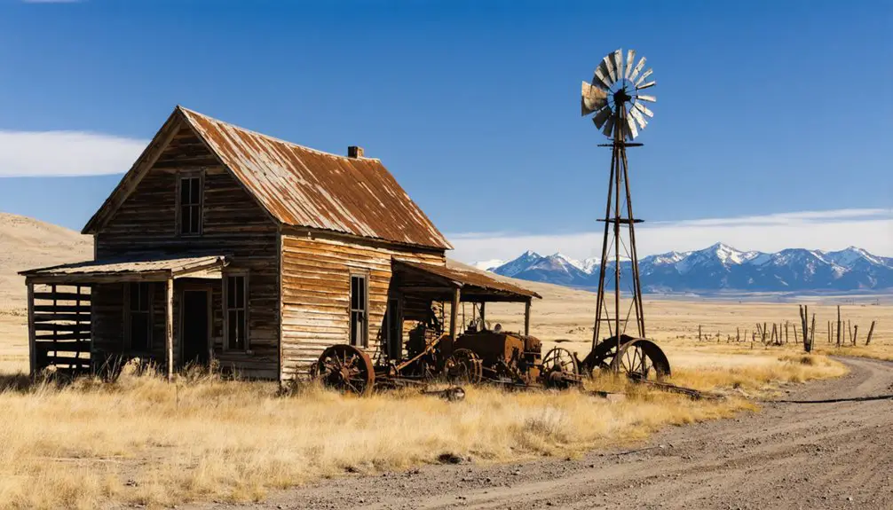
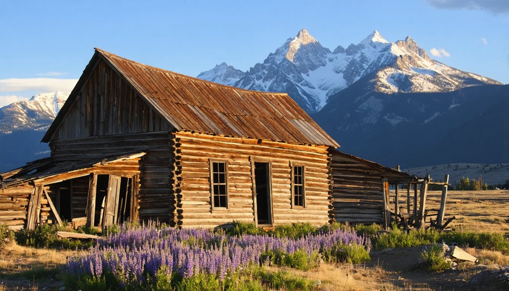
You’ll find Kirwin and Arland, two remarkably preserved ghost towns, in the Absaroka Mountains northeast of Cody. Kirwin, perched above 9,000 feet, once boasted electricity and telephones before a deadly 1907 avalanche drove residents away forever. The violent frontier post of Arland witnessed murders and shootouts throughout the 1880s-90s. Both sites still display weathered log cabins, rusted mining equipment, and artifacts exactly where miners left them. Access requires high-clearance 4×4 vehicles and careful summer planning, though guided tours from Cody handle the challenging terrain while sharing the region’s dark history.
Key Takeaways
- Kirwin and Arland are historic ghost towns near Cody, established in the 1880s during the Absaroka Mountains gold rush era.
- Kirwin sits above 9,000 feet and was abandoned after a deadly 1907 avalanche killed three people and terrified survivors.
- Weathered log cabins, mining offices, and authentic artifacts from the 1890s remain accessible for visitors to explore freely.
- Access requires high-clearance 4×4 vehicles or UTVs, with mid-summer through early September offering the best visiting conditions.
- Guided tours from Cody run May through mid-September, providing historical context and navigating primitive mountain roads safely.
Kirwin: Wyoming’s Best-Preserved Mining Ghost Town
While deer hunting on Spar Mountain in 1885, Harry Adams and Will Kirwin stumbled upon gold and silver deposits in the Wood River Valley that would transform the remote wilderness into one of Wyoming’s most prosperous—and ultimately most mysterious—mining settlements.
You’ll find Kirwin’s history defined by wealthy Eastern investors who built a proper town rather than a ramshackle camp. By 1905, mining techniques had advanced considerably—the Tumlum mine featured a 250-foot shaft with steam-powered hoists, while the Galena Ridge Tunnel penetrated 600 feet into the mountain.
At 9,500 feet elevation, 200 residents enjoyed electricity, telephones, and daily amenities. The power plant, which cost $15,000, provided electricity to buildings throughout the town, while two-story structures like a hotel and clubhouse dominated the skyline. Charles Tewksbury and his wife Sarah operated a store and hotel, providing essential goods and lodging to the community.
Then came 1907’s devastating avalanche. Three died, buildings collapsed, and survivors fled—not from exhausted veins, but superstition and fear that still shrouds the town’s abandonment in mystery.
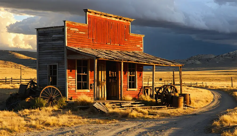
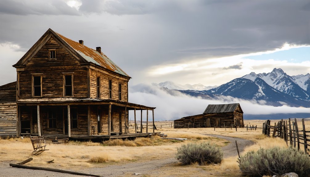
The Bloody Town of Arland: Violence on the Frontier
When French businessman Victor Arland and buffalo hunter John Corbett established their settlement eight miles northwest of Meeteetse in spring 1884, they couldn’t have predicted their frontier trading post would earn infamy as “a bloody place.”
The partners had operated together since 1880, and by October 1884, Arland’s letter documented their impressive facilities—a store, saloon, restaurant, basement storage, stable for 25 horses, oat storage cabin, and chicken house. The settlement also featured a bunk house, residential cabins, and a dance hall. In 1890, Rose Williams opened a brothel that would serve local leaders and outlaws alike.
Arland violence escalated dramatically:
Violence defined the settlement of Arland, where deadly shootouts, revenge killings, and murder marked frontier life in the 1880s and 1890s.
- Jesse Conway shot dead by Belle Drewry during a saloon altercation
- Conway’s associates killed Belle and three women in retaliation the following night
- Founder Victor Arland murdered in Red Lodge, Montana, December 1889
- Belle Drewry poisoned on the road to Arland in 1894
Frontier justice was swift, brutal, and often fatal in this untamed settlement.
Gold Rush History in the Absaroka Mountains
If you’d ventured into the Wood River headwaters in October 1885, you might’ve encountered deer hunters Harry Adams and William Kirwin hauling gold ore samples from Spar Mountain—a discovery that sparked the region’s rush and led to the formal organization of the Wood River Mining District by 1891.
Within three years of that initial find, miners at Henderson Mountain’s Little Daisy and Homestake claims had already extracted 420 tons of rich ore, while prospectors fanned out across what would become the Kirwin, Sunlight, and New World districts.
The consolidation of scattered claims into major operations like Galena Ridge and Shoshone Mountain by 1902-1903 marked the shift from frontier prospecting to industrial-scale mining, though these Absaroka ventures never matched the earlier South Pass-Atlantic City district‘s 300,000-ounce yield. Today, these same Absaroka districts offer recreational prospectors opportunities to pan for placer gold deposits where limited commercial exploration has left undiscovered deposits. The 1872 mining law allowed citizens to locate claims that existed as long as maintenance fees were paid, with patented claims granting private ownership while unpatented claims permitted mining rights on public land only.
Discovery and Early Claims
The great migratory wave of prospectors who’d chased fortune from California’s 1848 strikes through Nevada’s Comstock Lode, Colorado’s 1859 discoveries, and Montana’s booming camps at Bannack and Virginia City eventually turned their attention to Wyoming’s remote Absaroka Mountains in the 1870s.
These experienced miners spotted what others had missed:
- Quartz veins gleaming through volcanic outcrops on Henderson Mountain’s exposed ridges
- Iron-oxide staining marking sulfide zones along Spar Mountain’s weathered faces
- Altered volcanic centers where Eocene intrusions promised hidden ore bodies
- Placer concentrations in high basins fed by gold-bearing lodes above
William Kirwin’s 1880s gold discovery while deer hunting sparked the district bearing his name.
After 1882’s Crow Reservation reduction opened legal access, claim staking exploded—over 1,450 locations flooded the New World District alone. The first prospectors had ventured into these mountains back in 1870, exploring the Lamar River area before an Indian ambush forced their retreat. The earliest mining claims were actually staked on Crow Indian land during the 1860s, predating even these official explorations.
Mining Camps and Infrastructure
As prospectors filed their claims across Henderson and Spar mountains through the 1880s and 1890s, they confronted an infrastructure challenge that would define the district’s entire trajectory: moving tons of heavy machinery up steep trails into country where snow closed passes seven months each year.
You’ll find evidence of their solution in the transportation networks they carved—pack trails from Cody and Meeteetse that carried stamp mills piece by piece, stagecoach routes linking Kirwin to the valley below every other day.
Mining technology arrived on mule back: boilers, steam engines, even smelters hauled to 9,000 feet.
At Kirwin, two stores, a hotel, assay office, and sawmill clustered near the mill works, forming a self-sufficient camp where 200 souls worked ore between spring thaw and first snow.
The primitive Boulder Road served as the main artery for prospectors transporting equipment into Independence, where over 500 men converged during the 1892-1893 peak of the gold rush.
Independence itself sat in the high Absaroka Range, where miners endured harsh conditions to extract precious ores from the mountain’s depths.
Decline and Abandonment Era
The exodus left behind:
- Half-filled whiskey bottles frozen solid on saloon counters
- Ore carts rusting mid-track, their loads still waiting for nonexistent smelters
- Cabin doors swinging open to snowdrifts and packrat nests
- Assay reports scattered across office floors, documenting vanishing yields
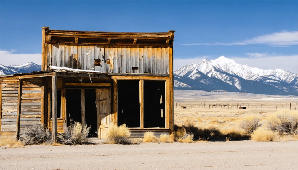
What You’ll Find at Kirwin Today
At over 9,000 feet in the upper Wood River canyon, you’ll encounter weathered log shells and frame skeletons—the roofless hotel, assay shop, general store foundations, and miner cabins scattered where three people died in the 1907 avalanche.
Hand-hewn timbers show frontier notching techniques, while rusted mining hardware and ore-handling debris mark the nearby adits where Shoshone Mining & Development and Galena Ridge Mining companies once extracted gold, silver, and copper.
The isolation is palpable: 12,000-foot peaks loom above open avalanche paths, and the Wood River cuts through a narrow valley where brutal winters drove the final residents out by the 1930s.
Standing Buildings and Artifacts
Weathered cabins and mining offices from the 1890s rise from Kirwin’s meadow like time capsules frozen mid-collapse.
You’ll discover standing structures with concrete chimneys still intact, their frame walls missing doors and windows but defiant against total ruin. These aren’t roped-off museum pieces—you’ll walk through authentic remnants where miners lived and worked.
The mining artifacts scattered throughout tell unfinished stories:
- Rusted tools lying exactly where workers left them over a century ago
- Early electrical appliances and telephone boxes from the “modern” camp era
- Heavy mill machinery components gradually sinking into earth near old adits
- Furniture remnants inside deteriorating cabins—tables, bed frames, and domestic hardware
Since 1999, Forest Service stabilization work has preserved these fragile witnesses to frontier ambition.
Remote Mountain Atmosphere
When you step into Kirwin’s remaining structures, your senses immediately register what archival photographs can’t convey—the dank, musty smell of century-old timber decay mixed with mountain dampness.
Limited natural light filters through weathered boards, casting shadows across rusted tools left exactly where miners abandoned them. The remote wilderness location, 27 miles deep into Shoshone National Forest, demands high-clearance vehicles and multiple river crossings just to reach this isolated pocket of history.
You’ll notice atmospheric conditions shift dramatically inside these century-old buildings. Dark corners harbor unknown inhabitants—possibly wildlife in bear country. Your body responds instinctively; visitors report hair standing on their necks as they navigate the preserved interiors.
The 1907 avalanche’s legacy lingers here, whether through documented tragedy or reported voices echoing through mountain silence.
Planning Your Ghost Town Adventure From Cody
Because most ghost towns near Cody sit at elevations between 7,000 and 9,200 feet along narrow shelf roads that shift from pavement to gravel to primitive track, your adventure begins not with spontaneity but with careful preparation.
Smart trip preparation means embracing the realities of remote mountain access:
- Time your window: Mid-summer through early September offers the most reliable conditions, with snowmelt clearing roads and daylight extending your turn-around options.
- Secure your vehicle: High-clearance 4×4 or outfitted UTV recommended; commercial shuttles from Meeteetse eliminate navigation stress.
- Pack self-sufficiency: Extra fuel, paper maps, bear spray, emergency gear—no cell towers guard these routes.
- Start early: Afternoon thunderstorms build fast in the Absarokas.
These travel tips aren’t restrictions; they’re keys to releasing backcountry freedom safely.
The Eerie Atmosphere and Paranormal Reputation
Your boots hit Kirwin’s weathered boardwalks after miles of switchbacks, fuel canisters rattling in the bed, bear spray tested and holstered—but no preparation accounts for the moment you step through a doorframe at 9,200 feet and feel the air change.
Paranormal investigations documented shadowy figures against sun-bleached walls where miners once bunked. You’ll photograph what looks like faces in window glass, though nobody’s lived here since 1907.
Faces appear in century-old window glass where no living person has stood since the mines went silent.
The Wood River valley traps sounds differently at this elevation—footsteps echo where they shouldn’t, and that weight on your shoulder might be atmospheric pressure or something the researchers can’t explain.
Ghostly encounters cluster in specific structures, not randomly scattered. Freedom means confronting what settlement and abandonment leave behind, whether those presences register on EMF meters or just your gut.
Guided Tours and Visitor Information
How do you reach a ghost town that avalanches erased from maps in 1907? You’ll need guided tours departing Cody around 9:00 a.m., May through mid-September.
Commercial operators provide the essentials:
- 4×4 transport maneuvering primitive roads and multiple river crossings
- Expert guides interpreting mining-boom archives and the 1907 disaster
- Snacks and beverages for the full-day mountain expedition
- Maps to Kirwin, Double Dee Ranch, and Amelia Earhart’s cabin
Meeteetse Museums organizes free interpretive trips several times yearly, emphasizing archaeological context alongside ghost-town exploration.
For visitor information, contact Cody Wyoming Adventures or museum coordinators—they’ll help you traverse the 34-mile Absaroka backcountry route that standard vehicles can’t handle.
Original building remains await in that high-elevation valley, preserved without theme-park overlay.
Frequently Asked Questions
Are Pets Allowed on the Trail to Kirwin Ghost Town?
Pets are generally allowed under Shoshone National Forest pet policies, but you’ll need leashes in developed areas and strict voice control elsewhere. Remember trail etiquette: bear country and creek crossings demand responsible handling throughout this historic route.
Can You Camp Overnight Near Kirwin or Arland Ghost Towns?
You can camp overnight near Kirwin at Brown Mountain Campground’s seven first-come sites, following camping regulations and overnight safety practices. Arland sits on private land, so you’ll need landowner permission before camping there.
What Cell Phone Coverage Exists Along the Route to Kirwin?
You’ll lose cell service once you leave Meeteetse’s town limits. Network reliability becomes nonexistent throughout the National Forest route to Kirwin. Consider packing a satellite communicator—Garmin InReach units offer backup communication when you’re off-grid.
Are There Restroom Facilities Available at Kirwin Ghost Town?
Like an old outpost offering essential shelter, you’ll find a vault toilet near Kirwin’s parking area—basic visitor amenities serving your needs. Historical records and trip reports confirm this restroom location remains functional year-round.
Do I Need a Permit to Visit Kirwin?
You don’t need a permit for day visits—Kirwin’s accessibility as public Forest Service land honors the spirit of open exploration that shaped Kirwin history, letting you walk freely among the weathered cabins and rusting machinery.
References
- https://travelwyoming.com/blog/stories/post/5-wyoming-ghost-towns-you-need-to-explore/
- https://www.codywyomingnet.com/meeteetse_wyoming/ghost_towns.php
- https://mycountry955.com/would-you-stay-in-any-of-wyomings-great-ghost-towns/
- https://klewtv.com/news/local/orbitz-unveils-top-ten-ghost-towns-to-visit
- https://www.canyonrealestate.net/wyoming-real-estate-blog/discovering-hidden-gems-in-cody-wyoming
- https://www.youtube.com/watch?v=Oe33S_KII3k
- https://www.tripadvisor.com/Attraction_Review-g60519-d8454008-Reviews-Kirwin_Ghost_Town-Meeteetse_Wyoming.html
- https://www.meeteetsewy.com/places-to-visit/kirwin-ghost-town-wyoming
- https://www.codyyellowstone.org/activities/kirwin-ghost-town-adventures/
- https://cowboystatedaily.com/2024/10/20/haunted-wyoming-kirwin-is-a-ghost-town-haunted-by-real-spirits/