You’ll discover over two dozen ghost towns within an hour of Columbus, ranging from completely vanished communities like the original Alum Creek railroad depot to partially preserved sites like Renner, where St. Paul United Church of Christ still stands among the cornfields. Most exist only as weathered cemeteries, isolated foundations, and names on 19th-century county atlases that modern GPS won’t recognize. Transportation revolutions—from canals to railroads to highways—created and destroyed these settlements, leaving behind traces that require historic maps, satellite imagery, and seasonal timing to properly explore.
Key Takeaways
- Alum Creek Railroad Junction was a critical rail nexus since 1879, now erased by urban development and preserved only in archival maps.
- Renner features St. Paul United Church of Christ and a cemetery with late nineteenth-century gravestones from Welsh settlers who arrived between 1825-1835.
- Moonville emerged in the mid-1850s as a coal-mining settlement, with the brick-lined Moonville Tunnel remaining as a historical structure from that era.
- Boston Mills, founded in 1806, became a ghost town after 1974 federal buyouts and is now associated with “Helltown legends.”
- Most ghost towns near Columbus resulted from transportation changes, highway construction, and suburban sprawl erasing original depot stops and canal landings.
What Defines a Ghost Town in Central Ohio
When you drive past an overgrown cemetery flanked by crumbling foundation stones along a Central Ohio back road, you’re likely standing in what researchers classify as a ghost town—a once-thriving community that suffered near-total depopulation and economic collapse.
Unlike fully erased sites, these locations retain substantial visible remains: building ruins, road grids, bridge abutments, or burial grounds that mark former settlement boundaries.
Ghost town characteristics in Ohio typically include loss of key services, cessation of town-based economic activity, and conversion of land to agricultural or park use.
Economic decline stemmed from transportation changes—railroad realignments, canal abandonment—or loss of local mills and industry. Some settlements disappeared due to flood control projects, as seen when Atwood in Carroll County was abandoned to create Atwood Lake for water management purposes.
These ghost towns serve as historical snapshots that reveal how Central Ohio communities evolved and declined over time. Many persist only as property-record place names, documented through historic maps, gazetteers, and county archives that verify their existence as distinct platted communities.
Alum Creek and the Lost Railroad Communities of Franklin County
The railroad corridor along Alum Creek exemplifies how Franklin County’s ghost towns emerged and vanished within a single century.
You’ll find Alum Creek listed among historical communities that served as depot stops for surrounding farmsteads, shipping grain and raw materials into Columbus markets. The railroad significance peaked when 11,295 county residents worked directly for rail companies by 1930, sustaining small hamlets with warehouses, general stores, and sidings.
By 1930, over eleven thousand Franklin County workers depended on railroads that kept depot towns like Alum Creek alive with commerce.
But highway freight and suburban sprawl triggered economic decline throughout these micro-villages. When passenger services ended and trucking dominated, places like Alum Creek lost their purpose.
Today, archival maps preserve the name, but you won’t discover any depot, grain elevator, or town square—just farmland and subdivision streets where trains once stopped.
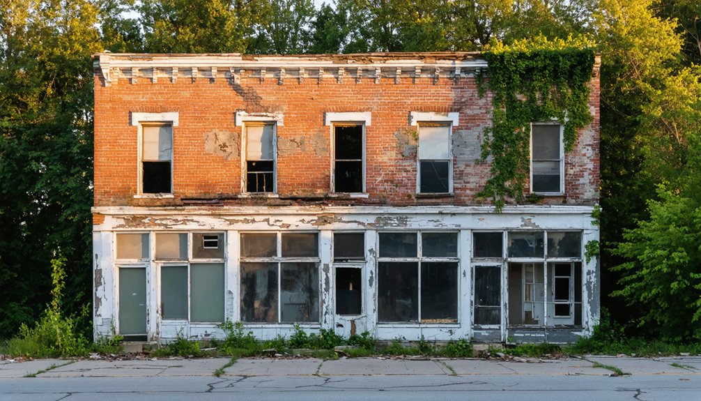
Vanished Villages Within Modern Columbus Boundaries
You’ll find the ghost towns nearest to Columbus not in distant cornfields but beneath your own streets—entire communities erased by annexation, highway construction, and urban renewal between the 1940s and 1970s.
If you trace Eastwood’s surviving street names or stand where Alum Creek’s railroad junction once thrived, you’re walking through palimpsests: neighborhoods whose original residents, commercial strips, and street grids vanished even as the city limits expanded to absorb them.
These aren’t rural ghost towns with weathered barns—they’re urban ghosts, invisible except in old plat maps, aerial photographs, and the fragmented memories of displaced families. Machine learning now extracts building footprints and construction details from Sanborn Fire Insurance maps, reconstructing what highway projects like I-70 and I-71 obliterated from historically Black neighborhoods. Flytown’s rapidly built wooden homes for factory workers disappeared entirely when I-670 carved through the northwest side, scattering Irish, Welsh, German, and later Italian families who had made the working-class neighborhood their own.
Alum Creek Railroad Junction
Buried beneath the asphalt and industrial sprawl near John Glenn Columbus International Airport lies the memory of Alum Creek Railroad Junction, a vanished crossroads that once channeled coal trains and commerce into Ohio’s capital.
You’ll find no trace today of this crucial 1879 nexus where the Columbus & Sunday Creek Valley coal line met the Pittsburgh, Cincinnati & St. Louis tracks.
Later rechristened East Columbus, the junction served Ralston Steel Car Company‘s sprawling works from 1905 to 1953, its sidings humming with freight cars rolling toward Union Station.
Railroad history records show the 1886–1887 expansion through Rarig’s and Shepard solidified the route’s importance.
The Alum Creek area itself holds deeper historical significance—it was home to a Quaker settlement established in 1809 by Cyrus Benedict and his family, who would later play crucial roles in the Underground Railroad operations that moved fugitive slaves northward to freedom.
By 1930, Columbus had become a major rail hub with 164 daily trains passing through the city, illustrating the critical role junctions like Alum Creek played in connecting the capital to the broader network.
Now only archival maps preserve Alum Creek Junction’s name—another railroad town erased by progress, its bones scattered beneath runways and warehouses.
Eastwood’s Surviving Street Names
While railroad junctions vanished under concrete, entire villages within Columbus’s current boundaries disappeared into residential grids, leaving behind only street names as cryptic markers.
You’ll find Eastwood’s clearest trace along Eastwood Avenue near Woodland Avenue, where unusually narrow pavement reveals mid-1800s rural road dimensions. The 1856 Franklin County map documents Eastwood history as a Montgomery Township hamlet centered on East Main Street between James and Beechwood Roads, complete with school and Congregational church.
By the 1870s, annexation erased its civic identity. P.V.N. Myers’ Eastwood Addition platted around 1874–1878 commercialized the name for urban lots.
Today, ghost-town surveys list Eastwood among Franklin County’s vanished communities—no surviving landmarks remain except that single street, preserving forgotten autonomy beneath your wheels. Similarly, Seagrove in southern Franklin County exists only as a name on street signs and old records, having been gradually absorbed into Columbus after originating as a small railroad community in the late 1800s.
Urban Annexation Erased Communities
Between 1950 and the early 1970s, Columbus swallowed more than 170 square miles of surrounding territory—an annexation spree that erased entire communities from the map with surgical efficiency.
Mayor Jack Sensenbrenner’s water-for-annexation policy left you no choice: join Columbus or go thirsty. Clinton Township split into noncontiguous islands. Franklin Township lost its heart. Hundreds of crossroads settlements and platted villages vanished into the municipal grid, their names surviving only on cemetery gates and fading plat maps.
This urban transformation wasn’t conquest—it was bureaucratic erasure. Your grandparents’ village became just another Columbus neighborhood, its community identity stripped away with a single ordinance. The annexation wave increased Columbus from a compact 35 square miles to nearly 50 square miles by the 1980s, fundamentally reshaping the region’s municipal landscape.
The city’s explosive growth masked a darker truth: whole townships ceased to exist, their autonomy traded for running water.
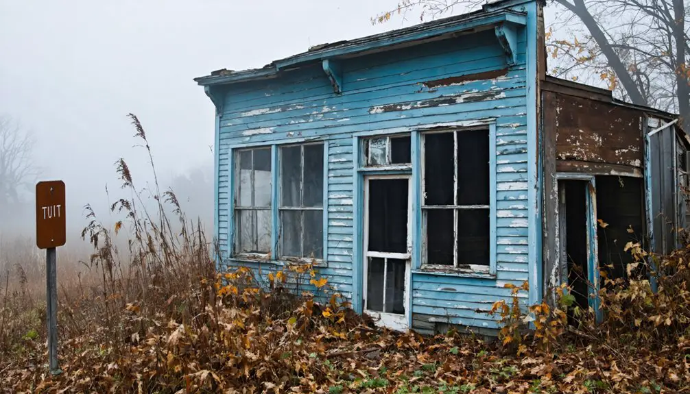
Renner: A Surviving Church Among the Cornfields
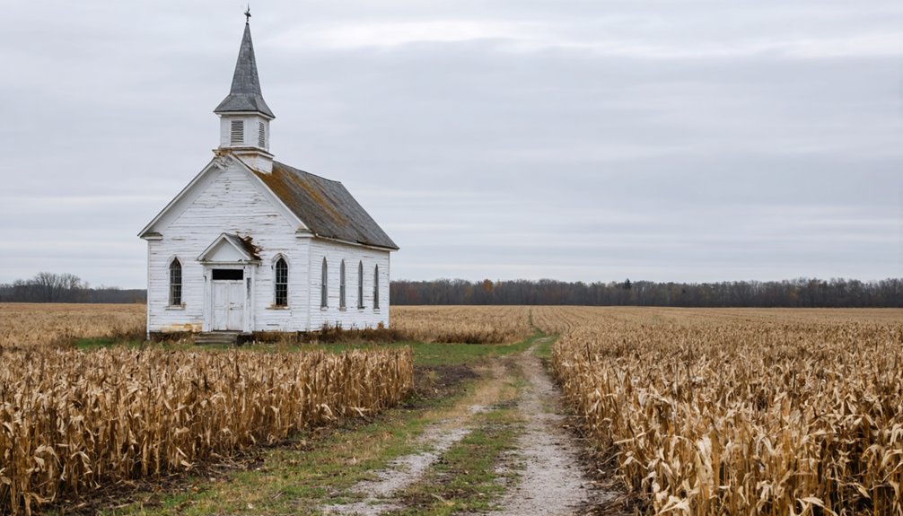
You’ll find Renner’s story preserved not in busy street corners, but in a white country church standing sentinel over cornfields along County Highway 41 in Tuscarawas County.
St. Paul United Church of Christ and its weathered cemetery mark what was once a rural crossroads community substantial enough to warrant its own post office from 1892 to 1901, before the settlement dispersed back into farmland.
The church’s continued Sunday services and the German-ancestry gravestones behind it offer tangible evidence of families who carved out this Norwich Township hamlet in the late nineteenth century, their names and dates still legible in the stone records.
Norwich Township Rural Crossroads
Among the scattered rural crossroads that emerged throughout Norwich Township’s interior, Renner stands as perhaps the most enduring symbol to the Welsh settlement wave that swept through the area between 1825 and 1835.
You’ll find this community where families carved homesteads from densely forested land using the girdling method—cutting deep rings around tree trunks to kill foliage and let sunlight reach the ground below.
While Grove City contained approximately thirty families and two stores by 1858, rural settlements like Renner remained agricultural outposts where Welsh immigrants raised corn, wheat, and flax on fertile soil.
The construction of the Harrisburg Pike and Franklin Pike connected these isolated crossroads to larger markets, though Renner’s church remains the primary evidence to this vanished community’s Welsh heritage.
Saint James Lutheran Legacy
The white-painted steeple of St. James Lutheran Church still rises above Franklin County cornfields, marking where German farm families gathered in the 1840s.
You’ll find Johann Georg Renner’s 1882 grave among family plots that trace generations who refused to abandon their rural identity. While crossroads settlements vanished, this congregation persisted—its cemetery recording births, marriages, and deaths in German script long after English dominated Columbus suburbs creeping outward.
The churchyard became historical preservation by accident: families simply kept returning. Services shifted from German to English, but the building remained, surrounded by farmland that developers eyed hungrily.
Today it stands as living contradiction—not quite ghost town, not quite suburb—where Sunday worship continues amid landscapes that swallowed neighboring communities whole.
Cemetery Traces and Roads
Renner Road still cuts through Franklin County farmland exactly where Johann Renner’s descendants intended when they settled 230 acres in the 1840s.
You’ll find Saint James Lutheran Cemetery at the intersection with Hilliard Rome Road, where foundation stones from the original log church mark the northwest corner. The headstones tell their own story—German inscriptions documenting Johann (1802–1882) and Anna Renner (1804–1878) alongside neighboring pioneers who worshipped in their native tongue until the 1890s.
Cemetery preservation here means more than maintaining graves. It’s safeguarding rural heritage that governmental entities often overlook.
These weathered markers and country roads represent infrastructure the Renner community built without permission—establishing schools, churches, and agricultural networks that thrived for generations before quietly dissolving into cornfields.
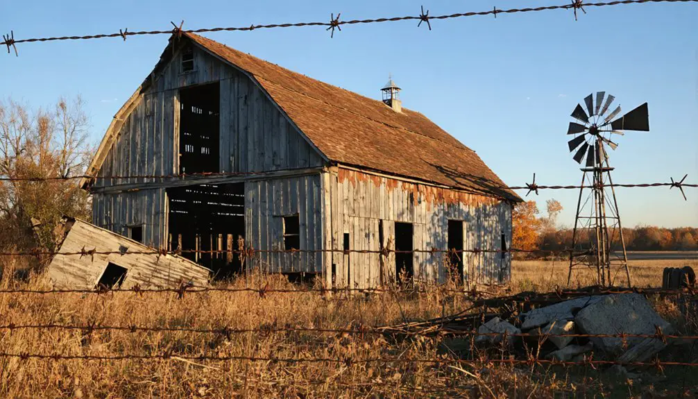
Moonville Tunnel and the Coal Towns of Vinton County
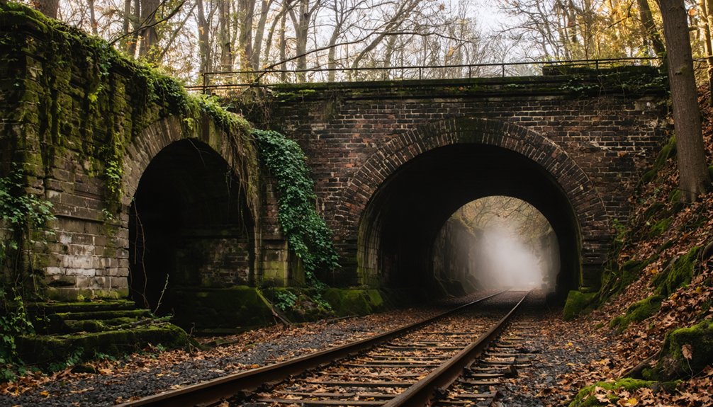
Deep in Vinton County’s forested hills, Moonville emerged in the mid-1850s as a coal-mining and railroad settlement that would anchor a network of isolated resource camps.
You’ll find its Moonville history rooted in Samuel Coe’s 1856 land grant to the Marietta & Cincinnati Railroad, which shortened the Marietta–Cincinnati route and revealed rich coal seams and clay deposits.
At its 1870s–1880s peak, roughly 100 residents mined coal, worked the rails, and farmed scattered hollows.
At its height in the 1870s and 1880s, Moonville supported a community of approximately 100 coal miners, railroad workers, and farmers.
Coal mining fed nearby Hope Furnace and sustained grist mills along Raccoon Creek.
The brick-lined Moonville Tunnel—still standing—enabled freight trains to pierce otherwise impassable terrain.
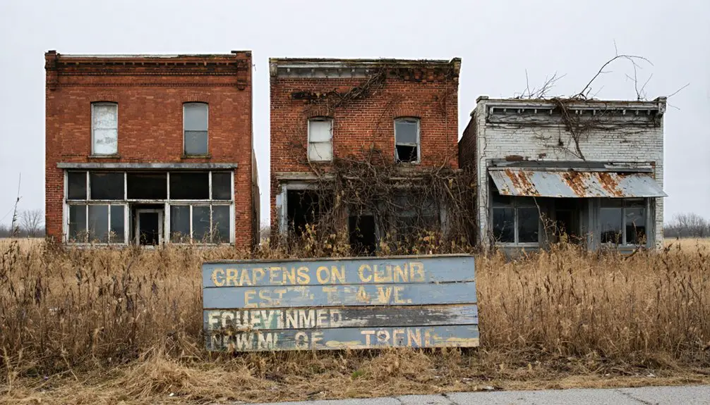
Boston Mills and the Birth of “Helltown” Folklore
Founded in 1806 along the Cuyahoga River, Boston Mills grew as Summit County’s oldest village through a succession of industrial ventures—grist mills in the 1820s, a paper mill soon after, and canal-side commerce when the Ohio & Erie Canal arrived in the 1830s.
When the National Park Service created Cuyahoga Valley National Recreation Area in 1974, federal buyouts forced residents from hundreds of properties at contested prices.
Boarded homes lined the streets, some burned for fire training, transforming the landscape into a visible ghost town.
By the late 1970s, these abandoned structures fed “Helltown legends”—tales of Satanic cults in the old church, mutants hiding near closed roads, and massacres on a derelict school bus.
You’ll find most buildings demolished by 2016, yet folklore persists where freedom met forced displacement.
How Transportation Shaped and Destroyed Small Settlements
Across central Ohio, the arrival of a railroad depot could transform a crossroads hamlet into a thriving village overnight, while the decision to route tracks two miles away condemned equally promising settlements to slow erasure.
Transportation impacts dictated which communities survived and which vanished. You’ll find census records showing canal towns like Lockbourne prospering in the 1840s, then withering once rails bypassed their wharves.
Transportation revolutions determined survival: census records document canal towns flourishing in the 1840s before rails redirected commerce elsewhere.
Settlement patterns shifted violently again when Interstate 70 carved through Columbus in the 1960s, demolishing Hanford Village and fragmenting working-class neighborhoods into isolated pockets.
County plat maps reveal ghost-town footprints—former station stops, abandoned canal landings, highway-severed blocks—where commerce once flourished.
Each transportation revolution rewrote the landscape, leaving you surveying foundations where freedom-seeking families built homes that infrastructure planners erased.
Finding Traces: Cemeteries, Street Names, and Hidden Foundations
When you walk through downtown Columbus’s North Market today, you’re treading on one of the city’s darkest cartographic secrets: beneath the vendor stalls and brick pavers lie thousands of frontier-era burials from North Graveyard, established in 1813 to serve soldiers, settlers, and the city’s earliest families.
Partial relocation in the late 1800s left countless bodies behind—38 sets of remains surfaced during 2001 sewer work, more during 2022 construction. This urban archaeology reveals hidden histories across Franklin County, where family plots now stand isolated in Metro Parks, their worn fieldstones obscured by forest growth.
Cemetery records at sites like Renner’s Saint James Lutheran or Borror’s Corners’ Scioto Cemetery often provide the only proof these communities existed, while street names—Renner Road, Briggsdale, Alum Creek—serve as cartographic fossils of erased settlements.
Planning Your Ghost Town Exploration From Columbus
Before you load the car and set your GPS for a weekend of ruin-hunting, understand that successful ghost town exploration from Columbus demands a different kind of trip planning than your typical state park visit.
Ghost town geography rarely appears on modern basemaps—you’ll need 19th-century county atlases and Sanborn fire insurance maps layered over satellite imagery to spot vanished street grids and mill foundations.
Seasonal exploration matters: spring and fall give you clear sightlines to foundations and culverts, while winter reveals old roadbeds but brings ice and early darkness on unplowed township roads.
Download offline maps before heading into southeast Ohio’s cell-dead hollows.
Check land ownership through county GIS portals—most sites sit on private farms or posted industrial land, limiting you to public rights-of-way and cemeteries.
Frequently Asked Questions
Are Any Ghost Towns Near Columbus Rumored to Be Haunted?
Yes—Moonville Tunnel’s phantom lantern still swings along abandoned tracks where workers died. You’ll find haunted history woven through these ruins: ghost sightings at Haydenville’s crumbling company buildings and Moonville consistently rank among Ohio’s most actively investigated paranormal sites.
Which Ghost Town Sites Allow Metal Detecting or Artifact Collecting?
No documented sites permit metal detecting or artifact collecting without permission. You’ll need to contact individual property owners and review Ohio’s metal detecting regulations and artifact collecting guidelines before pursuing any collection activities at these locations.
Can You Camp Overnight Near Moonville Tunnel or Vinton Furnace?
You can’t camp directly at Moonville Tunnel, but you’ll find freedom at nearby Zaleski State Forest’s designated sites or Lake Hope State Park. Follow camping regulations and prioritize night safety in these remote areas.
What Photography Permits Are Needed for Ghost Town Locations?
You’ll need written landowner permission for private ghost town sites—trespassing remains illegal regardless of intent. Public locations trigger permit processes when your photography becomes commercial, uses professional crews, or involves models, following standard photography regulations across Ohio parks.
Were Any Ghost Towns Near Columbus Featured in Films or Television?
No Columbus-area ghost towns have served as film locations or television features. Moonville Tunnel, roughly 75 miles southeast, dominates Ohio’s paranormal productions, while Columbus’s “ghost neighborhoods” appear only in academic documentaries about urban renewal.
References
- https://ohioghosttowns.org/top-10-ghost-towns/
- https://ohioghosttowns.org/franklin-county/
- https://www.youtube.com/watch?v=QWTtG6njIDs
- https://ohio.org/travel-inspiration/articles/haunted-ohio-must-visit-places
- https://u.osu.edu/miller.81/2023/11/17/ghost-neighborhoods-of-columbus-updates/
- https://ohiohome.org/news/blog/october-2022/ghosttowns.aspx
- https://allcolumbusdata.com/tag/ohio-ghost-towns/
- https://en.wikipedia.org/wiki/List_of_ghost_towns_in_Ohio
- https://kids.kiddle.co/List_of_ghost_towns_in_Ohio
- https://www.ohiotraveler.com/moonville-its-a-ghost-town/