You’ll find Ferguson, a submerged lumber town 30 miles southeast of Congaree National Park beneath Lake Marion’s surface. This settlement housed 2,500 workers for the Santee River Cypress Lumber Company from 1890 to 1917, operating as headquarters for a 165,000-acre logging empire that nearly destroyed the ancient cypress forests now protected within Congaree. The 1941 Santee-Cooper hydroelectric project drowned Ferguson’s mill foundations, Church Island’s 1849 Episcopal church, and nearly 9,000 graves. Dive sites and drought cycles reveal what industrial development submerged.
Key Takeaways
- Ferguson, a submerged lumber mill town beneath Lake Marion, was established in the 1890s for cypress logging operations.
- The town housed 2,500 residents at its peak before being submerged by the Santee Cooper project in the early 1940s.
- Church Island, home to the 1849 Church of the Epiphany, was drowned in 1941 during Lake Marion’s creation.
- Ferguson’s submerged remnants include mill foundations, kilns, and artifacts accessible to divers during low water levels.
- The Santee Cooper project displaced hundreds of families and submerged nearly 9,000 graves between 1939 and 1942.
Ferguson: The Submerged Lumber Mill Town Under Lake Marion
Beneath Lake Marion‘s placid surface, approximately 30 miles southeast of Congaree National Park, lie the waterlogged remnants of Ferguson—a purpose-built lumber mill town that once occupied the Santee River floodplain in present-day Orangeburg County.
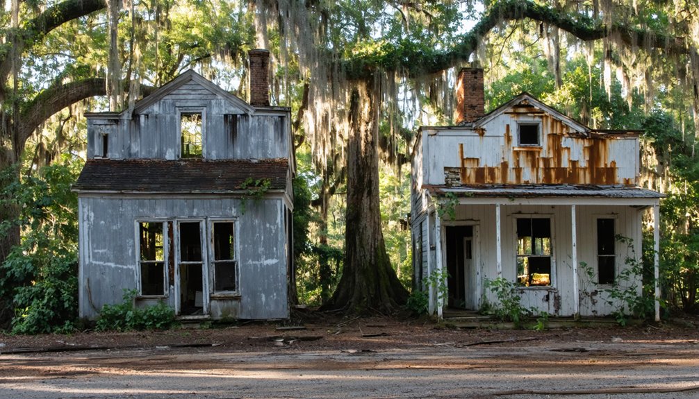
Ferguson history traces to the late 19th century, when Chicago lumber magnate Benjamin Franklin Ferguson financed a cypress milling operation here. The company town housed hundreds of workers, operated its own hospital to combat malaria, and maintained postal service from roughly 1890 to 1917. At its height, Ferguson’s population peaked at about 2,500, remarkable for rural South Carolina at the time.
After the mill closed around 1915, abandonment was swift. The Santee Cooper hydroelectric project sealed Ferguson’s fate: dam construction beginning in 1939 created Lake Marion, and rising waters submerged the town site by the early 1940s. Francis Beidler, who had purchased the land with Ferguson, named the town after his deceased partner when the mill opened in 1910.
Today, submerged structures—mill foundations, kilns, and scattered artifacts—remain accessible to divers exploring South Carolina’s drowned industrial past.
The Santee River Cypress Lumber Company and Its 165,000-Acre Empire
While Ferguson represented a single mill town in the SRCLC network, the parent corporation—the Santee River Cypress Lumber Company—operated on a scale that dwarfed individual settlements.
Founded in 1881, SRCLC controlled over 165,000 acres stretching 75 miles along the Congaree, Wateree, and Santee river systems. You’re looking at one of the Southeast’s largest cypress empires, targeting virgin swamps with trees 500–700 years old.
Their logging techniques relied on seasonal camps, mule teams, and river transport rather than fixed railroads. Operations ran from 1899 to 1915 across the Congaree floodplain, leaving cut stumps visible today.
The ecological consequences were profound, yet difficult swamp conditions forced partial withdrawal, inadvertently preserving tracts that became Congaree National Park. The company’s primary mill near Eutaw Springs employed 400 people and included facilities like bunk houses, a commissary, and a hospital to support the extensive operation. The corporation was formed by businessmen Francis Beidler and Benjamin Ferguson, who established their lumber empire in South Carolina’s Congaree-Wateree-Santee Basin.
Drowned Communities: What Lies Beneath Lake Marion’s Waters
When Lake Marion’s waters rose in the early 1940s, they erased Ferguson’s mill town infrastructure and transformed Church Island’s sacred ground into a contested archaeological site.
The brick kiln and building foundations you’ll find protruding near the island mark Ferguson’s industrial core, while the Church of the Epiphany stood briefly as a waterline monument before vandalism forced its demolition.
Drought cycles expose the spatial relationship between these two sites—Ferguson’s commercial zone lying northwest of the church remnants—revealing how the Santee Cooper project obliterated a complete settlement geography within a single reservoir basin.
The town had been named after Benjamin Franklin Ferguson, a partner who died before the settlement’s establishment over a century ago.
Beneath the reservoir waters lie nearly 9,000 graves, the majority belonging to enslaved Africans and their descendants whose final resting places were either relocated or left to be flooded as the lake filled.
Ferguson Mill Town History
The murky depths of Lake Marion conceal Ferguson, a once-thriving industrial settlement that rose from South Carolina’s Santee River swamps in the 1890s and vanished beneath reservoir waters by 1941.
Chicago lumbermen Francis Beidler and Benjamin Franklin Ferguson established this mill town as headquarters for their Santee River Cypress Lumber Company, acquiring nearly 200,000 acres of cypress floodplain.
The Ferguson legacy includes pioneering infrastructure rarely found in remote settlements:
- Company scrip system that bound 350 workers and their families to company stores
- Indoor plumbing and gas street lighting predating most South Carolina towns
- Hospital, school, and church complex carved from malarial swampland
Mill operations peaked before 1915, transforming ancient cypress into lumber shipped via dedicated rail lines.
The workforce divided along racial lines, with 200-250 black workers and 100-150 white workers maintaining the mill’s operations through the sweltering swamp conditions.
Today’s submerged ruins connect Congaree National Park’s conservation mission to industrial extraction history.
Church Island and Epiphany
Ferguson’s submergence beneath Lake Marion in 1941 marked only the beginning of the Santee-Cooper Project‘s transformation of South Carolina’s river landscape.
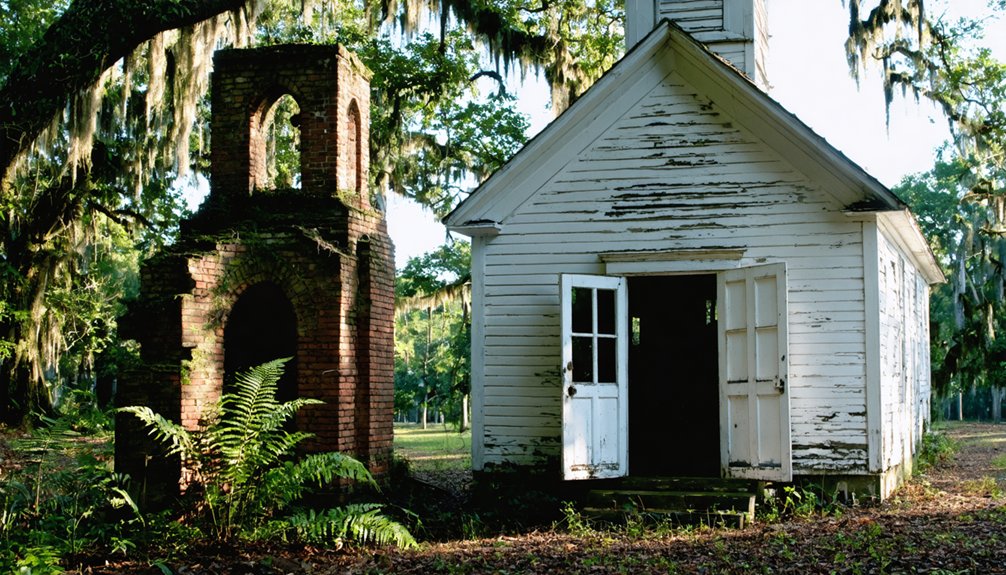
Church Island emerged as the lake’s most haunting artifact—a former hill turned island when waters drowned the 1927 brick Episcopal church known as “The Rocks Church.”
You’ll find only a memorial marker today; the original structure stood until 1957, when vandalism forced its demolition. This Episcopal heritage site served plantation families and river communities before deconsecration and relocation to Eutawville.
Beneath the surface, submerged roads, foundations, and possibly unmarked graves testify to lives uprooted by engineered flooding.
The island represents freedom lost—communities sacrificed for hydroelectric progress, their landscapes permanently erased beneath South Carolina’s largest lake. Today’s visitors discover a unique blend of history preserved in weathered gravestones and memorial stones that mark this sacred ground.
The old Rocks Cemetery features ornate gravestones and several signature stones, with recent maintenance indicating ongoing care and preservation by the local community.
From Logging Wasteland to Protected Wilderness: The Beidler Legacy
When you examine the 15,000-acre Beidler Tract across the Congaree floodplain, you’re looking at a landscape that shifted from extractive industry to preservation between 1899 and 1976.
The Santee River Lumber Company’s 15-year cypress harvest ended not from environmental ethics but from logistical constraints—transporting massive old-growth timber from inland swamps proved economically unsustainable. Many cypress logs were too heavy to float and left behind in the swamp.
What the Beidler family couldn’t profitably log became, by the 1960s, the Southeast’s last remaining river bottom hardwood wilderness, valued at over $30 million in federal acquisition costs.
Santee Cypress Company Operations
During the 1880s, Francis Beidler and B.F. Ferguson incorporated the Santee River Cypress Lumber Company, eventually controlling over 150,000 acres across South Carolina’s river swamps.
You’ll find their operations centered at Ferguson—a mill town on the Santee River near Eutaw Springs—where workers processed ancient bald cypress into construction lumber.
The company’s logging techniques relied on water transport rather than permanent railroads, using these methods:
- Girdling trees to kill and dry them before felling, making transport easier
- Floating logs through natural sloughs and river channels toward the Ferguson mill
- Seasonal camps scattered across floodplains, avoiding costly permanent infrastructure
The Beidler Family Transition
After logging ceased in 1914–1915, Francis Beidler’s decision to retain rather than liquidate his Congaree holdings transformed economic failure into unintentional conservation.
You’ll find that his timber-reserve strategy—betting on future stumpage values—prevented the agricultural drainage and subdivision that gutted other Southern floodplains.
When Beidler died in 1924, roughly 15,000 acres passed to his heirs, who maintained title for decades while over 10,000 acres of old-growth remained untouched in the swamp’s inaccessible core.
By the 1960s, foresters labeled these “overmature” stands underutilized capital, triggering renewed harvest of 2,500 acres.
Logging conflicts between Beidler heirs and emerging conservationists ultimately forced federal intervention, converting private hunting preserves and industrial remnants into Congaree Swamp National Monument by 1976—your access to wilderness born from corporate miscalculation.
Conservation From Corporate Holdings
Though cypress logging had devastated Southern swamps from Virginia to Louisiana by 1920, the Congaree’s core survived because Francis Beidler couldn’t extract it profitably.
What started as commercial failure became unintentional corporate conservation. His descendants held 22,000 acres for decades without intervention—neither developing nor destroying the land. This passive stewardship preserved old-growth forest that industry elsewhere had erased.
By 1969, rising timber prices threatened this accidental sanctuary. The Beidler heirs faced pressure to liquidate “overmature” stands, triggering grassroots resistance:
- Conservationists mobilized Friends of Congaree Swamp and Sierra Club chapters
- Senator Fritz Hollings championed federal land preservation legislation
- Congressional designation in 1976 protected 15,000 acres from commercial extraction
Corporate restraint, economic unprofitability, and citizen activism converged to establish permanent protection where market forces had failed.
Church of the Epiphany and Other Lost Landmarks on Lake Marion
Lake Marion’s inundation in the early 1940s transformed high ground above the Santee swamps into isolated islands, preserving—and paradoxically endangering—antebellum religious sites that had served plantation families for nearly a century.
Floodwaters preserved what they destroyed—marooning sacred ground on islands where plantation congregations once gathered in worship.
You’ll find Church Island anchors this ghost-town landscape, where the 1849 Church of the Epiphany once stood alongside Rock’s Church (St. James Santee). The vestry deeded the property to the South Carolina Public Service Authority in May 1941; the final service occurred May 17, 1942.
Deconsecration followed as worship relocated to mainland Eutawville. Vandalism plagued the abandoned structure throughout the 1950s, prompting demolition in 1957.
Today only ornate planter-family headstones and a brick island memorial survive, testifying to an Epiphany legacy drowned by reservoir waters yet accessible to boaters seeking archival evidence of Santee River society.
Displacement and Memory: The Human Cost of the Santee-Cooper Project
When the Santee-Cooper Power and Navigation Project reshaped 180,000 acres of lowcountry landscape between 1939 and 1942, it displaced hundreds of families whose names rarely appear in official project histories.
The displacement impact fell hardest on African American tenant farmers and sharecroppers whose land claims lacked formal documentation, limiting compensation and resettlement options.
Memory preservation challenges include:
- Archival records privileging elite plantation histories while marginalizing accounts of Black agricultural communities and working-class families
- Former river towns—their churches, schools, and commercial centers—permanently submerged beneath Lake Marion and Lake Moultrie
- Economic power structures that excluded displaced populations from lakeside development opportunities and post-project planning processes
You’ll find these submerged landscapes represent more than infrastructure progress—they’re monuments to communities whose autonomy vanished beneath engineered waters.
How to Explore Ghost Town History Near Congaree Today
If you’re ready to trace the region’s submerged histories, Congaree National Park and its surroundings offer multiple entry points into the ghost-town narrative that connects old-growth swamps to drowned mill communities.
Exploring abandoned sites near Crater Lake can provide intriguing insights into the area’s rich history and the impact of human activity on the landscape. As you wander through the remnants, you’ll encounter stories of resilience and change that shaped the communities that once thrived in this breathtaking region. Each site may reveal artifacts and structures that connect visitors to a time when nature and industry intersected in unexpected ways.
Start at the park’s visitor center, where land-transfer records and timber-company exhibits ground Ferguson’s story in archival evidence. Walk boardwalk trails through the same cypress-tupelo ecosystem that surrounded 1890s mill operations, noting logging scars and turpentine remnants.
Ferguson’s timber legacy lives in scarred cypress trunks and turpentine traces—archival fragments embedded in the swamp itself.
Drive east toward Lake Marion, stopping at rural cemeteries and historic markers that anchor ghost stories in spatial coordinates. Launch from Rimini or Eutawville boat ramps to search for Ferguson’s submerged brick kiln at low water.
Pair field visits with county archives and historical-preservation societies to map displacement patterns, transforming drowned landscapes into documented heritage.
Frequently Asked Questions
What Happened to the Native Congaree People Who Originally Inhabited the Region?
The Congaree people you’d find here suffered cultural displacement through disease, enslavement, and war. Their historical legacy survives only through integration with the Catawba Nation, where they merged by 1743, ending independent tribal existence.
Can You Dive or Kayak Over the Submerged Ferguson Mill Ruins?
You’ll find absolutely endless kayaking opportunities over Ferguson’s ruins, but submerged exploration demands careful navigation—machinery lies treacherously beneath the surface. Launch from Ferguson Landing Way, though lower water levels historically revealed safer access to foundation stones.
Were Any Bodies Relocated Before Lake Marion Flooded the Cemeteries?
Yes, you’ll find historical records show about 6,000 graves underwent cemetery relocations before Lake Marion’s flooding, though at least 3,000 Black graves were intentionally left submerged despite documented locations.
How Much Cypress Timber Still Lies Submerged in Lake Marion Today?
No quantified measurements exist documenting submerged cypress timber volumes in Lake Marion. You’ll find cypress conservation complicated by flooded ecosystems containing unmapped virgin-growth forests beneath 100,000 acres, where archival records from 1881-1915 operations remain incomplete today.
Are There Haunted Legends Associated With the Drowned Towns Under Lake Marion?
No documented haunted history exists for Lake Marion’s drowned towns in archival records. While you’ll find “ghostly” atmosphere descriptions of Ferguson’s ruins, verified reports of ghostly sightings or paranormal legends remain absent from historical sources.
References
- https://usghostadventures.com/haunted-stories/haunted-swamp/
- https://www.randomconnections.com/the-ghost-towns-of-lake-marion-part-2-ferguson/
- https://www.youtube.com/watch?v=KQOA3Q1z0Nc
- https://www.randomconnections.com/the-ghost-towns-of-lake-marion/
- https://sc.edu/uofsc/posts/2020/05/memories_of_a_drowned_town.php
- https://en.wikipedia.org/wiki/Ferguson
- http://www.onlyinyourstate.com/south-carolina/abandoned-places-in-sc
- https://www.twocraftycats.com/post/ferguson-an-underwater-ghost-town
- https://crimeandcask.com/city-of-ferguson-submerged-lake-marion/
- https://friendsofcongaree.org/journals/essay-congarees-cypress-story/


