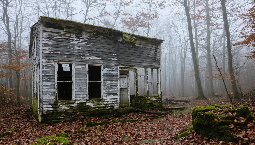
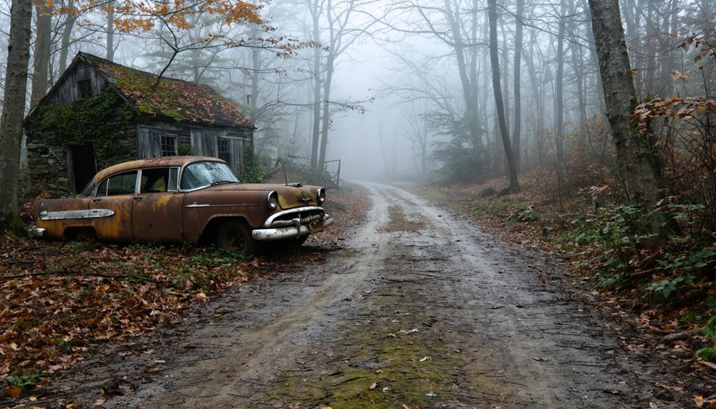
You’ll find several ghost towns within Cuyahoga Valley National Park, most significantly Helltown (Boston Mills), where the National Park Service displaced residents in 1974 through eminent domain. Stanford Road’s infamous barricades earned it the nickname “End of the World,” while Little Egypt vanished completely after absorption into Walton Hills in 1951. The Jaite Mill settlement preserves industrial remnants along the railroad spur. Though most structures were demolished by 2016, Boston Cemetery, scattered foundations, and cracked pavement mark where these communities once thrived before federal designation erased them from maps.
Key Takeaways
- Boston Mills (Helltown) became abandoned after 1974 federal displacement, earning its nickname from eerie urban legends and deserted properties.
- Little Egypt thrived as a milling center until 1951 absorption; remnants include Egypt Mound and scattered foundations in Bedford Reservation.
- Stanford Road, nicknamed “End of the World,” features 1980s-era abandoned pavement and folklore about cults and supernatural events.
- Most Helltown structures were removed by 2016, though Boston Cemetery and industrial relics along trails remain accessible today.
- The Krejci Dump Superfund site contaminated the area until 2021 rehabilitation integrated it into Cuyahoga Valley National Park.
Helltown (Boston Mills): Ohio’s Most Infamous Vanished Village
When Alfred Wolcott of Connecticut and James Stanford erected a cabin at what would become Boston Cemetery in 1806, they established Summit County’s oldest village—a settlement that would thrive for 168 years before vanishing into legend.
Boston Mills prospered through canal construction in the 1820s and railroad expansion during the 1880s, with paper mills driving the local economy.
That prosperity ended December 27th, 1974, when federal legislation designated hundreds of acres as the Cuyahoga Valley National Recreation Area.
The National Park Service exercised eminent domain, forcing residents from their properties without negotiation.
Government-acquired homes were boarded up, left to decay, or burned for firefighter training.
This landscape of abandonment spawned “Helltown”—a nickname fueling countless urban legends and Helltown myths about the deteriorating ghost town.
The boarded-up properties and No Trespassing signs created an eerie atmosphere that contributed to the area’s perception as a ghost town.
Displaced homeowners expressed feelings of betrayal similar to Native American experiences, as documented in the PBS documentary “For The Good Of All.”
The Krejci Dump and Toxic Wasteland Legends
Among Helltown’s most persistent urban legends—tales of chemical spills creating mutant creatures and government cover-ups—the Krejci Dump stands apart because its contamination was terrifyingly real.
Operating from the mid-1940s until 1980, this 47-acre junkyard accepted industrial waste from Ford, GM, 3M, and others with virtually no regulation.
When the National Park Service acquired the property in 1985, rangers reported headaches and illness from toxic fumes. Investigations revealed a biological wasteland contaminated with PCBs, dioxins, arsenic, and heavy metals leaching into soil and groundwater.
The Krejci contamination qualified as a Superfund cleanup site, ultimately requiring $30 million in remediation funded through federal lawsuits. By August 2012, cleanup crews had removed 371,000 short tons of contaminated material from the site.
The site’s $30 million cleanup—funded through federal lawsuits—transformed a corporate dumping ground into a Superfund priority.
Today, the rehabilitated land officially became part of Cuyahoga Valley National Park in 2021, transforming from toxic wasteland to protected wilderness.
Sometimes the government conspiracies whispered around campfires pale against documented corporate negligence.
Stanford Road and the Notorious “End of the World”
If you drive north from Brandywine Falls through Boston Township’s wooded back roads, you’ll eventually encounter a pair of “Road Closed” barricades that have fueled four decades of campfire tales.
Stanford Road earned its notorious nickname—”End of the World”—from a steep hill crest that creates an illusion of driving off a cliff. When townships refused to fund repairs on the deteriorating segment, they simply closed it, spawning urban legends about hidden cults and supernatural forces.
The truth’s more mundane: multiple fatal accidents resulted from reckless driving on dangerous terrain, not occult intervention. Still, those barricades blocking seemingly functional pavement invite speculation.
Local investigators documented the crash record and infrastructure failures, yet the “Highway to Hell” mythology persists, transforming an abandoned road into Helltown’s most visited curiosity. The eerie atmosphere gives the impression of cars driving off a cliff, with legends claiming supernatural occurrences along this desolate stretch. Some rumors claim the signs conceal a hidden lair of cultists and other unsavory characters lurking beyond the barriers.
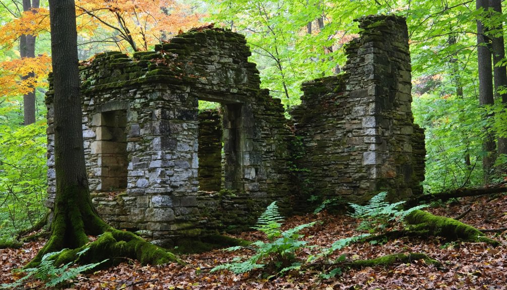
Jaite Mill Town: Industrial Ruins Along the Cuyahoga River
Between 1903 and 1906, Charles Jaite transformed a wooded tract along the Cuyahoga River into one of northern Ohio’s most ambitious industrial ventures. His kraft paper mill straddled Brecksville and Sagamore Hills, producing eight tons daily—cement sacks, flour bags, and industrial packaging that fed regional commerce.
The company town rose alongside: two-story workers’ houses, a general store, post office, and railroad depot serving a primarily Polish immigrant workforce.
Jaite History reflects early twentieth-century industrial optimism. The mill modernized in 1927, adopting Fourdrinier machinery, but southern competition forced its sale in 1951. Production limped through the 1980s before final demolition. A train order form dated March 18, 1965, issued in the original B&O station building, survives as a tangible connection to the site’s operational past.
Today’s Industrial Legacy stands ghostly. Concrete foundations crack beneath sumac and poison ivy. The B&O spur rusts toward the river. Most surviving structures bear distinctive yellow paint, a unifying aesthetic that marks the company town’s original footprint.
You’ll find company housing repurposed as park administration—preserving façades while erasing the mill’s ceaseless rhythm.
Little Egypt: A Forgotten Settlement Near Tinkers Creek
You’ll find Little Egypt’s story woven through the canal and railroad networks that once made this Bedford Township crossroads a thriving milling center along Tinkers Creek.
The settlement’s gradual decline culminated in 1951 when Walton Hills absorbed the remaining land, erasing Little Egypt from modern maps while its cemetery stones were moved eight miles east to Bedford.
Today, scattered foundations and the pyramid-shaped mound that gave Egypt its name survive within the Bedford Reservation, marking where Moses Gleeson’s mills and distillery powered a community that’s now returned to forest.
The Edmund and Charlotte Gleason House stands as a testament to the area’s prosperity, now recognized on the National Register of Historic Places.
Like the platform mounds surrounding a plaza at other historic sites, Little Egypt’s earthwork served as a distinctive landmark that defined the settlement’s identity and continues to intrigue visitors exploring the reservation’s trails.
Canal and Railroad Era
Fifteen years before Ohio achieved statehood, the Connecticut Land Company purchased the land that would become Little Egypt, conducting a critical survey in 1797 that cost Captain Joseph Tinker and several crewmen their lives when they drowned in the creek that still bears his name.
By 1813, settlers established a farming community at this strategic crossroads location. The settlement’s growth accelerated through canal transportation infrastructure that connected regional markets, while railroad expansion during the mid-1800s transformed Little Egypt into a genuine transportation hub.
Mills processing agricultural products and timber lined Tinkers Creek, supported by the Gleeson family’s steam-powered operations. This combination of waterways, canals, and rail lines enabled commercial enterprise beyond subsistence farming, attracting New England settlers seeking economic opportunity in Ohio’s Western Reserve territory.
Geographic Absorption by Walton Hills
Little Egypt’s identity as a distinct crossroads and mill settlement began to fade long before Walton Hills officially absorbed its territory in 1951.
You’ll find the historical significance of this hamlet erased by overlapping land transformations—Bedford Reservation claimed the bottomlands along Tinkers Creek, Astorhurst Golf Club occupied both valley and hilltop, and residential subdivisions replaced farmsteads.
When Bedford Township’s southwestern corner incorporated as the 6.8-square-mile village of Walton Hills, Little Egypt lost even its informal geographic boundaries.
The new municipality prioritized spacious country homes over the mixed-use rural-industrial pattern that had defined the settlement.
Today, realigned roads and parkland obscure the original crossroads layout, leaving Egypt Mound and Edmond Gleeson’s lone grave as fragile remnants of a community consumed by municipal growth.
Remnants Along Tinkers Creek
Though modern visitors to Bedford Reservation follow paved trails past Tinkers Creek‘s wooded ravines, few recognize they’re crossing ground where Little Egypt‘s mill economy once thrived.
Today’s Hermit’s Hollow Picnic Area conceals the 1840 steam sawmill site, while Astorhurst Golf Course supplanted a distillery operation. The powerful creek that drove this industrial heritage now flows through protected parkland, erasing nearly all physical evidence of settlement.
Scattered remnants mark Little Egypt’s landscape:
- Egypt Mound – pyramid-shaped earthwork on hillside east of Dunham Road that gave the settlement its name
- Gleeson brick house foundation traces – built 1840 south of Tinkers Creek
- Altered road alignments – Durham/Dunham and Egypt Roads bear vestigial routes through former crossroads
You’re free to explore these layers independently, tracing vanished communities beneath conservation land.
What Remains Today: Visiting Ghost Town Sites in the Park
When you arrive at the former Boston Mills area today—the epicenter of Helltown’s dark reputation—you’ll find typical national park scenery rather than the eerie tableau of boarded-up houses that haunted visitors’ imaginations for decades.
The National Park Service removed most abandoned structures by summer 2016, ending the physical evidence that fueled Helltown history for urban explorers.
What remains for ghost town exploration? Boston Cemetery still stands with its local lore intact, accessible during daylight hours.
Explorers can venture beyond the cemetery to discover ghost towns around Death Valley, where remnants of once-thriving communities tell stories of perseverance and desolation. These places offer a glimpse into the past, with crumbling structures and faded memories waiting to be uncovered. As the sun sets, the desolate landscape transforms, creating an eerie atmosphere that draws in adventurers seeking solitude and history.
The Stanford Road “Road to Nowhere” offers a visible relic—cracked pavement ending abruptly where the township abandoned it in the early 1980s.
Along trails, you’ll encounter the Jaite railroad spur and industrial remnants now rewilded. These fragments tell the valley’s displacement story without the trespassing risks that once defined Helltown visits.
Frequently Asked Questions
Are Overnight Camping or Paranormal Investigations Allowed at Helltown Sites?
No, you can’t camp overnight or conduct paranormal investigations at Helltown sites. National Park Service camping regulations prohibit unsanctioned activity, and there’s no evidence of paranormal permits being issued for closed, barricaded former Boston Township properties.
What Compensation Did Residents Receive During the 1974 Federal Buyout?
Residents received fair market value based on appraisals, with buyout details showing payments from the $34.5 million authorization. Many resident reactions were mixed, as some negotiated life estates while others reluctantly accepted cash compensation and relocated.
Can You Still Access the Original Boston Mills Cemetery Today?
Yes, you’ll find Boston Mills Cemetery publicly accessible at Main Street’s north end in historic Boston village. This 3.5-acre burial ground, active since 1814, preserves significant historical significance within Cuyahoga Valley National Park today.
Were Any Historic Buildings Relocated Rather Than Demolished During Park Creation?
The park didn’t pursue building relocation during land acquisition. Instead, you’ll find historic preservation focused on structures already within park boundaries, while non-historic buildings faced demolition, eliminating millions in maintenance costs.
How Do Local Communities Today View the Helltown Folklore and Legends?
Community perceptions divide sharply: local historians actively debunk Helltown myths, emphasizing displacement over demons, while businesses cautiously leverage folklore impact for tourism. You’ll find residents frustrated that ghost stories overshadow their documented canal-era heritage.
References
- https://colonialghosts.com/tale-of-helltown-ohio/
- https://ohioghosttowns.org/top-10-ghost-towns/
- https://allthatsinteresting.com/helltown-ohio
- https://www.ideastream.org/community/2021-10-29/if-hell-town-exists-where-in-cuyahoga-valley-national-park-is-it
- https://www.atlasobscura.com/places/helltown-ohio
- https://clevelandmagazine.com/articles/suburban-legend/
- https://www.onlyinyourstate.com/experiences/ohio/abandoned-place-story-cuyahoga-valley-oh
- https://www.americanhauntingsink.com/helltown
- https://www.ghostsofohio.org/lore/ohio_lore_36.html
- https://thelittlehouseofhorrors.com/helltown/


