You’ll discover numerous authentic ghost towns within an hour of Durango, including Animas Forks at 11,200 feet—Colorado’s highest ghost town with nine preserved buildings from the 1870s silver boom. The Alpine Loop connects seven historic camps across 63 miles of rugged terrain, while Ironton preserves a dozen structures from its 1,000-resident peak. Cold War-era Graysill Mines adds uranium-mining history from 1945-1960. These sites require high-clearance 4×4 vehicles and proper altitude acclimatization, with ideal visiting conditions from late May through October when mountain passes remain accessible for exploration.
Key Takeaways
- Animas Forks, established in 1873 at 11,200 feet, features nine stabilized buildings including the Bay Window House and restored jail.
- Ironton once housed over 1,000 miners with 100 structures; today approximately a dozen buildings remain, including the circa-1891 White House.
- Eureka and Howardsville were early mining settlements, with Howardsville serving as La Plata County’s first seat until 1882.
- Graysill Mines, a Cold War-era uranium camp twenty-five miles behind Purgatory Resort, contains weathered structures and industrial ruins.
- The Alpine Loop Back Country Byway connects seven ghost towns across 63 miles, requiring high-clearance 4×4 vehicles and open May-October.
Animas Forks: Colorado’s Highest Elevation Ghost Town
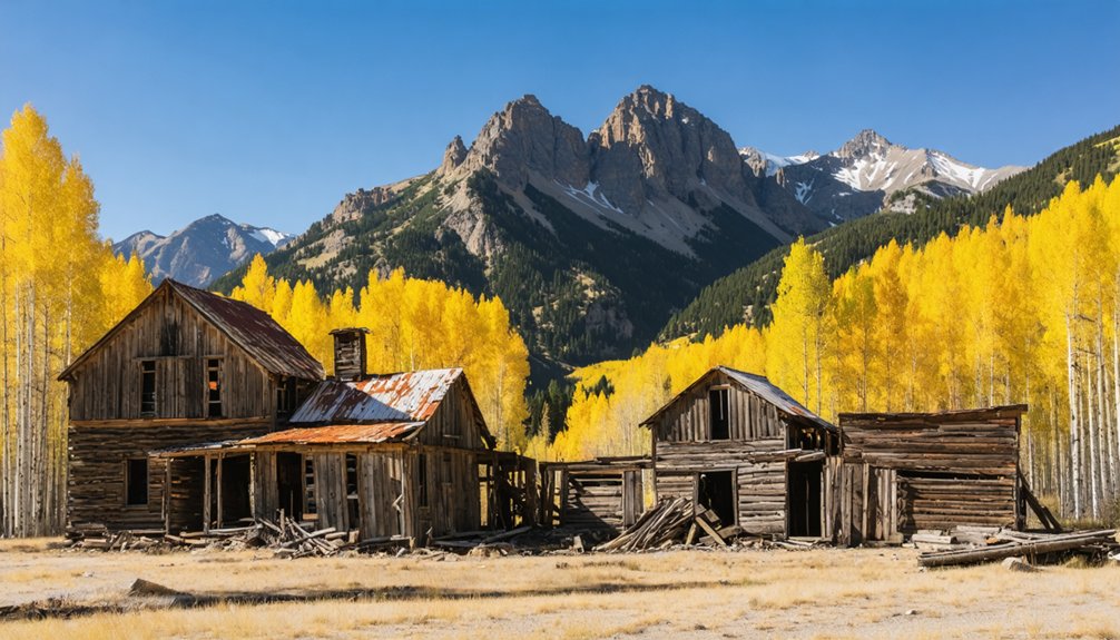
Perched at approximately 11,200 feet in a narrow canyon of the San Juan Mountains, Animas Forks holds the distinction of being Colorado’s highest elevation ghost town and one of the loftiest mining camps ever established in North America.
You’ll find this remarkable site twelve miles northeast of Silverton along the Alpine Loop’s rugged backcountry byway.
Animas Forks history began with gold and silver discoveries in 1873, rapidly transforming into a bustling community of over 450 summer residents by the 1880s.
The town’s notorious 1884 blizzard buried buildings under twenty-five feet of snow, forcing residents to tunnel between structures.
During its peak years, Animas Forks featured essential frontier amenities including a hotel, general store, saloon, and post office that served the mining community.
Today, nine stabilized buildings survive, showcasing Animas Forks architecture through structures like the iconic Bay Window House and the town’s oldest building—the restored jail—offering you authentic glimpses into Colorado’s extreme high-altitude mining heritage.
The Bureau of Land Management has carefully preserved significant structures including the Columbus Mine and Gustavson House, allowing visitors to experience this atmospheric piece of Colorado’s mining past.
Graysill Mines: A Cold War-Era Uranium Camp
Twenty-five miles behind Purgatory Mountain Resort, you’ll find the scattered remains of Graysill, a high-elevation uranium camp born from the post-World War II atomic weapons rush.
While Animas Forks thrived on silver in the 1870s, Graysill’s 450 mining claims and modest ore shipments served Cold War nuclear programs from roughly 1945 into the early 1960s.
Today only a few weathered structures mark where about 20 year-round miners once extracted radioactive ore at nearly 11,000 feet, making this one of Colorado’s most remote and historically distinct ghost camps. Among the abandoned relics is a 1890s narrow gauge tank car, originally used to haul oil to the Vanadium Mill near Placerville before being repurposed to supply water at Graysill during its operational years from 1949 to 1960. Prospectors arrived with Jeeps and Geiger counters to seek uranium riches throughout the Four Corners region during the atomic boom.
Post-WWII Atomic Boom
While the nineteenth-century silver camps faded into memory, the San Juan Mountains witnessed a new extractive rush in the years after 1945—this time for uranium and vanadium, minerals suddenly critical to Cold War atomic programs.
The Graysill Mine, situated at 10,879 feet near Bolam Pass, emerged as part of this federal supply chain for nuclear materials.
Uranium mining and vanadium production intensified across the Four Corners region, driven by Manhattan Project legacy demands and Atomic Energy Commission purchasing incentives.
By the early 1950s, roughly 450 claims blanketed the Graysill district, though actual shipments remained modest—about 3,000 tons annually.
Vanadium Corporation of America developed dedicated infrastructure here, including water systems and year-round camps, reflecting the strategic importance Washington placed on domestic ore sources during atomic escalation.
The ore traveled to Durango’s processing mill, where workers separated red cake vanadium from yellow cake uranium destined for weapons programs.
The uranium boom shaped popular culture of the era, spawning songs like “Uranium Fever” and “Uranium Crazy” that reflected the excitement and risks of prospecting for radioactive minerals.
Remote Industrial Ruins
The Graysill mining camp stands at 10,879 feet near Bolam Pass, twenty-two miles north of Durango along US 550, where uranium and vanadium extraction replaced silver as the economic driver between 1949 and the early 1960s.
You’ll find industrial decay scattered across three miles of mining claims accessible via County Road 578—a route demanding four-wheel-drive capability. Fewer than twenty men maintained year-round residence here, despite 450 active claims at peak operation.
The historical remnants you’ll encounter include collapsed worker housing and processing facilities that once fueled Cold War atomic programs. Radon gas and radioactive contamination remain present, with tailings entombed at the nearby Bodo Canyon disposal site. The site is located approximately 120 acres and represents the broader legacy of uranium extraction that supported the Manhattan Project and subsequent Cold War operations. Operations began with exploratory drilling in 1945, two years before the first commercial production.
Summer access provides the safest window to explore this high-altitude reflection of atomic-age prospecting.
Exploring the Alpine Loop Back Country Byway
Connecting the historic mining towns of Lake City, Ouray, and Silverton, the Alpine Loop Back Country Byway traces 63 miles of rugged terrain through Colorado’s San Juan Mountains.
You’ll need a high-clearance four-wheel-drive vehicle to tackle this route, which climbs to 12,800 feet at Engineer Pass. The journey passes seven ghost towns, including Animas Forks, where 1800s mining relics stand frozen in time.
What awaits on the Alpine Loop:
- Unobstructed alpine vistas from windswept tundra above treeline
- Wildlife encounters in mountain meadows and spruce forests
- Weathered structures of Capitol City and other abandoned settlements
- Trails accessing three 14,000-foot peaks from Silver Creek and Grizzly Gulch
Open late May through October, these former toll roads now offer unrestricted access to Colorado’s mining heritage. Starting from Lake City, travelers can complete the loop clockwise via Cinnamon Pass for optimal driver views, or counter-clockwise for easier ascents in less powerful vehicles. The region’s rich volcanic activity created the precious material deposits that sparked the mining boom and settlement of these now-abandoned towns.
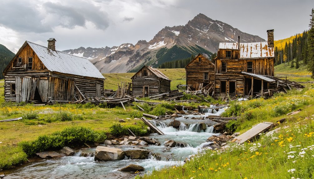
Ironton and the Red Mountain Pass Silver District
When you visit Ironton’s scattered ruins along Highway 550, you’re standing at what was once a bustling junction that swelled from 200 winter residents to nearly 1,000 during summer mining seasons in the mid-1880s.
The town’s location seven miles south of Ouray made it a critical supply hub between the Red Mountain camps and Silverton, servicing two daily Denver & Rio Grande trains that hauled ore and freight through the district.
Peak Population and Transport Role
After John Robinson discovered lead and silver ore on Red Mountain in August 1882, the settlement that would become Ironton exploded with activity.
By year’s end, more than 1,000 men had staked their claims to fortune. Just eight months later, April 1883 saw over 100 structures standing—including 12 saloons, four restaurants, and even a bookstore serving independent prospectors.
The town’s Ironton legacy centered on its essential transport role. You’d have witnessed constant stagecoach and wagon traffic along Mears’ toll roads, with two daily trains hauling ore and supplies.
Mining infrastructure connected Ouray to Red Mountain District camps through this critical hub.
- 1890 census recorded 323 residents, though thousands more worked nearby camps
- Silver production soared until the 1893 panic destroyed prices overnight
- Railroad ceased operations in 1921
- Population plummeted to just 48 by 1910
Current Ruins and Preservation Status
Though time and the elements have claimed most of Ironton’s built environment, approximately a dozen structures still stand at the south end of the former townsite, offering tangible evidence of the settlement’s frontier past.
You’ll find the circa-1891 “White House” (Paymaster Mine Superintendent’s residence) and an 1889 dwelling with its covered outhouse passageway—both frequently photographed remnants of Ironton history.
The Red Mountain Project has stabilized two houses using grant funding, addressing deterioration from harsh winters and fire damage while preserving their weathered character.
Ouray County owns the site, and the Historical Society maintains it with interpretive signage.
Ghost town accessibility here is exceptional: you’ll reach Ironton via a short dirt road 150 yards from Highway 550, making self-guided exploration straightforward.
Eureka, Howardsville, and Other San Juan Mining Camps
The discovery of placer gold along the Animas River in 1860 by Charles Baker sparked the first wave of mining activity in what would become a network of San Juan Mountain camps, though the Ute Tribe’s territorial rights forced prospectors to abandon their claims within a year.
The 1873 Brunot Treaty finally opened the region, establishing Eureka history at 9,862 feet elevation along a mountainside designed to minimize avalanche danger.
Howardsville significance emerged as La Plata County‘s first seat, governing all southwestern Colorado territory until railroad arrival in 1882.
Animas Forks, twelve miles northeast of Silverton, now appears on the National Register of Historic Places.
Freedom-seekers found:
- Saloons “the finest anywhere” on Eureka’s main street
- Independence from governmental oversight in remote mountain camps
- Opportunity beyond restrictive eastern society
- Untamed frontier demanding self-reliance
Planning Your Ghost Town Adventure: Season and Vehicle Requirements
Vehicle suitability isn’t negotiable on these historic mining routes. High-clearance 4×4s with low-range gearing handle the embedded boulders, steep climbs, and shelf roads hugging vertical drop-offs.
Passenger cars won’t make it. July and August bring afternoon thunderstorms, so plan early-morning departures.
September delivers clearer skies but watch for sudden snowfall. Rental Jeeps and guided tours work if you lack proper equipment—freedom here means matching capability to terrain, not wishful thinking on rutted backroads.
Safety Tips for High-Elevation Exploration
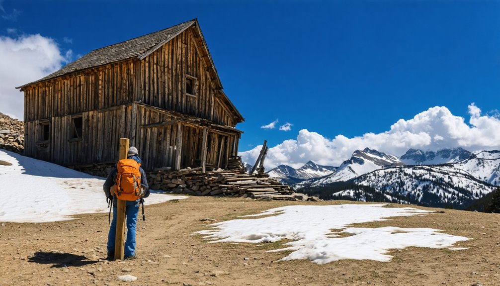
Reaching these abandoned settlements means climbing above 9,000 feet, where oxygen pressure drops roughly 30% compared to sea level and your body works harder with every breath.
Altitude acclimatization demands patience—spend 24 hours in Durango before ascending, then limit sleeping elevation gains to 1,000 feet daily above 10,000 feet.
Hiking hydration becomes critical: drink every 30 minutes, roughly doubling your usual intake, and skip alcohol during your first days at elevation.
Watch for these warning signs:
- Pounding headache with nausea—your brain protesting thin air
- Stumbling on simple terrain—coordination loss signals danger
- Gasping while resting—immediate descent required
- Confusion about basic decisions—potentially life-threatening
Pack waterproof layers, high-SPF sunscreen, and calorie-dense snacks.
Pace yourself deliberately: one breath per step on steep grades, with breaks every 20 minutes.
Preserving Colorado’s Mining Heritage for Future Generations
When you walk through Durango’s ghost towns, you’re stepping into landscapes that dozens of organizations are racing to protect before weather, vandalism, and time erase them completely.
Colorado Historical Foundation holds over 100 conservation easements statewide, safeguarding these cultural resources through legally binding agreements that require ongoing maintenance and interpretation.
You’ll find successful models like Silver Plume, where $325,000 in combined public-private funding purchased an entire mining landscape.
The state’s Abandoned Mine Reclamation Program balances safety with heritage, spending $2 million yearly to secure 23,000 hazardous features while preserving landmarks like Smuggler Mine’s 40-foot headframe.
Groups like San Juan County Historical Society translate this mining documentation into accessible exhibits at facilities including the Mining Heritage Center and Mayflower Mill, ensuring future generations understand your freedom to explore responsibly.
Frequently Asked Questions
Are There Any Ghost Towns Near Durango Accessible by Regular Passenger Car?
The early bird catches the worm—Eureka offers excellent ghost town accessibility via paved highway then graded dirt. You’ll find passenger car routes practical in dry conditions, reaching authentic mining relics without requiring 4×4 capability or sacrificing your vehicle’s undercarriage.
Can You Camp Overnight at Animas Forks or Other Ghost Town Sites?
Yes, you can camp overnight at Animas Forks under BLM camping regulations allowing 14-day dispersed stays. The ghost town amenities include vault toilets but no trash service, so pack out all waste responsibly.
Are Guided Ghost Town Tours Available From Durango Year-Round?
No, guided ghost-town tours from Durango aren’t year-round. While downtown walking ghost tours operate nightly across all seasons, Jeep excursions to remote sites like Animas Forks run only June–September due to seasonal availability and high-altitude road conditions.
Which Ghost Towns Near Durango Are Best for Photography?
Animas Forks offers you the strongest subject variety with nine stabilized buildings and alpine backdrops. For photography tips, visit during morning’s golden hour. Best times are summer for wildflowers or winter for dramatic snow contrasts.
Do Any Ghost Towns Charge Admission Fees or Require Permits?
Most ghost towns near Durango don’t charge fees—Animas Forks and Graysill Mines remain free historic sites. Admission policies favor open exploration, though permit requirements apply to Alpine Loop’s 4×4 routes, not the towns themselves.
Exploring the nearby landscapes can also lead to haunting stories of Fairmount’s past, where echoes of bygone eras linger in the air. These tales often enrich the experience of visiting the ghost towns, allowing for a deeper connection to the history of the region. Each crumbling structure and forgotten pathway seems to whisper secrets waiting to be uncovered.
References
- https://www.durango.com/colorado-ghost-towns/
- https://vacationdurango.com/blog/ghost-towns-near-durango-co/
- https://www.colorado.com/articles/colorado-ghost-towns
- https://www.durangorivertrippers.com/blog/exploring-colorado-ghost-towns/
- https://www.islands.com/2061852/colorado-abandoned-ghost-towns-once-thriving/
- https://www.uncovercolorado.com/ghost-towns/
- https://www.tripadvisor.com/ShowTopic-g33397-i907-k4634150-Best_ghost_towns_within_driving_distance_of_Durango-Durango_Colorado.html
- https://www.durango.com/animas-forks/
- https://savingplaces.org/stories/ghost-of-a-chance-animas-forks-colorado
- https://airial.travel/attractions/united-states/animas-forks/animas-forks-ghost-town–nHtWGSb


