You’ll find Falk, the most accessible ghost town, just 6–7 miles southeast of Eureka within Headwaters Forest Reserve—reachable via a half-mile walk from Elk River Trailhead. Other notable sites include Samoa’s decaying pulp mill structures along Humboldt Bay, remote Camp Grant near the South Fork Eel River on private land, and semi-abandoned Bridgeville along State Route 36. These settlements collapsed between the 1880s and 1940s as redwood timber reserves dwindled, leaving foundations, artifacts, and eerie remnants across Humboldt County’s landscape that reveal the region’s dramatic boom-and-bust logging history.
Key Takeaways
- Falk, the most accessible ghost town, lies 6–7 miles southeast of Eureka within Headwaters Forest Reserve along Elk River Trail.
- Samoa features decaying pulp mill structures and abandoned infrastructure from the mill that operated between 1965 and 2010.
- Camp Grant, a Civil War-era Union Army post ghost town, sits along South Fork Eel River on private ranch land.
- Bridgeville, a semi-abandoned stagecoach waystation on State Route 36, retains around 25 residents and a historic river bridge.
- Scotia represents another lumber company town in the region established during the redwood logging boom era.
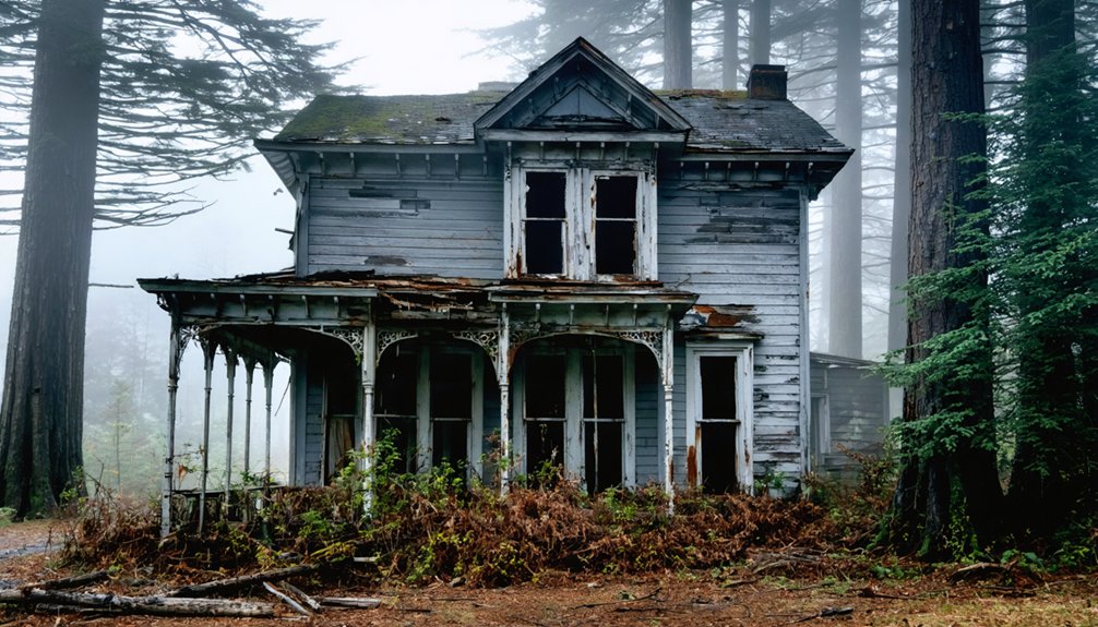
Falk: The Most Accessible Ghost Town in the Redwoods
Falk stands as the most visitor-friendly ghost town remnant in California’s redwood belt, offering an unusual combination of historical significance and practical accessibility.
Falk offers California’s most accessible ghost town experience, blending redwood belt history with remarkably easy forest access.
You’ll find the site just 6–7 miles southeast of Eureka within Headwaters Forest Reserve, reachable via an easy half-mile walk along Elk River Trail from a paved county road trailhead.
The BLM-managed site balances cultural significance with ecological restoration—second-growth redwoods actively reclaim former streets while interpretive markers identify building foundations and artifact scatters.
You’ll explore the restored locomotive barn education center, examine documented remnants of housing and industrial infrastructure, and read the commemorative plaque marking this National Register-listed archaeological district.
The forest’s recovery demonstrates how nature absorbs human settlement, creating a landscape where logging history meets old-growth conservation.
Noah Falk established the community in the 1860s, founding what would become a thriving logging operation centered around the Elk River Mill and Logging Company.
The preserved structures provide insights into the lives of loggers and their families who built this remote community.
The Rise and Fall of Falk Mill and Lumber Company
Behind the quiet forest trails and weathered foundations lies a quintessentially American story of industrial ambition and family entrepreneurship.
In 1884, Noah Falk’s sons built the Falk Mill on 9,000 acres acquired through the Timber and Stone Act at $2.50 per acre. The operation deployed cutting-edge logging technology—band saws and Dolbeer steam donkeys replaced hand-sawing and ox teams, slashing labor costs while boosting output.
By 1886, the “Falk No. 1” locomotive hauled redwood from forest to mill to Elk River docks. The 1906 San Francisco earthquake drove unprecedented demand, cementing Falk’s prosperity.
The town grew to accommodate lumberjacks and their families from various countries, featuring essential amenities like a cookhouse, dance hall, general store, post office, and school.
Yet finite timber reserves sealed its fate. When the last accessible redwoods fell in 1937, the mill closed permanently, leaving 300-400 residents to scatter. The vacant buildings gradually deteriorated and eventually became part of the soil within what is now the Headwaters Forest Reserve.
What You Can Still See at the Falk Townsite Today
Today’s visitor to the Falk townsite confronts an almost paradoxical landscape—a National Register archaeological district where virtually nothing stands above ground.
After owners demolished and burned the town’s buildings in 1979, forest regeneration swallowed the mill and residential streets. You’ll find faint building foundations along the first half-mile of Elk River Trail, rose bushes and English ivy persisting from former gardens, and interpretive signs marking where structures once stood.
The restored locomotive barn serves as BLM’s education center, displaying artifacts—medicine bottles, kitchenware, logging tools—recovered from subsurface excavations. The interpretive center occupies the old roundhouse, a remnant from Falk’s railroad operations that shipped lumber to the Bay.
Archaeological features like postholes and refuse deposits reveal the buried town grid. Falk joins nearly 60 other sites in Humboldt County on the National Register of Historic Places. This ghost-town atmosphere captures Falk’s transformation from industrial company town to protected redwood reserve.
How to Visit Falk via the Headwaters Forest Reserve Trail
The journey to Falk’s archaeological district begins at the Elk River Trailhead, positioned at the terminus of paved Elk River Road approximately 15 minutes from Eureka.
Access Falk’s archaeological treasures via Elk River Trailhead, a convenient 15-minute drive from Eureka on paved Elk River Road.
You’ll find year-round paved parking accessed via Herrick Avenue exit off US Highway 101.
The 11-mile round-trip trail features an initial paved mile suitable for limited mobility exploration, reaching Falk townsite at approximately one mile.
Hiking tips include utilizing the educational signage and two bypass trails along the first mile’s southside.
Trail safety requires staying on designated paths and avoiding entry into old-growth forest sections. The trail includes landmarks every mile to help you track your progress throughout the hike.
You’re permitted bicycles and leashed dogs for the first three miles.
Day hiking only—no overnight camping allowed.
Public transportation doesn’t serve the reserve, requiring personal vehicle access for your visit. The trail features several bridges that cross the river at various points along the route.
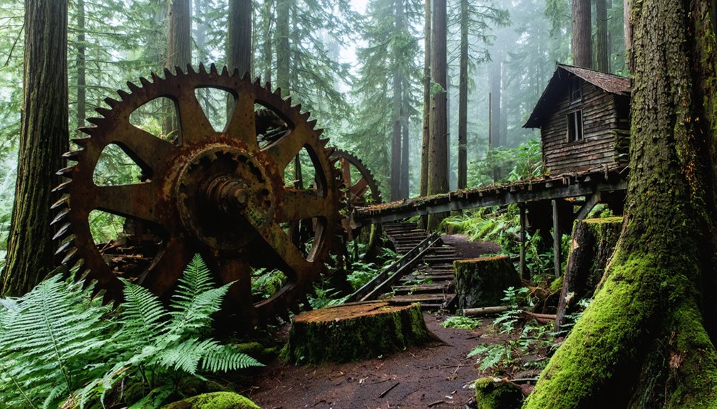
Samoa: Industrial Ruins Along Humboldt Bay
You’ll find Samoa’s industrial past still visible in decaying mill structures and abandoned infrastructure scattered across the peninsula’s shoreline.
The Samoa Pulp Mill, which processed wood into pulp from 1965 until permanent closure in 2010, stands idle alongside remnants of what was once the world’s largest redwood lumber operation under Hammond Lumber Company.
Today, the Humboldt Bay Harbor District controls the site, leaving portions accessible to visitors while hazardous zones remain fenced off from public entry.
The site contains approximately 30 bulk storage tanks holding about 4 million gallons of highly alkaline pulping liquor, along with thousands of gallons of acids and fuel that pose ongoing environmental risks to Humboldt Bay’s ecosystem.
Meanwhile, the Timber Heritage Association preserves part of Samoa’s industrial legacy through its collection housed in the historic railroad shop complex of the former Hammond Lumber Company, which includes the oldest remaining wooden roundhouse in the United States.
Decaying Mill Town History
When John Vance’s lumber empire spanned 10,000 acres of timber in 1892, his estate already controlled multiple mills, railroads, ships, and hotels across the Humboldt Bay region.
The Samoa industrialization accelerated when his new mill produced first lumber in 1894, employing 200 mill workers and 120 in the woods.
A.B. Hammond purchased the operation for $1,000,000 in 1900, transforming it into the largest redwood lumber mill anywhere.
This company-town economy dominated the peninsula for 56 years until Georgia-Pacific’s pulp mill arrived in the early 1960s.
Pulp mill pollution became notorious by the late 1980s, when facilities discharged 40 million gallons daily of untreated wastewater containing dioxins and furans.
The mill closed in 2008, leaving industrial ruins.
Accessing Samoa’s Abandoned Zones
How do you approach a 72-acre industrial ghost site where corroding tanks once threatened to spill over a million gallons of hazardous liquids into sensitive bay waters?
Post-2013 EPA emergency stabilization transformed Samoa’s pulp mill from active hazard to regulated brownfield. The 12-story Reboiler Building and 300-foot smokestack still dominate the skyline, but restricted access now protects both visitors and Humboldt Bay’s threatened species.
Security fencing surrounds core process areas containing asbestos-laden debris stockpiles and petroleum-contaminated soils. Harbor District ownership enables industrial preservation alongside ecological restoration—balancing heritage-rail tourism with oyster aquaculture expansion.
You’ll find legal viewpoints from adjacent waterfront parcels and public roads, though direct entry requires coordination with District authorities managing the slow shift from abandoned ruin to mixed coastal redevelopment.
Camp Grant: A Remote Ghost Town on the South Fork Eel River
You’ll find Camp Grant’s remnants tucked along the South Fork Eel River in remote northern Mendocino County, roughly 60 miles south of Eureka, where a Civil War–era Union Army post once anchored a dispersed ranching community.
The settlement grew from military operations by Company E of the 1st Battalion of Native California Cavalry into a scattered agricultural district known for orchards and cattle operations on the river’s bottomlands.
Reaching the site today requires traversing winding backcountry roads through steep, forested terrain, as Camp Grant sits well off Highway 101 with no official ghost-town signage or visitor facilities.
Location and Historical Context
The name derives from a Union Army camp established during the Civil War, when Company E, 1st Battalion, Mountaineer Infantry operated from this base.
After the war, ranching families transformed the site into an agricultural settlement while preserving its military-era designation.
Accessing the Abandoned Site
Finding Camp Grant requires careful planning, since the ghost town lies on private ranch land roughly 2–3 miles from the former communities of Weott and Dyerville along the South Fork Eel River corridor.
Exploring ghost towns near Auburn California can be equally challenging, as many of them are tucked away in remote areas that are not easily accessible. A visit to these historical sites often reveals remnants of the past, offering a glimpse into the lives of those who once inhabited them. Careful navigation and respect for the local landowners are crucial for a rewarding experience.
Camp Grant access demands landowner permission and awareness of serious river hazards.
Before attempting any visit, understand these practical realities:
- Private ranch parcels surround the former Hansell Ranch orchards where Camp Grant stood, making unauthorized entry illegal trespass.
- Eel River floods historically surge over 40 feet at Dyerville, creating unstable banks and dangerous seasonal conditions.
- Dense riparian vegetation and downed timber obscure old wagon routes and townsite remnants.
- No designated public trails lead to the abandoned settlement—access follows unmaintained ranch tracks off Highway 101.
Respect property rights and natural hazards when researching this remote ghost town.
Bridgeville and Other Vanishing Settlements Along Highway 36
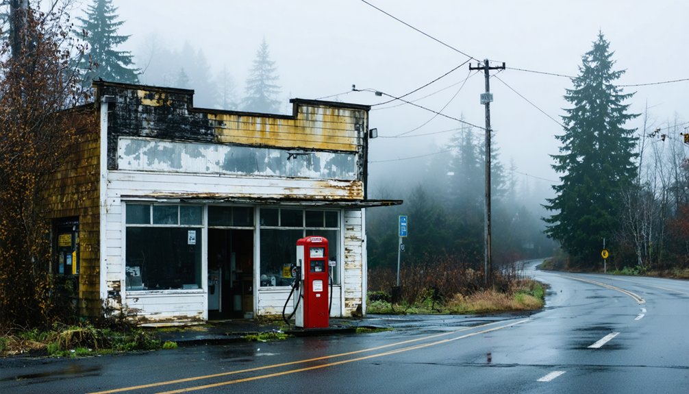
Along State Route 36 between Fortuna and Ruth Lake, Bridgeville occupies 83 acres of riverfront land that once anchored Humboldt County’s primary overland route south.
The settlement’s Bridgeville history reveals its transformation from essential stagecoach waystation to semi-abandoned curiosity, with about five of eight core buildings still inhabited by roughly 25 residents.
Highway 36 significance diminished after railroads and US 101 redirected traffic, leaving broken windows, blackberry-choked structures, and “No Trespassing” signs where miners and loggers once stopped.
You’ll find the town’s bridge still spans the Van Duzen River at the Alderpoint Road junction, serving scattered ranches.
Multiple sales since 2002—including eBay auctions fetching $700,000 to $1.8 million—reflect failed redevelopment attempts by religious groups and private buyers unable to overcome infrastructure collapse.
The Haunted Legacy of Humboldt County’s Abandoned Towns
Deep within Headwaters Forest Reserve, the abandoned logging town of Falk stands as Humboldt County’s most documented haunted landscape. Its spectral reputation was formalized in 2012 when the Bureau of Land Management added the site to the National Register of Historic Places as an archaeological district.
Founded in 1884, this company town housed 400 residents before the Great Depression triggered its collapse.
Today you’ll find only ruins where ghostly encounters merge with logging memories:
- Redwoods consume rotting foundations where families once lived
- A restored locomotive barn marks the spectral railroad terminus
- Interpretive trails trace invisible streets through forest shadows
- Archaeological artifacts document sudden abandonment—personal effects left behind when residents fled
Park rangers acknowledge Falk’s uncanny “presence,” while local lore recalls a shotgun-wielding caretaker defending the dying settlement against trespassers.
Understanding the Logging Boom That Built and Abandoned These Communities
When gold fever seized California in 1849, Humboldt County‘s coastal redwood forests became the lumber yard for a rapidly expanding frontier. By 1854, nineteen million board feet flowed from Eureka’s deepwater port to San Francisco’s booming settlements.
Seven steam-powered mills operated in Eureka alone, transforming old-growth stands into profit.
Logging technology evolved rapidly—steam donkeys replaced oxen, railroads pushed deeper into remote valleys, and mechanical innovations enabled entire groves to vanish.
Companies built purpose-built towns like Falk and Scotia near timber stands, housing Scandinavian, Irish, and Nova Scotian workers in company-owned bunkhouses.
This created absolute community dependence. Company stores controlled supplies, wages, and housing.
When accessible timber disappeared by the 1870s–1880s, operations moved farther inland. Mills closed, markets shifted, and these isolated communities emptied—leaving ghost towns scattered across Humboldt’s cutover landscape.
Frequently Asked Questions
Are Ghost Town Visits Near Eureka Suitable for Children and Families?
You’ll find Falk Historic Logging Ghost Town offers family friendly activities with supervised trails just six miles from Eureka, though safety considerations require sturdy footwear for muddy paths and watching younger children on uneven foundations.
What Camping Options Exist Near Falk and Other Humboldt Ghost Towns?
You’ll need to base at nearby state parks or Eureka lodging since Headwaters Reserve prohibits camping. Bring appropriate camping gear and check local regulations for BLM dispersed sites before exploring Humboldt’s ghost towns independently.
Do I Need Permits to Explore Ghost Town Sites in Humboldt County?
You’ll generally need permits for organized activities, research, or artifact collection on BLM lands like Falk. Day hiking typically doesn’t require permits, but always verify local regulations and respect private property boundaries before exploring.
What Wildlife Might I Encounter While Visiting Abandoned Logging Towns?
Nature reclaims what loggers left behind. You’ll encounter wildlife sightings including Roosevelt elk, black-tailed deer, black bears, bobcats, spotted owls, salamanders, and banana slugs thriving in local ecosystems where second-growth redwoods now blanket former mill towns.
Can I Bring My Dog to Ghost Town Trails in Headwaters Forest?
Yes, you can bring your dog on dog friendly trails to Falk ghost town—only the first three miles of Elk River Trail. Keep them leashed for pet safety and watch for wildlife near riparian zones.
References
- https://thelumberjack.org/2019/11/15/humboldt-county-ghost-towns/
- https://tisqui.github.io
- https://nvtami.com/2022/11/13/humboldt-pershing-county-ghost-towns/
- https://www.visitredwoods.com/listing/falk-historic-logging-ghost-town/526/
- https://www.savetheredwoods.org/blog/spooky-redwoods-ghost-town-remains-a-presence/
- https://redwoodburl.com/the-haunted-redwoods-of-humboldt-county/
- https://guides.lib.berkeley.edu/mapsandmore/ghosttowns2019
- https://en.wikipedia.org/wiki/Camp_Grant
- https://now.humboldt.edu/news/local-ghost-town-added-national-register-historic-places-0
- https://lostcoastoutpost.com/2024/jan/9/historic-falk-abandoned-lumber-town-headwaters-for/


