You’ll discover Thurber just 75 miles west of Fort Worth, once Texas’s coal capital with 10,000 residents before vanishing by 1939. Closer in, Carlton’s abandoned cotton gins stand empty after the town collapsed from 750 to 70 residents. Eliasville boomed with oil in 1921, then crashed to nearly nothing. Medicine Mound burned in 1933’s suspicious fire, while Old Bluffton lies submerged beneath Lake Buchanan since 1937. Each town’s story reveals why these communities disappeared and what physical remnants you can still find today.
Key Takeaways
- Thurber, 75 miles west of Fort Worth, was Texas’s coal capital with 10,000 residents before oil replaced coal in the 1920s.
- Carlton thrived as a cotton hub until rail service ceased in 1940, leaving abandoned storefronts and a population of only 70.
- Eliasville experienced an oil boom in 1921 attracting 1,000 residents before quick depletion reduced the population to 100 by 1980.
- Bug Tussle, named after fighting tumblebugs, features an abandoned general store and became known for unique marriage certificates.
- Indian Gap’s 1913 school served rural areas until 1959, remaining vacant for sixty years before demolition in October 2020.
Thurber: The Industrial Giant That Vanished
While Fort Worth boomed in the late 19th century, a different kind of giant emerged 75 miles to the west.
Thurber wasn’t just another mining camp—it was Texas’s bituminous coal capital, producing 3,000 tons daily by 1919. You’d have found 8,000-10,000 residents living behind barbed wire fences in a completely controlled company town.
The Texas and Pacific Coal Company owned everything: homes, stores, churches, even the 650-seat opera house. Workers—Black miners from Indiana, immigrants from Italy, Poland, Hungary, Mexico—earned scrip redeemable only at company commissaries. Miners also used steel washers as tallies on coal cars to track their daily production.
Total control: company housing, company stores, company money—workers lived entirely within the Texas and Pacific Coal Company’s economic grip.
When oil replaced coal in the 1920s, Thurber’s decline came swiftly. The brick plant closed in 1930, offices in 1933. By 1939, the town was largely dismantled as focus shifted to oil fields.
Carlton and Belle Plain: Agricultural Empires Turned to Dust
Unlike Thurber’s industrial machinery, Carlton and Belle Plain built their futures on soil and rainfall—gambles that Central Texas agriculture couldn’t sustain.
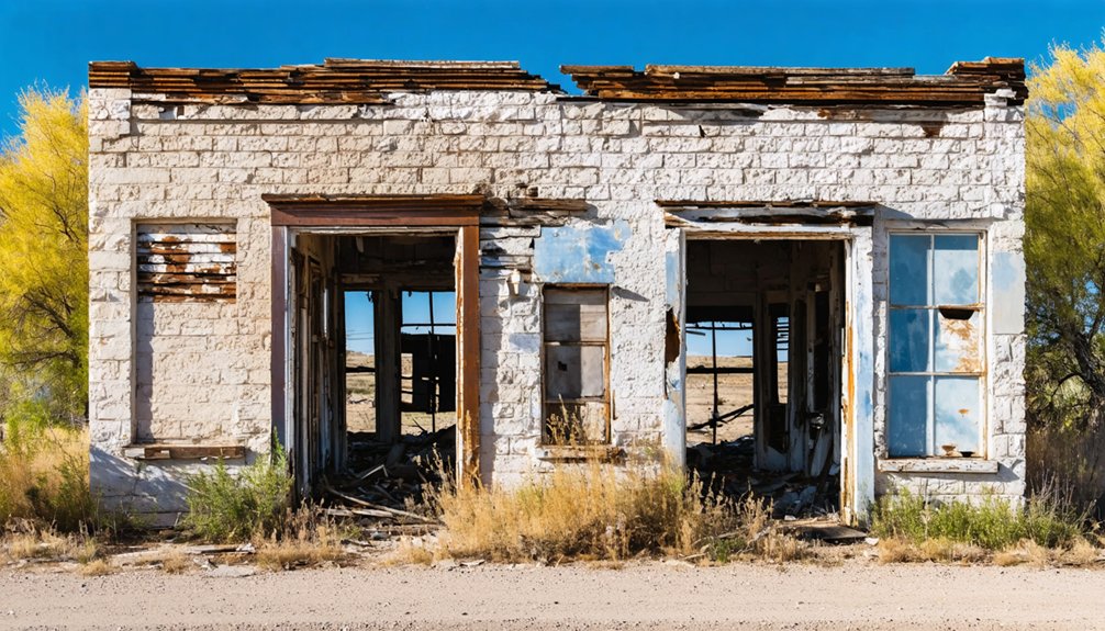
Carlton thrived from 1877 as a cotton hub at FM 219 and FM 1744, swelling from 150 residents in 1907 to 750 by 1910. You’ll find its abandoned storefronts marking where gins once processed thousands of bales.
When rails disappeared in 1940, so did Carlton’s purpose—population crashed to 70 by 1980. Many buildings still exist but are abandoned today, with notable remnants including sowing machines and unfinished projects scattered throughout the former town.
Belle Plain’s agricultural decline started earlier. Callahan County’s 1886 drought destroyed crops before the Texas and Pacific Railroad bypassed the town entirely, stripping away Belle Plain College and its Methodist community. The town, established in 1875 and named after Katie Belle Magee, the first child born there, once boasted a local newspaper and mercantile shops before growth halted.
Both settlements demonstrate how agricultural decline and community transformation leave physical scars: weathered buildings surrounded by working ranches that no longer need town services.
Eliasville and the Oil Boom That Faded
Water-powered prosperity drew settlers to the Clear Fork of the Brazos River in southern Young County during the 1870s, where rancher J. L. Dobbs established his mill.
The Donnell brothers built ranches in 1876, and by 1879 their flour mill powered local agriculture.
You’d have found a quiet farming community called Eliasville—named for storekeeper Elias DeLong—until the 1921 oil boom transformed everything.
Eliasville history shifted dramatically as developers sold lots, built brick storefronts around a town square, and welcomed nearly 1,000 residents.
Churches, schools, and banks rose on anticipation of railroad wealth.
But oil reserves spent quickly, fires consumed unrebuilt blocks, and population collapsed to 100 by 1980.
The town faced frequent fires that destroyed much of its infrastructure during the decline.
Today’s scattered remnants mark where speculative fortune evaporated.
Railroad service ceased in the late 1960s, severing the town’s final connection to economic recovery.
Medicine Mound: Where Fire and Time Erased a Community
Railroad speculation drove Eliasville’s fleeting wealth, but farther northwest in Hardeman County, an even more dramatic catastrophe awaited the town of Medicine Mound.
You’ll find this ghost town twelve miles southeast of Quanah, named for four sacred dolomite hills rising 1,700 feet above the plains. Understanding Medicine Mound history requires knowing the Comanche significance of these peaks—warriors fasted here seeking visions, and tribal members were buried on sacred ground before forced removal in the 1870s cleared land for settlement.
Before becoming a ghost town, Medicine Mound’s dolomite peaks served as sacred Comanche burial grounds and vision quest sites.
The Kansas City, Mexico & Orient Railway sparked the town’s birth around 1908, attracting 500 residents and twenty-two businesses by 1929. The community once supported multiple banks, reflecting its brief period of prosperity.
Then catastrophe struck: on March 31, 1933, fire—allegedly arson—consumed the wooden town. The blaze, set by Ella Tidmore, caused over $50,000 in damages and left only two buildings standing.
Depression, drought, and declining rail service finished what flames started.
Bug Tussle, Indian Gap, and Stony: The Peculiarly Named Forgotten Towns
You’ll find some of North Texas’s most peculiarly named ghost towns scattered across Fannin and Hamilton counties, where Bug Tussle earned its moniker from fighting tumblebugs at an 1890s church social.
The community originally called Truss transformed into a novelty destination that attracted couples wanting marriage certificates stamped “Bug Tussle, Texas,” though over seventy highway signs disappeared to pranksters over the decades.
Today its abandoned general store stands as the sole witness to a town that briefly revived under the David Graham Hall Foundation’s restoration efforts before dwindling to ghost town status by the 1990s. The exterior recently updated with metal siding and a rock parking lot, though the interior suffers from rot and flooring issues.
The town’s legacy continues through Bugtussle Burn Texas Salsa, a local product created by Jan Allen using a recipe refined over three decades.
Bug Tussle’s Name Origins
According to local lore, the town of Bug Tussle earned its peculiar name when an invasion of tumble bugs disrupted a church ice cream social held on the townsite in the 1890s.
Other Bug Tussle history accounts suggest the isolated location offered little Sunday entertainment besides watching bugs tussle, while a third tale claims two residents arguing over renaming the settlement were distracted by fighting tumblebugs.
Originally called Truss after settler John Truss, who established a post office in 1893–94, the community underwent its name change after the post office shuttered within a year.
The distinctive moniker later attracted couples seeking unique wedding venues and proved valuable during the Bug Tussle revival, when the David Graham Hall Foundation leveraged the town’s unusual identity to produce souvenirs and draw tourists.
Indian Gap’s Abandoned School
While Bug Tussle’s name draws smiles, Indian Gap‘s abandoned school building once stood as the most visible reminder of a community that supported a bank, hotel, barber, blacksmith, and weekly newspaper despite its modest population.
Built in 1913, the consolidated school served surrounding rural areas until 1959, when regional consolidation shuttered its doors.
For sixty years afterward, the vacant brick structure weathered into photogenic decay—broken windows, collapsing ceilings, overgrown grounds.
In 2012, someone donated the building and 8.5 acres hoping for restoration, but financial realities and structural instability won out.
Indian Gap’s history saw the school’s demolition in October 2020, erasing this landmark from a town now down to twenty-seven residents.
The school’s community significance outlasted the community itself.
Stony’s Mysterious Map Marking
Indian Gap’s demolished schoolhouse joins countless physical reminders lost to time, but some ghost towns persist on maps long after their buildings vanish.
You’ll still find Stony marked on modern maps despite most structures disappearing to development. The town’s rocky terrain, which gave it an unappealing name to farmers in the 1850s, ironically preserved its location in cartographic memory.
Stony’s history reveals a settlement that peaked at 130 residents in 1884 before declining as railroads bypassed it. While Stony’s preservation efforts saved an 1884 schoolhouse and relocated the 1912 store, you won’t find the saloon where Sam Bass allegedly divided loot.
Today’s maps mark a place where only memories and scattered families remain at that distinctive T intersection.
Bluffton and Toyah: Submerged Histories and Haunted Halls
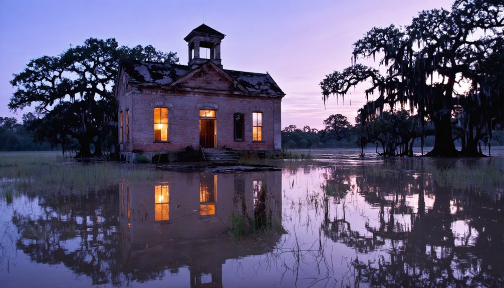
When you drive west from Fort Worth toward the Highland Lakes, you’ll find no highway signs for Old Bluffton—Billy Davis and Isaac B. Maxwell’s 1850s Colorado River settlement now rests under thirty feet of Lake Buchanan water, submerged since Buchanan Dam‘s 1937 completion flooded the town that fire had already destroyed once in 1883.
Severe droughts in 1984 and 2009–2012 dropped the lake by up to fifty feet, exposing cotton gin foundations, stagecoach roads, and graves the Lower Colorado River Authority’s crews missed when they relocated two hundred cemetery burials before inundation.
Meanwhile, 150 miles southwest in Reeves County, Toyah’s 1916 schoolhouse stands abandoned above ground, where paranormal investigators report unexplained voices in classrooms that once educated children from the town’s brief oil-boom prosperity.
Bluffton’s Underwater Resurrection
Beneath Lake Buchanan’s surface lies Old Bluffton, a once-thriving Colorado River settlement that Billy Davis and Isaac B. Maxwell founded in 1852.
When Buchanan Dam’s completion in 1937 flooded the town, residents relocated seven miles west, leaving behind their homes, cotton gin, and general store beneath 20 to 40 feet of water.
You’ll find this submerged history resurfaces during severe droughts. The 2009-2012 drought dropped water levels to 26 feet, exposing foundations, cemetery markers, and building remnants.
The Texas Historical Commission seized this opportunity for archaeological discoveries, recovering medicine bottles, school desk fragments, blacksmith tools, and graves of freed slaves.
These periodic revelations let you glimpse a community that Alfred Hallmark documented as surviving nature’s fury, only to succumb to progress.
Toyah’s Abandoned School Spirits
Far from Lake Buchanan’s submerged streets, Toyah’s two-story brick schoolhouse stands as a different kind of historical marker—one exposed to West Texas sun rather than hidden beneath water.
Built in 1912 when the railroad town peaked at over 1,000 residents, this elementary and high school served generations until consolidation with Pecos in the 1950s.
The top floor was removed during 1960s conversion to a gymnasium, leaving a gutted shell that’s endured decades of abandonment.
Wind howling through empty hallways creates haunted acoustics that fuel Toyah legends among urban explorers and photographers.
The 2004 storms that leveled much of the business district only deepened the ruin’s isolation, making it a stark monument to a community that’s dwindled to roughly ninety souls.
Frequently Asked Questions
Are There Guided Tours Available to Visit These Ghost Towns?
You won’t find formal guided tour options for ghost towns near Fort Worth. Most sites require self-driven exploration, though Thurber offers interpretive signage and a museum highlighting the area’s historical significance independently.
Which Ghost Town Is Closest to Fort Worth for a Day Trip?
Thurber’s your closest option, sitting one hour west on I-20. You’ll discover ghost town history through 1,000+ cemetery graves and mining heritage. Day trip tips: grab brochures beforehand, since few original structures remain standing today.
Can Visitors Legally Explore Abandoned Buildings in These Ghost Towns?
You generally can’t legally enter abandoned structures in Texas ghost towns without owner permission. Most buildings remain private property despite appearing vacant, creating serious legal considerations including criminal trespass charges and civil liability for damage.
What Safety Precautions Should Visitors Take When Exploring Ghost Towns?
Wear sturdy boots and bring first-aid supplies; practice wildlife awareness around snake-prone ruins and old wells. Verify property boundaries, download offline maps, share your itinerary, and carry ample water for remote Texas terrain.
Are There Accommodations Available Near These Ghost Town Locations?
You’ll find motels in nearby towns like Mingus, Weatherford, and Denton, plus camping options near Palo Pinto and Ray Roberts lakes. These bases let you explore multiple ghost towns and local attractions independently.
References
- https://en.wikipedia.org/wiki/List_of_ghost_towns_in_Texas
- https://couriertexas.com/dfw/2024/04/30/north-texas-ghost-towns/
- https://www.hauntedrooms.com/texas/dfw/haunted-places
- https://livefromthesouthside.com/10-texas-ghost-towns-to-visit/
- https://www.hipcamp.com/journal/camping/texas-ghost-towns/
- https://dfwurbanwildlife.com/2011/05/29/chris-jacksons-dfw-urban-wildlife/march-28-2005-ghost-towns-in-north-texas/
- https://authentictexas.com/texas-ghost-towns/
- https://360westmagazine.com/exploring-fort-worths-most-haunted-places-and-local-legends/
- https://www.themoonlitroad.com/ghost-town-thurber-texas/
- https://www.novanumismatics.com/the-ghost-town-tokens-of-thurber-texas/


