You’ll discover abandoned settlements scattered across Haleakalā’s slopes, each with its own poignant story. Keʻanae Peninsula preserves tsunami-battered taro villages, while Hāna’s valleys hide crumbling sugar mill foundations where workers from four continents once toiled. Upcountry Makawao and Kula showcase weathered ranch remnants and shuttered storefronts from paniolo days, and Kīpahulu’s coast reveals ancient stone-walled loʻi terraces abandoned after the whaling era ended. The summit region holds sacred ceremonial sites where temporary shelters once dotted the volcanic landscape—each location offering deeper insights into Maui’s layered past.
Key Takeaways
- Kīpahulu features abandoned stone-walled terraces and coral platforms from villages that thrived until the whaling industry declined in the 1880s.
- Hāna’s sugar plantation remnants include concrete foundations and housing clusters scattered across valleys from a century of sugarcane cultivation.
- Makawao preserves weathered storefronts, disused corrals, and bunkhouses reflecting its historical ranching operations and paniolo culture.
- Kula contains shuttered country stores and stone walls marking former grazing tracts from Portuguese and Chinese farming communities.
- Keʻanae Peninsula shows resilience after the 1946 tsunami destroyed the community, with only the 1856 Congregational Church surviving.
Keʻanae Peninsula: Tsunami-Scarred Taro Villages Along the Road to Hāna
Though Keʻanae Peninsula doesn’t technically qualify as a ghost town, the 1946 tsunami transformed this centuries-old taro farming community into something haunting—a place where only one building survived the waves that swept everything else into the Pacific.
You’ll find over 180 active taro fields here today, evidence of remarkable community resilience. After April 1, 1946, when everything except the 1856 Congregational Church vanished, residents rebuilt their lives and *loi* systems from scratch.
These flooded taro patches represent more than agriculture—they’re ancient Hawaiian innovation, where settlers transformed barren lava into fertile farmland by hauling soil from distant valleys. The region receives 100 to over 300 inches of rainfall annually, creating ideal conditions for taro cultivation and making it the largest single source of surface water in Hawaii.
The taro traditions you’ll witness continue practices disrupted by the 1845 Great Mahele and challenged by ditch construction that diverted stream water. Yet they persist, nourishing cultural identity.
Stop by Aunty Sandy’s snack stand near the church to sample her famous banana bread, a beloved local delicacy that’s become synonymous with visits to the peninsula.
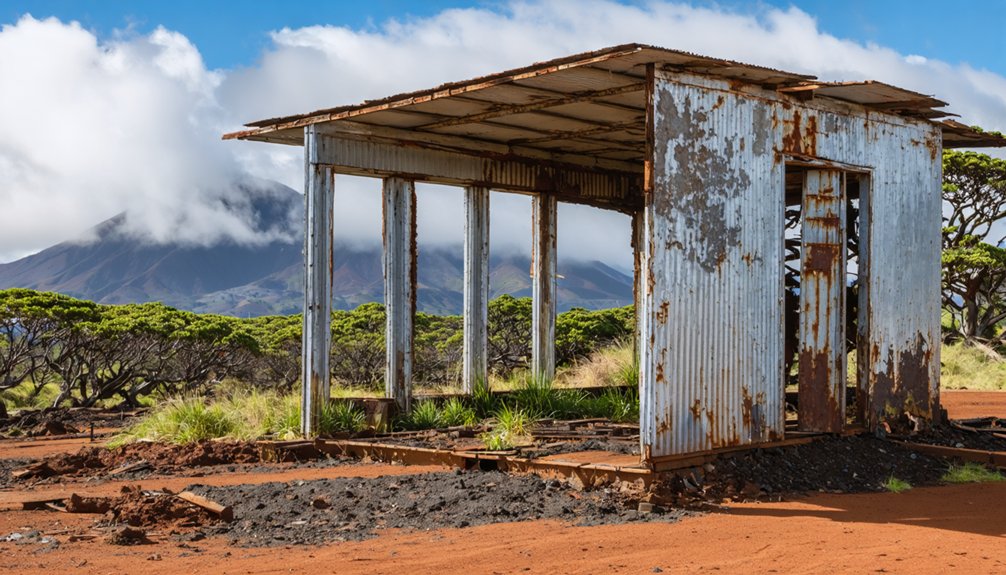
Hāna’s Abandoned Sugar Plantation Remnants and Worker Camps
The rusted bones of Hāna’s sugar empire lie scattered across valleys that once thundered with mill machinery and rang with the voices of workers from four continents.
Silent valleys hold rust and memory where mills once roared and voices of four continents filled the Hawaiian air.
You’ll find concrete foundations swallowed by jungle where the Kaʻeleku mill stood, processing cane from dawn until dark. Overgrown roadbeds snake through pastures, marking routes Chinese, Japanese, Portuguese, and Filipino laborers once walked between field camps and work sites.
These plantation memories live in stone terraces, metal debris, and the faint grid of abandoned housing clusters—each ethnic group maintaining its own temples and gathering halls.
After the last mill closed in the early twentieth century, workers scattered to other islands, leaving Hāna heritage embedded in landscape fragments that ranching and time have nearly erased. Paul Fagan transformed the empty sugarcane fields into a cattle ranch that would reshape the town’s economy and provide new opportunities for displaced workers. The transformation came decades after George Wilfong introduced sugarcane cultivation to Hāna in 1849, launching an industry that would define the region for a century.
Makawao and Kula: Upcountry Ranch Relics and Historic Storefronts
When you climb Haleakalā’s western slopes above the old plantation coast, you’ll enter a different Maui—one shaped by paniolo reins and ranch-gate rhythms rather than mill whistles.
Makawao’s weathered false-front storefronts along Baldwin Avenue stand as monuments to ranching heritage, their 1920s–1930s wooden facades housing galleries where general stores once provisioned vaquero descendants.
You’ll spot disused corrals and bunkhouses scattered across private pastures, remnants of sprawling operations like Haleakalā Ranch that controlled these high grasslands.
Kula’s dispersed hamlets—Keokea, Omaopio, Waiakoa—reveal paniolo culture threaded through Portuguese and Chinese farmsteads.
Stone walls partition former grazing tracts, and shuttered country stores mark crossroads where ranch hands once gathered.
The old Lower Kula Road winds past aging outbuildings and fallow fields, preserving the upcountry’s quiet fade from working landscape to memory.
These cooler elevations support lush pastures and forests that contrast sharply with the arid coastal zones below, creating an unexpected verdant belt across the mountainside.
Kīpahulu’s Coastal Homesteads and Agricultural Ghost Sites
Descend from upcountry pasturelands to Haleakalā’s remote southeastern coast and you’ll discover Kīpahulu’s layered history—where stone-walled loʻi terraces climb forested gulches and coral-rubble platforms mark house sites that once anchored thriving villages.
La Pérouse’s 1786 account described inhabitants so numerous the coastline resembled “a single village” stretching leagues.
Archaeological findings reveal centuries of occupation: coastal settlements dating to A.D. 1161-1384, agricultural terraces cultivating kalo and ʻuala, and structural remains documenting royal power under Kekaulike’s reign.
By the 1880s, the whaling industry’s decline drew residents away to bustling ports like Lāhainā, leaving behind the stone foundations and irrigation networks that ghost these valleys today.
Surveys have documented at least 300 archeological features along the coast, though dense brush conceals additional structures in lands abandoned after sugar plantation operations demolished many historical sites.
Haleakalā Summit Region: Sacred High-Elevation Dwellings Lost to Time
Unlike the coastal villages where families tended loʻi and raised generations, Haleakalā’s summit belonged to the gods.
You’ll find no permanent settlements in this Wao Akua—only windswept shelters tucked against cinder cones and rock outcrops, where travelers paused overnight on journeys through sacred landscapes. These temporary pā served priests conducting ritual practices, navigators reading stars, and bird catchers collecting precious feathers for aliʻi cloaks.
The summit’s “ghost towns” aren’t villages at all—they’re networks of ceremonial platforms, burial caves, and waystations scattered across the crater floor.
These ancient sites tell stories of a bygone era, intriguing visitors who are exploring ghost towns near Hoover Dam. As you wander through the remnants of this historical landscape, each platform reveals secrets of the past, inviting deeper reflection on the lives once lived here. The allure of these ghostly traces draws explorers and historians alike, eager to uncover the mysteries held within the desert’s embrace.
Archaeological surveys reveal pictographs, ahu, and stone alignments marking this kapu domain where Māui snared the sun. Harsh winds, fog, and altitude kept Hawaiians from settling permanently, preserving Haleakalā’s character as a place you visited with reverence, never claimed as home. Early explorations documented these sites using pack mules and horses to navigate the rugged volcanic terrain.
Frequently Asked Questions
Are Ghost Town Sites Near Haleakalā Safe to Explore on My Own?
You’ll find limited ghost town sites near Haleakalā, but solo exploration requires serious safety precautions. Check weather conditions, inform someone of your plans, respect private land, and honor Hawaiian cultural sites. Don’t venture alone without proper preparation.
Do I Need Special Permits to Visit Abandoned Structures Near the Park?
Yes, you’ll need permits. Don’t let red tape dampen your wanderlust—federal land demands Special Use Permits for abandoned structures. Respect exploration guidelines and permit requirements; they protect both you and this sacred ‘āina’s cultural treasures.
Which Ghost Town Is Closest to Haleakalā National Park Entrance?
Kaonoulu is the closest ghost town to Haleakalā’s entrance, resting on the volcano’s southwest flank in central Maui. This former sugar settlement sits roughly 12–18 miles from the park’s summit road, honoring plantation-era stories with quiet respect.
Can I Camp Overnight Near Any Abandoned Settlement Sites?
You’ll want to honor the land’s boundaries—camping regulations prohibit overnight stays near abandoned sites without overnight permits. Designated campgrounds like Hosmer Grove offer legal, respectful alternatives that embrace the island’s spirit while protecting sacred places.
Are Guided Tours Available for Plantation Ruins and Ghost Town Areas?
No guided explorations focus on plantation ruins or ghost towns near Haleakalā. You’ll find museum-based plantation history and living Upcountry towns instead, where you can independently explore their historical significance and cultural heritage at your own pace.
References
- https://nvtami.com/2023/04/26/big-island-hawaii-ghost-towns/
- https://activityauthority.com/ghost-stories-hawaii/
- https://www.worldatlas.com/cities/4-best-gateway-towns-to-haleakal-national-park.html
- https://www.youtube.com/watch?v=Wb5gKrD7cAk
- https://www.shakaguide.com/tours/maui/sunrise-at-haleakala-national-park-tour/stops/makawao-town
- https://www.tripadvisor.com/ShowTopic-g29220-i86-k14558224-Upcountry_towns_and_Haleakala_NP-Maui_Hawaii.html
- https://en.wikipedia.org/wiki/List_of_ghost_towns_in_Hawaii
- https://kids.kiddle.co/List_of_ghost_towns_in_Hawaii
- https://roadtohana.com/wailua-valley.php
- https://www.hawaiiactivities.com/travelguide/keanae-peninsula/


